Items Similar to Antique Dutch Map of The Region of Leeuwarden by Behrns, 1861
Want more images or videos?
Request additional images or videos from the seller
1 of 5
Antique Dutch Map of The Region of Leeuwarden by Behrns, 1861
$143.99
$179.9920% Off
£106.71
£133.3920% Off
€120
€15020% Off
CA$196.80
CA$24620% Off
A$214.23
A$267.7920% Off
CHF 113.71
CHF 142.1420% Off
MX$2,577.67
MX$3,222.0820% Off
NOK 1,440.91
NOK 1,801.1420% Off
SEK 1,320.28
SEK 1,650.3620% Off
DKK 914.08
DKK 1,142.5920% Off
About the Item
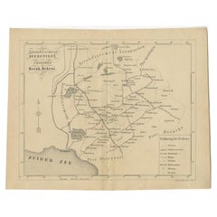
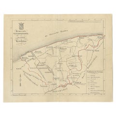
Antique map titled 'Arrondissement Leeuwarden'. Old map depicting the region of Leeuwarden including cities and villages like Franeker, Harlingen, Dokkum and more. This map orginates from 'Zak-Atlas van Friesland in 36 Kaarten'.
Artists and Engravers: Published by B. Behrns, Franeker.
Condition: Good, general age-related toning. Split on folding line, please study image carefully.
Date: 1861
Overall size: 20.9 x 17.1 cm.
Image size: 0.001 x 18.6 x 15 cm.
We sell original antique maps to collectors, historians, educators and interior decorators all over the world. Our collection includes a wide range of authentic antique maps from the 16th to the 20th centuries. Buying and collecting antique maps is a tradition that goes back hundreds of years. Antique maps have proved a richly rewarding investment over the past decade, thanks to a growing appreciation of their unique historical appeal. Today the decorative qualities of antique maps are widely recognized by interior designers who appreciate their beauty and design flexibility. Depending on the individual map, presentation, and context, a rare or antique map can be modern, traditional, abstract, figurative, serious or whimsical. We offer a wide range of authentic antique maps for any budget.
- Dimensions:Height: 6.74 in (17.1 cm)Width: 8.23 in (20.9 cm)Depth: 0 in (0.01 mm)
- Materials and Techniques:
- Period:
- Date of Manufacture:1861
- Condition:
- Seller Location:Langweer, NL
- Reference Number:Seller: BG-05105-21stDibs: LU3054325639512
About the Seller
5.0
Recognized Seller
These prestigious sellers are industry leaders and represent the highest echelon for item quality and design.
Platinum Seller
Premium sellers with a 4.7+ rating and 24-hour response times
Established in 2009
1stDibs seller since 2017
2,816 sales on 1stDibs
Typical response time: 1 hour
- ShippingRetrieving quote...Shipping from: Langweer, Netherlands
- Return Policy
More From This Seller
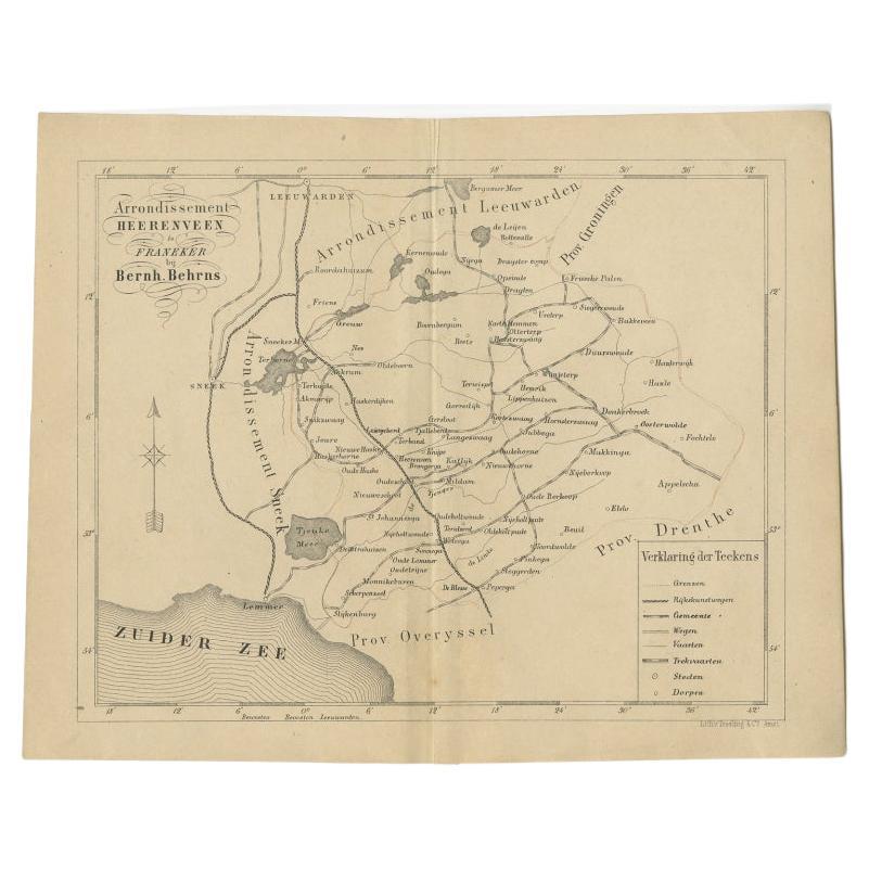
View AllAntique Map of The Region of Heerenveen by Behrns, 1861
Located in Langweer, NL
Antique map titled 'Arrondissement Heerenveen'. Old map depicting the region of Heerenveen including cities and villages like Akkrum, Oudehaske, Wolvega, Donkerbroek and more. This m...
Category
Antique 19th Century Maps
Materials
Paper
$124 Sale Price
20% Off
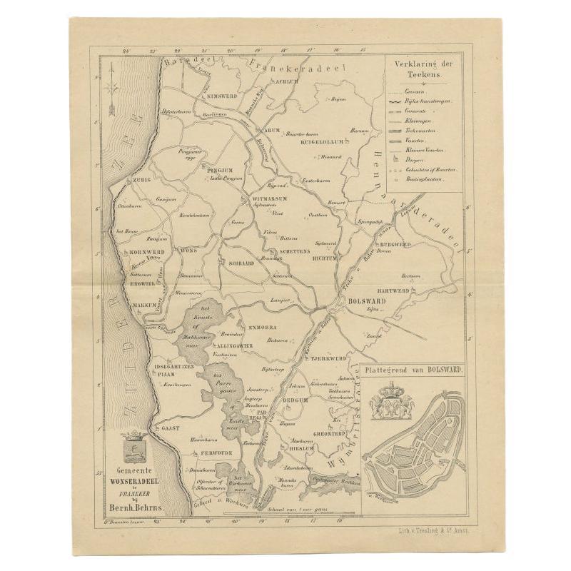
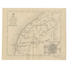
Antique Map of The Wonseradeel Township in Friesland, The Netherlands, 1861
Located in Langweer, NL
Antique map titled 'Gemeente Wonseradeel'. Old map depicting the Wonseradeel township including cities and villages like Kimswerd, Achlum, Arum, Witmarsum, Kornwerd, Hichtum and Bols...
Category
Antique 19th Century Maps
Materials
Paper
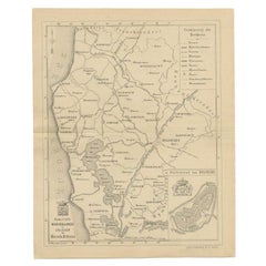
$182 Sale Price
20% Off
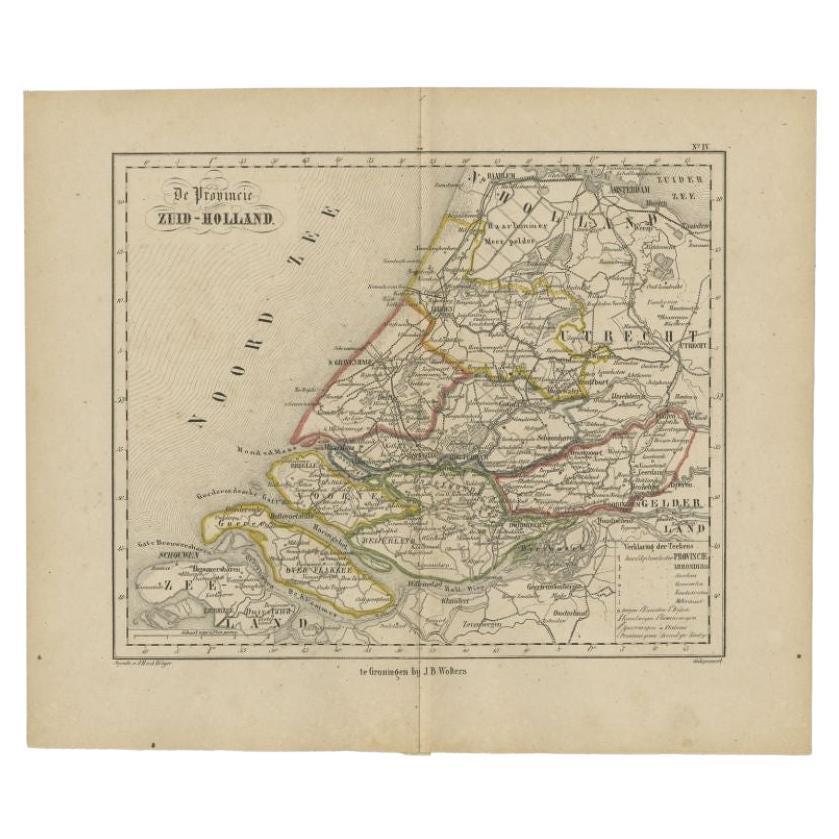
Original Antique Map of Zuid-Holland by Brugsma, 1864
Located in Langweer, NL
Antique map titled 'De Provincie Zuid-Holland'. Map of the province of Zuid-Holland, the Netherlands. This map originates from 'F. C. Brugsma's Atlas van het Koninkrijk der Nederland...
Category
Antique 19th Century Maps
Materials
Paper

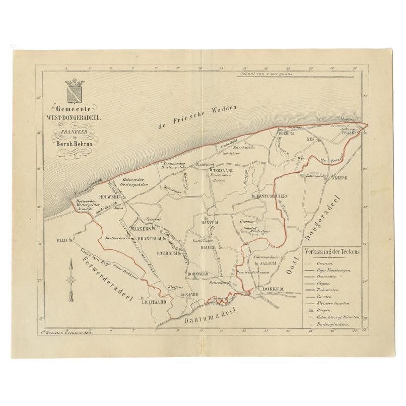
Antique Map of The Dutch West-Dongeradeel Township by Behrns, 1861
Located in Langweer, NL
Antique map titled 'Gemeente West-Dongeradeel'. Old map depicting the West-Dongeradeel township including cities and villages like Holwerd, Ternaard, Hanrum and Raard. This map orgin...
Category
Antique 19th Century Maps
Materials
Paper
$115 Sale Price
20% Off
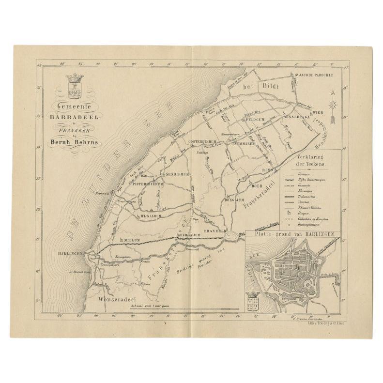
Antique Dutch Map of The Barradeel Township by Behrns, 1861
Located in Langweer, NL
Antique map titled 'Gemeente Barradeel'. Old map depicting the Barradeel township including cities and villages like Midlum, Franeker, Dongjum, Minnertsga, Sexbierum and Harlingen. T...
Category
Antique 19th Century Maps
Materials
Paper
$115 Sale Price
20% Off
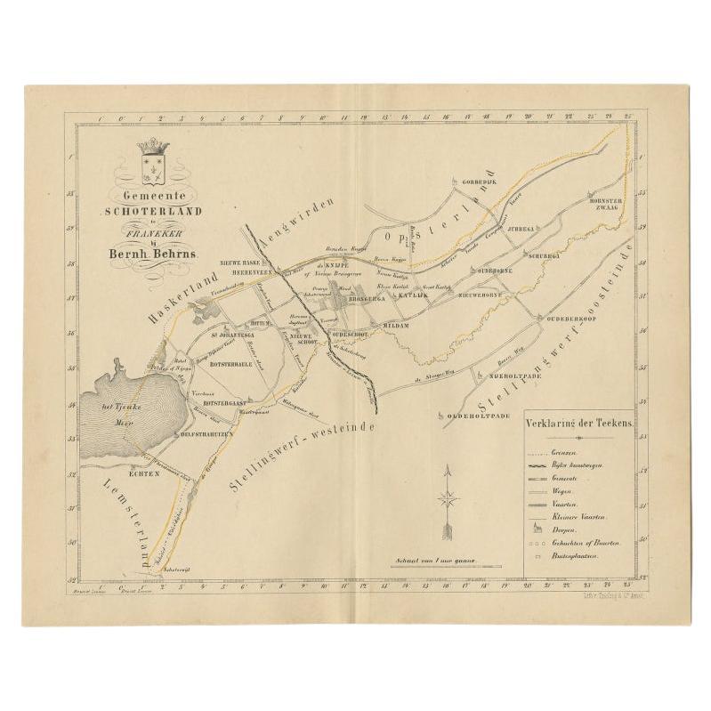
Antique Map of the Schoterland Township in Friesland, the Netherlands, 1861
Located in Langweer, NL
Antique map titled 'Gemeente Schoterland'. Old map depicting the Schoterland township including cities and villages like Rotsterhaule, Delfstrahuizen, Nieuweschoot, Mildam, Katlijk, ...
Category
Antique 19th Century Maps
Materials
Paper
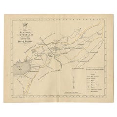
$191 Sale Price
20% Off
You May Also Like
1752 Vaugoundy Map of Flanders : Belgium, France, and the Netherlands, Ric.a002
Located in Norton, MA
Large Vaugoundy Map of Flanders:
Belgium, France, and the Netherlands
Colored -1752
Ric.a002
Description: This is a 1752 Didier Robert de Vaugondy map of Flanders. The map de...
Category
Antique 17th Century Unknown Maps
Materials
Paper

1839 Map of Karte Des "Russischen Reiches in Europa Und Asien" Ric.R0013
Located in Norton, MA
1839 map of Karte Des
"Russischen Reiches in Europa and Asien"
Ric.r013
Map of the European and Asian parts of Russian Empire. Karte der Russischen Reiches in Europa und Asien...
Category
Antique 19th Century Unknown Maps
Materials
Paper

Original Antique English County Map, Cambridgeshire, J
C Walker, 1851
Located in St Annes, Lancashire
Great map of Cambridgeshire
Original colour
By J & C Walker
Published by Longman, Rees, Orme, Brown & Co. 1851
Unframed.
Category
Antique 1850s English Other Maps
Materials
Paper

Original Antique English County Map, Huntingdonshire, J
C Walker, 1851
Located in St Annes, Lancashire
Great map of Huntingdonshire
Original colour
By J & C Walker
Published by Longman, Rees, Orme, Brown & Co. 1851
Unframed.
Category
Antique 1850s English Other Maps
Materials
Paper

Original Antique English County Map - Monmouthshire. J
C Walker. 1851
Located in St Annes, Lancashire
Great map of Monmouthshire
Original colour
By J & C Walker
Published by Longman, Rees, Orme, Brown & Co. 1851
Unframed.
Category
Antique 1850s English Other Maps
Materials
Paper

1851 Map of "Independent Tartary", Ric. R018
Located in Norton, MA
1851 Map of
Independent Tartary
"Russia"
Ric.r018
A highly decorative 1851 map of Independent Tartary by John Tallis and John Rapkin. Covers the regions between the Caspian Sea and Lake Bakquash and between Russia and Afghanistan. These include the ancient Silk Route kingdoms of Khiva, Tartaria, Kokand, and Bokhara. Today this region roughly includes Kazakhstan, Uzbekistan, Turkmenistan, Kyrgyzstan, and Tajikistan. This wonderful map offers a wealth of detail for anyone with an interest in the Central Asian portion of the ancient Silk Road. Identifies various caravan routes, deserts, wells, and stopping points, including the cities of Bokhara and Samarkand. Three vignettes by W. Bragg decorate the map, these including an image of Tartars on a Journey, a horseback Bride Chase, and a tartar camp site. Surrounded by a vine motif border. Engraved by J. Rapkin for John Tallis's 1851 Illustrated Atlas .
Tartary Antique Map...
Category
Antique 19th Century Unknown Maps
Materials
Paper

More Ways To Browse
Antique Texas Furniture
Military Map
Antique Maps New Zealand
Birds Eye View Map
North Africa Map
West Africa Map
Antique Compass Map
Antique Maps California
Biblical Maps
Hungary Map
Maps Of Mediterranean
Treasure Map
Antique Navigational Tools
Mississippi Furniture
Caribbean Antiques
Antique Maps West Indies
Antique Mozambique
Malaysian Antique Furniture