Items Similar to Antique Engraved Map of Manche with Mont Saint-Michel, France, circa 1850


Want more images or videos?
Request additional images or videos from the seller
1 of 9
Antique Engraved Map of Manche with Mont Saint-Michel, France, circa 1850
$345.56
£257.39
€290
CA$475.87
A$517.97
CHF 274.45
MX$6,229.37
NOK 3,489.61
SEK 3,197.84
DKK 2,209.61
About the Item
Antique Map of Manche, France – Mont-St-Michel and Cherbourg Region – c.1850
This highly decorative mid-19th century map of Manche, engraved by A. Vuillemin and published by Levasseur in Paris, is a beautifully detailed representation of this northwestern department of France. With hand-colored department borders and finely engraved surrounding vignettes, it forms part of the renowned *Atlas National Illustré*, a series that combined cartographic accuracy with rich illustrative embellishment.
The map features major towns, rivers, roads, and topographic detail, all labeled in delicate copperplate engraving. The department of Manche, named after the English Channel, is bordered by the sea on three sides and includes some of France’s most iconic coastal and historical landmarks.
Particularly striking is the large vignette at the bottom left featuring Mont-Saint-Michel, the famous tidal island and abbey listed as a UNESCO World Heritage Site. Also depicted are military figures, coats of arms, and a classical figure likely symbolizing regional strength or patriotism, enhancing the visual impact and collectability of the piece.
This map would appeal to collectors of French regional cartography, military or naval history, or those with connections to Normandy or the D-Day region. The inclusion of dozens of historical towns, ports, and strategic locations makes it valuable for both display and research.
**50 Important Places Featured on the Map and Their Significance:**
1. Saint-Lô – Departmental capital
2. Cherbourg – Major naval port
3. Coutances – Historic cathedral town
4. Avranches – Gateway to Mont-Saint-Michel
5. Valognes – Aristocratic heritage town
6. Granville – Fishing and seaside resort
7. Barfleur – Medieval embarkation port
8. Carentan – WWII battle site
9. Mortain – Strategic WWII location
10. Torigni-sur-Vire – Castle and governance
11. Lessay – Famous Romanesque abbey
12. Saint-Sauveur-le-Vicomte – Knightly stronghold
13. La Haye-du-Puits – WWII liberation site
14. Montebourg – WWII parachute drop
15. Périers – Battle of Normandy
16. Saint-Hilaire-du-Harcouët – Market and pilgrimage site
17. Bréhal – Coastal resort town
18. Ducey – Château and bridges
19. Villedieu-les-Poêles – Copper crafts hub
20. Saint-James – American war cemetery
21. Pontorson – Access to Mont-Saint-Michel
22. Isigny – Butter and dairy center
23. Portbail – Ancient Roman port
24. Quettehou – English landing site
25. Beaumont-Hague – Nuclear research center
26. Bricquebec – Feudal castle ruins
27. Saint-Vaast-la-Hougue – Vauban fortifications
28. Saint-Clair-sur-l’Elle – Strategic river crossing
29. Barneville – Twin town with Carteret
30. Hambye – Abbey ruins site
31. Saint-Pair-sur-Mer – Seaside retreat
32. Canisy – Château and WWII damage
33. Sainte-Mère-Église – First liberated town WWII
34. Jullouville – Coastal holiday spot
35. Donville-les-Bains – Thermal spa town
36. Tourlaville – Industrial suburb of Cherbourg
37. Domjean – Rural charm and church
38. Saint-Laurent-de-Cuves – Cultural festival venue
39. Notre-Dame-de-Cenilly – Parish and heritage site
40. Saint-Denis-le-Gast – Rural historical village
41. Vire – Fortified border town
42. Marigny – WWII battle site
43. Cérences – Local commerce hub
44. Saint-Fromond – River crossing importance
45. Saint-Michel-de-Montjoie – Granite quarry village
46. Percy – Village with church ruins
47. La Glacerie – Near Cherbourg Arsenal
48. Agon-Coutainville – Popular beach resort
49. Roncey – Picturesque countryside commune
50. Le Teilleul – Border village near Mayenne
Condition Report:
Excellent condition with light age toning to the margins. Plate mark visible. No tears or foxing.
Framing Suggestions:
For an elegant and timeless presentation, frame with a dark walnut or black wooden frame and a double mat: outer mat in ivory and inner mat in pale grey or French blue to highlight the coastal theme. Ideal for libraries, living rooms, or offices with a historical or nautical decor.
Technique: Engraving with hand-color
Maker: A. Vuillemin, Paris, circa 1850
Published by: Levasseur, Paris
- Dimensions:Height: 12.8 in (32.5 cm)Width: 10.28 in (26.1 cm)Depth: 0.01 in (0.2 mm)
- Materials and Techniques:Paper,Engraved
- Place of Origin:
- Period:
- Date of Manufacture:circa 1850
- Condition:Excellent condition with light age toning to the margins. Centerfold as issued. Plate mark visible. No tears or foxing.
- Seller Location:Langweer, NL
- Reference Number:Seller: BG-13331-491stDibs: LU3054347401632
About the Seller
5.0
Recognized Seller
These prestigious sellers are industry leaders and represent the highest echelon for item quality and design.
Platinum Seller
Premium sellers with a 4.7+ rating and 24-hour response times
Established in 2009
1stDibs seller since 2017
2,824 sales on 1stDibs
Typical response time: 1 hour
- ShippingRetrieving quote...Shipping from: Langweer, Netherlands
- Return Policy
More From This Seller
View AllAntique Map of Marne, France – Engraved by Levasseur, 1850s
Located in Langweer, NL
Antique Map of Marne, France – Engraved by Levasseur, 1850s
This beautifully detailed 19th-century engraved map of the Marne department in northeastern France was created by the ren...
Category
Antique Mid-19th Century French Maps
Materials
Paper

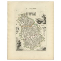
Antique Map of Haute-Marne France by Vuillemin with Decorative Insets, 1850s
Located in Langweer, NL
Antique Map of Haute-Marne France by Vuillemin with Decorative Insets, 1840s
This finely engraved and hand-colored map of Haute-Marne, a historical department in northeastern France...
Category
Antique Mid-19th Century French Maps
Materials
Paper
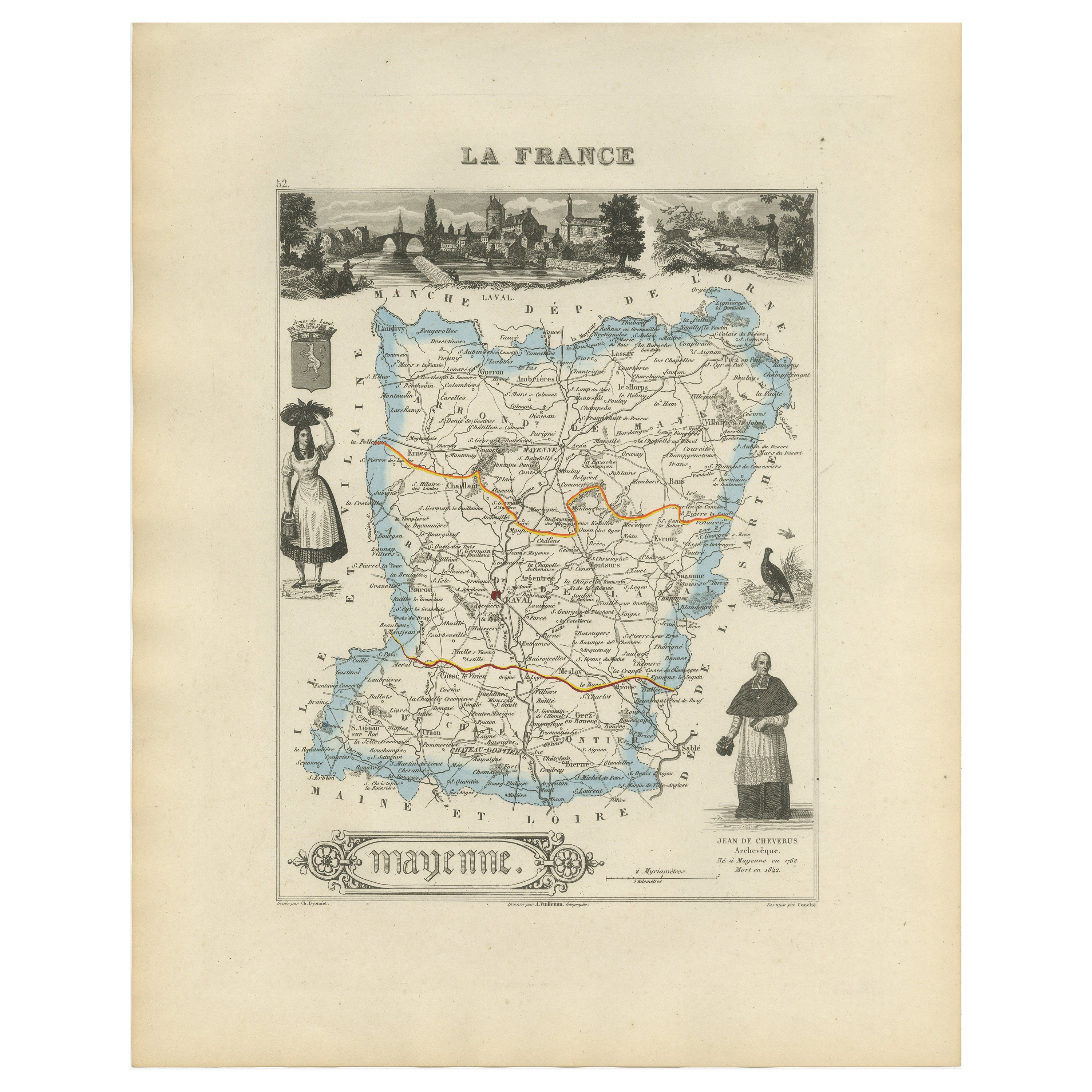
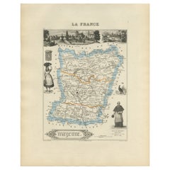
Antique Map of Mayenne – Hand-Colored Engraving by Levasseur, France c.1850
Located in Langweer, NL
Antique Map of Mayenne – Hand-Colored Engraving by Levasseur, France c.1850
This finely detailed 19th-century engraved map of the department of Mayenne in northwestern France was cr...
Category
Antique Mid-19th Century French Maps
Materials
Paper
Map of Côtes-du-Nord France with Saint-Brieuc and Brittany Coastline, c.1850
Located in Langweer, NL
Map of Côtes-du-Nord France with Saint-Brieuc and Brittany Coastline, 19th c
Description:
This elegant 19th-century map of Côtes-du-Nord, the historic name for what is now known as ...
Category
Antique Mid-19th Century French Maps
Materials
Paper

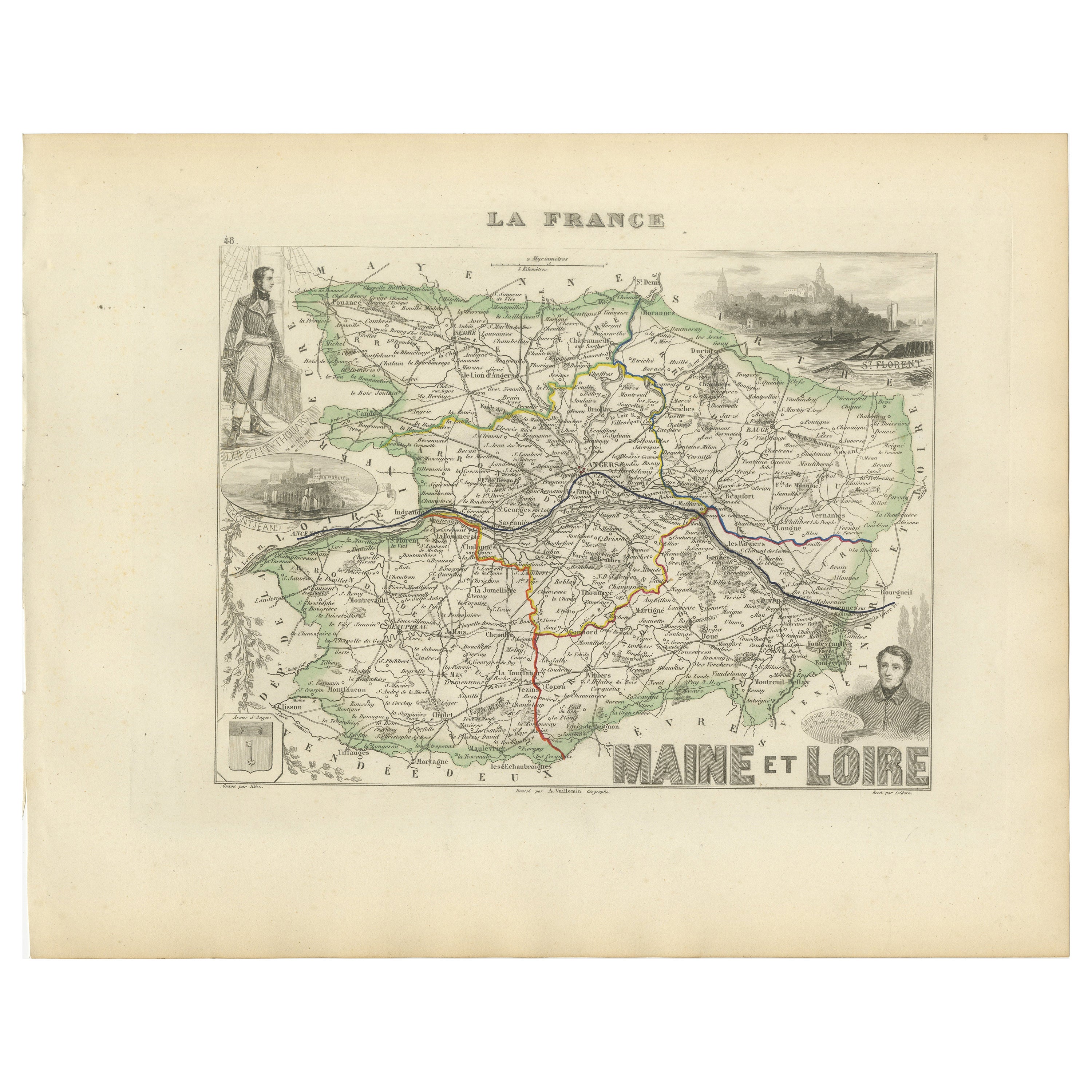
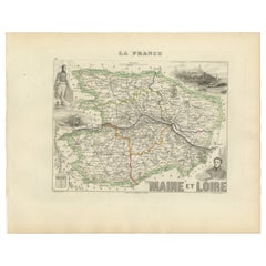
Antique Map of Maine-et-Loire with Illustrations – Vuillemin c.1850
Located in Langweer, NL
Antique Map of Maine-et-Loire with Illustrations – Vuillemin c.1850
A richly detailed 19th-century map of the Maine-et-Loire department in western France, engraved by A. Vuillemin a...
Category
Antique Mid-19th Century French Maps
Materials
Paper
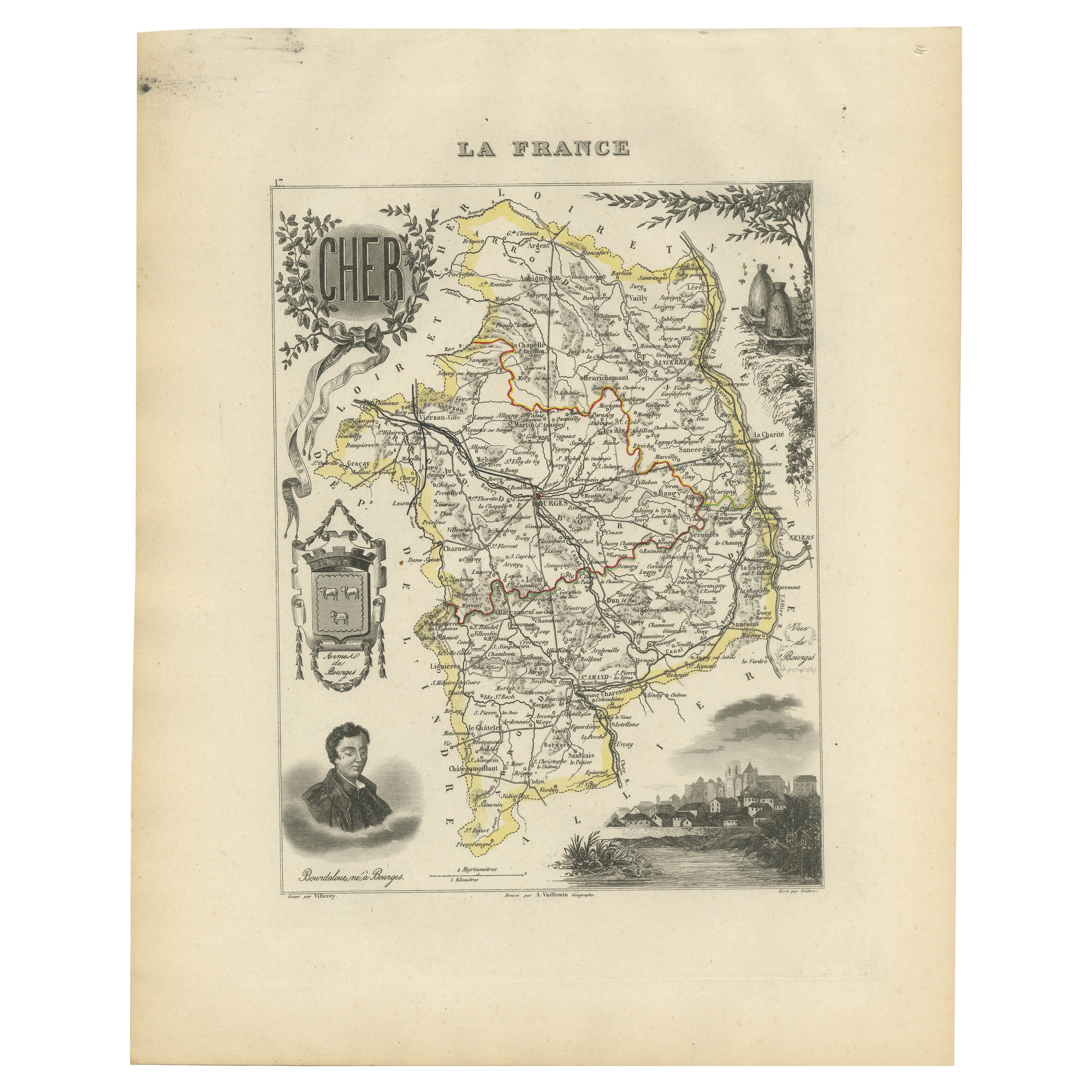
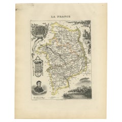
Map of Cher France with Bourges, Sancerre Vineyards and Engraved Vignettes, 1850
Located in Langweer, NL
Map of Charente-Inférieure France with La Rochelle and Coastal Vineyards, 19th c
Description:
This decorative 19th-century map of the former department of Charente-Inférieure, now k...
Category
Antique Mid-19th Century French Maps
Materials
Paper
You May Also Like
Map of France - Etching - 1820
Located in Roma, IT
Map of France is an Original Etching realized by an unknown artist of 19th century in 1820.
Very good condition on two sheets of white paper joined at t...
Category
1820s Modern Figurative Prints
Materials
Etching

Map of Rhône - Original Etching - 19th Century
Located in Roma, IT
Map of Rhône is an original antique etching realized by an anonymous engraver of the 19th Century.
Printed in series of "France Pittoresque" at the top center.
The state of preserv...
Category
19th Century Modern Figurative Prints
Materials
Etching

France, Northern Part. Century Atlas antique map
Located in Melbourne, Victoria
'The Century Atlas. France, Northern Part.'
Original antique map, 1903.
Inset maps of 'France in Provinces' and 'Paris and Vicinity'.
Central fold as issued. Map name and number pr...
Category
Early 20th Century Victorian More Prints
Materials
Lithograph

Lozere, France. Antique map of a French department, 1856
By Victor Levasseur
Located in Melbourne, Victoria
'Dept. de La Lozere', steel engraving with original outline hand-colouring., 1856, from Levasseur's 'Atlas National Illustre'.
This remote mountainous part of Languedoc is rural, s...
Category
19th Century Naturalistic Landscape Prints
Materials
Engraving

Indre and Loire, France. Antique map of a French department, 1856
By Victor Levasseur
Located in Melbourne, Victoria
'Dept. d'Indre et Loire', steel engraving with original outline hand-colouring., 1856, from Levasseur's 'Atlas National Illustre'.
This area is known for its production of Chenin b...
Category
19th Century Naturalistic Landscape Prints
Materials
Engraving

Var, France. Antique map of a French department, 1856
By Victor Levasseur
Located in Melbourne, Victoria
'Dept. du Var', steel engraving with original outline hand-colouring., 1856, from Levasseur's Atlas National Illustre.
Var covers the heart of the French Riviera or Cote d'Azur., and includes the resort cities of Cannes, Nice and San Tropez...
Category
19th Century Naturalistic Landscape Prints
Materials
Engraving
