Items Similar to Antique French Map of the Holy Land, Twelve Tribes of Israel, c.1750


Want more images or videos?
Request additional images or videos from the seller
1 of 11
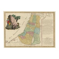
Antique French Map of the Holy Land, Twelve Tribes of Israel, c.1750
$1,314.14
£982.12
€1,100
CA$1,812.92
A$1,985.71
CHF 1,045.48
MX$23,698.84
NOK 13,323.69
SEK 12,179.86
DKK 8,384.36
About the Item
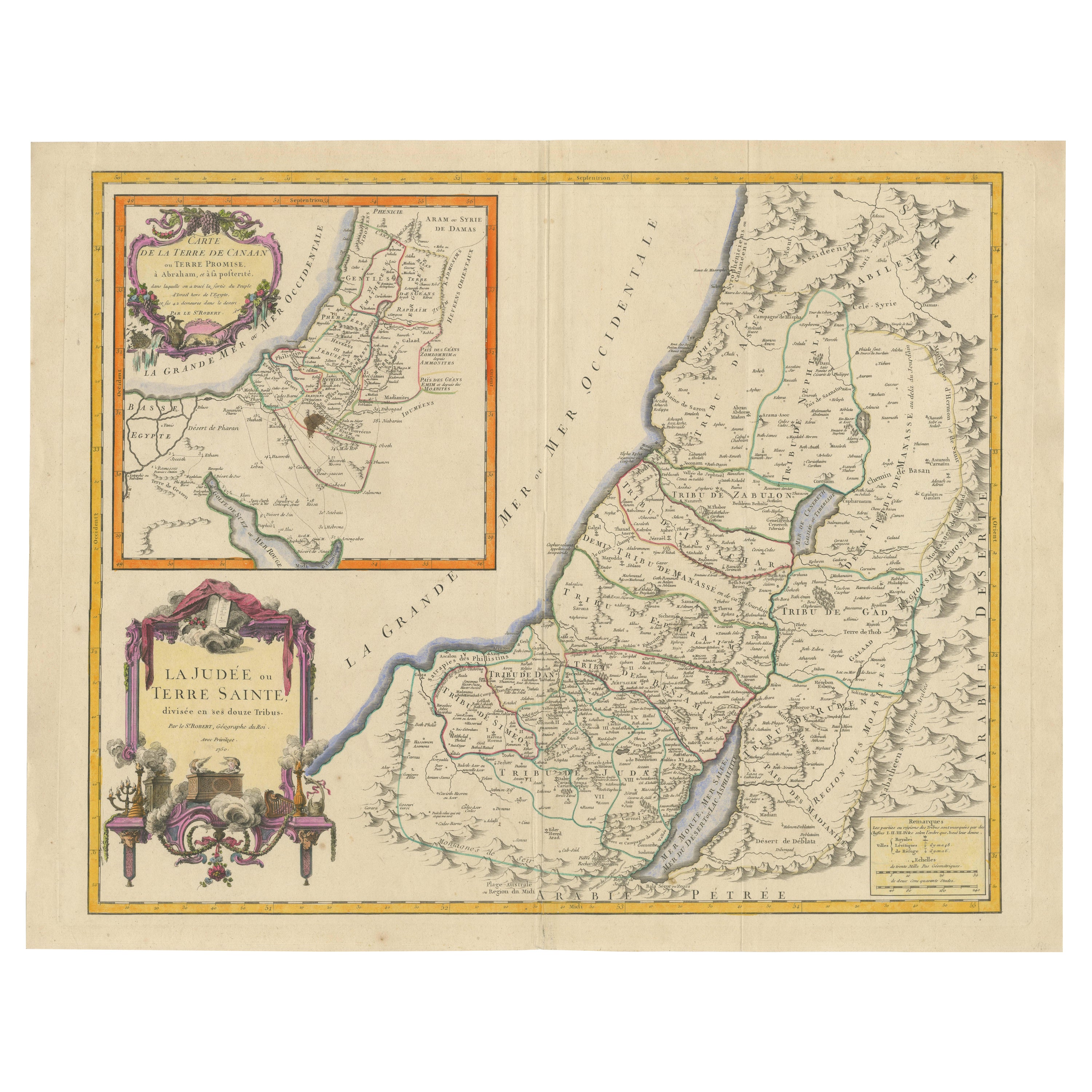
Antique Holy Land Map, Twelve Tribes of Israel – Robert de Vaugondy, c.1750
Description
This finely engraved and hand-colored map depicts Judea, or the Holy Land, divided according to the Twelve Tribes of Israel, each territory carefully delineated with colored boundaries and identified by name. The composition reflects the scholarly French cartographic tradition of the mid-18th century, combining biblical geography with contemporary geographic knowledge in a visually balanced and highly legible format.
The map was produced in Paris around 1750 by Robert de Vaugondy, one of the most respected mapmakers of the Enlightenment period. Vaugondy’s work is known for its precision, clarity, and elegant ornamentation, qualities that made his maps popular with scholars, collectors, and institutions throughout Europe.
An inset map in the upper left shows Canaan, or the Promised Land, extending into Phoenicia and Syria, with the northeastern reaches of Egypt also indicated. Geographic features such as coastlines, rivers, mountain ranges, deserts, and settlements are carefully rendered, while the Mediterranean Sea and surrounding regions are clearly labeled. The decorative cartouche adds refinement without overwhelming the map’s academic character, making it equally suitable for a study, library, or refined interior.
Maps of the Holy Land from this period remain highly sought after for their historical, religious, and decorative significance. This example offers a particularly appealing balance of scholarship and visual presence, with strong original hand coloring enhancing both the tribal divisions and the overall composition.
Condition report
Good antique condition. Original central fold as issued. Light age toning and minor handling marks consistent with 18th-century paper. No losses or major defects. Overall well-preserved with strong clarity of engraving and color.
Framing tips
This map presents beautifully with a muted walnut or dark ebonized frame paired with an off-white or parchment mat. For a more traditional look, an antique gold frame with a narrow profile will subtly echo the cartouche while maintaining a refined, scholarly appearance.
Technique: Engraving with original hand color
Maker: Robert de Vaugondy, Paris, circa 1750
- Dimensions:Height: 20.08 in (51 cm)Width: 26.78 in (68 cm)Depth: 0.01 in (0.2 mm)
- Materials and Techniques:Paper,Engraved
- Place of Origin:
- Period:
- Date of Manufacture:circa 1750
- Condition:Good antique condition. Original central fold as issued. Light age toning and minor handling marks consistent with 18th-century paper. No losses or major defects. Overall well-preserved with strong clarity of engraving and color.
- Seller Location:Langweer, NL
- Reference Number:Seller: BG-14152-21stDibs: LU3054348066812
About the Seller
5.0
Recognized Seller
These prestigious sellers are industry leaders and represent the highest echelon for item quality and design.
Platinum Seller
Premium sellers with a 4.7+ rating and 24-hour response times
Established in 2009
1stDibs seller since 2017
2,806 sales on 1stDibs
Typical response time: 1 hour
- ShippingRetrieving quote...Shipping from: Langweer, Netherlands
- Return Policy
More From This Seller
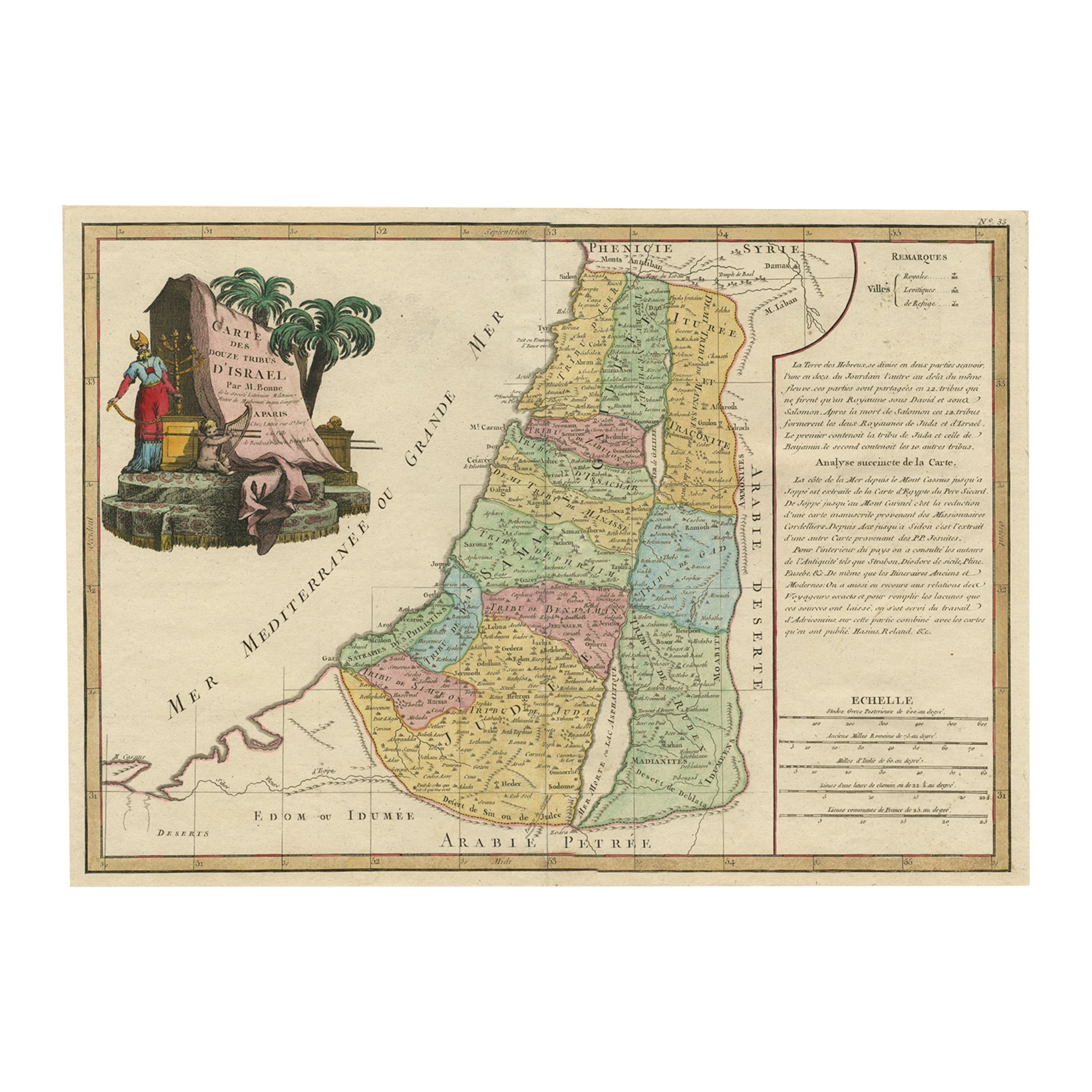
View All1750 Map of the Holy Land: The Land of Canaan and the Twelve Tribes
Located in Langweer, NL
Carte de la Terre de Canaan ou Terre Promise
Cartographer: Le St. Robert
Date of Publication: 1750
This exquisite 18th-century map, 'Carte de la Terre de Canaan ou Terre Promise', w...
Category
Antique 1750s French Maps
Materials
Paper

Holy Land Map of the Twelve Tribes of Israel – Sanson, Hand Colored, 1696
Located in Langweer, NL
Holy Land Map of the Twelve Tribes of Israel – Sanson, Hand Colored, 1696
Description:
This impressive and richly hand-colored map of the Holy Land depicts the biblical territories ...
Category
Antique Late 17th Century French Maps
Materials
Paper
Original Rare Map of the Holy Land Showing the Twelve Tribes of Israel
s, 1782
Located in Langweer, NL
Antique map titled 'Carte des Douze Tribus D'Israel (..).'
Map of the Holy Land showing the twelve tribes of Israel's. Tribes are all named...
Category
Antique 1780s Maps
Materials
Paper
$659 Sale Price
20% Off
1658 Large Map of the Holy Land by Jansson – Twelve Tribes of Israel in 6 Sheets
Located in Langweer, NL
Holy Land Divided Among the Twelve Tribes – Six-Part Map by Jan Jansson and Georgius Hornius, circa 1658
This rare and impressive six-sheet engraved map of the Holy Land was publish...
Category
Antique Mid-17th Century Dutch Maps
Materials
Paper

$3,536 Sale Price / set
20% Off
Highly Detailed Antique Map of the Holy Land Showing 12 Tribes of Israel, c.1720
Located in Langweer, NL
Antique map titled 'Heylige Land verdeeld in de Twaalf Stammen Israels (..).'
Highly detailed map of the Holy Land divided into 12 tribes of Israel...
Category
Antique 1720s Maps
Materials
Paper

$458 Sale Price
20% Off
Free Shipping
1718 Holy Land Map - Twelve Tribes, Six Provinces, Hand-Colored, Antique Map
Located in Langweer, NL
Title: Terra Sancta in XII olim Tribus nunc VI Provincias Dispertita
Cartographer: Christoph Weigel the Elder (1654–1725)
Publisher: Johann Ernst Adelbulner
Publication Locatio...
Category
Antique 1710s German Maps
Materials
Paper

You May Also Like
The Holy Land at the Time of Jesus: A 17th Century Dutch Map by Visscher
By Nicolaes Visscher II
Located in Alamo, CA
This detailed Dutch map entitled "Het Beloofe de Landt Canaan door wandelt van onsen Salichmaecker Iesu Christo, nessens syne Apostelen" by Nicolaes Visscher was published in Amsterd...
Category
Antique Mid-17th Century Dutch Maps
Materials
Paper

Map of the Holy Land "Carte de la Syrie et de l
Egypte" by Pierre M. Lapie
By Pierre M. Lapie
Located in Alamo, CA
An early 19th century map of ancient Syria and Egypt entitled "Carte de la Syrie et de l'Egypte anciennes/dressée par M. Lapie, Colonel d'Etat Major, et...
Category
Antique Early 19th Century French Maps
Materials
Paper

Map Holy Land La Terre Sainte Engraved van Loon Published N de Fer 1703 French
Located in BUNGAY, SUFFOLK
La Terre Sainte, The Holy Land, Tiree Des Memoires De M.De.La Rue. Par N. de Fer. Geographe de Sa Majeste Catoliq et de Monseigneur le Dauphin. Avec Privil du Roi 1703
Detailed map of the Holy Land from Nicholas de Fer's L'Atlas Curieux ou le Monde. East is oriented at the top.
MAKER Nicolas de Fer 1646-1720
The French cartographer and engraver, Nicolas de Fer, was a master at creating maps that were works of art. The maps that he published were printed during the Baroque period when the decorative arts were characterized by ornate detail. De Fer’s detailed maps and atlases were valued more for their decorative content than their geographical accuracy.
Nicolas de Fer was born in 1646. His father, Antoine de Fer, owned a mapmaking firm. At the age of twelve, Nicolas was apprenticed to a Parisian engraver named Louis Spirinx. The family business was starting to decline when his father died in 1673. Nicolas de Fer’s mother, Genevieve, took over the business after the death of her husband. In 1687 the business was passed on to Nicolas and the profits increased after he took over the firm. Nicolas de Fer was a prolific cartographer who produced atlases and hundreds of single maps. He eventually became the official geographer to King Louis XIV of France and King Philip V...
Category
Antique Early 1700s French Louis XIV Maps
Materials
Paper

Antique Map of Virginia
the Chesapeake Bay by Jacques-Nicolas Bellin, c. 1750
By Jacques-Nicolas Bellin
Located in Philadelphia, PA
A fine antique 18th century French map of North America.
By Jacques-Nicolas Bellin.
On laid paper with polychrome highlights.
Depicting Virginia, the Chesapeake Bay, and the nearb...
Category
Antique 18th Century French Baroque Maps
Materials
Paper

Map Holy Promise Land Canaan Richard Palmer Richard Blome 1687 Joseph Moxon
Located in BUNGAY, SUFFOLK
Canaan comonly called the Holy Land or the Land of Promise, being the Possesion of the Israelites & travelled through by Our Lord & Saviour Iesus Christ and his Apostles. Engraven by Richard Palmer for Richard Blome. 1687
Blome, Richard, 1641-1705. London. 283 x 452 mm. Copperplate.
Probably from an English Bible...
Category
Antique 17th Century British Baroque Maps
Materials
Paper

19th Century Holy Land Mother-of-Pearl Icon
Located in London, GB
This fantastic mother-of-pearl icon was made in Jerusalem at the end of the 19th century, and is beautifully carved with mother-of-pearl and set with abalon...
Category
Antique Late 19th Century Israeli Religious Items
Materials
Mother-of-Pearl