Items Similar to Antique French Map of Indre-et-Loire with Tours, Amboise, Chinon, 1800s


Want more images or videos?
Request additional images or videos from the seller
1 of 11
Antique French Map of Indre-et-Loire with Tours, Amboise, Chinon, 1800s
$167.99
£124.49
€140
CA$229.60
A$249.94
CHF 132.67
MX$3,007.28
NOK 1,681.07
SEK 1,540.33
DKK 1,066.42
About the Item
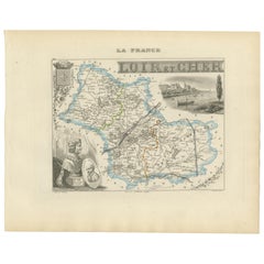
Antique Map of Indre-et-Loire, France by Vuillemin, 19th Century
This beautifully engraved map illustrates the département of Indre-et-Loire, located in the Centre-Val de Loire region of France. Produced in the mid-19th century by Alexandre Vuillemin, it comes from his celebrated atlas of the French départements, notable for combining precise cartography with decorative embellishments.
The map shows the towns, rivers, and major roads of the département, with departmental borders outlined in original hand color. Surrounding the map are finely engraved portraits and vignettes that celebrate the region’s historical and cultural heritage. Portraits include Charles VII, the French king, and the celebrated Renaissance writer François Rabelais. At the bottom right is a portrait of Destouches, the French dramatist. A vignette at lower left shows the evocative ruins of the Château de Loches, a medieval fortress of great historical importance.
Indre-et-Loire is the heart of the Loire Valley, renowned for its châteaux, vineyards, and as a cradle of French history and literature. By pairing geographical detail with decorative elements, Vuillemin’s map serves as both a reference tool and a celebration of regional identity.
Alexandre Vuillemin (1812–1880), a noted French cartographer, produced many atlases and maps distinguished by their clarity and artistic framing. His atlas of France’s départements remains a valuable resource for collectors and historians alike.
Condition report: Excellent condition with crisp impression and well-preserved hand coloring. Very light toning and occasional minor foxing in the margins, not affecting the image.
Framing tips: Best displayed in a dark walnut or ebonized frame with a wide cream or ivory mat to highlight the vignette details. A subtle gold fillet could enhance the map’s decorative character.
Technique: Engraving with original hand color
Maker: Alexandre Vuillemin, France, mid-19th century
- Dimensions:Height: 12.8 in (32.5 cm)Width: 10.28 in (26.1 cm)Depth: 0.01 in (0.2 mm)
- Materials and Techniques:Paper,Engraved
- Place of Origin:
- Period:
- Date of Manufacture:circa 1850
- Condition:Condition report: Excellent condition with crisp impression and well-preserved hand coloring. Very light toning and occasional minor foxing in the margins, not affecting the image.
- Seller Location:Langweer, NL
- Reference Number:Seller: BG-13331-361stDibs: LU3054346798082
About the Seller
5.0
Recognized Seller
These prestigious sellers are industry leaders and represent the highest echelon for item quality and design.
Platinum Seller
Premium sellers with a 4.7+ rating and 24-hour response times
Established in 2009
1stDibs seller since 2017
2,819 sales on 1stDibs
Typical response time: 1 hour
- ShippingRetrieving quote...Shipping from: Langweer, Netherlands
- Return Policy
More From This Seller
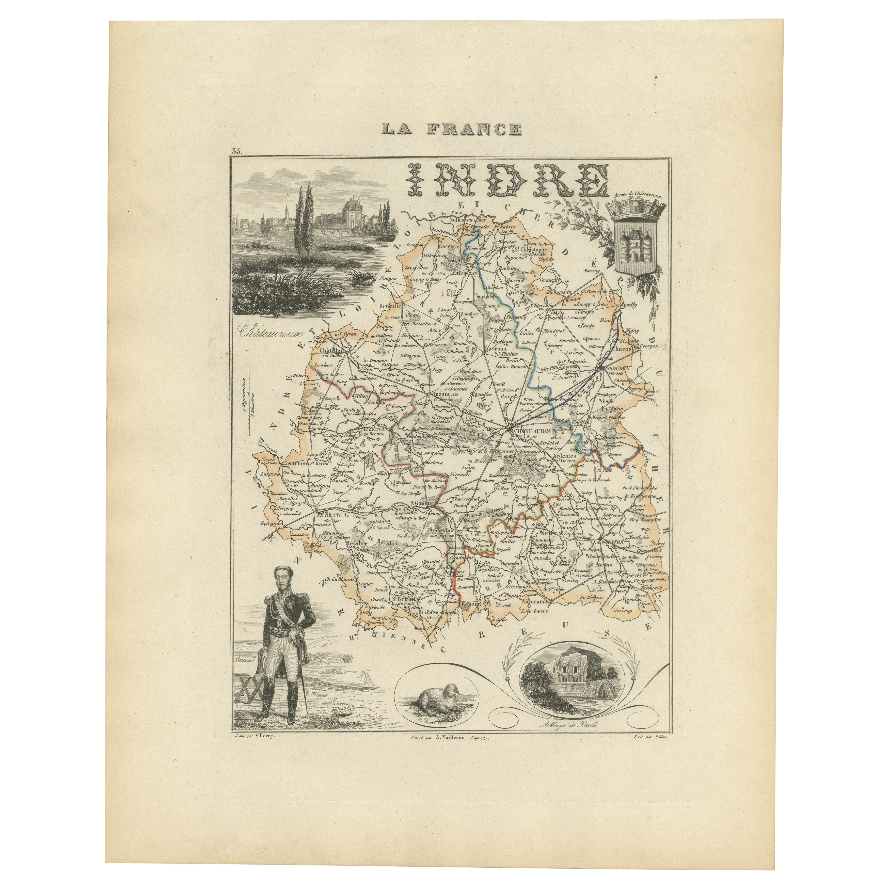
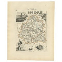
View AllAntique French Map of Indre Region with Châteauroux and Issoudun, 1800s
Located in Langweer, NL
Antique Map of Indre, France by Vuillemin, 19th Century
This fine decorative map presents the département of Indre, situated in the Centre-Val de Loire region of central France. Eng...
Category
Antique Mid-19th Century French Maps
Materials
Paper
Map of Loire France with Saint-Étienne and Montbrison by Vuillemin, 19th c
Located in Langweer, NL
Map of Loire France with Saint-Étienne and Montbrison by Vuillemin, 19th c
This beautifully engraved and hand-colored map of the department of Loire in east-central France is from t...
Category
Antique Mid-19th Century French Maps
Materials
Paper

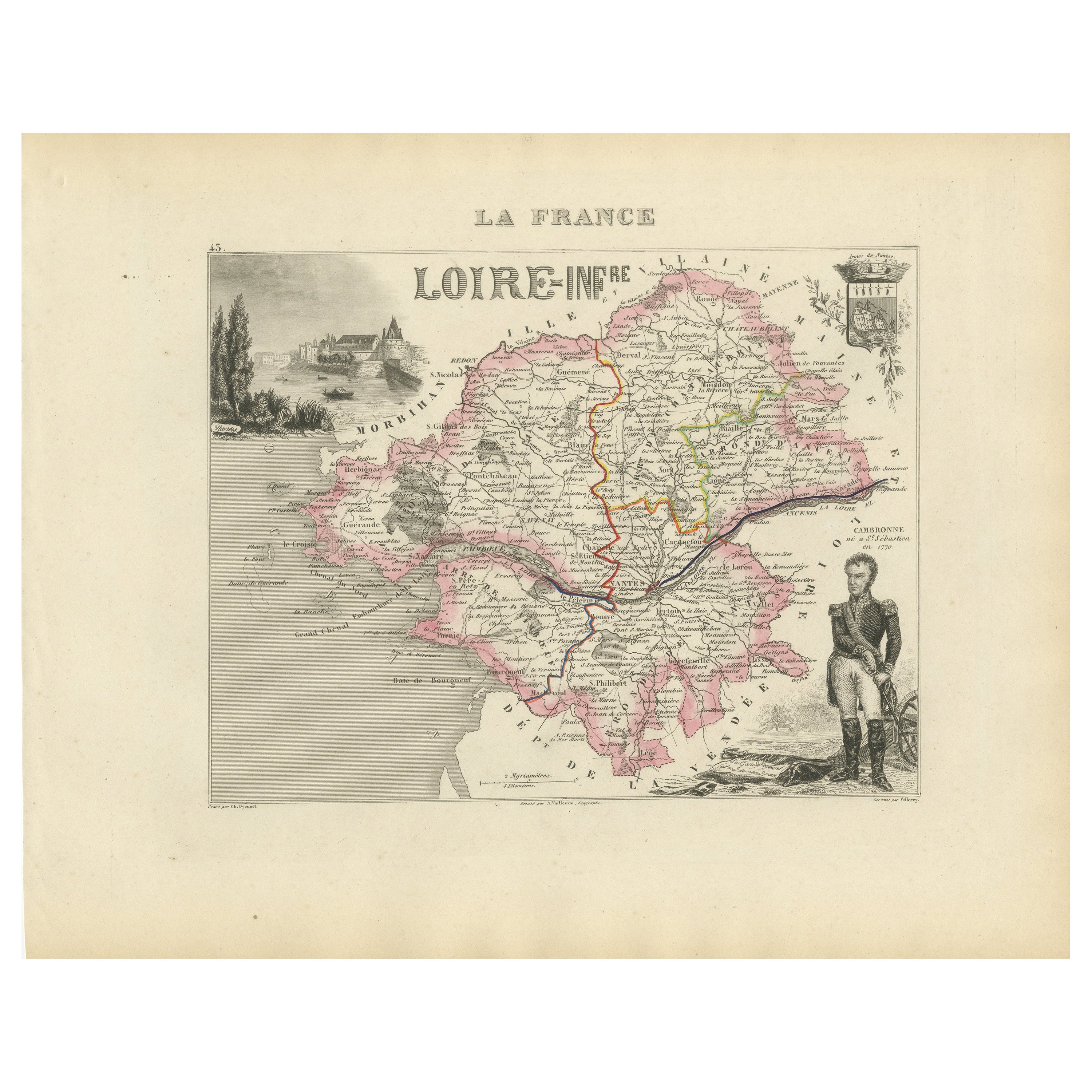
Map of Loire-Inférieure France with Nantes and Estuary by Vuillemin, 19th c
Located in Langweer, NL
Map of Loire-Inférieure France with Nantes and Estuary by Vuillemin, 19th c
This finely engraved and hand-colored map of Loire-Inférieure (modern-day Loire-Atlantique) was created b...
Category
Antique Mid-19th Century French Maps
Materials
Paper
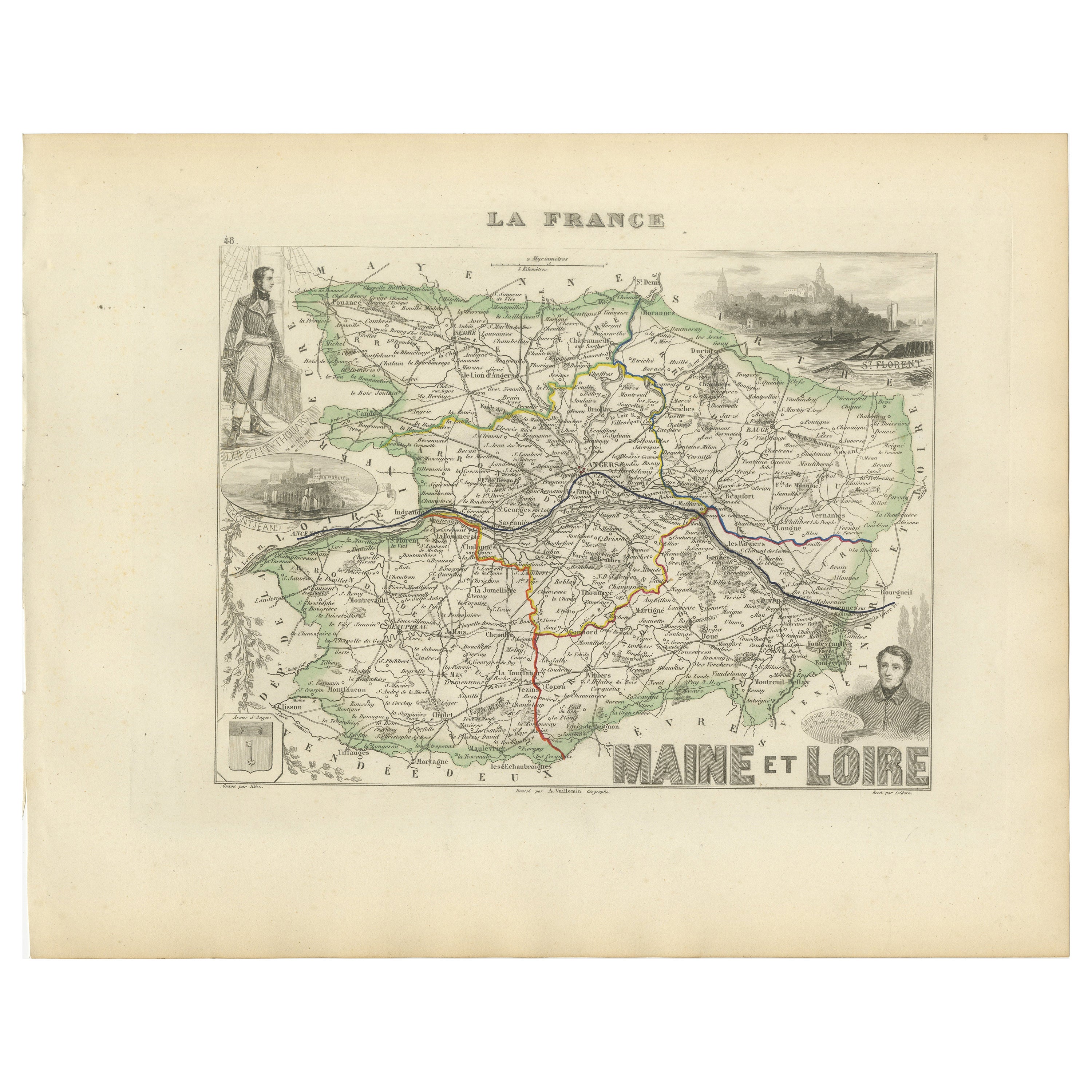
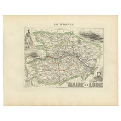
Antique Map of Maine-et-Loire with Illustrations – Vuillemin c.1850
Located in Langweer, NL
Antique Map of Maine-et-Loire with Illustrations – Vuillemin c.1850
A richly detailed 19th-century map of the Maine-et-Loire department in western France, engraved by A. Vuillemin a...
Category
Antique Mid-19th Century French Maps
Materials
Paper
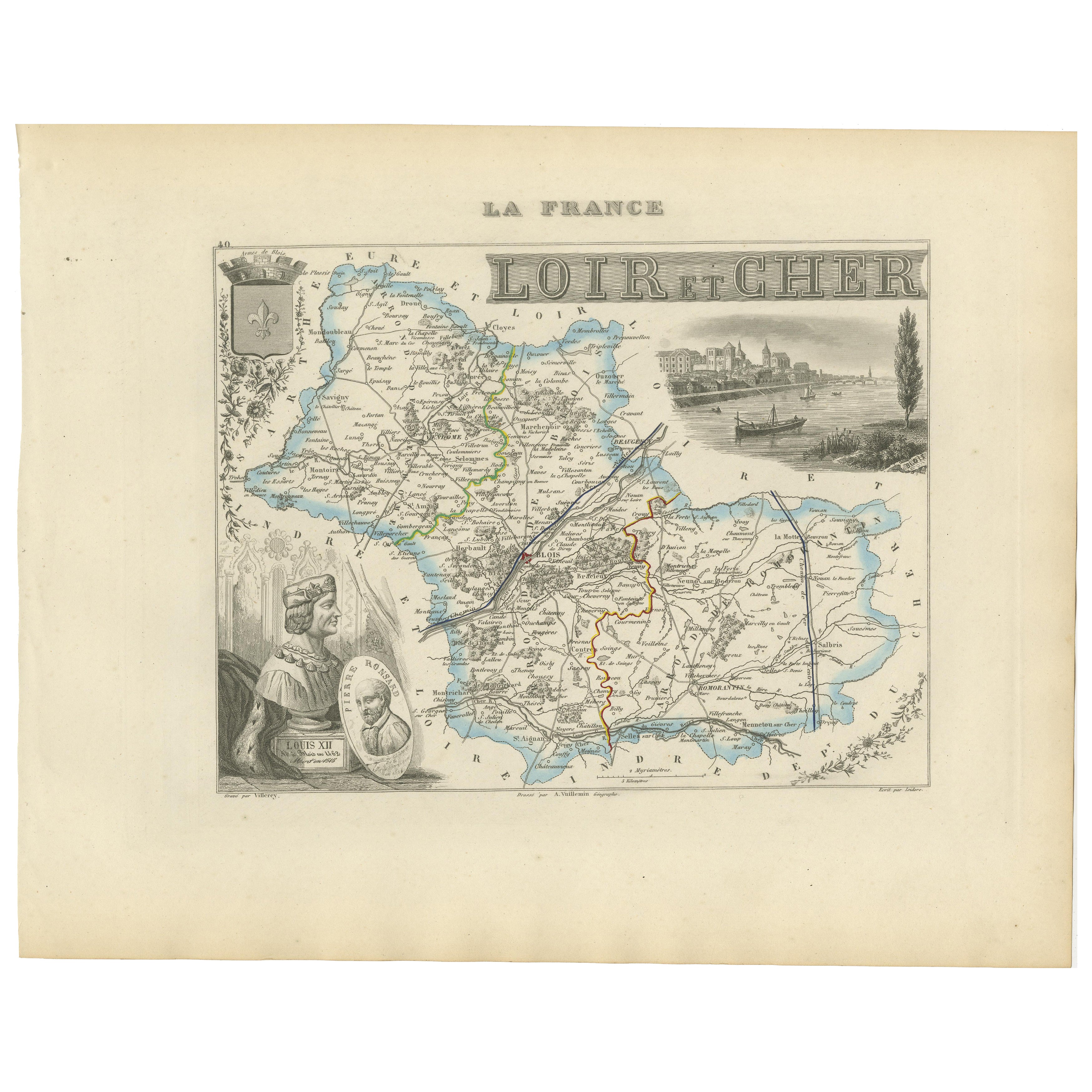
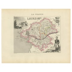
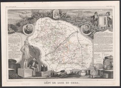
19th Century Map of Loir-et-Cher, France – Blois, Vendôme, Loire Valley Castles
Located in Langweer, NL
Antique Map of Loir-et-Cher, France by Vuillemin, 19th Century
A beautifully engraved 19th-century map of the département of Loir-et-Cher, drawn and engraved by Alexandre Vuillemin....
Category
Antique Mid-19th Century French Maps
Materials
Paper
Antique French Map of Ille-et-Vilaine Region with Rennes, Saint-Malo, 1800s
Located in Langweer, NL
Antique Map of Ille-et-Vilaine, France by Vuillemin, 19th Century
This decorative antique map presents the French département of Ille-et-Vilaine, situated in the Brittany region of ...
Category
Antique Mid-19th Century French Maps
Materials
Paper

You May Also Like
Saone and Loire, France. Antique map of a French department, 1856
By Victor Levasseur
Located in Melbourne, Victoria
'Dept. de Saone et Loire', steel engraving with original outline hand-colouring., 1856, from Levasseur's Atlas National Illustre.
The French department of Saone et Loire is at the ...
Category
19th Century Naturalistic Landscape Prints
Materials
Engraving

Indre and Loire, France. Antique map of a French department, 1856
By Victor Levasseur
Located in Melbourne, Victoria
'Dept. d'Indre et Loire', steel engraving with original outline hand-colouring., 1856, from Levasseur's 'Atlas National Illustre'.
This area is known for its production of Chenin b...
Category
19th Century Naturalistic Landscape Prints
Materials
Engraving

L
Isere, France. Antique map of French department, 1856
By Victor Levasseur
Located in Melbourne, Victoria
'Dept. de L'Isere', Steel engraving with original outline hand-colouring., 1856, from Levasseur's 'Atlas National Illustre'.
This area is known for its production of Bleu du Vercor...
Category
19th Century Naturalistic Landscape Prints
Materials
Engraving

Loir and Cher, France. Antique map of a French department, 1856
By Victor Levasseur
Located in Melbourne, Victoria
'Dept. de Loir and Cher', steel engraving with original outline hand-colouring., 1856, from Levasseur's Atlas National Illustre.
This area is mainly known for its production of Sel...
Category
19th Century Naturalistic Landscape Prints
Materials
Engraving
Aube, France. Antique map of a French department, 1856
By Victor Levasseur
Located in Melbourne, Victoria
'Dept. de L'Aube', steel engraving with original outline hand-colouring., 1856, from Levasseur's 'Atlas National Illustre'.
This area of France is known for its production of Chaou...
Category
19th Century Naturalistic Landscape Prints
Materials
Engraving

Salon et Loire Map - Original Lithograph - 19th Century
Located in Roma, IT
Salon et Loire Map is an original lithograph map realized by an Anonymous artist of the 19th Century.
Printed in series of "France Pittoresque" at the top center.
The state of preservation of the artwork is good.
An interesting piece of art in this geographical map...
Category
19th Century Modern Figurative Prints
Materials
Paper, Lithograph