Items Similar to Antique Geological Map of Curaçao - Hand Colored Dutch Caribbean, 1888


Want more images or videos?
Request additional images or videos from the seller
1 of 9
Antique Geological Map of Curaçao - Hand Colored Dutch Caribbean, 1888
$463.61
£345.06
€390
CA$642.98
A$692.23
CHF 370.70
MX$8,341.07
NOK 4,677.21
SEK 4,280.40
DKK 2,972.52
About the Item
Geological Map of Curaçao 1888 Dutch West Indies by Karl Martin
This exceptionally detailed geological map of Curaçao was published in 1888 as part of Karl Martin’s landmark scientific work Bericht über eine Reise nach Niederländisch West-Indien, issued by the prestigious Leiden publisher E. J. Brill. Martin was Professor of Geology at the University of Leiden and one of the most respected Dutch geologists of the late 19th century. His research in the Caribbean formed a foundational reference for the geological understanding of the Dutch West Indies.
The map presents Curaçao in finely hand-colored lithography, with carefully differentiated geological formations indicated through an elegant palette of ochre, green, brown, and red tonal fields. The coastline, bays, settlements, and terrain are clearly defined, while the interior reveals the island’s complex volcanic and sedimentary structure. A full color key identifies formations such as diabase, porphyritic diorite, coral limestone, conglomerates, and alluvial deposits — transforming the island into a richly layered scientific landscape.
At the upper right, the map includes “Ideal Profiles” of Curaçao, showing geological cross-sections through the eastern, central, and western parts of the island. These profiles offer a rare visual interpretation of elevation, stratigraphy, and rock formation beneath the surface, adding both scientific depth and strong visual appeal. The overall composition balances rigorous observation with refined 19th-century cartographic aesthetics.
This map is not only an important document of Caribbean geological science, but also a visually powerful decorative object. It speaks directly to the era of Dutch overseas exploration, colonial scientific documentation, and the systematic mapping of natural resources. For collectors of Caribbean material, Dutch colonial cartography, scientific maps, and institutional-grade wall art, this is a highly desirable and increasingly scarce work.
The scale, clarity, and soft historic coloring make this piece ideal for framing in both classic and contemporary interiors — equally suited to private studies, boardrooms, hotel interiors, libraries, and curated wall installations.
Condition Report
Original folding map in very good antique condition. Even overall age toning consistent with 19th-century paper. Light fold lines as issued. Minor scattered foxing, mainly in the margins. Colors remain fresh and well preserved. No losses, no restorations, and no structural damage.
Framing Tips
This map frames beautifully in a wide dark walnut, black, or bronze frame with a soft ivory or light grey museum mat. For a bold modern look, it can also be floated in a deep shadow-box frame to showcase the full sheet and fold structure. Works exceptionally well as a statement piece above a desk, console, or sofa.
Technique: Lithograph
Maker: Karl Martin, Leiden, 1888
Keywords:
Curaçao geological map
Antique Curaçao map 1888
Dutch West Indies map
Caribbean geology map
Karl Martin Leiden
E J Brill Leiden map
Antique Caribbean wall map
Colonial scientific map
19th century geology map
Dutch colonial cartography
Curaçao island antique map
Antique Caribbean cartography
Museum geology map
Caribbean exploration map
- Dimensions:Height: 11.03 in (28 cm)Width: 16.93 in (43 cm)Depth: 0.01 in (0.2 mm)
- Materials and Techniques:
- Place of Origin:
- Period:
- Date of Manufacture:1888
- Condition:Original folding map in very good antique condition. Even overall age toning consistent with 19th-century paper. Light fold lines as issued. Minor scattered foxing, mainly in the margins. Colors remain fresh and well preserved. No losses.
- Seller Location:Langweer, NL
- Reference Number:Seller: BG-14171-31stDibs: LU3054347821372
About the Seller
5.0
Recognized Seller
These prestigious sellers are industry leaders and represent the highest echelon for item quality and design.
Platinum Seller
Premium sellers with a 4.7+ rating and 24-hour response times
Established in 2009
1stDibs seller since 2017
2,828 sales on 1stDibs
Typical response time: 1 hour
- ShippingRetrieving quote...Shipping from: Langweer, Netherlands
- Return Policy
More From This Seller
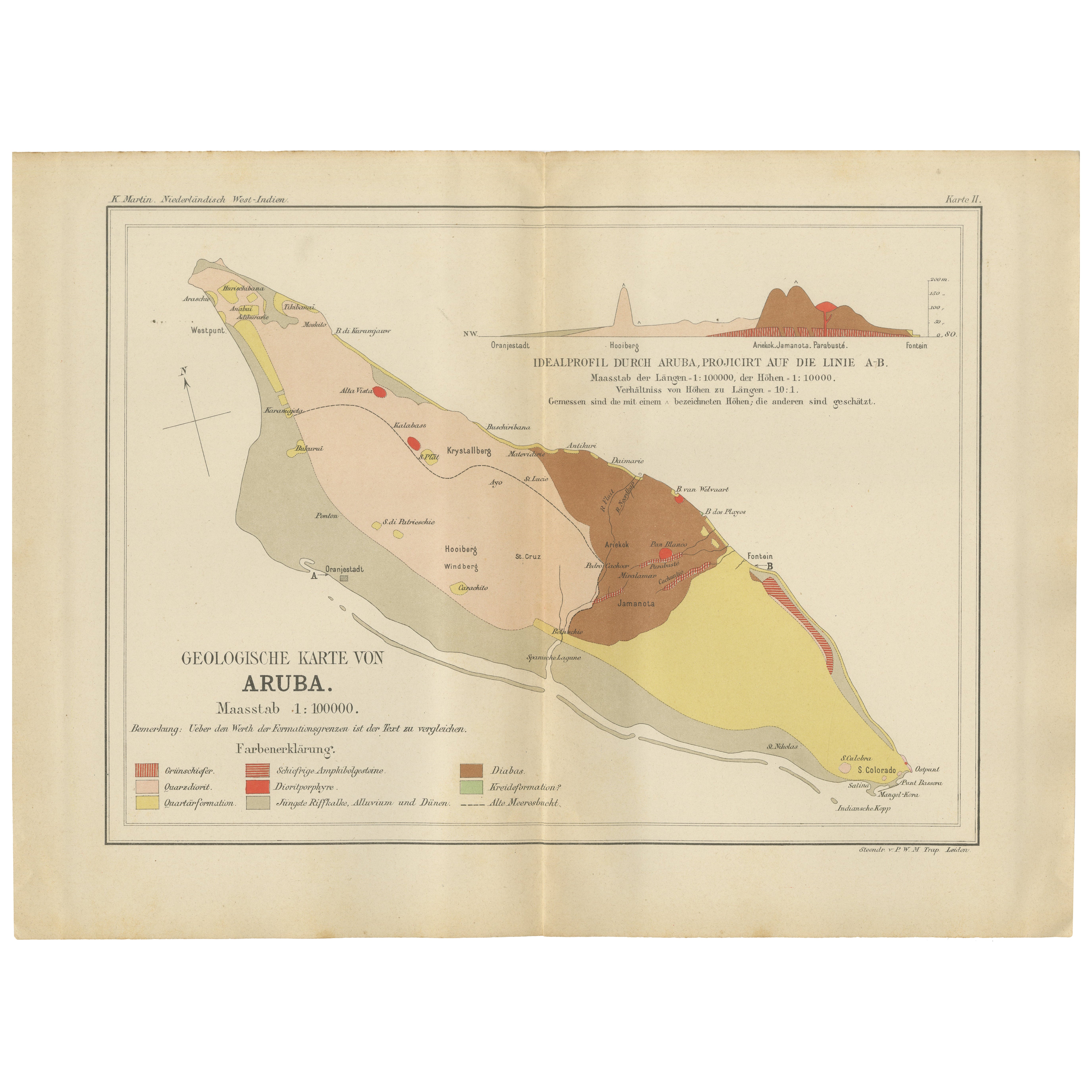
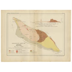
View AllAntique Geological Map of Aruba - Dutch West Indies by Karl Martin, 1888
Located in Langweer, NL
Geological Map of Aruba 1888 Dutch West Indies by Karl Martin
This finely detailed geological map of Aruba was published in 1888 as part of Karl Martin’s authoritative scientific st...
Category
Antique 1880s German Maps
Materials
Paper
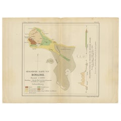
Geological Map of Bonaire - Dutch West Indies by Karl Martin, 1888
Located in Langweer, NL
Geological Map of Bonaire 1888 Dutch West Indies by Karl Martin
This finely executed geological map of Bonaire was published in 1888 as part of Karl Martin’s major scientific work B...
Category
Antique 1880s German Maps
Materials
Paper
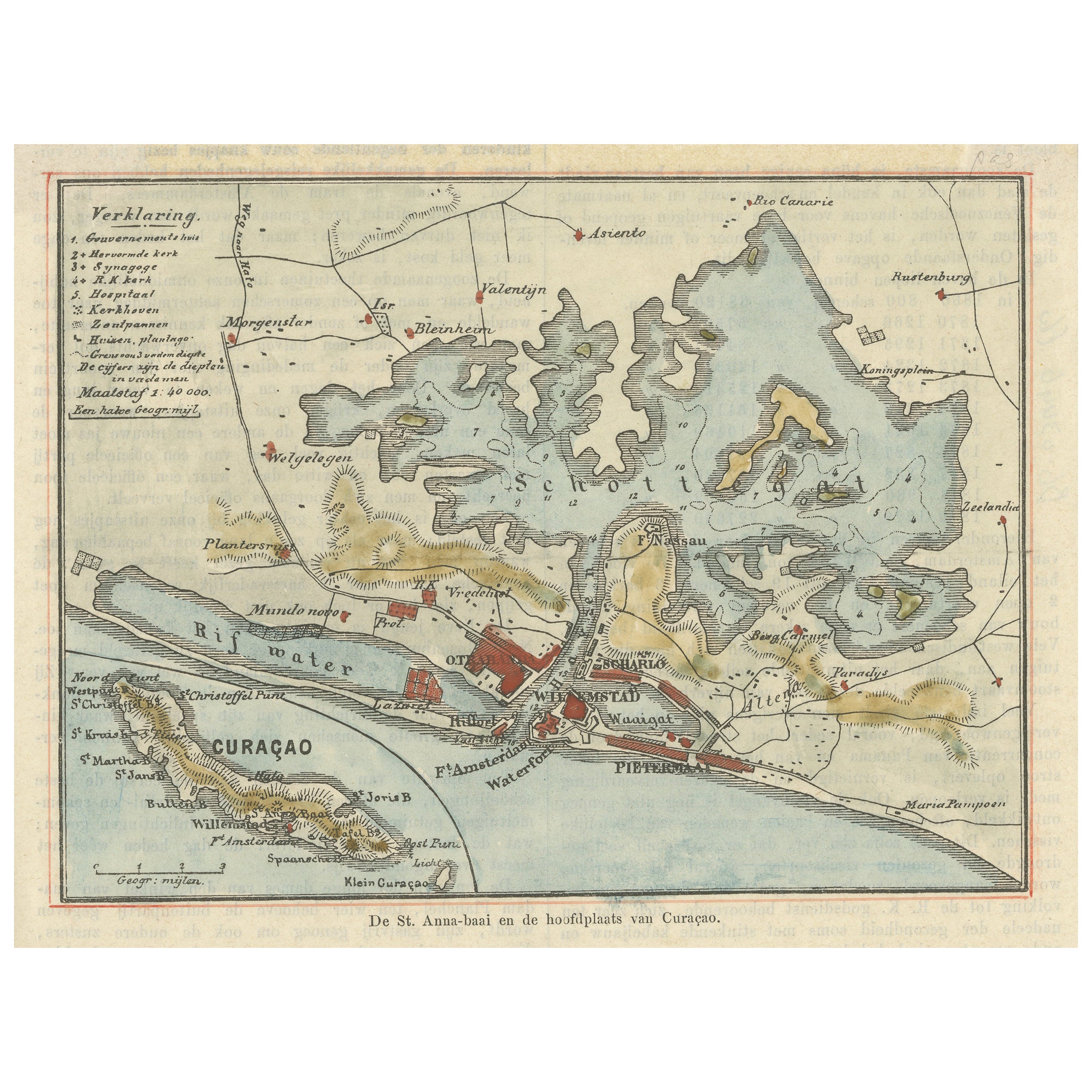
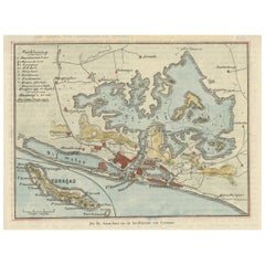
Small Map of St. Anna Bay and Willemstad, Curaçao – Dutch Colonial View, c. 1880
Located in Langweer, NL
Map of St. Anna Bay and Willemstad, Curaçao – Dutch Colonial View, c. 1880
This attractive late 19th-century map titled “De St. Anna-baai en de hoofdstad van Curaçao” offers a detai...
Category
Antique 1880s Maps
Materials
Paper
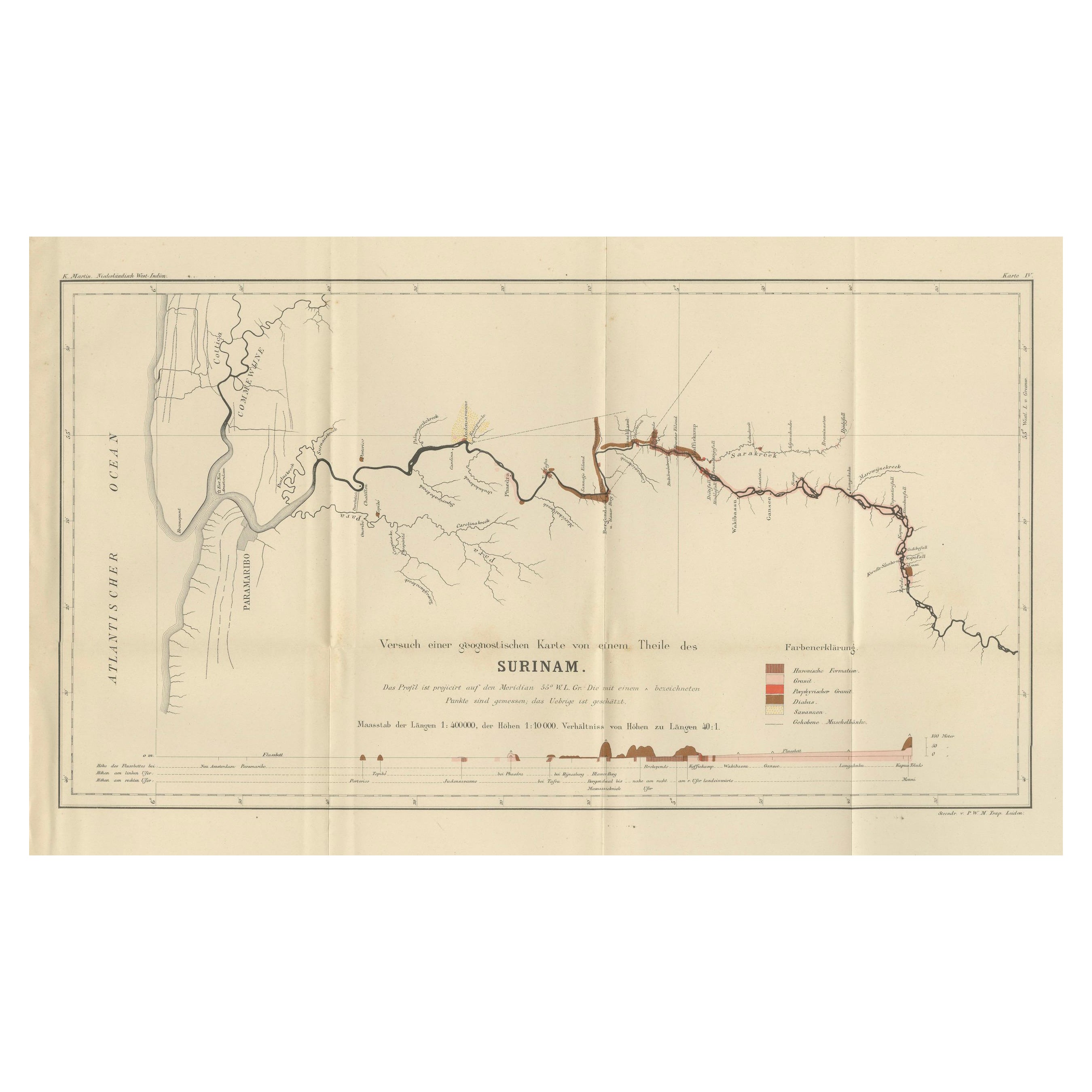
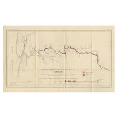
Antique Geological Survey Map of Surinam 1888 Hand Colored, Rare
Located in Langweer, NL
Antique Geological Survey Map of Surinam 1888 Hand Colored
This impressive hand-colored geological survey map of Surinam was published in 1888 as part of Karl Martin’s monumental sc...
Category
Antique 1880s German Maps
Materials
Paper
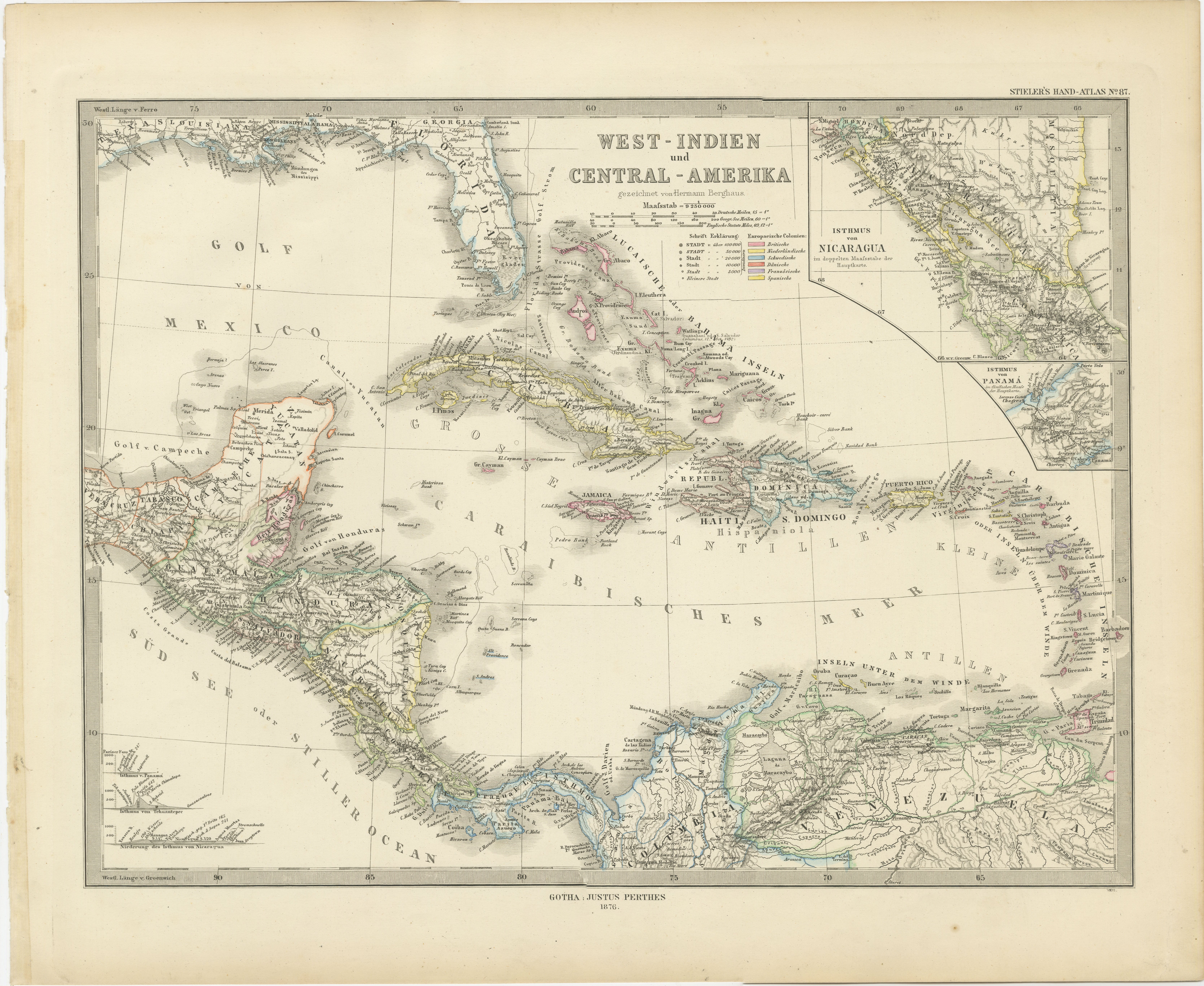
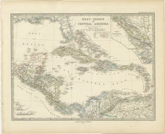
1880 Map of the Caribbean and Central America by Adolf Stieler
Located in Langweer, NL
This is a detailed map titled "West-Indien und Central-Amerika," created by Adolf Stieler and published in Gotha in 1880. The map covers the Caribbean islands and the Central America...
Category
Antique 1880s Maps
Materials
Paper
$275 Sale Price
20% Off
Antique Map of the West Indies and Central America by W. G. Blackie, 1859
Located in Langweer, NL
Antique map titled 'The West India Island & Central America'. Original antique map of the West Indies and Central America, with inset map of Jamaica. Th...
Category
Antique Mid-19th Century Maps
Materials
Paper

$237 Sale Price
20% Off
You May Also Like
Large Original Antique Map of The Leeward Islands. 1894
Located in St Annes, Lancashire
Superb Antique map of The Leeward Islands
Published Edward Stanford, Charing Cross, London 1894
Original colour
Good condition
Unframed.
Free shipping
Category
Antique 1890s English Maps
Materials
Paper

Large Original Antique Map of The Canary Islands. 1894
Located in St Annes, Lancashire
Superb Antique map of The Canary Islands
Published Edward Stanford, Charing Cross, London 1894
Original colour
Good condition
Unframed.
Free shipping
Category
Antique 1890s English Maps
Materials
Paper

Large Original Antique Map of the The Windward Islands. 1894
Located in St Annes, Lancashire
Superb Antique map of The Windward Islands
Published Edward Stanford, Charing Cross, London 1894
Original colour
Good condition
Unframed.
Free shipping
Category
Antique 1890s English Maps
Materials
Paper

Large Original Antique Map of The West Indies by Sidney Hall, 1847
Located in St Annes, Lancashire
Great map of The West Indies
Drawn and engraved by Sidney Hall
Steel engraving
Original colour outline
Published by A & C Black. 1847
Unframed
Free shipping.
Category
Antique 1840s Scottish Maps
Materials
Paper

Original Antique Map of Central America / Florida, Arrowsmith, 1820
Located in St Annes, Lancashire
Great map of Central America.
Drawn under the direction of Arrowsmith.
Copper-plate engraving.
Published by Longman, Hurst, Rees, Orme and Brown, 1820
Unframed.
Category
Antique 1820s English Maps
Materials
Paper

Curaçao map - C. van Baarsel en zoon
Located in UTRECHT, UT
“Kaart van het eiland Curaçao.”, “Algemeene kaart der Caraïbische eilanden”, “Plan van het fort Amsterdam op Curaçao” from the atlas “Atlas der overzeesche bezittingen van Zijne Maje...
Category
Antique 1810s Dutch Other Maps
Materials
Paper