Items Similar to Antique Hand-Colored Map of Lozère, France – Alexandre Vuillemin, 19th Century


Want more images or videos?
Request additional images or videos from the seller
1 of 11
Antique Hand-Colored Map of Lozère, France – Alexandre Vuillemin, 19th Century
$264.42
£195.86
€220
CA$361.71
A$394.25
CHF 208.44
MX$4,746.03
NOK 2,645.58
SEK 2,425.46
DKK 1,676.28
About the Item
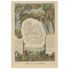
Antique Map of Lozère, France – Vuillemin
Levasseur, Mid-19th Century
This finely detailed map of the department of Lozère in southern France was created by Alexandre Vuillemin and engraved by Levasseur, as part of the mid-19th century series La France. It presents a rich and decorative composition, combining geographic precision with artistic flourishes.
The map outlines the department in yellow, showing its rivers, towns, villages, and road networks, with elevations subtly rendered to reflect the mountainous terrain of the Cévennes. The vignette scenes add cultural depth: a rural figure in traditional attire, a portrait of Chaptal (chemist and statesman born in Saint-Pierre-de-Nogaret), the Pont Gothique, and pastoral scenery including sheep grazing.
The area is especially known for its natural beauty, chestnut forests, and historical isolation, making this map a valuable reference for collectors, historians, and Francophiles.
Fifty Notable Places on the Map of Lozère:
1. Mende
2. Marvejols
3. Florac
4. Langogne
5. Le Bleymard
6. Bagnols-les-Bains
7. Le Pont-de-Montvert
8. Saint-Chély-d’Apcher
9. Villefort
10. Chanac
11. Aumont-Aubrac
12. La Canourgue
13. Saint-Alban
14. Sainte-Enimie
15. Saint-Germain-du-Teil
16. Chirac
17. Javols
18. Saint-Laurent-de-Trèves
19. Ispagnac
20. Meyrueis
21. Le Malzieu
22. Rieutort-de-Randon
23. Saint-Bauzile
24. Barjac
25. Cubières
26. Le Collet-de-Dèze
27. Saint-Étienne-du-Valdonnez
28. Les Salelles
29. Le Rozier
30. Le Recoux
31. Saint-Bonnet-de-Montauroux
32. Nasbinals
33. Chasseradès
34. Le Masgros
35. Le Chayla-d'Ance
36. Saint-Frézal-d'Albuges
37. Vialas
38. Moissac-Vallée-Française
39. Bédouès
40. Saint-Julien-du-Tournel
41. Prunières
42. Esclanèdes
43. Saint-Georges-de-Lévéjac
44. Le Buisson
45. Les Hermaux
46. Servières
47. Le Born
48. Saint-Alban-sur-Limagnole
49. Saint-Sauveur-de-Ginestoux
50. Arzenc-de-Randon
Condition Report:
Very good condition with wide margins. Minor age-related toning to the paper edges. Visible plate mark. No tears or repairs. Crisp original outline hand-coloring.
Framing Suggestions:
A frame in natural wood or gold with a double mat—ivory with a subtle ochre or mustard inner line—would highlight the rich topography and historical figures. Ideal for display in a study, hallway, or wine lounge.
Technique: Engraving with original hand coloring
Maker: A. Vuillemin (map), Levasseur (engraver), France, c. 1840s–1850s
- Dimensions:Height: 12.8 in (32.5 cm)Width: 10.28 in (26.1 cm)Depth: 0.01 in (0.2 mm)
- Materials and Techniques:Paper,Engraved
- Place of Origin:
- Period:
- Date of Manufacture:circa 1850
- Condition:Very good condition with wide margins. Minor age-related toning to the paper edges. Visible plate mark. No tears or repairs. Crisp original outline hand-coloring.
- Seller Location:Langweer, NL
- Reference Number:Seller: BG-13331-471stDibs: LU3054347401552
About the Seller
5.0
Recognized Seller
These prestigious sellers are industry leaders and represent the highest echelon for item quality and design.
Platinum Seller
Premium sellers with a 4.7+ rating and 24-hour response times
Established in 2009
1stDibs seller since 2017
2,813 sales on 1stDibs
Typical response time: 1 hour
- ShippingRetrieving quote...Shipping from: Langweer, Netherlands
- Return Policy
More From This Seller
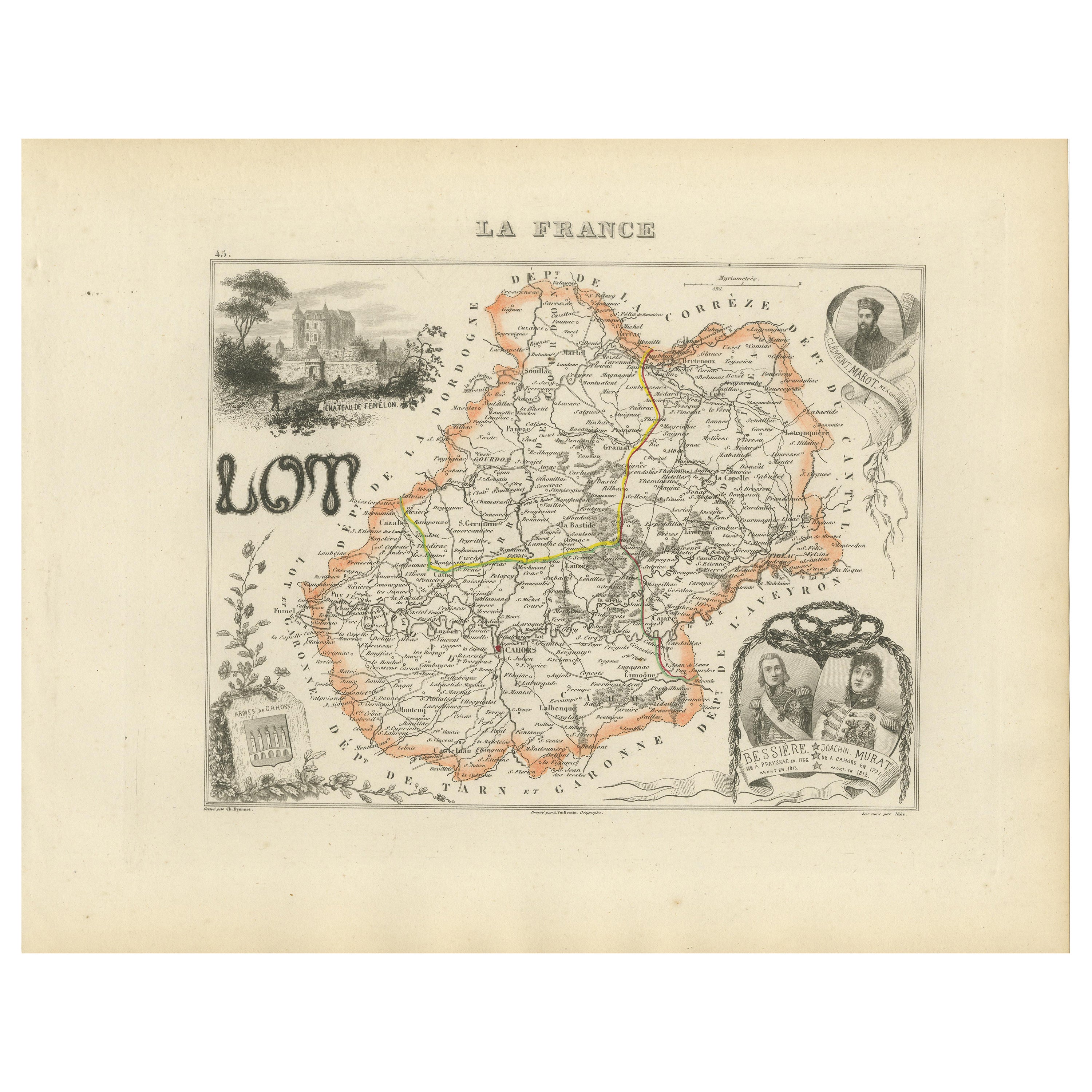
View AllAntique Map of Lot, France – Hand-Colored Engraving by Vuillemin, c.1850
Located in Langweer, NL
Antique Map of Lot, France – Hand-Colored Engraving by Vuillemin, c.1850
This beautifully engraved 19th-century map of the French department of Lot was created by the notable French...
Category
Antique Mid-19th Century French Maps
Materials
Paper
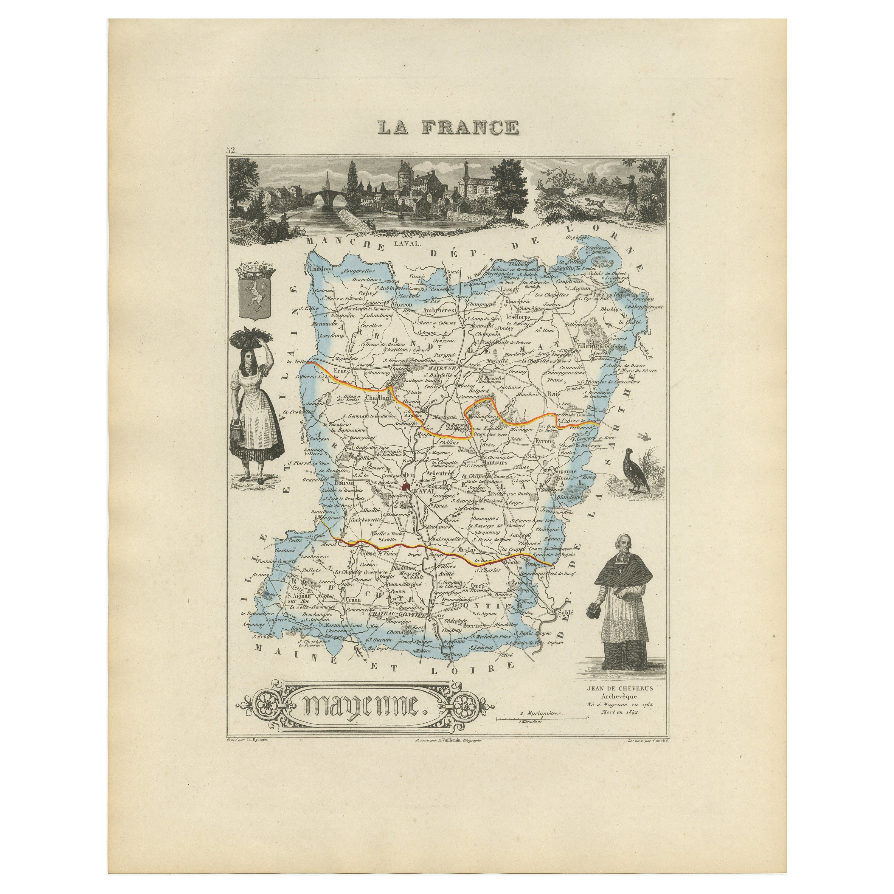
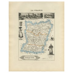
Antique Map of Mayenne – Hand-Colored Engraving by Levasseur, France c.1850
Located in Langweer, NL
Antique Map of Mayenne – Hand-Colored Engraving by Levasseur, France c.1850
This finely detailed 19th-century engraved map of the department of Mayenne in northwestern France was cr...
Category
Antique Mid-19th Century French Maps
Materials
Paper
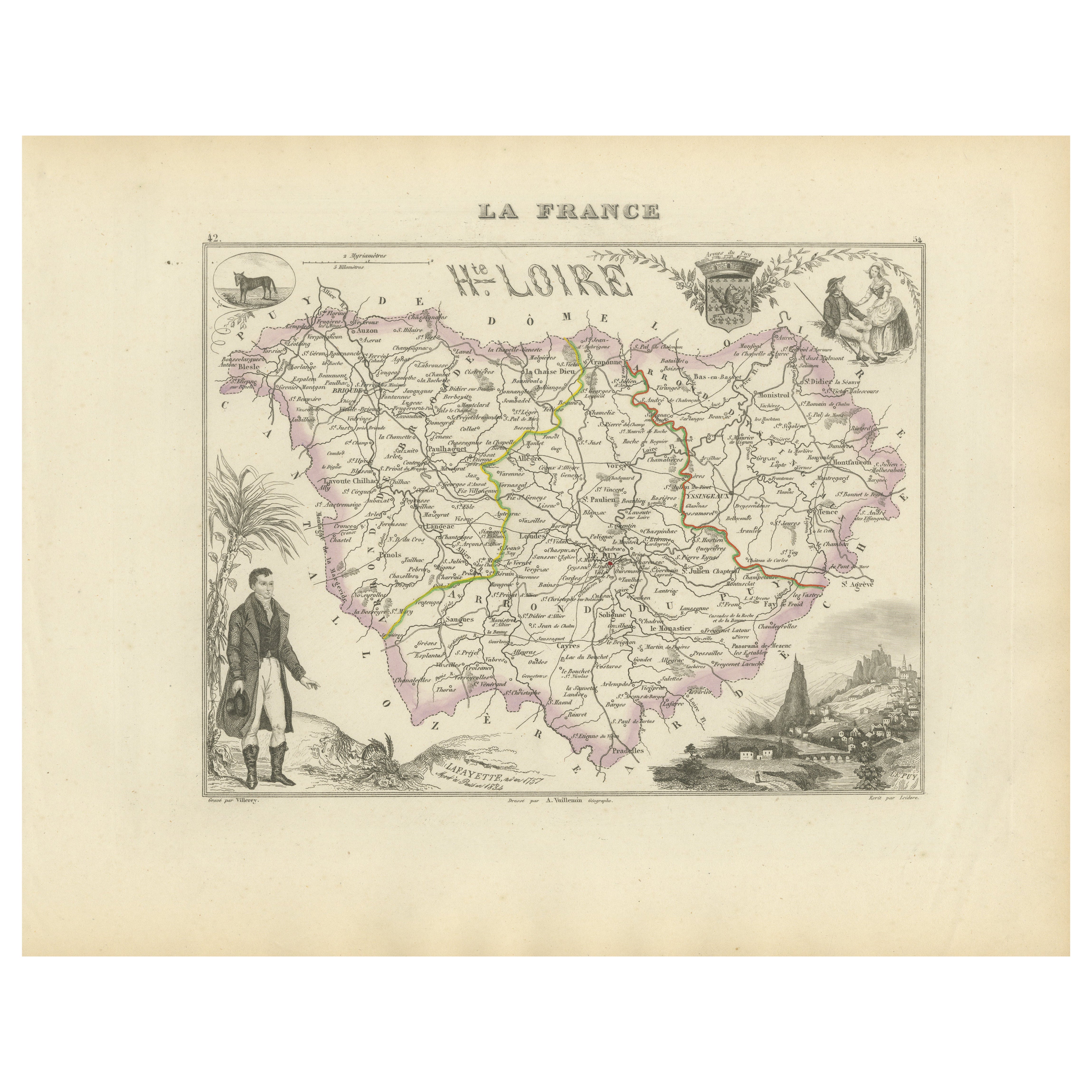
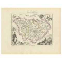
Map of Haute-Loire France with Le Puy-en-Velay by Vuillemin, 19th c
Located in Langweer, NL
Map of Haute-Loire France with Le Puy-en-Velay by Vuillemin, 19th c
This 19th-century hand-colored map of the Haute-Loire department in south-central France is from Alexandre Vuille...
Category
Antique Mid-19th Century French Maps
Materials
Paper
Map of Loire France with Saint-Étienne and Montbrison by Vuillemin, 19th c
Located in Langweer, NL
Map of Loire France with Saint-Étienne and Montbrison by Vuillemin, 19th c
This beautifully engraved and hand-colored map of the department of Loire in east-central France is from t...
Category
Antique Mid-19th Century French Maps
Materials
Paper

Hand Colored Antique Map of the department of Lozere, France
By Victor Levasseur
Located in Langweer, NL
Antique map titled 'Dept. de la Lozère'. Map of the French department of Lozere, France. This remote mountainous part of Languedoc is rural, sparcely populated, and extremely beautif...
Category
Antique Mid-19th Century Maps
Materials
Paper
$326 Sale Price
20% Off
Antique French Map of Ille-et-Vilaine Region with Rennes, Saint-Malo, 1800s
Located in Langweer, NL
Antique Map of Ille-et-Vilaine, France by Vuillemin, 19th Century
This decorative antique map presents the French département of Ille-et-Vilaine, situated in the Brittany region of ...
Category
Antique Mid-19th Century French Maps
Materials
Paper

You May Also Like
Lozere, France. Antique map of a French department, 1856
By Victor Levasseur
Located in Melbourne, Victoria
'Dept. de La Lozere', steel engraving with original outline hand-colouring., 1856, from Levasseur's 'Atlas National Illustre'.
This remote mountainous part of Languedoc is rural, s...
Category
19th Century Naturalistic Landscape Prints
Materials
Engraving

L
Isere, France. Antique map of French department, 1856
By Victor Levasseur
Located in Melbourne, Victoria
'Dept. de L'Isere', Steel engraving with original outline hand-colouring., 1856, from Levasseur's 'Atlas National Illustre'.
This area is known for its production of Bleu du Vercor...
Category
19th Century Naturalistic Landscape Prints
Materials
Engraving

Beautiful Colour French Antique 1856 Hand Watercolour Map of Dept Des La Corse
Located in West Sussex, Pulborough
We are delighted to offer for sale this stunning 1856 hand watercolour map of the Austrian Alps titled Dept Des La Course taken from the Atlas National ...
Category
Antique 1850s French Early Victorian Maps
Materials
Paper

Jura, France. Antique map of a French department, 1856
By Victor Levasseur
Located in Melbourne, Victoria
'Dept. du Jura', steel engraving with original outline hand-colouring., 1856, from Levasseur's 'Atlas National Illustre'.
The Jura wines are very distinctive and unusual, such as V...
Category
19th Century Naturalistic Landscape Prints
Materials
Engraving

Aude, France. Antique map of a French department, 1856
By Victor Levasseur
Located in Melbourne, Victoria
'Dept. de L' Aude', steel engraving with original outline hand-colouring., 1856, from Levasseur's 'Atlas National Illustre'.
This area of France is famous for its wide variety of v...
Category
19th Century Naturalistic Landscape Prints
Materials
Engraving

Aube, France. Antique map of a French department, 1856
By Victor Levasseur
Located in Melbourne, Victoria
'Dept. de L'Aube', steel engraving with original outline hand-colouring., 1856, from Levasseur's 'Atlas National Illustre'.
This area of France is known for its production of Chaou...
Category
19th Century Naturalistic Landscape Prints
Materials
Engraving
