Items Similar to Antique Holy Land Map, Twelve Tribes of Israel – Covens
Mortier, c.1700


Want more images or videos?
Request additional images or videos from the seller
1 of 10
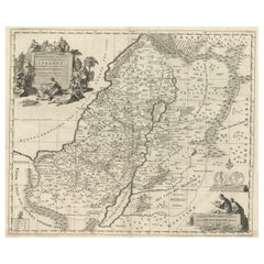
Antique Holy Land Map, Twelve Tribes of Israel – Covens
Mortier, c.1700
$1,442.28
£1,068.34
€1,200
CA$1,972.99
A$2,150.46
CHF 1,136.93
MX$25,887.43
NOK 14,430.45
SEK 13,229.77
DKK 9,143.34
About the Item
Antique Holy Land Map, Twelve Tribes of Israel – Covens
Mortier, c.1700
Description:
This finely engraved early 18th-century map depicts the Holy Land divided according to the Twelve Tribes of Israel. Titled Het Heylige Land verdeeld in de Twaalf Stammen Israëls, it presents biblical Palestine as understood through scripture and classical sources, rather than as a contemporary political geography. The map was published in Amsterdam around 1700 by the renowned firm Covens
Mortier and engraved by Johannes van Luchtenburgh.
The territories of the Twelve Tribes are clearly defined and densely labeled, covering Judaea, Samaria, Galilee, and Transjordan. Major biblical landmarks such as the Jordan River, the Dead Sea, and the Sea of Galilee structure the composition, while surrounding regions including Arabia, Phoenicia, and parts of Egypt provide geographical context. Mountains, rivers, settlements, and place names associated with Old Testament history are carefully engraved throughout, making the map both informative and visually rich.
Decorative engraving enhances the map’s devotional and scholarly character. An elaborate allegorical cartouche at upper left shows biblical figures gathered around the Tablets of the Law, emphasizing the sacred foundation of the subject. At lower right, a seated scholar engaged in study reinforces the map’s role as a tool for biblical learning and interpretation. These elements reflect the strong Protestant interest in biblical geography in Northern Europe around 1700, when such maps were widely used for teaching, study, and display.
Produced to a high standard typical of Dutch mapmaking at the turn of the 18th century, this map balances detailed scholarship with restrained ornament. It was intended not for navigation, but for theological reference and visualizing scripture, and today it remains highly desirable among collectors of Holy Land maps, biblical cartography, and early Dutch engravings.
Condition report:
Good overall condition with a strong, clear impression. Light age toning and minor surface wear consistent with age. Margins present.
Framing tips:
This map frames beautifully in a classic black or dark walnut frame with an ivory or parchment-colored mat to emphasize the fine engraving. A slightly wider mat allows the decorative cartouches to breathe and enhances the map’s presence as a wall piece.
Technique: engraving
Maker: Johannes van Luchtenburgh, Netherlands (published by Covens
Mortier, Amsterdam, c.1700)
- Dimensions:Height: 15.75 in (40 cm)Width: 18.51 in (47 cm)Depth: 0.01 in (0.2 mm)
- Materials and Techniques:Paper,Engraved
- Place of Origin:
- Period:
- Date of Manufacture:circa 1700
- Condition:Good overall condition with a strong, clear impression. Light age toning and minor surface wear consistent with age. Margins present.
- Seller Location:Langweer, NL
- Reference Number:Seller: BG-14152-11stDibs: LU3054348068952
About the Seller
5.0
Recognized Seller
These prestigious sellers are industry leaders and represent the highest echelon for item quality and design.
Platinum Seller
Premium sellers with a 4.7+ rating and 24-hour response times
Established in 2009
1stDibs seller since 2017
2,811 sales on 1stDibs
Typical response time: 1 hour
- ShippingRetrieving quote...Shipping from: Langweer, Netherlands
- Return Policy
More From This Seller
View AllAntique French Map of the Holy Land, Twelve Tribes of Israel, c.1750
Located in Langweer, NL
Antique Holy Land Map, Twelve Tribes of Israel – Robert de Vaugondy, c.1750
Description
This finely engraved and hand-colored map depicts Judea, or the Holy Land, divided according ...
Category
Antique Mid-18th Century French Maps
Materials
Paper
Highly Detailed Antique Map of the Holy Land Showing 12 Tribes of Israel, c.1720
Located in Langweer, NL
Antique map titled 'Heylige Land verdeeld in de Twaalf Stammen Israels (..).'
Highly detailed map of the Holy Land divided into 12 tribes of Israel...
Category
Antique 1720s Maps
Materials
Paper

$461 Sale Price
20% Off
Free Shipping
Holy Land Map of the Twelve Tribes of Israel, After Sanson, Paris c.1798
Located in Langweer, NL
Holy Land, Twelve Tribes of Israel – After Nicolas Sanson, De Vaugondy / Delamarche, c.1798
Description:
Holy Land. De Vaugondy (G. R.), Carte de la Terre des Hébreux ou Israélites,...
Category
Antique Late 18th Century French Maps
Materials
Paper

Map of the Holy Land Divided into 12 Tribes, the Travels of Jesus Christ, 1700
Located in Langweer, NL
Antique map titled 'Het Heylige Land verdeeld in de Twaalf Stammen Israels (..)'.
Decorative and detailed map of the Holy Land divided into 12 Tribes, sh...
Category
Antique Early 1700s Maps
Materials
Paper
$471 Sale Price
20% Off
Judaea or Terra Sancta, Twelve Tribes of Israel – Sanson Map, c.1680
Located in Langweer, NL
Judaea or Terra Sancta, Twelve Tribes of Israel – Sanson Map, c.1680
This antique map depicts Judaea or the Holy Land divided among the Twelve Tribes of Israel, based on biblical ge...
Category
Antique Late 17th Century Dutch Maps
Materials
Paper
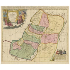
Antique Map of the Holy Land by Van Luchtenburg, c.1720
Located in Langweer, NL
Antique map titled 'Heylige Land verdeeld in de Twaalf Stammen Israels (..).' Highly detailed map of the Holy Land divided into 12 tribes of Israel...
Category
Antique 18th Century Maps
Materials
Paper

You May Also Like
Map Holy Land La Terre Sainte Engraved van Loon Published N de Fer 1703 French
Located in BUNGAY, SUFFOLK
La Terre Sainte, The Holy Land, Tiree Des Memoires De M.De.La Rue. Par N. de Fer. Geographe de Sa Majeste Catoliq et de Monseigneur le Dauphin. Avec Privil du Roi 1703
Detailed map of the Holy Land from Nicholas de Fer's L'Atlas Curieux ou le Monde. East is oriented at the top.
MAKER Nicolas de Fer 1646-1720
The French cartographer and engraver, Nicolas de Fer, was a master at creating maps that were works of art. The maps that he published were printed during the Baroque period when the decorative arts were characterized by ornate detail. De Fer’s detailed maps and atlases were valued more for their decorative content than their geographical accuracy.
Nicolas de Fer was born in 1646. His father, Antoine de Fer, owned a mapmaking firm. At the age of twelve, Nicolas was apprenticed to a Parisian engraver named Louis Spirinx. The family business was starting to decline when his father died in 1673. Nicolas de Fer’s mother, Genevieve, took over the business after the death of her husband. In 1687 the business was passed on to Nicolas and the profits increased after he took over the firm. Nicolas de Fer was a prolific cartographer who produced atlases and hundreds of single maps. He eventually became the official geographer to King Louis XIV of France and King Philip V...
Category
Antique Early 1700s French Louis XIV Maps
Materials
Paper

1657 Janssonius Map of Vermandois and Cappelle, Ric. A-004
Located in Norton, MA
1657 Janssonius map of
Vermandois and Cappelle
Ric.a004
Description: Antique map of France titled 'Descriptio Veromanduorum - Gouvernement de la Cappelle'. Two detailed maps o...
Category
Antique 17th Century Unknown Maps
Materials
Paper

17th Century Dutch Map of the Holy Land at the Time of Jesus by Visscher
By Nicolaus Visscher
Located in Alamo, CA
This detailed Dutch map entitled "Het Beloofe de Landt Canaan door wandelt van onsen Salichmaecker Iesu Christo, nessens syne Apostelen" by Nicolaes Visscher (1610-1679), published i...
Category
1660s Prints and Multiples
Materials
Engraving

$1,020 Sale Price
20% Off
"Nova Barbariae Descriptio", a 17th Century Hand-Colored Map of North Africa
By Johannes Janssonius
Located in Alamo, CA
This original attractive 17th century hand-colored map of North Africa entitled "Nova Barbariae Descriptio" by Johannes Janssonius was published in Paris in 1635. It includes the Med...
Category
Antique Mid-17th Century Dutch Maps
Materials
Paper

$1,020 Sale Price
20% Off
1714 Henri Chatelain "Nouvelle Carte Des Etatas Du Grand.Duc De Mos Moscovie Eur
Located in Norton, MA
A 1714 Henri Chatelain map, entitled
"Nouvelle Carte Des Etatas Du Grand Duc De Moscovie En Europe,"
Ricb001
Henri Abraham Chatelain (1684-1743) was a Huguenot pastor of Parisi...
Category
Antique Early 18th Century Dutch Maps
Materials
Paper

1640 Joan Bleau Map Entitled"Diocecese de rheims et le pais de rethel, " Eic.a011
Located in Norton, MA
1640 Joan Bleau map entitled
"Diocecese de rheims et le pais de rethel,"
Ric.a011
OAN BLAEU
Diocecese de Rheims, et le pais de Rethel.
Handcolored engraving, c.1640.
...
Category
Antique 17th Century Dutch Maps
Materials
Paper
