Want more images or videos?
Request additional images or videos from the seller
1 of 11
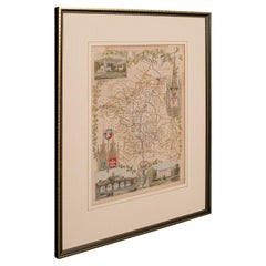
Antique Lithography Map, Isle of Wight, English, Framed, Engraving, Cartography
$703.73List Price
About the Item
- Dimensions:Height: 13.59 in (34.5 cm)Width: 15.56 in (39.5 cm)Depth: 0.6 in (1.5 cm)
- Style:Regency (Of the Period)
- Materials and Techniques:
- Place of Origin:
- Period:
- Date of Manufacture:circa 1820
- Condition:Wear consistent with age and use. Presented in very good antique condition.
- Seller Location:Hele, Devon, GB
- Reference Number:Seller: 240191stDibs: LU2645338433132
About the Seller
5.0
Platinum Seller
Premium sellers with a 4.7+ rating and 24-hour response times
Established in 2005
1stDibs seller since 2017
1,088 sales on 1stDibs
Authenticity Guarantee
In the unlikely event there’s an issue with an item’s authenticity, contact us within 1 year for a full refund. DetailsMoney-Back Guarantee
If your item is not as described, is damaged in transit, or does not arrive, contact us within 7 days for a full refund. Details24-Hour Cancellation
You have a 24-hour grace period in which to reconsider your purchase, with no questions asked.Vetted Professional Sellers
Our world-class sellers must adhere to strict standards for service and quality, maintaining the integrity of our listings.Price-Match Guarantee
If you find that a seller listed the same item for a lower price elsewhere, we’ll match it.Trusted Global Delivery
Our best-in-class carrier network provides specialized shipping options worldwide, including custom delivery.You May Also Like
Antique Map of the Northeast USA - Vibrant 1903 Cartographic Detail
Located in Langweer, NL
Map of the Northeastern United States of North America, 1903
This striking antique map titled “United States of North America (North Eastern Sheet)” was created by the renowned Scot...
Category
Early 20th Century Maps
Materials
Paper
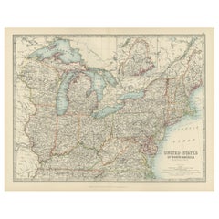
$408
H 14.49 in W 18.51 in D 0.01 in
1584 Ortelius Map of Switzerland: A Cartographic Reversal
Located in Langweer, NL
This is a fine example of Ortelius' map of Switzerland from his *Theatrum Orbis Terrarum*, recognized as the first modern atlas of the world. The map is oriented with south at the top, which reverses the typical north-up orientation seen in most modern maps. It highlights significant geographical features such as Lake Geneva (Lemanus Lacus) to the right of the map and the Rhine river entering Switzerland near the center.
The *Theatrum Orbis Terrarum*, first published in 1570 by Abraham Ortelius in Antwerp, was groundbreaking as it compiled uniform maps with supporting text in a single volume, marking a departure from earlier collections of maps that were custom-assembled on demand. This atlas included a wealth of sixteenth-century cartographic knowledge, reflecting the extensive global explorations occurring after the discovery of America...
Category
Antique 16th Century Maps
Materials
Paper
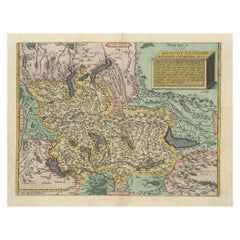
$924 Sale Price
30% Off
H 17.33 in W 21.46 in D 0 in
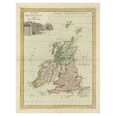
Antique Map of the British Isles by Lotter, 1764
Located in Langweer, NL
Antique map titled 'Le Grand Bretagne ou les Royaumes d'Angleterre et d'Ecosse'. Old engraved map of the British Isles (main islands United Kingdom & Ire...
Category
Antique 18th Century Maps
Materials
Paper
Antique Map of the British Isles by Balbi
1847
Located in Langweer, NL
Antique map titled 'Iles Britanniques'. Original antique map of the British Isles. This map originates from 'Abrégé de Géographie (..)' by Adrien Balbi. ...
Category
Antique Mid-19th Century Maps
Materials
Paper

Antique Map of the British Isles by Johnston
1909
Located in Langweer, NL
Antique map titled 'The British Isles'. Original antique map of the British Isles. With inset maps of the Shetland Islands, Chanel Islands, and London. T...
Category
Early 20th Century Maps
Materials
Paper
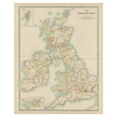
$240 Sale Price
20% Off
H 24.41 in W 19.49 in D 0.02 in
Antique Map of the British Isles by Delamarche, 1806
Located in Langweer, NL
Antique map titled 'Les Isles Britanniques.' Decorative map of the British Isles by Robert de Vaugondy, revised and published by Delamarche. Source unkno...
Category
Antique 19th Century Maps
Materials
Paper

$144 Sale Price
20% Off
H 11.3 in W 14.65 in D 0 in
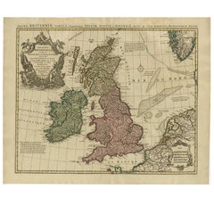
Antique Map of the British Isles by H. Chatelain, 1719
By Henri-Abraham Chatelain
Located in Langweer, NL
Beautiful hand colored large format map of the British Isles, with large insets of the Eastern and Western Hemispheres and the coats of arms for Engl...
Category
Antique Early 18th Century Maps
Materials
Paper

Antique Map of the British Isles with Contemporary Hand Coloring
Located in Langweer, NL
Antique map titled 'Les Isles Britanniques'. Original antique map of the British Isles, with original/contemporary hand coloring. Published by Crepe, circa 1767.
Category
Antique Late 18th Century Maps
Materials
Paper
$269 Sale Price
20% Off
H 12.52 in W 9.73 in D 0.02 in
Original Antique Map of the British Isles Surrounded by Text
Located in Langweer, NL
Antique map titled 'Des Isles Britanniques'. Original antique map of the British isles. This map is divided in to three major regions of the 18th century United Kingdom: England, Ire...
Category
Antique Late 18th Century Maps
Materials
Paper

$355 Sale Price
20% Off
H 16.54 in W 23.71 in D 0.02 in
Antique Map of the British Isles by Covens
Mortier, 1730
By Covens
Mortier
Located in Langweer, NL
Covens and Mortier's attractive double-page engraved map of the British Isles, based on the 1702 De L'Isle map. The map features a large car...
Category
Antique Mid-18th Century Maps
Materials
Paper
$624 Sale Price
20% Off
H 20.87 in W 25.79 in D 0.02 in
More From This Seller
View AllAntique Lithography Map, Worcestershire, English, Framed Engraving, Cartography
Located in Hele, Devon, GB
This is an antique lithography map of Worcestershire. An English, framed atlas engraving of cartographic interest, dating to the early 19th centur...
Category
Antique Early 19th Century British Regency Maps
Materials
Wood
Antique Lithography Map, Bedfordshire, English, Framed Engraving, Cartography
Located in Hele, Devon, GB
This is an antique lithography map of Bedfordshire. An English, framed atlas engraving of cartographic interest, dating to the mid 19th century and...
Category
Antique Mid-19th Century British Victorian Maps
Materials
Wood

Antique Lithography Map, Northumberland, English, Framed, Engraving, Cartography
Located in Hele, Devon, GB
This is an antique lithography map of Northumberland. An English, framed atlas engraving of cartographic interest, dating to the mid 19th century a...
Category
Antique Mid-19th Century British Victorian Maps
Materials
Wood

Antique Lithography Map, Hertfordshire, English, Framed Engraving, Cartography
Located in Hele, Devon, GB
This is an antique lithography map of Hertfordshire. An English, framed atlas engraving of cartographic interest, dating to the mid 19th century an...
Category
Antique Mid-19th Century British Victorian Maps
Materials
Wood

Antique Lithography Map, Gloucestershire, English, Framed Engraving, Cartography
Located in Hele, Devon, GB
This is an antique lithography map of Gloucestershire. An English, framed atlas engraving of cartographic interest, dating to the mid 19th century ...
Category
Antique Mid-19th Century British Victorian Maps
Materials
Wood

Antique Lithography Map, Isle of Thanet, Kent, English, Cartography, Victorian
Located in Hele, Devon, GB
This is an antique lithography map of The Isle of Thanet in Kent. An English, framed atlas engraving of cartographic interest, dating to the mid 19th century and later.
Superb litho...
Category
Antique Mid-19th Century British Victorian Maps
Materials
Wood

Still Thinking About These?
All Recently ViewedMore Ways To Browse
19th Century Round Dining Table
Carved Chinese Tables
Mid Century Modern Danish Teak Dining Tables
Long Rug Runners
Pair Arm Chairs
Sterling Silver Dinner Sets
United Chair Company
British Antiques
Italian Beech Chairs
Shirvan Rugs
Spain Marble
Vintage Brown Bottles
Vintage Danish Tables And Chairs
1960s Glass Top Coffee Table
Black Glass Coffee Tables
Burnt Wood
Mid Century Wrought Iron Chairs
Earth Toned Rug