Want more images or videos?
Request additional images or videos from the seller
1 of 13
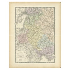
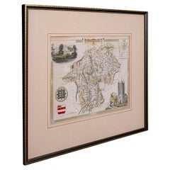
Antique Lithography Map, Western Russia, English, Framed, Cartography, Victorian
$855.30List Price
About the Item
- Dimensions:Height: 21.46 in (54.5 cm)Width: 17.33 in (44 cm)Depth: 0.6 in (1.5 cm)
- Style:Early Victorian (Of the Period)
- Materials and Techniques:
- Place of Origin:
- Period:
- Date of Manufacture:circa 1850
- Condition:Wear consistent with age and use. Presented in very good antique condition.
- Seller Location:Hele, Devon, GB
- Reference Number:Seller: 18.99951stDibs: LU2645338395572
About the Seller
5.0
Platinum Seller
Premium sellers with a 4.7+ rating and 24-hour response times
Established in 2005
1stDibs seller since 2017
1,091 sales on 1stDibs
Authenticity Guarantee
In the unlikely event there’s an issue with an item’s authenticity, contact us within 1 year for a full refund. DetailsMoney-Back Guarantee
If your item is not as described, is damaged in transit, or does not arrive, contact us within 7 days for a full refund. Details24-Hour Cancellation
You have a 24-hour grace period in which to reconsider your purchase, with no questions asked.Vetted Professional Sellers
Our world-class sellers must adhere to strict standards for service and quality, maintaining the integrity of our listings.Price-Match Guarantee
If you find that a seller listed the same item for a lower price elsewhere, we’ll match it.Trusted Global Delivery
Our best-in-class carrier network provides specialized shipping options worldwide, including custom delivery.You May Also Like
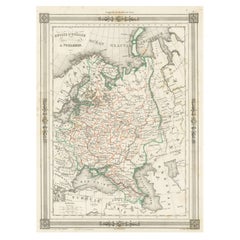
Antique Map of Western Russia by Levasseur,
1875
Located in Langweer, NL
Antique map titled 'Carte de la Russie Occidentale (..)'. Large map of Western Russia. This map originates from 'Atlas de Géographie Moderne Physique et Politique' by A. Levasseur. P...
Category
Antique Late 19th Century Maps
Materials
Paper
$332 Sale Price
20% Off
H 24.02 in W 18.71 in D 0.02 in
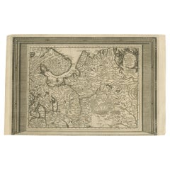
Antique Map of Western Russia by Covens
Mortier, 1740
Located in Langweer, NL
Antique map titled 'Carte de Moscovie'. Antique map of the western portion of Russia. The map centers on Moscow (shown near the top of the lower sheet) and spans from the Sea of Azov...
Category
Antique Mid-18th Century Maps
Materials
Paper

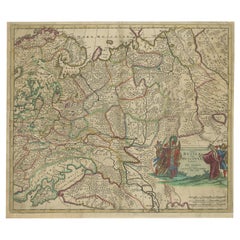
Antique Hand-Colored Map of Western Russia and Ukraine, c.1680
Located in Langweer, NL
Description: Antique map titled 'Novissima et Accuratissima Totius Russiae vulgo Muscoviae Tabula'.
Antique map of Western Russia and Ukraine, published by Justus Danckerts. The ma...
Category
Antique 1680s Dutch Maps
Materials
Paper
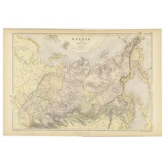
Detailed Antique Cartography of Asian Russia, 1882
Located in Langweer, NL
This exquisite map, hailing from the year 1882, is a remarkable historical cartographic artifact, which was included as part of the prestigious 'Comprehensive Atlas and Geography of ...
Category
Antique 1880s Maps
Materials
Paper
Antique Map of European Russia with Picture Frame Border
Located in Langweer, NL
Antique map titled 'La Moscovie Septentrionale (..)'. Decorative example of van der Aa's map of the northern part of European Russia. With the picture frame border, which appeared in...
Category
Antique Early 18th Century Maps
Materials
Paper
$360 Sale Price
20% Off
H 10.44 in W 16.54 in D 0.02 in
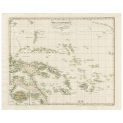
Antique Map of Western Polynesia, 1849
Located in Langweer, NL
Antique map titled 'Ost-Polynesien'. Detailed map of the western Pacific extending from the Celebes to Samoa and including part of Australia. Insets of...
Category
Antique Mid-19th Century Maps
Materials
Paper
Antique Map of Russia in Europe, with Frame Style Border
Located in Langweer, NL
Antique map titled 'Russie d'Europe'. Attractive map of Russia in Europe, covers the European portions of Russia from the Arctic Sea south to the Black Sea and Caspian Sea. This map ...
Category
Antique Mid-19th Century Maps
Materials
Paper
$123 Sale Price
20% Off
H 13.31 in W 10.12 in D 0.02 in
Antique Map of Western Tartary and the Gobi Desert of the Russian Empire, c.1750
Located in Langweer, NL
Antique map titled 'A Map of Western Tartary Drawn from the Survey of the Jesuits and Mr. Kyrillow's Map of the Russian Empire'. Map of the Gobi Desert and the eastern portion of the...
Category
Antique 18th Century Maps
Materials
Paper

$415
H 9.14 in W 15.08 in D 0 in
Western Africa Antique Map by W. G. Blackie, 1859
Located in Langweer, NL
The antique map titled 'Western Africa' presents an original depiction of the region. Originating from 'The Imperial Atlas of Modern Geography,' this map was published by W. G. Black...
Category
Antique Mid-19th Century Maps
Materials
Paper
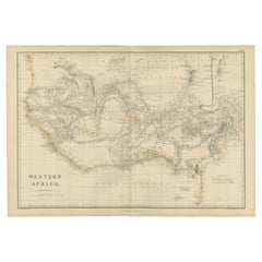
$237 Sale Price
20% Off
H 14.57 in W 21.26 in D 0.02 in
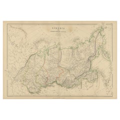
Antique Map of Siberia, Russia, 1859
Located in Langweer, NL
Antique map titled 'Siberia or Northern Asia'. Original antique map of Siberia or Northern Asia. This map originates from ‘The Imperial Atlas of Modern Geography’. Published by W. G....
Category
Antique Mid-19th Century Maps
Materials
Paper
More From This Seller
View AllAntique Lithography Map, Black Sea, English, Framed, Cartography, Victorian
Located in Hele, Devon, GB
This is an antique lithography map of the Black Sea region. An English, framed atlas engraving of cartographic interest by John Rapkin, dating to the early Victorian period and later...
Category
Antique Mid-19th Century British Early Victorian Maps
Materials
Wood

Antique Lithography Map, West Africa, English, Framed, Cartography, Victorian
Located in Hele, Devon, GB
This is an antique lithography map of Western Africa. An English, framed atlas engraving of cartographic interest by John Rapkin, dating to the early Victorian period and later, circ...
Category
Antique Mid-19th Century British Early Victorian Maps
Materials
Wood

Antique Lithography Map, South America, English, Framed, Cartography, Victorian
Located in Hele, Devon, GB
This is an antique lithography map of South America. An English, framed atlas engraving of cartographic interest by John Rapkin , dating to the early Victorian period and later, circ...
Category
Antique Mid-19th Century British Early Victorian Maps
Materials
Wood

Antique Lithography Map, Buckinghamshire, English, Framed Cartography, Victorian
Located in Hele, Devon, GB
This is an antique lithography map of Buckinghamshire. An English, framed atlas engraving of cartographic interest, dating to the mid 19th century and later.
Superb lithography of B...
Category
Antique Mid-19th Century British Victorian Maps
Materials
Wood, Paper

Antique Lithography Map, Westmoreland, English, Framed, Cartography, Victorian
Located in Hele, Devon, GB
This is an antique lithography map of Westmoreland. An English, framed atlas engraving of cartographic interest, dating to the mid 19th century and later.
Superb lithography of the ...
Category
Antique Mid-19th Century British Victorian Maps
Materials
Wood
Antique Lithography Map, Cumberland, English, Framed, Cartography, Victorian
Located in Hele, Devon, GB
This is an antique lithography map of Cumberland. An English, framed atlas engraving of cartographic interest, dating to the mid 19th century and la...
Category
Antique Mid-19th Century British Victorian Maps
Materials
Wood

Still Thinking About These?
All Recently ViewedMore Ways To Browse
19th Century Lithography
Russian Frame Antique
Russian Engraving
Antique Plate Germany
Side Table Made In Denmark
England Antique Plates
19th Century Round Dining Table
Antique Thrones
Carved Chinese Tables
Italian Ceramic 1960s
Mid Century Modern Danish Teak Dining Tables
Rosenthal Century
Long Rug Runners
Pair Arm Chairs
Sterling Silver Dinner Sets
United Chair Company
British Antiques
Italian Beech Chairs