Want more images or videos?
Request additional images or videos from the seller
1 of 5
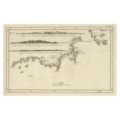
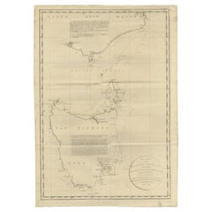
Antique Map of Adventure Bay, Van Diemens Land, Nowadays Tasmania Island, 1803
$379.70List Price
About the Item
- Dimensions:Height: 11.23 in (28.5 cm)Width: 9.65 in (24.5 cm)Depth: 0 in (0.01 mm)
- Materials and Techniques:
- Period:
- Date of Manufacture:1803
- Condition:
- Seller Location:Langweer, NL
- Reference Number:Seller: BG-11487-381stDibs: LU3054325991852
About the Seller
5.0
Recognized Seller
These prestigious sellers are industry leaders and represent the highest echelon for item quality and design.
Platinum Seller
Premium sellers with a 4.7+ rating and 24-hour response times
Established in 2009
1stDibs seller since 2017
2,836 sales on 1stDibs
Typical response time: 1 hour
Authenticity Guarantee
In the unlikely event there’s an issue with an item’s authenticity, contact us within 1 year for a full refund. DetailsMoney-Back Guarantee
If your item is not as described, is damaged in transit, or does not arrive, contact us within 7 days for a full refund. Details24-Hour Cancellation
You have a 24-hour grace period in which to reconsider your purchase, with no questions asked.Vetted Professional Sellers
Our world-class sellers must adhere to strict standards for service and quality, maintaining the integrity of our listings.Price-Match Guarantee
If you find that a seller listed the same item for a lower price elsewhere, we’ll match it.Trusted Global Delivery
Our best-in-class carrier network provides specialized shipping options worldwide, including custom delivery.You May Also Like
Antique Map of Principality of Monaco
By Antonio Vallardi Editore
Located in Alessandria, Piemonte
ST/619 - "Old Geographical Atlas of Italy - Topographic map of ex-Principality of Monaco" -
ediz Vallardi - Milano -
A somewhat special edition ---
Category
Antique Late 19th Century Italian Other Prints
Materials
Paper

The Holy Land at the Time of Jesus: A 17th Century Dutch Map by Visscher
By Nicolaes Visscher II
Located in Alamo, CA
This detailed Dutch map entitled "Het Beloofe de Landt Canaan door wandelt van onsen Salichmaecker Iesu Christo, nessens syne Apostelen" by Nicolaes Visscher was published in Amsterd...
Category
Antique Mid-17th Century Dutch Maps
Materials
Paper

$1,275
H 22.75 in W 28.5 in D 1.13 in
Original Antique Map of Europe, Arrowsmith, 1820
Located in St Annes, Lancashire
Great map of Europe
Drawn under the direction of Arrowsmith.
Copper-plate engraving.
Published by Longman, Hurst, Rees, Orme and Brown, 1820
...
Category
Antique 1820s English Maps
Materials
Paper

Original Antique Map of Hungary, Arrowsmith, 1820
Located in St Annes, Lancashire
Great map of Hungary
Drawn under the direction of Arrowsmith.
Copper-plate engraving.
Published by Longman, Hurst, Rees, Orme and Brown, 1820
Unframed.
Category
Antique 1820s English Maps
Materials
Paper

Original Antique Map of Ireland- Kerry. C.1840
Located in St Annes, Lancashire
Great map of Kerry
Steel engraving
Drawn under the direction of A.Adlard
Published by How and Parsons, C.1840
Unframed.
Category
Antique 1840s English Maps
Materials
Paper

Original Antique Map of China, Arrowsmith, 1820
Located in St Annes, Lancashire
Great map of China
Drawn under the direction of Arrowsmith
Copper-plate engraving
Published by Longman, Hurst, Rees, Orme and Brown, 1820
Unfr...
Category
Antique 1820s English Maps
Materials
Paper

Original Antique Map of South America. C.1780
Located in St Annes, Lancashire
Great map of South America
Copper-plate engraving
Published C.1780
Two small worm holes to left side of map
Unframed.
Category
Antique Early 1800s English Georgian Maps
Materials
Paper

Map of the Holy Land "Carte de la Syrie et de l
Egypte" by Pierre M. Lapie
By Pierre M. Lapie
Located in Alamo, CA
An early 19th century map of ancient Syria and Egypt entitled "Carte de la Syrie et de l'Egypte anciennes/dressée par M. Lapie, Colonel d'Etat Major, et...
Category
Antique Early 19th Century French Maps
Materials
Paper

$775
H 27 in W 21.38 in D 0.75 in
Hand-Colored 18th Century Homann Map of Denmark and Islands in the Baltic Sea
By Johann Baptist Homann
Located in Alamo, CA
An 18th century copper plate hand-colored map entitled "Insulae Danicae in Mari Balthico Sitae utpote Zeelandia, Fionia, Langelandia, Lalandia, Falstria, Fembria Mona" created by Joh...
Category
Antique Early 18th Century German Maps
Materials
Paper

$775
H 20.25 in W 23.25 in D 0.07 in
Original Antique Map of South Africa, Arrowsmith, 1820
Located in St Annes, Lancashire
Great map of South Africa.
Drawn under the direction of Arrowsmith.
Copper-plate engraving.
Published by Longman, Hurst, Rees, Orme and Br...
Category
Antique 1820s English Maps
Materials
Paper

More From This Seller
View AllAntique Coastal Views and a Map of Van Diemens Land (Tasmania), Australia, 1803
Located in Langweer, NL
Antique map Tasmania titled 'Kaart van Diemens Land'.
Coastal views and a map of van Diemens Land (Tasmania). Originates from 'Reizen Rondom de Waereld ...
Category
Antique Early 1800s Maps
Materials
Paper
$816 Sale Price
20% Off
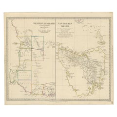
Antique Map of Western Australia and Van Diemen
s Land or Tasmania, 1833
Located in Langweer, NL
Antique map of Australia titled 'Western Australia - Van-Diemen Island'. Two maps on one sheet. Left, Western Australia containing the settlements of the Swan river...
Category
Antique 19th Century Maps
Materials
Paper
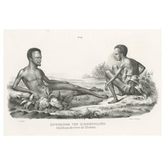
Old Print Depicting Inhabitants of Van Diemen
s Land, Tasmania, Australia, c1845
Located in Langweer, NL
Antique print titled 'Bewohner von Diemensland, Habitans de terre de Diemen'.
This print depicts inhabitants of Van Diemen's Land, Tasmania/Australia. O...
Category
Antique 1840s Prints
Materials
Paper
$322 Sale Price
20% Off
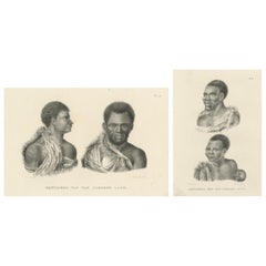
Antique lithographs of Inhabitants of Van Diemen’s Land (Tasmania), 1827
Located in Langweer, NL
Antique lithographs of inhabitants of Van Diemen’s Land, Brodtmann 1827
These original antique lithographs were created in 1827 by Karl Joseph Brodtmann, one of the most important S...
Category
Antique Early 19th Century Swiss Prints
Materials
Paper
Large Antique Map of Bass Strait, Tasmania, Australia by Cook, 1803
Located in Langweer, NL
Antique map Australia titled 'Kaart van Basses Straat tusschen Nieuw Zuid Wales en van Diemensland (..)'. Large chart of Bass Strait and one of t...
Category
Antique 19th Century Dutch Maps
Materials
Paper
$3,479 Sale Price
34% Off
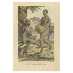
Van Diemen Landers – Antique Handcolored Engraving of Aboriginal Tasmanians 1803
Located in Langweer, NL
Van Diemen Landers – Antique Hand-Colored Engraving of Aboriginal Tasmanians (c.1800)
Description:
An early 19th-century hand-colored ethnographic engraving featuring a family group...
Category
Antique Early 19th Century Dutch Prints
Materials
Paper
Still Thinking About These?
All Recently ViewedMore Ways To Browse
Hms Ship
Birds Eye View Map
North Africa Map
West Africa Map
Antique Compass Map
Antique Maps California
Biblical Maps
Hungary Map
Maps Of Mediterranean
Treasure Map
Antique Navigational Tools
Mississippi Furniture
Caribbean Antiques
Antique Maps West Indies
Antique Mozambique
Malaysian Antique Furniture
Relief Map
Sur Tout