Items Similar to Antique Map of Africa by Delamarche, 1806


Want more images or videos?
Request additional images or videos from the seller
1 of 10
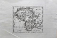
Antique Map of Africa by Delamarche, 1806
$256.34
$320.4320% Off
£191.22
£239.0220% Off
€216
€27020% Off
CA$356.79
CA$445.9920% Off
A$382.77
A$478.4720% Off
CHF 205.31
CHF 256.6420% Off
MX$4,608.56
MX$5,760.7020% Off
NOK 2,588.21
NOK 3,235.2620% Off
SEK 2,360.09
SEK 2,950.1120% Off
DKK 1,646.08
DKK 2,057.6120% Off
About the Item
Antique map titled 'L'Afrique'.
Decorative map of Africa by Robert de Vaugondy, revised and published by Delamarche. Source unknown, to be determined.
Artists and Engravers: Charles Francois Delamarche (1740-1817) founded the important and prolific Paris based Maison Delamarche map publishing firm in the late 18th century. A lawyer by trade Delamarche entered the map business with the acquisition from Jean-Baptiste Fortin of Robert de Vaugondy's map plates and copyrights and later addes many plates from other sources as well. Charles Delamarche eventually passed control of the firm to his son Felix Delamarche (18th C. - 1st half 19th C.) and geographer Charles Dien (1809-1870). It was later passed on to Alexandre Delamarche, who revised and reissued several Delamarche publications in the mid-19th century. The firm continued to publish maps and globes until the middle part of the 19th century.
Condition: Good, given age. Two brown spots just outside the image. Soft diagonal crease right side. Original middle fold as issued. Two stains left and right of the middle fold in the lower margin. General age-related toning and/or occasional minor defects from handling. Please study image carefully.
Date: 1806
Overall size: 38.2 x 28.7 cm.
Image size: 28 x 24 cm.
We sell original antique maps to collectors, historians, educators and interior decorators all over the world. Our collection includes a wide range of authentic antique maps from the 16th to the 20th centuries. Buying and collecting antique maps is a tradition that goes back hundreds of years. Antique maps have proved a richly rewarding investment over the past decade, thanks to a growing appreciation of their unique historical appeal. Today the decorative qualities of antique maps are widely recognized by interior designers who appreciate their beauty and design flexibility. Depending on the individual map, presentation, and context, a rare or antique map can be modern, traditional, abstract, figurative, serious or whimsical. We offer a wide range of authentic antique maps for any budget.
- Dimensions:Height: 11.3 in (28.7 cm)Width: 15.04 in (38.2 cm)Depth: 0 in (0.01 mm)
- Materials and Techniques:Paper,Engraved
- Period:
- Date of Manufacture:1806
- Condition:Good, given age. Two brown spots just outside the image. Soft diagonal crease right side. Original middle fold as issued. Two stains left and right of the middle fold in the lower margin. General age-related toning.
- Seller Location:Langweer, NL
- Reference Number:Seller: PCT-616711stDibs: LU3054325991972
About the Seller
5.0
Recognized Seller
These prestigious sellers are industry leaders and represent the highest echelon for item quality and design.
Platinum Seller
Premium sellers with a 4.7+ rating and 24-hour response times
Established in 2009
1stDibs seller since 2017
2,830 sales on 1stDibs
Typical response time: 1 hour
- ShippingRetrieving quote...Shipping from: Langweer, Netherlands
- Return Policy
More From This Seller
View AllAntique Map of Africa by Dufour, circa 1834
Located in Langweer, NL
Antique map titled 'Afrique'. Uncommon map of Africa. Published by or after A.H. Dufour, circa 1834. Source unknown, to be determined.
Category
Antique Mid-19th Century Maps
Materials
Paper

Antique Map of Africa by Homann Heirs,
1804
Located in Langweer, NL
Antique map titled 'Charte von Africa'. Large, original antique map of Africa by Franz Ludwig Güssefeld. Published by Homann Heirs, 1804.
Category
Antique Early 19th Century Maps
Materials
Paper

$1,424 Sale Price
20% Off
Antique Map of Africa by Bordiga Fratelli
circa 1818
Located in Langweer, NL
Antique map titled 'Carta dell Africa'. Large and quite scarce Italian map of Africa, reflecting the then-current knowledge of the continent's geography, with large areas left comple...
Category
Antique Early 19th Century Maps
Materials
Paper

$1,708 Sale Price
20% Off
Antique Map of Africa by Pierre M. Lapie, Mid-19th Century Print
Located in Langweer, NL
Antique map titled 'Carte d'Afrique'. Map of Africa. This map originates from 'Atlas universel de géographie ancienne et moderne (..)' by Pierre M. Lapie...
Category
Antique Mid-19th Century French Maps
Materials
Paper

$498 Sale Price
30% Off
Antique Map of Africa by Keizer
de Lat, 1788
Located in Langweer, NL
Antique map titled 'Kaartje van Africa (..)'. Uncommon original antique map of Africa. This map originates from 'Nieuwe Natuur- Geschied- en Handelkundige Zak- en Reisatlas' by Gerri...
Category
Antique Late 18th Century Maps
Materials
Paper

$379 Sale Price
20% Off
Original Hand-Colored Antique Map of Africa by Elwe
1792
Located in Langweer, NL
Antique map titled 'l'Afrique Divisée en ses Empires, Royaumes, et Etats'. Decorative large map of Africa. The cartography is typical for the 17th century with the Nile originating i...
Category
Antique Late 18th Century Maps
Materials
Paper

$949 Sale Price
20% Off
You May Also Like
Original Antique Map of Africa by Dower, circa 1835
Located in St Annes, Lancashire
Nice map of Africa
Drawn and engraved by J.Dower
Published by Orr & Smith. C.1835
Unframed.
Free shipping
Category
Antique 1830s English Maps
Materials
Paper

"Africa Vetus": a 17th Century Hand-Colored Map by Sanson
By Nicolas Sanson
Located in Alamo, CA
This original hand-colored copperplate engraved map of Africa entitled "Africa Vetus, Nicolai Sanson Christianiss Galliar Regis Geographi" was originally created by Nicholas Sanson d...
Category
Antique Late 17th Century French Maps
Materials
Paper

Africa: A Large 17th Century Hand-Colored Map by Sanson and Jaillot
By Nicolas Sanson
Located in Alamo, CA
This large original hand-colored copperplate engraved map of Africa entitled "L'Afrique divisee suivant l'estendue de ses principales parties ou sont distingues les uns des autres, L...
Category
Antique 1690s French Maps
Materials
Paper

Large Original Antique Map of Africa. C.1900
Located in St Annes, Lancashire
Fabulous map of Africa
Original color.
Engraved and printed by the George F. Cram Company, Indianapolis.
Published, C.1900.
Unframed.
Free shipping.
Category
Antique 1890s American Maps
Materials
Paper

Map of Africa - Original Etching by C. Brue - 1820
Located in Roma, IT
Map of Africa is an original etching realized by C.Brue in 1820.
The print comes from the Series "Atlas Universal" PL. 31.
The state of preservation of the artwork is good except f...
Category
1820s Modern Figurative Prints
Materials
Etching

Ancient Map of Africa - Etching - 19th century
Located in Roma, IT
This Map of Africa is an etching realized in the 19th century.
The state of preservation of the artwork is good. At the top of the paper, the inscription “Longitudine del Meridiano ...
Category
19th Century More Prints
Materials
Etching
More Ways To Browse
L Afrique Antique
Birds Eye View Map
North Africa Map
West Africa Map
Antique Compass Map
Antique Maps California
Biblical Maps
Hungary Map
Maps Of Mediterranean
Treasure Map
Antique Navigational Tools
Mississippi Furniture
Caribbean Antiques
Antique Maps West Indies
Antique Mozambique
Malaysian Antique Furniture
Relief Map
Sur Tout