Items Similar to Antique Map of Africa by Levasseur
c.1840


Want more images or videos?
Request additional images or videos from the seller
1 of 7
Antique Map of Africa by Levasseur
c.1840
$593.28
£442.91
€500
CA$824.24
A$886.59
CHF 473.82
MX$10,450.38
NOK 5,973.76
SEK 5,461.15
DKK 3,810.56
About the Item
Antique map titled 'Afrique'. Original antique map of Africa. Decorative map of the continent surrounded by allegorical vignettes. Engraved by Raimond Bonheur, father of the famous French artist Rosa Bonheur. This map originates from 'Atlas National (..)' by V. Levasseur. Published circa 1840.
- Dimensions:Height: 22.84 in (58 cm)Width: 30.52 in (77.5 cm)Depth: 1.19 in (3 cm)
- Materials and Techniques:
- Period:
- Date of Manufacture:circa 1840
- Condition:Beautiful map with hand coloring. Frame included, good condition. Please study images carefully.
- Seller Location:Langweer, NL
- Reference Number:Seller: BG-13009-101stDibs: LU3054324193212
About the Seller
5.0
Recognized Seller
These prestigious sellers are industry leaders and represent the highest echelon for item quality and design.
Platinum Seller
Premium sellers with a 4.7+ rating and 24-hour response times
Established in 2009
1stDibs seller since 2017
2,836 sales on 1stDibs
Typical response time: 1 hour
- ShippingRetrieving quote...Shipping from: Langweer, Netherlands
- Return Policy
More From This Seller
View AllAntique Map of Africa by Pierre M. Lapie, Mid-19th Century Print
Located in Langweer, NL
Antique map titled 'Carte d'Afrique'. Map of Africa. This map originates from 'Atlas universel de géographie ancienne et moderne (..)' by Pierre M. Lapie...
Category
Antique Mid-19th Century French Maps
Materials
Paper

$498 Sale Price
30% Off
Antique Map of Africa by Dufour, circa 1834
Located in Langweer, NL
Antique map titled 'Afrique'. Uncommon map of Africa. Published by or after A.H. Dufour, circa 1834. Source unknown, to be determined.
Category
Antique Mid-19th Century Maps
Materials
Paper

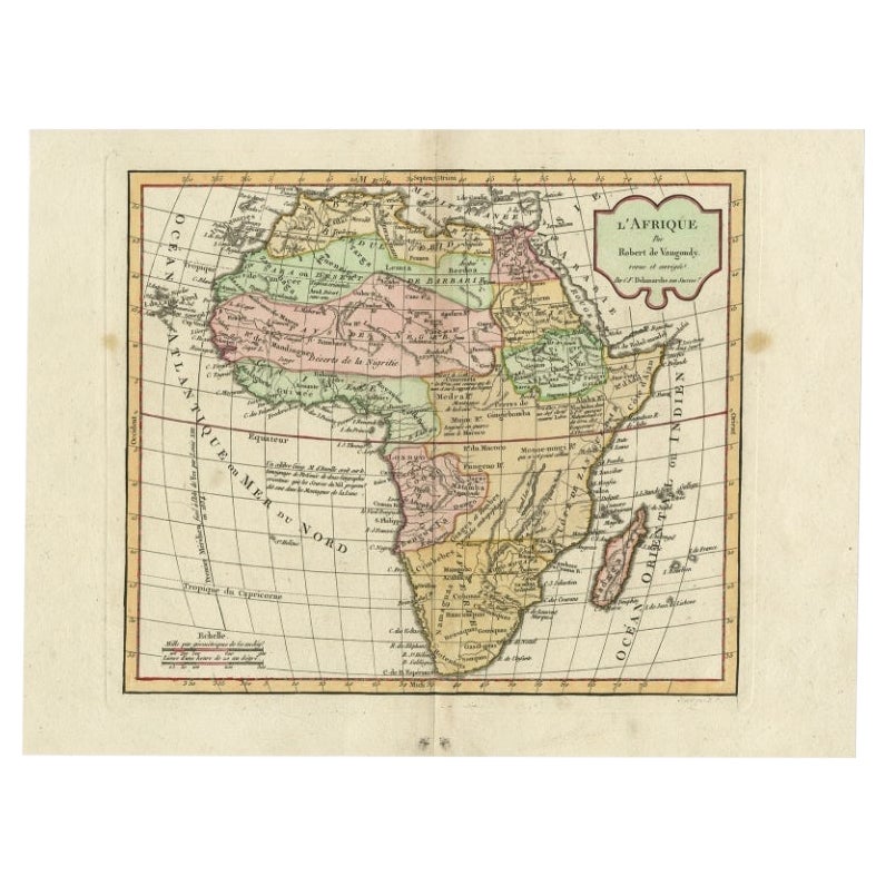
Antique Map of Africa by Delamarche, 1806
Located in Langweer, NL
Antique map titled 'L'Afrique'.
Decorative map of Africa by Robert de Vaugondy, revised and published by Delamarche. Source unknown, to be determined.
Artists and Engravers: Charl...
Category
Antique 19th Century Maps
Materials
Paper

$256 Sale Price
20% Off
Antique Map of Africa by Homann Heirs,
1804
Located in Langweer, NL
Antique map titled 'Charte von Africa'. Large, original antique map of Africa by Franz Ludwig Güssefeld. Published by Homann Heirs, 1804.
Category
Antique Early 19th Century Maps
Materials
Paper

$1,423 Sale Price
20% Off
Antique Map of Africa with European Language Borders, 1852
Located in Langweer, NL
Antique map titled 'Afrika'. Map of Africa. This map originates from 'School-Atlas van alle deelen der Aarde' by Otto Petri.
Artists and Engravers: Published by A. Baedeker (Otto...
Category
Antique 19th Century Maps
Materials
Paper

Antique Map of Africa by A
C, Black, 1870
Located in Langweer, NL
Antique map titled 'Africa'. Original antique map of Africa. This map originates from ‘Black's General Atlas of The World’. Published by A & C. Black, 1870.
Category
Antique Late 19th Century Maps
Materials
Paper

$261 Sale Price
20% Off
You May Also Like
Original Antique Map of Africa by Dower, circa 1835
Located in St Annes, Lancashire
Nice map of Africa
Drawn and engraved by J.Dower
Published by Orr & Smith. C.1835
Unframed.
Free shipping
Category
Antique 1830s English Maps
Materials
Paper

Large Original Antique Map of Africa. C.1900
Located in St Annes, Lancashire
Fabulous map of Africa
Original color.
Engraved and printed by the George F. Cram Company, Indianapolis.
Published, C.1900.
Unframed.
Free shipping.
Category
Antique 1890s American Maps
Materials
Paper

Antique Lithography Map, West Africa, English, Framed, Cartography, Victorian
Located in Hele, Devon, GB
This is an antique lithography map of Western Africa. An English, framed atlas engraving of cartographic interest by John Rapkin, dating to the early Victorian period and later, circ...
Category
Antique Mid-19th Century British Early Victorian Maps
Materials
Wood

"Africa Vetus": a 17th Century Hand-Colored Map by Sanson
By Nicolas Sanson
Located in Alamo, CA
This original hand-colored copperplate engraved map of Africa entitled "Africa Vetus, Nicolai Sanson Christianiss Galliar Regis Geographi" was originally created by Nicholas Sanson d...
Category
Antique Late 17th Century French Maps
Materials
Paper

Africa: A Large 17th Century Hand-Colored Map by Sanson and Jaillot
By Nicolas Sanson
Located in Alamo, CA
This large original hand-colored copperplate engraved map of Africa entitled "L'Afrique divisee suivant l'estendue de ses principales parties ou sont distingues les uns des autres, L...
Category
Antique 1690s French Maps
Materials
Paper

Map of Africa - Original Etching by C. Brue - 1820
Located in Roma, IT
Map of Africa is an original etching realized by C.Brue in 1820.
The print comes from the Series "Atlas Universal" PL. 31.
The state of preservation of the artwork is good except f...
Category
1820s Modern Figurative Prints
Materials
Etching
