Items Similar to Antique Map of Alexander the Great
s Empire
Campaigns, de Vaugondy, 1753


Want more images or videos?
Request additional images or videos from the seller
1 of 11
Antique Map of Alexander the Great
s Empire
Campaigns, de Vaugondy, 1753
$944.89
£701.63
€790
CA$1,298.13
A$1,411.33
CHF 748.29
MX$16,918.30
NOK 9,510.39
SEK 8,712.81
DKK 6,022.33
About the Item
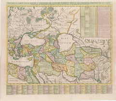
Antique Map of Alexander the Great's Empire
Campaigns, de Vaugondy, 1753
This rare and elegantly engraved map, titled "Antiquor Imperiorum Tabula, in qua Prae Caeteris, Macedonicum seu Alexandri Magni Imperium et Expeditiones Exarantur", was published in 1753 by Didier Robert de Vaugondy, one of the leading cartographers of 18th-century France. It represents the ancient empires of the Eastern Mediterranean and Middle East with a focus on the conquests of Alexander the Great (356–323 B.C.).
Centered on the Arabian Peninsula, the map spans from the Aegean and eastern Mediterranean in the west to the Indus River in the east, and from the Caspian Sea in the north to the full Red Sea and Upper Nile in the south. This expanse includes ancient territories such as Egypt, Mesopotamia, Persia, Bactria, Scythia, and parts of northern India. The route of Alexander’s expeditions is meticulously traced across the map, marking key military campaigns and strategic conquests that established his legendary empire.
Topographical details such as mountain ranges, rivers, and deserts are finely rendered, while towns and ancient place names are labeled throughout. Of note is the nearly blank interior of Arabia—a nod to the limited geographic knowledge of the time regarding that region. A large inset at lower right focuses on Scythia and northern India, elaborating on Alexander’s eastern campaigns with annotations.
The lower left is adorned with a beautiful title cartouche engraved by Elisabeth Haussard, one of the few known female engravers of the 18th century. It features classical decoration including arms, shields, and draped fabric, reflecting the military achievements of Alexander’s empire.
Originally published in 1757 in the first edition of the *Atlas Universel*, this is the first state of the map as dated 1753 in the plate.
Condition Report:
A crisp, dark impression on sturdy, watermarked paper. Light creasing adjacent to the centerfold, otherwise in excellent condition with original outline hand coloring. No significant foxing, tears, or repairs noted.
Framing Tips:
This classical map would suit a dark wood frame—walnut or black—with a wide ivory or parchment-toned archival mat to highlight the aged paper. A subtle gold fillet would complement the ornate cartouche and historical content beautifully.
Technique: Engraving with original hand color
Maker: Didier Robert de Vaugondy, Paris, dated 1753 (published 1757)
- Dimensions:Height: 18.82 in (47.8 cm)Width: 24.41 in (62 cm)Depth: 0.01 in (0.2 mm)
- Materials and Techniques:Paper,Engraved
- Place of Origin:
- Period:
- Date of Manufacture:1753
- Condition:A crisp, dark impression on sturdy, watermarked paper. Light creasing adjacent to the centerfold, otherwise in excellent condition with original outline hand coloring. No significant foxing, tears, or repairs noted.7.
- Seller Location:Langweer, NL
- Reference Number:Seller: BG-141131stDibs: LU3054346013032
About the Seller
5.0
Recognized Seller
These prestigious sellers are industry leaders and represent the highest echelon for item quality and design.
Platinum Seller
Premium sellers with a 4.7+ rating and 24-hour response times
Established in 2009
1stDibs seller since 2017
2,823 sales on 1stDibs
Typical response time: 1 hour
- ShippingRetrieving quote...Shipping from: Langweer, Netherlands
- Return Policy
More From This Seller
View All18th-Century Map of the Eastern Roman Empire by Henri Chatelain, c. 1719
Located in Langweer, NL
Title: 18th-Century Map of the Eastern Roman Empire by Henri Chatelain, c. 1719
Description: This intricately detailed map, titled *Nouvelle Carte pour Servir à l'Histoire de l'Empi...
Category
Antique 1710s Maps
Materials
Paper
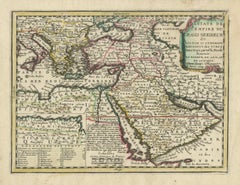
Ottoman Empire Map 1719 – Europe Asia Africa, Jean Chiquet, Paris
Located in Langweer, NL
Title: Ottoman Empire Map 1719 – Europe Asia Africa, Jean Chiquet, Paris
Description:
Original early-18th-century engraved map titled Estats de l’Empire du Grand Seigneur, depicting...
Category
Antique Early 18th Century French Maps
Materials
Paper
Detailed Original Antique Map of the Turkish Empire with Arabia, 1778
Located in Langweer, NL
Title: Etats Due Grand-Seigneur En Asie, Empire De Perse, Pays Des Usbecs, Arabie et Egypte . . . 1753
Detailed map of the Turkish Empire, extending to the Black Sea, Georgia, the...
Category
Antique 1770s French Maps
Materials
Paper

Antique Map of Western Asia by Van Dùren
1752
Located in Langweer, NL
Antique map titled 'Neue Geographische Vorstellung von Asien'. Original antique map of Western Asia. This map originates from 'Neue Sammlung der merkwürdigsten Reisegeschichten, inso...
Category
Antique Mid-18th Century Maps
Materials
Paper

$430 Sale Price
20% Off
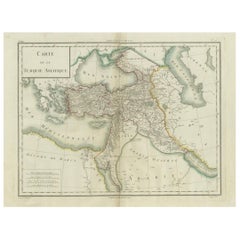
Antique Map of Asian Turkey, Levant, and Mesopotamia by Tardieu, circa 1802
Located in Langweer, NL
This is an original antique map titled "Carte de la Turquie Asiatique," depicting the Asian territories of the Ottoman Empire. Created by Pierre Antoine Tardieu, this map illustrates...
Category
Antique Early 1800s French Maps
Materials
Paper
$421 Sale Price
20% Off
Finely Engraved Historical Map of Middle East and Asia, c.1745
Located in Langweer, NL
Description: Antique map titled'Theatrum Historicum pars Orientalis.'
Finely engraved historical map with a profusion of details. It shows the Middle East and Asia. Decorative ti...
Category
Antique 1740s Maps
Materials
Paper

You May Also Like
Original Antique Map of Ancient Greece, Achaia, Corinth, 1786
Located in St Annes, Lancashire
Great map of Ancient Greece. Showing the region of Thessaly, including Mount Olympus
Drawn by J.D. Barbie Du Bocage
Copper plate engraving by P.F Tardieu
Original hand color...
Category
Antique 1780s French Other Maps
Materials
Paper

Antique French Map of Asia Including China Indoneseia India, 1783
Located in Amsterdam, Noord Holland
Very nice map of Asia. 1783 Dedie au Roy.
Additional information:
Country of Manufacturing: Europe
Period: 18th century Qing (1661 - 1912)
Condition: Overall Condition B (Good Used)...
Category
Antique 18th Century European Maps
Materials
Paper

$486 Sale Price
40% Off
1790 Thomas Stackhouse Map, Entitled "Russia in Europe, " , Ric.a004
Located in Norton, MA
1790 Thomas Stackhouse map, entitled
"Russia in Europe"
Ric.a004
Stackhouse, Thomas
Russia in Europe [map]
London: T. Stackhouse, 1783. Map. Matted hand-colored copper engraving. Image size: 14.5 x 15.25 inches. Mat size: 22.75 x 23.75 inches. A beautiful example of this map of Eastern Europe...
Category
Antique 17th Century Unknown Maps
Materials
Paper

1718 Ides
Witsen Map "Route D
amsterdam a Moscow Et De La Ispahan Et Gamron
Located in Norton, MA
1718 Ides & Witsen map, entitled
"Route D'Amsterdam A Moscow Et De La Ispahan Et Gamron,"
Ric.b005
Subject: Eastern Europe and Central Asia
Period: 1718 (published)
Publicati...
Category
Antique Early 18th Century Dutch Maps
Materials
Paper

Southern
Eastern Europe: A Large 17th C. Hand-colored Map by Sanson
Jaillot
By Nicolas Sanson
Located in Alamo, CA
This large hand-colored map entitled "Estats de L'Empire des Turqs en Europe, ou sont les Beglerbeglicz our Gouvernements" was originally created by Nicholas Sanson d'Abbeville and t...
Category
Antique 1690s French Maps
Materials
Paper

$1,740 Sale Price
20% Off
Persia, Armenia
Adjacent Regions: A 17th Century Hand-colored Map by De Wit
By Frederick de Wit
Located in Alamo, CA
A large 17th century hand colored copperplate engraved map entitled "Novissima nec non Perfectissima Scandinaviae Tabula comprehendens Regnorum Sueciae, Daniae et Norvegiae distincte...
Category
Antique Late 17th Century Dutch Maps
Materials
Paper

$1,500 Sale Price
20% Off
More Ways To Browse
Alexander The Great
Beni Ourain Rugs
Glass Top Wood Base Coffee Tables
T Chair
Pair Of Danish Chairs
Veneer Dining Tables
1970 Italian Armchair
Furniture Uk
House Of Denmark Table And Chairs
Louis Marble Top Side Table
Antique Russian Rugs
Baker Furniture By
For Kids
Sterling Silver Flatware Set Service For 12
Tufted Bar
Pair Of French Antique Armchairs
1970s Brass Glass Coffee Table
Antique Column Base