Items Similar to Antique Map of Ancient Egypt Also Depicting the Nile River and Red Sea, 1845


Want more images or videos?
Request additional images or videos from the seller
1 of 5
Antique Map of Ancient Egypt Also Depicting the Nile River and Red Sea, 1845
$296.64
£221.46
€250
CA$412.12
A$443.30
CHF 236.91
MX$5,225.19
NOK 2,986.88
SEK 2,730.58
DKK 1,905.28
About the Item
Antique map Egypt titled 'General Karte von Alt Aegypten von A.H. Brué'. Large map of Egypt also depicting the Nile river and Red Sea. Source unknown, to be determined.
Artists and Engravers: Made after A.H. Brué.
Condition: Good, general age-related toning. Multiple tears outside image border, please study image carefully.
Date: 1845
Overall size: 45.5 x 58 cm.
Image size: 35.5 x 50 cm.
- Dimensions:Height: 22.84 in (58 cm)Width: 17.92 in (45.5 cm)Depth: 0 in (0.01 mm)
- Materials and Techniques:
- Period:
- Date of Manufacture:1845
- Condition:
- Seller Location:Langweer, NL
- Reference Number:Seller: BG-099811stDibs: LU3054325992562
About the Seller
5.0
Recognized Seller
These prestigious sellers are industry leaders and represent the highest echelon for item quality and design.
Platinum Seller
Premium sellers with a 4.7+ rating and 24-hour response times
Established in 2009
1stDibs seller since 2017
2,836 sales on 1stDibs
Typical response time: 1 hour
- ShippingRetrieving quote...Shipping from: Langweer, Netherlands
- Return Policy
More From This Seller
View AllLarge Antique Map of the Lower Nile Valley Including Egypt and Nubia, 1842
Located in Langweer, NL
Antique map titled 'Carte de l'Égypte, de la Nubie, de l'Abissinie'. Map of Egypt, covering the lower Nile valley including Egypt and Nubia. This map o...
Category
Antique 19th Century French Maps
Materials
Paper

$427 Sale Price
20% Off
Antique Map of Egypt,
1875
Located in Langweer, NL
Antique map titled 'Carte des l'Égypte'. Large map of Egypt. This map originates from 'Atlas de Géographie Moderne Physique et Politique' by A. Levasseur....
Category
Antique Late 19th Century Maps
Materials
Paper

$332 Sale Price
30% Off
Egypt
Arabia Petraea – Large Nile Map, British Cartography, c.1815
Located in Langweer, NL
Egypt & Arabia Petraea – Large Nile Map, British Cartography, c.1815
This impressive early 19th-century map depicts Egypt and Arabia Petraea with exceptional detail, extending from ...
Category
Antique 1810s British Maps
Materials
Paper

Antique Map of Egypt and Arabia Petraea by A
C. Black, 1870
Located in Langweer, NL
Antique map titled 'Egypt and Arabia Petraea'. Original antique map of Egypt and Arabia Petraea. This map originates from ‘Black's General Atlas of The World’. Published by A & C. Bl...
Category
Antique Late 19th Century Maps
Materials
Paper

$144 Sale Price
30% Off
Antique Map of The Nile, Egypt and the Red Sea by Bachiene, 1765
Located in Langweer, NL
Antique map titled 'De XIde Landkaart verbeeldende Egypte en de Woestyne der Schelf-Zee (..).' Map of Biblical Egypt and the Red Sea. With title cartouche, compass rose and scale. Th...
Category
Antique 18th Century Maps
Materials
Paper

Antique Map of Egypt and the Nile River
Located in Langweer, NL
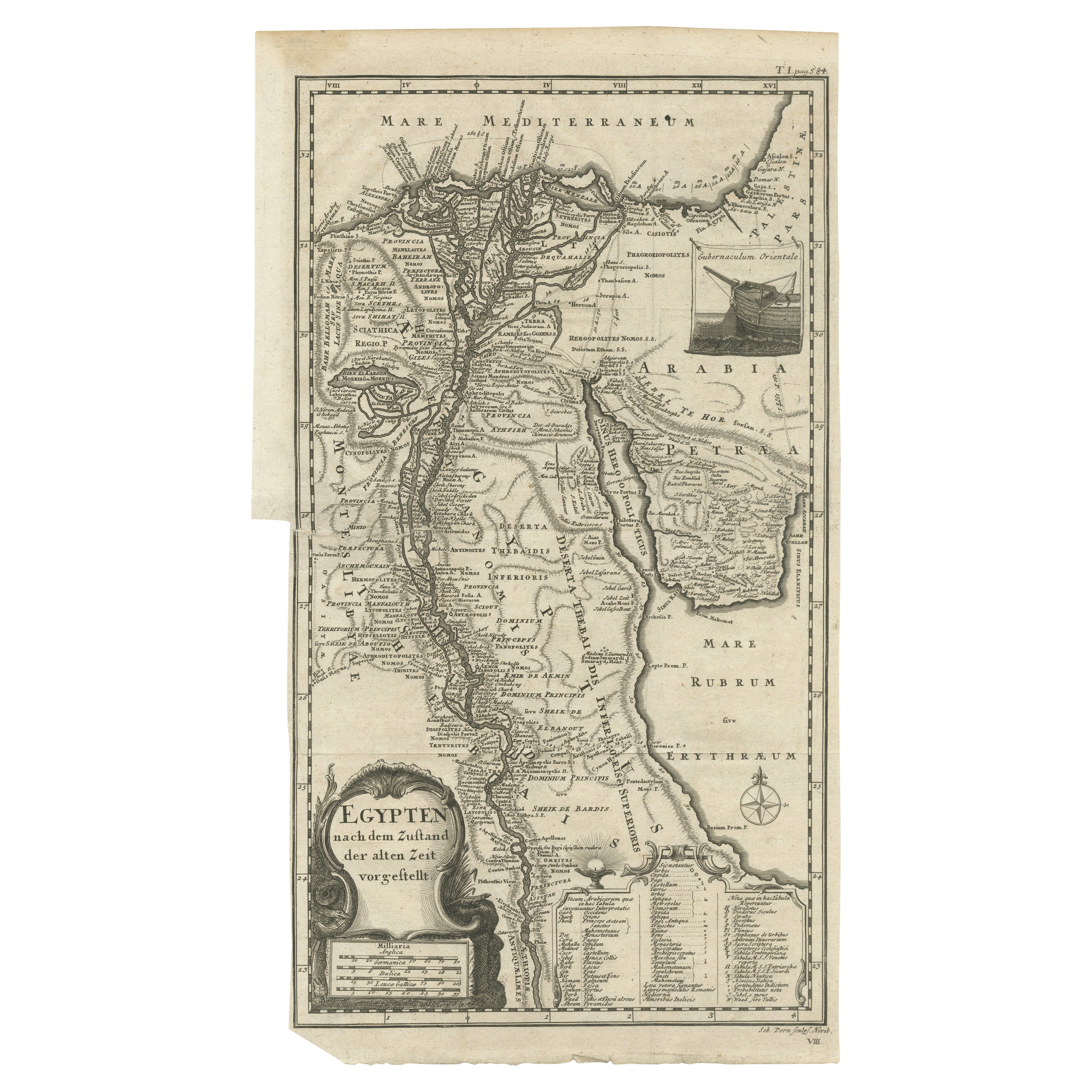
Antique map titled 'Egypten nach dem Zustand der alten Zeit vorgestellt'. This uncommon and richly detailed map of Egypt features hundreds of place names along the Nile. The Sinai Pe...
Category
Antique Mid-18th Century Maps
Materials
Paper
$322 Sale Price
20% Off
You May Also Like
Map of the Holy Land "Carte de la Syrie et de l
Egypte" by Pierre M. Lapie
By Pierre M. Lapie
Located in Alamo, CA
An early 19th century map of ancient Syria and Egypt entitled "Carte de la Syrie et de l'Egypte anciennes/dressée par M. Lapie, Colonel d'Etat Major, et...
Category
Antique Early 19th Century French Maps
Materials
Paper

Map of the Holy Land "Carte de la Syrie et de l
Egypte" by Pierre Lapie
By Pierre M. Lapie
Located in Alamo, CA
This is an early 19th century map of ancient Syria and Egypt entitled "Carte de la Syrie et de l'Egypte anciennes/dressée par M. Lapie, Colonel d'Etat M...
Category
1830s Landscape Prints
Materials
Engraving

Original Antique Map of Ancient Greece- Boeotia, Thebes, 1787
Located in St Annes, Lancashire
Great map of Ancient Greece. Showing the region of Boeotia, including Thebes
Drawn by J.D. Barbie Du Bocage
Copper plate engraving by P.F T...
Category
Antique 1780s French Other Maps
Materials
Paper

Circa 1825 original engraving of the map of Syria by Giraldon Bovinet
Located in PARIS, FR
The circa 1825 original engraving of "Syrie" by Giraldon Bovinet, based on the work of L. Vivien, is a historically significant map that reflects early 19th-century cartographic tech...
Category
1820s Prints and Multiples
Materials
Paper, Engraving

Large Original Antique Map of Morocco. Edward Weller, 1861
Located in St Annes, Lancashire
Great map of Morocco
Lithograph engraving by Edward Weller
Original colour
Published, 1861
Unframed
Good condition.
Category
Antique 1860s English Victorian Maps
Materials
Paper

Large Original Vintage Map of Egypt, circa 1920
Located in St Annes, Lancashire
Great map of Egypt
Unframed
Original color
By John Bartholomew and Co. Edinburgh Geographical Institute
Published, circa 1920
Free shipping.
Category
Vintage 1920s British Maps
Materials
Paper

More Ways To Browse
Birds Eye View Map
North Africa Map
West Africa Map
Antique Compass Map
Antique Maps California
Biblical Maps
Hungary Map
Maps Of Mediterranean
Treasure Map
Antique Navigational Tools
Mississippi Furniture
Caribbean Antiques
Antique Maps West Indies
Antique Mozambique
Malaysian Antique Furniture
Relief Map
Sur Tout
Antique Civil War Maps