Items Similar to Antique Map of Arabia, Red Sea
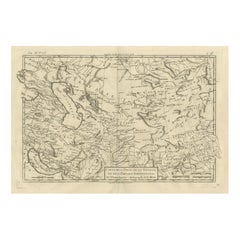
Persian Gulf by Rigobert Bonne, 1780


Want more images or videos?
Request additional images or videos from the seller
1 of 12
Antique Map of Arabia, Red Sea
Persian Gulf by Rigobert Bonne, 1780
$427.16
£318.90
€360
CA$593.45
A$638.35
CHF 341.15
MX$7,524.28
NOK 4,301.11
SEK 3,932.03
DKK 2,743.60
About the Item
Arabia, Red Sea
Persian Gulf – Antique Map, Bonne c1780
Description:
This striking map covers the Arabian Peninsula, the Red Sea, Persian Gulf, Egypt, and parts of East Africa. Rigobert Bonne presents the region with clarity and precision, highlighting coastlines, deserts, caravan routes, and key ports such as Aden and Mocha. The Red Sea is shown in detail, reflecting its strategic importance for trade between Europe and Asia. Mountains and deserts are rendered with elegant hachuring, giving the map both geographic depth and visual rhythm. An important document of 18th-century European views of the Middle East.
Condition:
Good antique condition. Light toning, central fold, small marginal marks.
Framing tips:
Dark wood frame with a wide neutral mat for a scholarly, museum-style presentation.
Keywords:
Arabia map, Red Sea map, Persian Gulf map, Middle East cartography, antique Arabian map, Rigobert Bonne, 18th century geography
Technique: Copper engraving
Maker: Rigobert Bonne, France, circa 1780
- Dimensions:Height: 10.24 in (26 cm)Width: 16.15 in (41 cm)Depth: 0.01 in (0.2 mm)
- Materials and Techniques:Paper,Engraved
- Place of Origin:
- Period:
- Date of Manufacture:Circa 1780
- Condition:Good antique condition. Light toning, central fold, small marginal marks. The map is offered unframed, preserving the sheet in its original, untouched state.
- Seller Location:Langweer, NL
- Reference Number:Seller: BG-14105-141stDibs: LU3054348264192
About the Seller
5.0
Recognized Seller
These prestigious sellers are industry leaders and represent the highest echelon for item quality and design.
Platinum Seller
Premium sellers with a 4.7+ rating and 24-hour response times
Established in 2009
1stDibs seller since 2017
2,836 sales on 1stDibs
Typical response time: 1 hour
- ShippingRetrieving quote...Shipping from: Langweer, Netherlands
- Return Policy
More From This Seller
View AllAntique Map of the Arabian Peninsula by Bonne
c.1780
Located in Langweer, NL
Antique map titled 'Carte de l'Arabie, du Golfe Persique, et de la Mer Rouge (..)'. Original antique map of the Arabian Peninsula, including the horn...
Category
Antique Late 18th Century Maps
Materials
Paper

$522 Sale Price
20% Off
Antique Map of the Arabian Peninsula by Franceschini,
1739
Located in Langweer, NL
Antique map titled 'Conventus et Residentiae'. Rare map of the Arabian Peninsula. This map originates from 'Provinciarum et Conventum Fratrum Discalc...
Category
Antique Mid-18th Century Maps
Materials
Paper

$533 Sale Price
40% Off
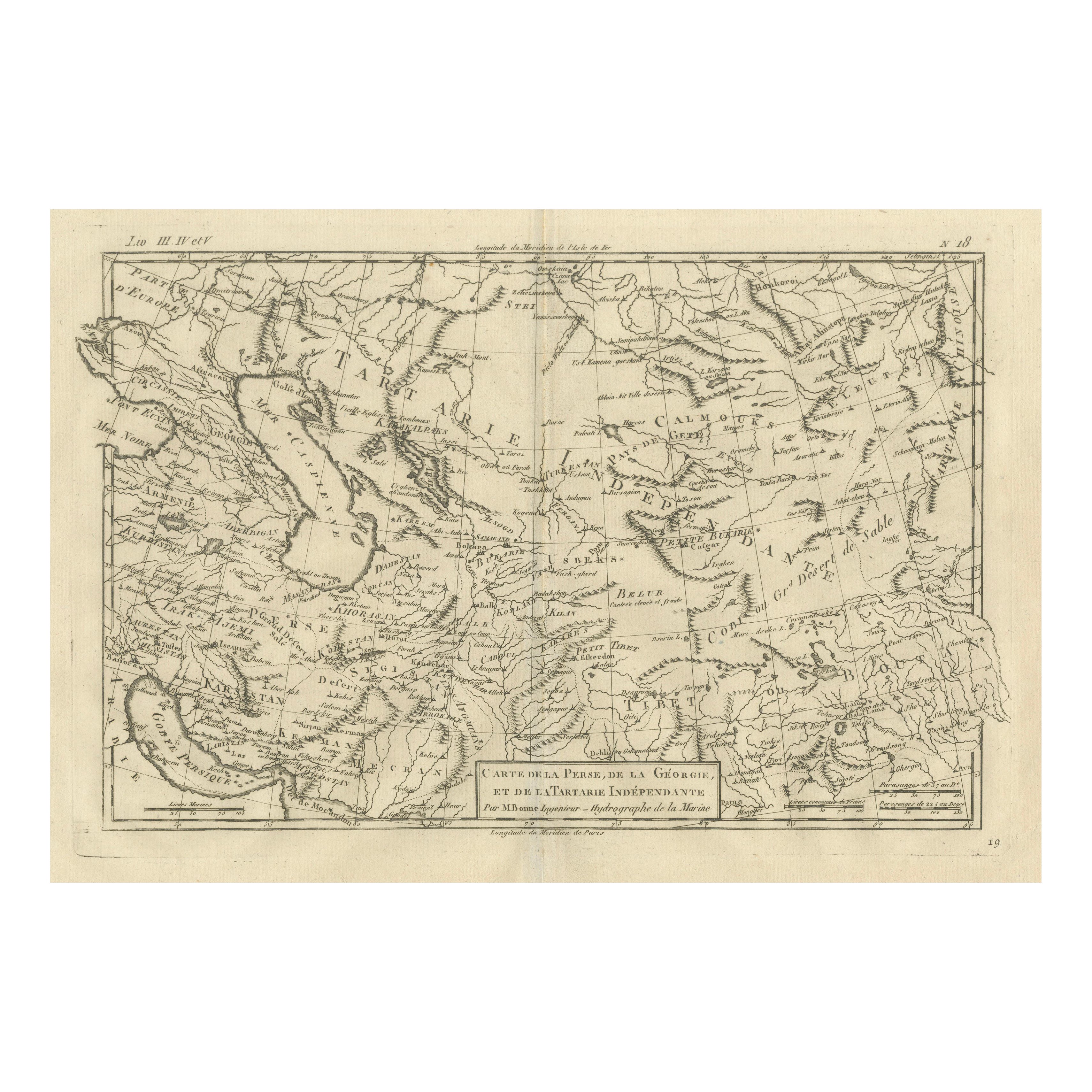
Antique Map of the Persian Gulf and Caspian Sea Region by R. Bonne, 1780
Located in Langweer, NL
Antique print titled 'Carte de la Perse, de la Georgie, et de la Tartarie Independante'. Shows the region from the Persian Gulf and Caspian Sea in the wes...
Category
Antique Late 18th Century French Maps
Materials
Paper

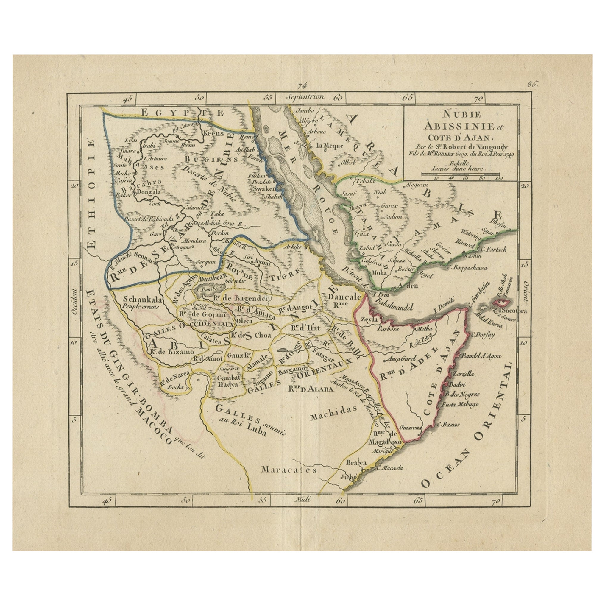
Antique Map of Abyssinia, Sudan and the Red Sea, Arabia and Egypt South, 1749
Located in Langweer, NL
Antique map titled 'Nubie, Abissinie et Cote d'Ajan'. Map of Abyssinia, Sudan and the Red Sea by Robert Vaugondy. Covers from Arabia and Egypt south to Mogadishu and includes parts o...
Category
Antique 18th Century Maps
Materials
Paper
Antique Map of Persia and Georgia by Rigobert Bonne, Circa 1780
Located in Langweer, NL
Persia, Georgia & Central Asia – Antique Map, Bonne c1780
Description:
Covering Persia, Georgia, and parts of Central Asia, this map illustrates mountain chains, deserts, and river ...
Category
Antique Late 18th Century French Maps
Materials
Paper
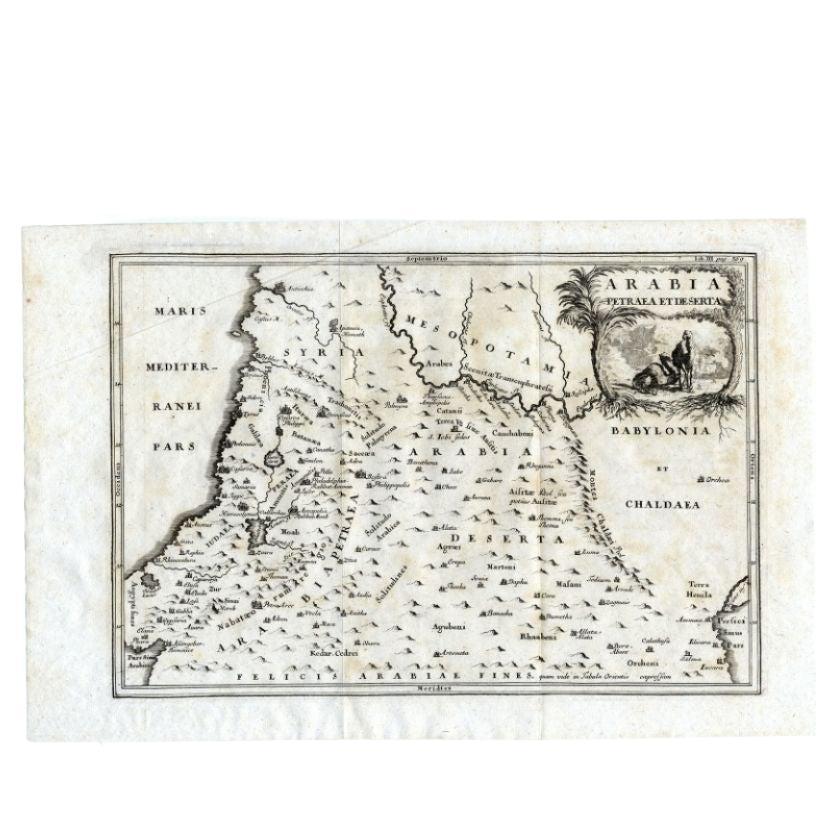
Antique Map of the Arabian Desert by Cellarius, 1731
Located in Langweer, NL
Antique map titled 'Arabia Petraea et Deserta.' Arabian desert with present day Israel, Jordania, Iraq. With decorative cartouche showing dromedaries. T...
Category
Antique 18th Century Maps
Materials
Paper

$166 Sale Price
20% Off
You May Also Like
Map of Nubia and Abissinia - Original Etching by Antonio Zatta - 1784
Located in Roma, IT
This Map of Nubia and Abissinia is an etching realized by Antonio Zatta in Venice in 1784.
The state of preservation of the artwork is good expect for the worn paper with some littl...
Category
1770s Landscape Prints
Materials
Etching

Persia, Armenia
Adjacent Regions: A 17th Century Hand-colored Map by De Wit
By Frederick de Wit
Located in Alamo, CA
A large 17th century hand colored copperplate engraved map entitled "Novissima nec non Perfectissima Scandinaviae Tabula comprehendens Regnorum Sueciae, Daniae et Norvegiae distincte...
Category
Antique Late 17th Century Dutch Maps
Materials
Paper

Map of Persia - Original Etching - Late 19th Century
Located in Roma, IT
This Map of Persia is an etching realized by an anonymous artist.
The state of preservation of the artwork is good with some small diffused stains.
Sheet dimension: 25.5 x 44
At t...
Category
Late 19th Century Modern Figurative Prints
Materials
Etching
Mediterranean and Adriatic Seas: Original 18th Century Hand-colored Map by Bowen
Located in Alamo, CA
This is an original 18th century hand-colored map entitled "An Accurate Chart of The Mediterranean and Adriatic Sea's; with the Archipelago & Part of the Black Sea. Exhibiting all th...
Category
Mid-18th Century Old Masters Landscape Prints
Materials
Engraving

Original Antique Map of Ancient Greece- Boeotia, Thebes, 1787
Located in St Annes, Lancashire
Great map of Ancient Greece. Showing the region of Boeotia, including Thebes
Drawn by J.D. Barbie Du Bocage
Copper plate engraving by P.F T...
Category
Antique 1780s French Other Maps
Materials
Paper

Persiae, Armeniae, Natoliae et Arabiae Descriptio per Frederick deWit 1666 map
Located in Paonia, CO
Map of Persiae, Armeniae, Natoliae et Arabiae Descriptio per F de Wit 1688 engraving from: Atlas Contractus Orbis Terrarum Praecipuas ac Novissimas Complectens Tabulas. Amsterdam, N. Visscher, 1656-77. (Koeman III, Vis5-8) This highly decorative map of the Middle East is by the Dutch engraver, publisher, and map seller...
Category
1660s Realist Landscape Prints
Materials
Engraving
