Items Similar to Antique Map of the Arabian Desert by Cellarius, 1731


Want more images or videos?
Request additional images or videos from the seller
1 of 5
Antique Map of the Arabian Desert by Cellarius, 1731
$168.13
$210.1620% Off
£124.52
£155.6520% Off
€140
€17520% Off
CA$229.99
CA$287.4820% Off
A$250.30
A$312.8720% Off
CHF 132.68
CHF 165.8520% Off
MX$3,011.26
MX$3,764.0820% Off
NOK 1,682.84
NOK 2,103.5520% Off
SEK 1,539.68
SEK 1,924.6020% Off
DKK 1,066.82
DKK 1,333.5320% Off
About the Item
Antique map titled 'Arabia Petraea et Deserta.' Arabian desert with present day Israel, Jordania, Iraq. With decorative cartouche showing dromedaries. This authentic print originates from: 'Notitia orbis antiqui, sive geographia plenior', by Christoph Cellarius, ed. published in Leipzig by Johann Frederick Gleditsch in 1731-32. Ref. Brunet I, 1724. Ebert 3868. An early standard work on the geography of Classical Antiquity first published in 1686. Artists and Engravers: Author: Christoph Cellarius (1638 - 1707) or Christopher Keller was a German scholar, historian and textbook publisher. Cellarius held academic positions in both Weimar and Halle. Cellarius's most important work was his 1683 publication of 'A Universal History Divided into an Ancient, Medieval, and New Period.' It was in this work that the concept of history as divisible into three distinct periods (Ancient History, Mediaeval History, and Modern History) was introduced. It had great impact on the way future historians would interpret the past.
Artist: Author: Christoph Cellarius (1638 - 1707) or Christopher Keller was a German scholar, historian and textbook publisher. Cellarius held academic positions in both Weimar and Halle. Cellarius's most important work was his 1683 publication of 'A Universal History Divided into an Ancient, Medieval, and New Period.' It was in this work that the concept of history as divisible into three distinct periods (Ancient History, Mediaeval History, and Modern History) was introduced. It had great impact on the way future historians would interpret the past.
Condition: Fair/good, general age related toning. Paper edges a bit irregular from binding. Original folds as issued. Ocassional light folding. Please study image carefully.
Date: 1731
Overall size: 36 x 24 cm.
Image size: 0.001 x 30 x 20 cm.
Antique prints have long been appreciated for both their aesthetic and investment value. They were the product of engraved, etched or lithographed plates. These plates were handmade out of wood or metal, which required an incredible level of skill, patience and craftsmanship. Whether you have a house with Victorian furniture or more contemporary decor an old engraving can enhance your living space. We offer a wide range of authentic antique prints for any budget.
- Dimensions:Height: 9.45 in (24 cm)Width: 14.18 in (36 cm)Depth: 0 in (0.01 mm)
- Materials and Techniques:
- Period:
- Date of Manufacture:1731
- Condition:
- Seller Location:Langweer, NL
- Reference Number:Seller: PCT-409441stDibs: LU3054327771802
About the Seller
5.0
Recognized Seller
These prestigious sellers are industry leaders and represent the highest echelon for item quality and design.
Platinum Seller
Premium sellers with a 4.7+ rating and 24-hour response times
Established in 2009
1stDibs seller since 2017
2,816 sales on 1stDibs
Typical response time: 1 hour
- ShippingRetrieving quote...Shipping from: Langweer, Netherlands
- Return Policy
More From This Seller
View AllAntique Map of the Arabian Peninsula by Franceschini,
1739
Located in Langweer, NL
Antique map titled 'Conventus et Residentiae'. Rare map of the Arabian Peninsula. This map originates from 'Provinciarum et Conventum Fratrum Discalc...
Category
Antique Mid-18th Century Maps
Materials
Paper

$540 Sale Price
40% Off
Antique Map of the Arabian Peninsula by Bellin
c.1740
Located in Langweer, NL
Antique map titled 'Carte de la Coste d'Arabie, Mer Rouge et Golfe de Perse'. Original antique map of the Arabian Peninsula, labes both Mecca and Med...
Category
Antique Mid-18th Century Maps
Materials
Paper

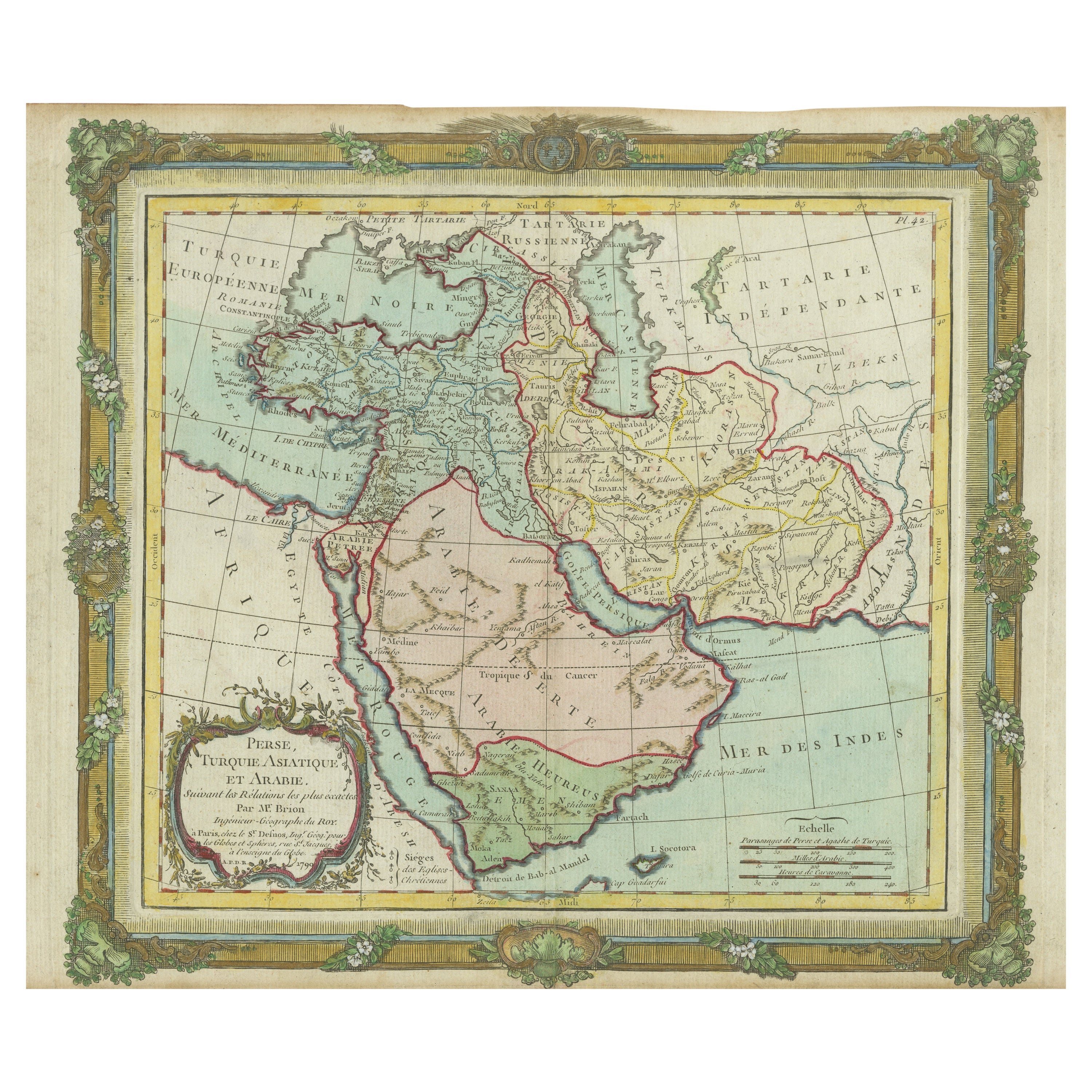
Antique Map of the Middle East with a Large Arabia, 1799
Located in Langweer, NL
Antique map titled 'Perse, Turquie Asiatique et Arabie (..)'. Map of the Middle East with a large Arabia, extending from the Black Sea to the In...
Category
Antique Late 18th Century Maps
Materials
Paper
Antique Map of the Middle East by Mortier, 1700
Located in Langweer, NL
Antique map titled 'Carte de la Situation du Paradis Terrestre (..)'. Detailed map of the Holy Land and the Middle East, centered on the Garden of Eden and including a large Cyprus. ...
Category
Antique 18th Century Maps
Materials
Paper

Antique Map of the Arabian Peninsula by Bonne
c.1780
Located in Langweer, NL
Antique map titled 'Carte de l'Arabie, du Golfe Persique, et de la Mer Rouge (..)'. Original antique map of the Arabian Peninsula, including the horn...
Category
Antique Late 18th Century Maps
Materials
Paper

$528 Sale Price
20% Off
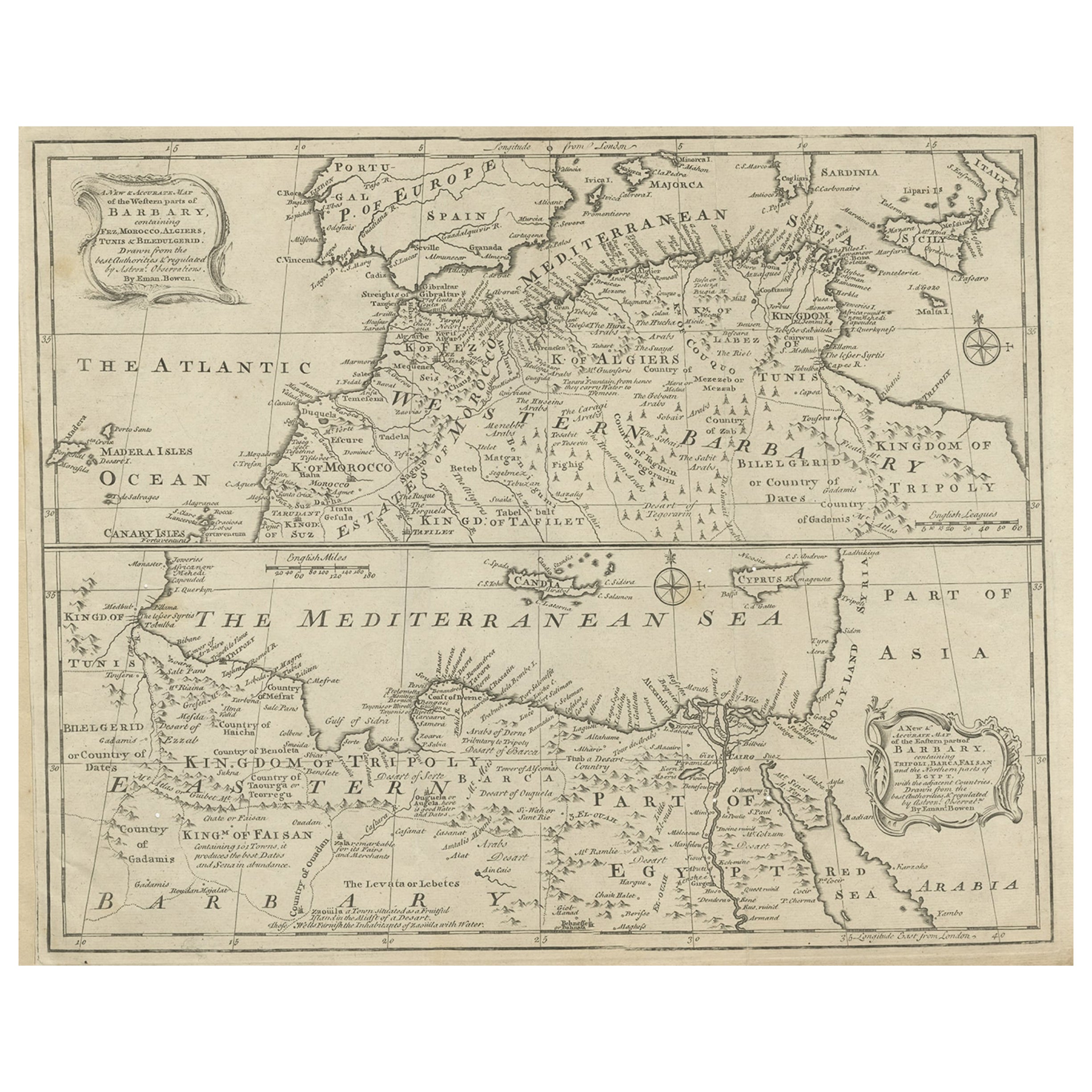
Antique Map of Western and Eastern Barbary in Africa, c.1744
Located in Langweer, NL
Antique map titled 'A New
Accurate Map of the Western Parts of Barbary' and 'A New
Accurate Map of the Eastern Parts of Barbary'. Decorative maps of North Africa and the ...
Category
Antique 18th Century British Maps
Materials
Paper
You May Also Like
Persia, Armenia
Adjacent Regions: A 17th Century Hand-colored Map by De Wit
By Frederick de Wit
Located in Alamo, CA
A large 17th century hand colored copperplate engraved map entitled "Novissima nec non Perfectissima Scandinaviae Tabula comprehendens Regnorum Sueciae, Daniae et Norvegiae distincte...
Category
Antique Late 17th Century Dutch Maps
Materials
Paper

$1,500 Sale Price
20% Off
Africa: A Large 17th Century Hand-Colored Map by Sanson and Jaillot
By Nicolas Sanson
Located in Alamo, CA
This large original hand-colored copperplate engraved map of Africa entitled "L'Afrique divisee suivant l'estendue de ses principales parties ou sont distingues les uns des autres, L...
Category
Antique 1690s French Maps
Materials
Paper

$1,740 Sale Price
20% Off
"Nova Barbariae Descriptio", a 17th Century Hand-Colored Map of North Africa
By Johannes Janssonius
Located in Alamo, CA
This original attractive 17th century hand-colored map of North Africa entitled "Nova Barbariae Descriptio" by Johannes Janssonius was published in Paris in 1635. It includes the Med...
Category
Antique Mid-17th Century Dutch Maps
Materials
Paper

$1,020 Sale Price
20% Off
Original Antique Map of Africa by Dower, circa 1835
Located in St Annes, Lancashire
Nice map of Africa
Drawn and engraved by J.Dower
Published by Orr & Smith. C.1835
Unframed.
Free shipping
Category
Antique 1830s English Maps
Materials
Paper

"Africa Vetus": a 17th Century Hand-Colored Map by Sanson
By Nicolas Sanson
Located in Alamo, CA
This original hand-colored copperplate engraved map of Africa entitled "Africa Vetus, Nicolai Sanson Christianiss Galliar Regis Geographi" was originally created by Nicholas Sanson d...
Category
Antique Late 17th Century French Maps
Materials
Paper

$1,100 Sale Price
20% Off
Original Antique Map of South America. C.1780
Located in St Annes, Lancashire
Great map of South America
Copper-plate engraving
Published C.1780
Two small worm holes to left side of map
Unframed.
Category
Antique Early 1800s English Georgian Maps
Materials
Paper

More Ways To Browse
Arabian Antique
Antique Alabama Map
Antique Framed Map Engravings
Antique Furniture Cheshire
Antique Great Lakes Map
Antique Map Of Michigan
Antique Map Of Turkish Empire
Antique Map Of Yorkshire
Bali Map
Bermuda Map
British Empire Map
Caucasus Map
Framed London Map
J Warren
Large Framed Maps
Map Of Jamaica
Map Of Madagascar
Map Of Normandy