Items Similar to Antique Map of the Arabian Peninsula by Bellin
c.1740


Want more images or videos?
Request additional images or videos from the seller
1 of 5
Antique Map of the Arabian Peninsula by Bellin
c.1740
$595.70
£442.56
€500
CA$825.96
A$888.25
CHF 474.95
MX$10,712.05
NOK 6,006.06
SEK 5,472.29
DKK 3,810.83
About the Item
Antique map titled 'Carte de la Coste d'Arabie, Mer Rouge et Golfe de Perse'. Original antique map of the Arabian Peninsula, labes both Mecca and Medina. Depicts the region from Alexandria, Egypt to the Gulf of Oman and from the Mediterranean Sea and Iraq to the Horn of Africa. Published by J.N. Bellin, circa 1740.
- Dimensions:Height: 10.04 in (25.5 cm)Width: 15.75 in (40 cm)Depth: 0.02 in (0.5 mm)
- Materials and Techniques:
- Period:
- Date of Manufacture:circa 1740
- Condition:General age-related toning. Original folding line, later hand coloring. Shows minor wear and creasing, blank verso. Please study image carefully.
- Seller Location:Langweer, NL
- Reference Number:Seller: BG-129671stDibs: LU3054324168332
About the Seller
5.0
Recognized Seller
These prestigious sellers are industry leaders and represent the highest echelon for item quality and design.
Platinum Seller
Premium sellers with a 4.7+ rating and 24-hour response times
Established in 2009
1stDibs seller since 2017
2,826 sales on 1stDibs
Typical response time: 1 hour
- ShippingRetrieving quote...Shipping from: Langweer, Netherlands
- Return Policy
More From This Seller
View AllAntique Map of the Arabian Peninsula by Franceschini,
1739
Located in Langweer, NL
Antique map titled 'Conventus et Residentiae'. Rare map of the Arabian Peninsula. This map originates from 'Provinciarum et Conventum Fratrum Discalc...
Category
Antique Mid-18th Century Maps
Materials
Paper

$536 Sale Price
40% Off
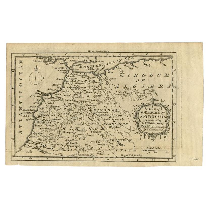
Antique Map of the Empire of Morocco by Kitchin, c.1760
By Thomas Kitchin
Located in Langweer, NL
Antique map titled 'A Map of the Empire of Morocco Comprehending the Kingdoms of Fez, Morocco'. Original antique map of the kingdoms of Fez, Algiers, Segelmese, Tafilet and Morocco. ...
Category
Antique 18th Century British Maps
Materials
Paper
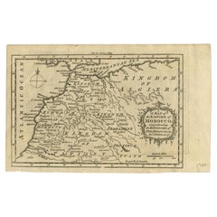
$171 Sale Price
20% Off
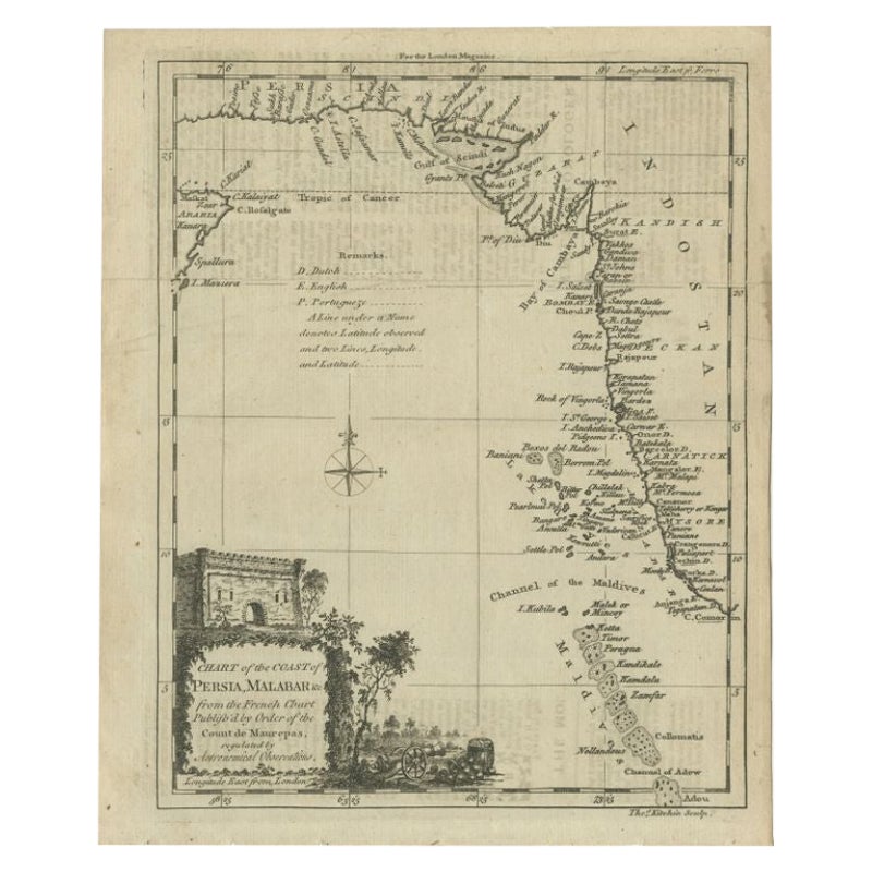
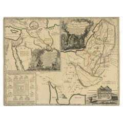
Antique Map of the Coast of Southwest Asia by Kitchin, c.1770
By Thomas Kitchin
Located in Langweer, NL
Antique map titled 'Chart of the Coast of Persia, Malabar & c'. Antique map of the coast of Southwest Asia. It shows the Maldives and part of Persia and India. Published for the 'Lon...
Category
Antique 18th Century Maps
Materials
Paper

$107 Sale Price
20% Off
Antique Map of the Arabian Peninsula by Bonne
c.1780
Located in Langweer, NL
Antique map titled 'Carte de l'Arabie, du Golfe Persique, et de la Mer Rouge (..)'. Original antique map of the Arabian Peninsula, including the horn...
Category
Antique Late 18th Century Maps
Materials
Paper

$524 Sale Price
20% Off
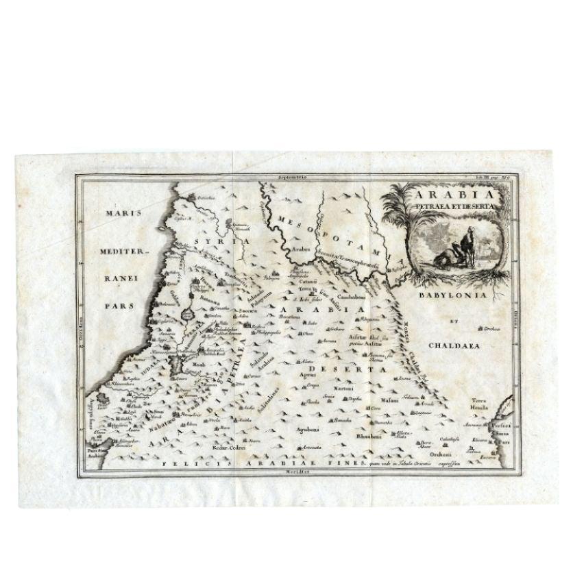
Antique Map of the Arabian Desert by Cellarius, 1731
Located in Langweer, NL
Antique map titled 'Arabia Petraea et Deserta.' Arabian desert with present day Israel, Jordania, Iraq. With decorative cartouche showing dromedaries. T...
Category
Antique 18th Century Maps
Materials
Paper

$166 Sale Price
20% Off
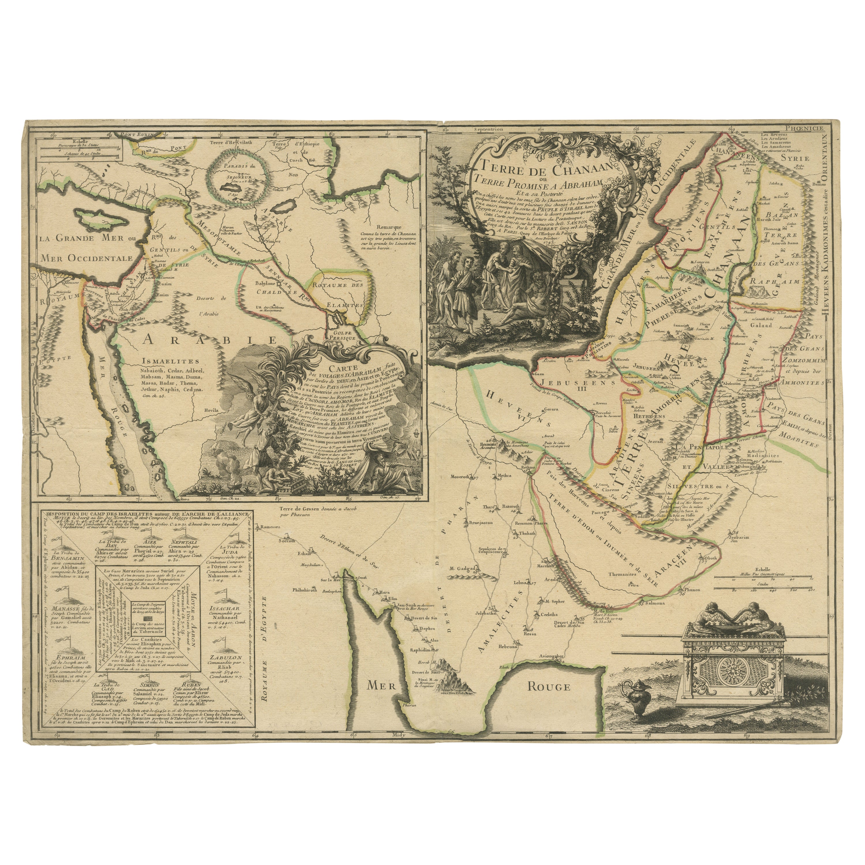
Old Map of Arabian Peninsula and Canaan, Highlighting Biblical Territories, 1750
Located in Langweer, NL
This antique map, titled "Terre de Chanaan ou Terre Promise a Abraham," is a finely detailed copper-engraved map created around 1750 by Delamarche in Paris, based on earlier works by...
Category
Antique 1750s French Maps
Materials
Paper
You May Also Like
West Coast of Africa, Guinea
Sierra Leone: An 18th Century Map by Bellin
By Jacques-Nicolas Bellin
Located in Alamo, CA
Jacques Bellin's copper-plate map entitled "Partie de la Coste de Guinee Dupuis la Riviere de Sierra Leona Jusquau Cap das Palmas", depicting the coast of Guinea and Sierra Leone in ...
Category
Antique Mid-18th Century French Maps
Materials
Paper

Antique French Map of Asia Including China Indoneseia India, 1783
Located in Amsterdam, Noord Holland
Very nice map of Asia. 1783 Dedie au Roy.
Additional information:
Country of Manufacturing: Europe
Period: 18th century Qing (1661 - 1912)
Condition: Overall Condition B (Good Used)...
Category
Antique 18th Century European Maps
Materials
Paper

$486 Sale Price
40% Off
West Africa Entitled "Guinea Propria": An 18th Century Hand Colored Homann Map
By Johann Baptist Homann
Located in Alamo, CA
This is a scarce richly hand colored copper plate engraved map of Africa entitled "Guinea Propria, nec non Nigritiae vel Terrae Nigrorum Maxima Pars" by Johann Baptist Homann (1664-1...
Category
Antique Mid-18th Century German Maps
Materials
Paper

Southern Greece: A Large 17th C. Hand-colored Map by Sanson and Jaillot
By Nicolas Sanson
Located in Alamo, CA
This large original hand-colored copperplate engraved map of southern Greece and the Pelopponese Peninsula entitled "La Moree Et Les Isles De Zante, Cefalonie, Ste. Marie, Cerigo & C...
Category
Antique 1690s French Maps
Materials
Paper

Persia, Armenia
Adjacent Regions: A 17th Century Hand-colored Map by De Wit
By Frederick de Wit
Located in Alamo, CA
A large 17th century hand colored copperplate engraved map entitled "Novissima nec non Perfectissima Scandinaviae Tabula comprehendens Regnorum Sueciae, Daniae et Norvegiae distincte...
Category
Antique Late 17th Century Dutch Maps
Materials
Paper

Map of Nubia and Abissinia - Original Etching by Antonio Zatta - 1784
Located in Roma, IT
This Map of Nubia and Abissinia is an etching realized by Antonio Zatta in Venice in 1784.
The state of preservation of the artwork is good expect for the worn paper with some littl...
Category
1770s Landscape Prints
Materials
Etching
