Items Similar to Antique Map of the Arabian Peninsula by Franceschini,
1739


Want more images or videos?
Request additional images or videos from the seller
1 of 5
Antique Map of the Arabian Peninsula by Franceschini,
1739
$533.95
$889.9240% Off
£398.62
£664.3740% Off
€450
€75040% Off
CA$741.82
CA$1,236.3640% Off
A$797.93
A$1,329.8940% Off
CHF 426.44
CHF 710.7340% Off
MX$9,405.35
MX$15,675.5840% Off
NOK 5,376.39
NOK 8,960.6440% Off
SEK 4,915.04
SEK 8,191.7340% Off
DKK 3,429.51
DKK 5,715.8440% Off
About the Item
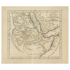
Antique map titled 'Conventus et Residentiae'. Rare map of the Arabian Peninsula. This map originates from 'Provinciarum et Conventum Fratrum Discalceatorum Ordinis Virginis Maria del Monte Carmelo' by D. Franceschini. Published 1739.
- Dimensions:Height: 8.08 in (20.5 cm)Width: 10.44 in (26.5 cm)Depth: 0.02 in (0.5 mm)
- Materials and Techniques:
- Period:
- Date of Manufacture:1739
- Condition:General age-related toning. Shows some wear and foxing. Few spots outside image and a defect in the top right corner. Blank verso. Please study image carefully.
- Seller Location:Langweer, NL
- Reference Number:Seller: BG-129441stDibs: LU3054323450822
About the Seller
5.0
Recognized Seller
These prestigious sellers are industry leaders and represent the highest echelon for item quality and design.
Platinum Seller
Premium sellers with a 4.7+ rating and 24-hour response times
Established in 2009
1stDibs seller since 2017
2,836 sales on 1stDibs
Typical response time: 1 hour
- ShippingRetrieving quote...Shipping from: Langweer, Netherlands
- Return Policy
More From This Seller
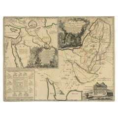
View AllAntique Map of the Arabian Peninsula by Bellin
c.1740
Located in Langweer, NL
Antique map titled 'Carte de la Coste d'Arabie, Mer Rouge et Golfe de Perse'. Original antique map of the Arabian Peninsula, labes both Mecca and Med...
Category
Antique Mid-18th Century Maps
Materials
Paper

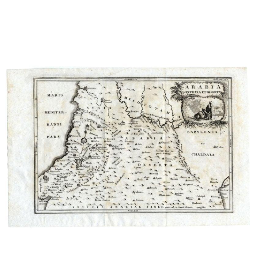
Antique Map of the Arabian Desert by Cellarius, 1731
Located in Langweer, NL
Antique map titled 'Arabia Petraea et Deserta.' Arabian desert with present day Israel, Jordania, Iraq. With decorative cartouche showing dromedaries. T...
Category
Antique 18th Century Maps
Materials
Paper

$166 Sale Price
20% Off
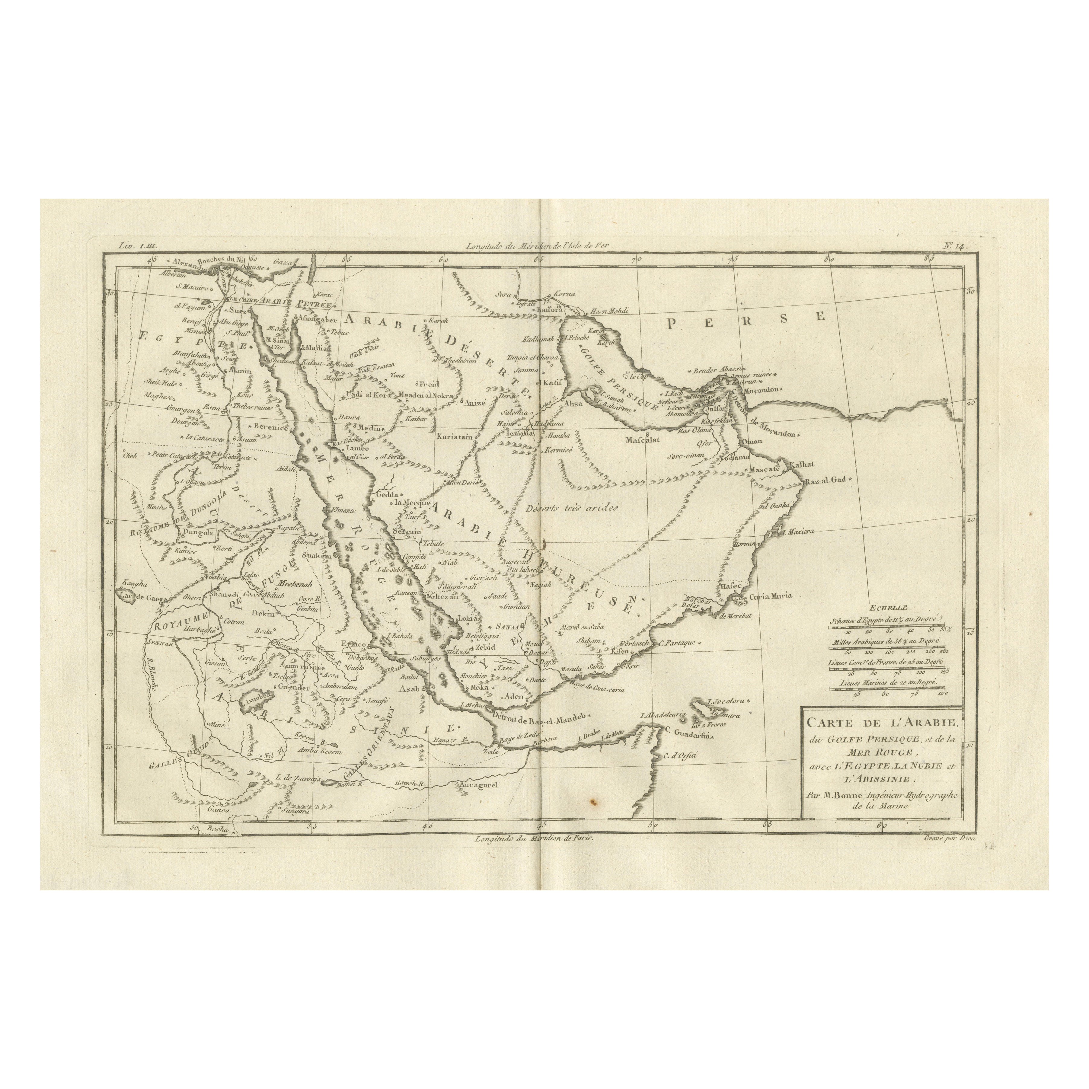
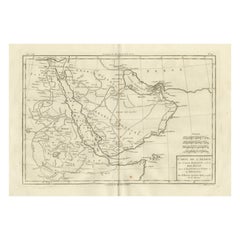
Antique Map of the Arabian Peninsula by Bonne
c.1780
Located in Langweer, NL
Antique map titled 'Carte de l'Arabie, du Golfe Persique, et de la Mer Rouge (..)'. Original antique map of the Arabian Peninsula, including the horn...
Category
Antique Late 18th Century Maps
Materials
Paper

$522 Sale Price
20% Off
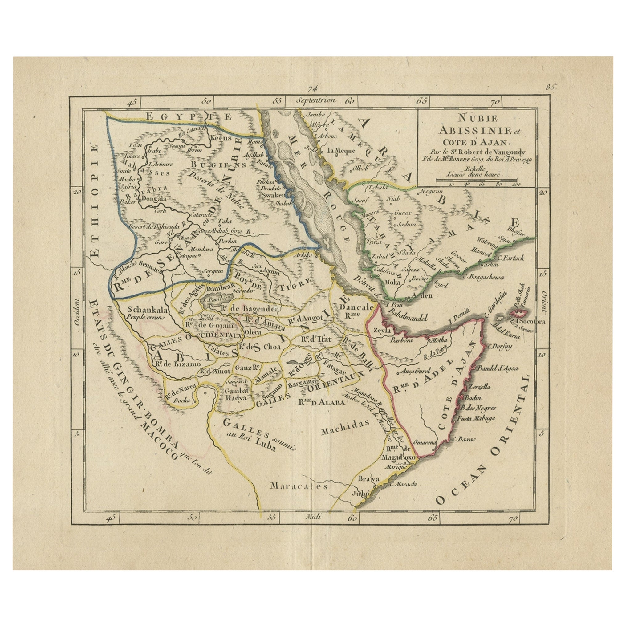
Antique Map of Abyssinia, Sudan and the Red Sea, Arabia and Egypt South, 1749
Located in Langweer, NL
Antique map titled 'Nubie, Abissinie et Cote d'Ajan'. Map of Abyssinia, Sudan and the Red Sea by Robert Vaugondy. Covers from Arabia and Egypt south to Mogadishu and includes parts o...
Category
Antique 18th Century Maps
Materials
Paper
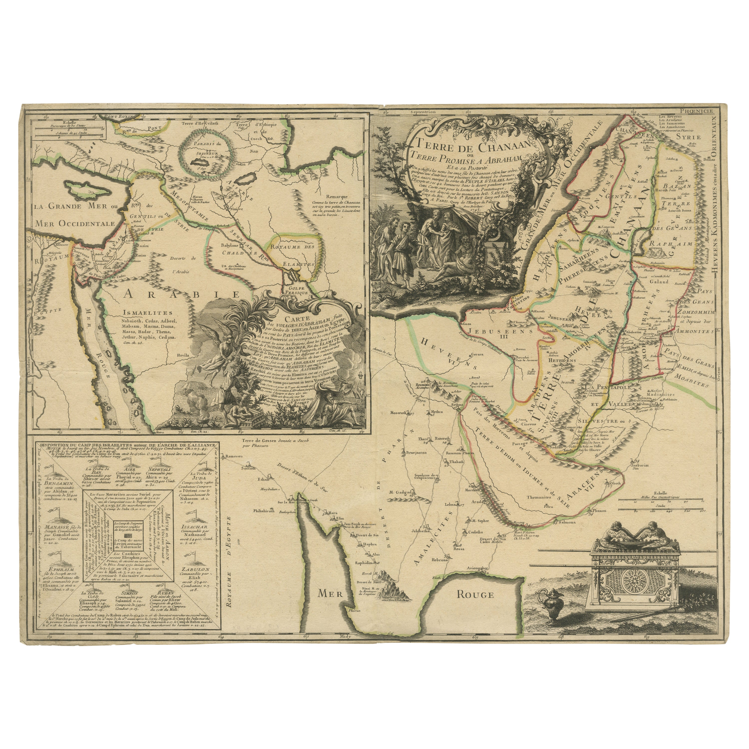
Old Map of Arabian Peninsula and Canaan, Highlighting Biblical Territories, 1750
Located in Langweer, NL
This antique map, titled "Terre de Chanaan ou Terre Promise a Abraham," is a finely detailed copper-engraved map created around 1750 by Delamarche in Paris, based on earlier works by...
Category
Antique 1750s French Maps
Materials
Paper
Antique Map of Arabia, Red Sea
Persian Gulf by Rigobert Bonne, 1780
Located in Langweer, NL
Arabia, Red Sea & Persian Gulf – Antique Map, Bonne c1780
Description:
This striking map covers the Arabian Peninsula, the Red Sea, Persian Gulf, Egypt, and parts of East Africa. Ri...
Category
Antique Late 18th Century French Maps
Materials
Paper
You May Also Like
Map of Nubia and Abissinia - Original Etching by Antonio Zatta - 1784
Located in Roma, IT
This Map of Nubia and Abissinia is an etching realized by Antonio Zatta in Venice in 1784.
The state of preservation of the artwork is good expect for the worn paper with some littl...
Category
1770s Landscape Prints
Materials
Etching

Persia, Armenia
Adjacent Regions: A 17th Century Hand-colored Map by De Wit
By Frederick de Wit
Located in Alamo, CA
A large 17th century hand colored copperplate engraved map entitled "Novissima nec non Perfectissima Scandinaviae Tabula comprehendens Regnorum Sueciae, Daniae et Norvegiae distincte...
Category
Antique Late 17th Century Dutch Maps
Materials
Paper

Antique French Map of Asia Including China Indoneseia India, 1783
Located in Amsterdam, Noord Holland
Very nice map of Asia. 1783 Dedie au Roy.
Additional information:
Country of Manufacturing: Europe
Period: 18th century Qing (1661 - 1912)
Condition: Overall Condition B (Good Used)...
Category
Antique 18th Century European Maps
Materials
Paper

$486 Sale Price
40% Off
London 1744 Published Watercolour Antique Map of East Africa by Eman Bowen
Located in West Sussex, Pulborough
We are delighted to offer for sale this New and Accurate Map of Nubia & Abissinia, together with all the Kingdoms Tributary Thereto, and bordering upon them published in 1744 by Emanuel Bowen
This is a decorative antique engraved map of East Africa...
Category
Antique 1740s English George III Maps
Materials
Paper

Map of the Holy Land "Carte de la Syrie et de l
Egypte" by Pierre M. Lapie
By Pierre M. Lapie
Located in Alamo, CA
An early 19th century map of ancient Syria and Egypt entitled "Carte de la Syrie et de l'Egypte anciennes/dressée par M. Lapie, Colonel d'Etat Major, et...
Category
Antique Early 19th Century French Maps
Materials
Paper

West Coast of Africa, Guinea
Sierra Leone: An 18th Century Map by Bellin
By Jacques-Nicolas Bellin
Located in Alamo, CA
Jacques Bellin's copper-plate map entitled "Partie de la Coste de Guinee Dupuis la Riviere de Sierra Leona Jusquau Cap das Palmas", depicting the coast of Guinea and Sierra Leone in ...
Category
Antique Mid-18th Century French Maps
Materials
Paper

More Ways To Browse
Arabian Antique
Map Of Arabia
World Map Of Trade Routes
J Walker
Mercator Map
Antique Map Of Switzerland
Albanian Antique
Antique Pamphlets
Antique Mediterranean Map
Antique Map Mexico
Antique Map Paris
Antique Puerto Rico
West Indies Antique Furniture
Map Of Ireland
Antique Indian Maps
Antique Map Ortelius
Antique Roman Map
D Plan