Items Similar to Antique Map of Asia by A
C, Black, 1870


Want more images or videos?
Request additional images or videos from the seller
1 of 6
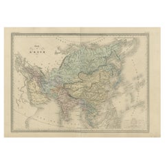
Antique Map of Asia by A
C, Black, 1870
$238.28
$297.8520% Off
£177.02
£221.2820% Off
€200
€25020% Off
CA$330.38
CA$412.9820% Off
A$355.30
A$444.1320% Off
CHF 189.98
CHF 237.4720% Off
MX$4,284.82
MX$5,356.0220% Off
NOK 2,402.42
NOK 3,003.0320% Off
SEK 2,188.92
SEK 2,736.1520% Off
DKK 1,524.33
DKK 1,905.4220% Off
About the Item
Antique map titled 'Asia'. Original antique map of Asia. This map originates from ‘Black's General Atlas of The World’. Published by A
C. Black, 1870.
- Dimensions:Height: 17.52 in (44.5 cm)Width: 23.63 in (60 cm)Depth: 0.02 in (0.5 mm)
- Materials and Techniques:
- Period:
- Date of Manufacture:1870
- Condition:Wear consistent with age and use. General age-related toning. some foxing. Large split on folding line. Please study image carefully.
- Seller Location:Langweer, NL
- Reference Number:Seller: BG-12784-281stDibs: LU3054325446662
About the Seller
5.0
Recognized Seller
These prestigious sellers are industry leaders and represent the highest echelon for item quality and design.
Platinum Seller
Premium sellers with a 4.7+ rating and 24-hour response times
Established in 2009
1stDibs seller since 2017
2,826 sales on 1stDibs
Typical response time: 1 hour
- ShippingRetrieving quote...Shipping from: Langweer, Netherlands
- Return Policy
More From This Seller
View AllAntique Map of Asia by Young, c.1860
Located in Langweer, NL
Antique map titled 'Asia'. Steel engraved map of Asia by Francis Young.
Artists and Engravers: Engraved by Lewis Becker. Published by S.O. Beeton.
We sell original antique maps to...
Category
Antique 19th Century Maps
Materials
Paper

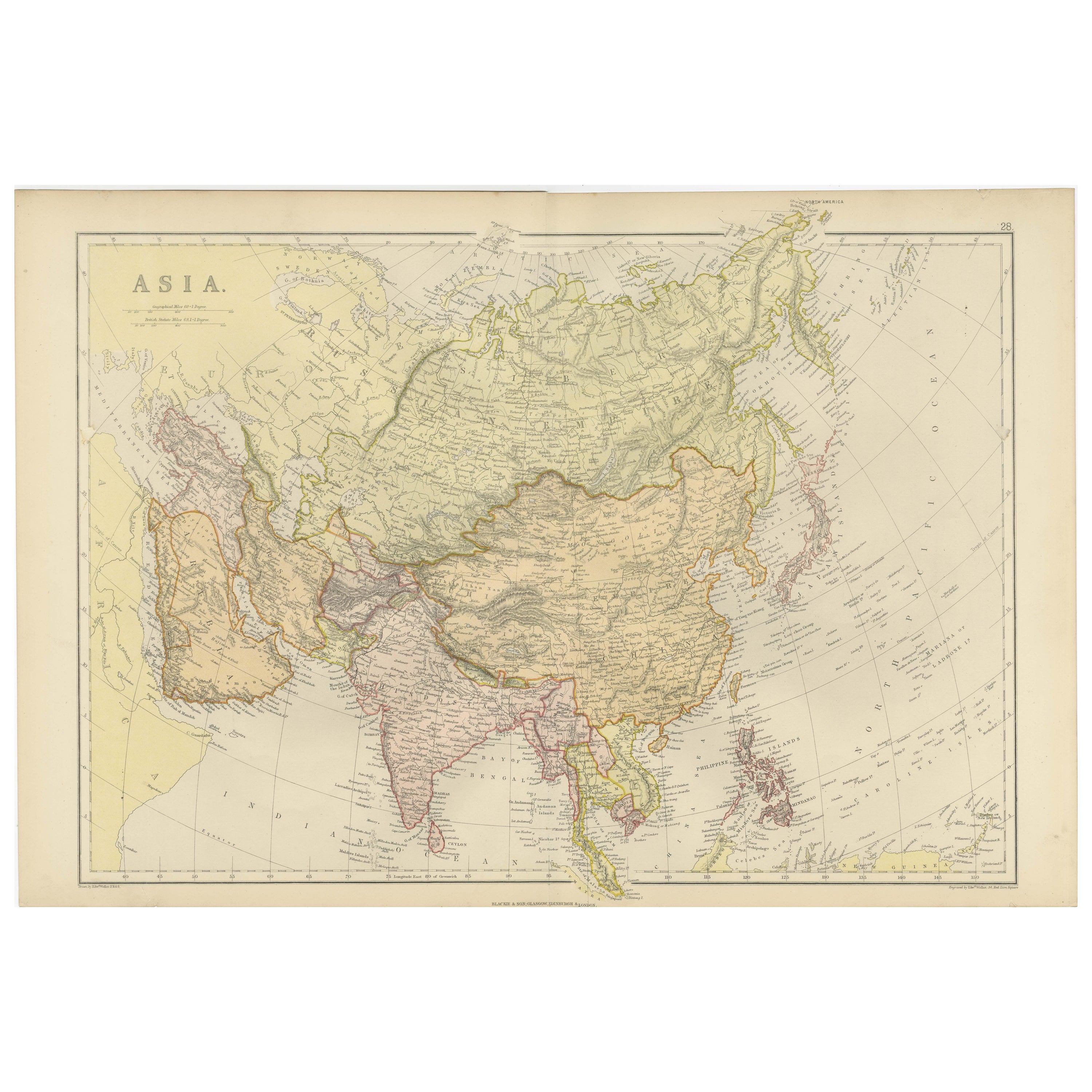
Antique Map of Asia by K. Johnston, circa 1879
Located in Langweer, NL
No. 28 of Keith Johnston's General Atlas. Published by William Blackwood & Sons Edinburgh & London, circa 1879.
Category
Antique Late 19th Century Maps
Materials
Paper

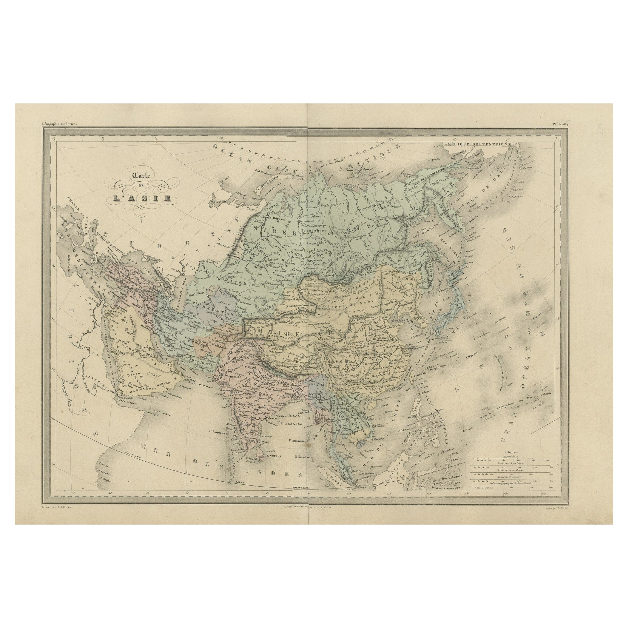
Antique Map of Asia by Malte-Brun, 1880
Located in Langweer, NL
Map Pl. 63 - 64: 'Carte de l'Asie.' This map shows Asia. This original antique map originates from 'Atlas de la Geographie Universelle ou Description de toutes les parties du monde s...
Category
Antique 19th Century Maps
Materials
Paper
Antique Map of Asia by Johnson, 1872
Located in Langweer, NL
Antique map titled 'Johnson's Asia'. Original map of Asia. This map originates from 'Johnson's New Illustrated Family Atlas of the World' by A.J. Johnson. Published, 1872.
Category
Antique Late 19th Century Maps
Materials
Paper

$333 Sale Price
20% Off
Historical Map Depicting the Continent of Asia, 1882
Located in Langweer, NL
This 1882 map presents a meticulously detailed representation of the continent of Asia, a testament to the cartographic skills of the era. Published as a...
Category
Antique 1880s Maps
Materials
Paper

$275 Sale Price
30% Off
Antique Map of Asia from a German School Atlas, c.1870
Located in Langweer, NL
Antique map titled 'Asien'. Old map of the Asian continent. This map originates from 'H. Kiepert's Kleiner Atlas der Neueren Geographie für Schule und Haus'.
Artists and Engravers:...
Category
Antique 19th Century Maps
Materials
Paper

You May Also Like
Antique 1803 Italian Map of Asia Including China Indoneseia India
Located in Amsterdam, Noord Holland
Antique 1803 Italian Map of Asia Including China Indoneseia India
Very nice map of Asia. 1803.
Additional information:
Type: Map
Country of Manufacturing: Europe
Period: 19th centu...
Category
Antique 19th Century European Maps
Materials
Paper

$438 Sale Price
39% Off
Large Original Antique Map of Asia by Sidney Hall, 1847
Located in St Annes, Lancashire
Great map of Asia
Drawn and engraved by Sidney Hall
Steel engraving
Original colour outline
Published by A & C Black. 1847
Unframed
Free shipping
Category
Antique 1840s Scottish Maps
Materials
Paper

Large Original Vintage Map of S.E Asia, with a Vignette of Singapore
Located in St Annes, Lancashire
Great map of South East Asia
Original color. Good condition
Published by Alexander Gross
Unframed.
Category
Vintage 1920s English Maps
Materials
Paper

Original Antique Map of China, Arrowsmith, 1820
Located in St Annes, Lancashire
Great map of China
Drawn under the direction of Arrowsmith
Copper-plate engraving
Published by Longman, Hurst, Rees, Orme and Brown, 1820
Unfr...
Category
Antique 1820s English Maps
Materials
Paper

Original Antique Map of The Eastern Hemisphere by Dower, circa 1835
Located in St Annes, Lancashire
Nice map of the Eastern Hemisphere
Drawn and engraved by J.Dower
Published by Orr & Smith. C.1835
Unframed.
Free shipping
Category
Antique 1830s English Maps
Materials
Paper

Super Rare Antique French Map of Chine and the Chinese Empire, 1780
Located in Amsterdam, Noord Holland
Super Rare Antique French Map of Chine and the Chinese Empire, 1780
Very nice map of Asia. 1780 Made by Bonne.
Additional information:
Type: Map
...
Category
Antique 18th Century European Maps
Materials
Paper

$438 Sale Price
49% Off
More Ways To Browse
Antique Map Of Egypt
Map Of Austria
New Zealand Map
Antique Linen Map
19th Century World Map
Antique Ohio Maps
Antique Texas Furniture
Military Map
Antique Maps New Zealand
Birds Eye View Map
North Africa Map
West Africa Map
Antique Compass Map
Antique Maps California
Biblical Maps
Hungary Map
Maps Of Mediterranean
Treasure Map