Items Similar to Antique Map of Asia with Political Divisions – Black’s Atlas, 1884


Want more images or videos?
Request additional images or videos from the seller
1 of 9
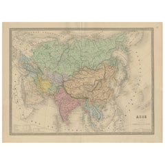
Antique Map of Asia with Political Divisions – Black’s Atlas, 1884
$462.76
£345.47
€390
CA$642.91
A$691.54
CHF 369.58
MX$8,151.30
NOK 4,659.53
SEK 4,259.70
DKK 2,972.24
About the Item
Antique Map of Asia with Political Divisions – Black’s Atlas, 1884
This finely engraved and hand-colored map of Asia was published in the New and Revised Edition of Black’s General Atlas of the World, Edinburgh, 1884. It presents a comprehensive political and geographical view of the Asian continent in the late 19th century, at a moment when imperial influence and global trade networks were rapidly reshaping the region.
The map extends from the eastern Mediterranean and the Middle East across Central Asia to China, Korea, Japan, and Southeast Asia, and from the Arctic regions in the north to the Indian Ocean and the islands of Indonesia in the south. Political boundaries are clearly delineated and enhanced with original hand coloring, distinguishing empires, kingdoms, and colonial territories. The British Raj dominates the Indian subcontinent, while China is shown in its imperial configuration. Russian expansion across Siberia is prominently depicted, stretching from Europe to the Pacific Ocean.
Major rivers, mountain ranges, deserts, and plateaus are finely engraved, including the Himalayas, the Tibetan Plateau, the Gobi Desert, and the great river systems of Asia. Important cities, ports, and trade routes are carefully marked, emphasizing Asia’s central role in global commerce, exploration, and geopolitics during the Victorian era.
This map serves as both a detailed geographic reference and a historical document, illustrating Asia before the political transformations of the 20th century. Its balanced composition, subtle coloring, and high level of detail make it particularly appealing for collectors, scholars, and interior display.
Condition report:
Very good condition. Original hand coloring remains fresh and even. Center fold as issued. Light marginal toning and faint age spotting consistent with atlas maps of this period. Plate mark visible. No tears or losses.
Framing tips:
This map benefits from a wide archival mat in ivory or light cream to emphasize the pastel tones and large scale of the continent. A dark walnut or black frame provides strong contrast, while a gilt frame enhances its late Victorian character. UV-protective glass is recommended to preserve the original coloring.
Technique: Engraving with original hand coloring
Maker: Black’s General Atlas, Edinburgh, 1884
- Dimensions:Height: 17.84 in (45.3 cm)Width: 24.1 in (61.2 cm)Depth: 0.01 in (0.2 mm)
- Materials and Techniques:
- Place of Origin:
- Period:
- Date of Manufacture:1884
- Condition:Very good condition. Original hand coloring remains fresh and even. Center fold as issued. Light marginal toning and faint age spotting consistent with atlas maps of this period. Plate mark visible. No tears or losses.
- Seller Location:Langweer, NL
- Reference Number:Seller: BG-13601-3-201stDibs: LU3054348279612
About the Seller
5.0
Recognized Seller
These prestigious sellers are industry leaders and represent the highest echelon for item quality and design.
Platinum Seller
Premium sellers with a 4.7+ rating and 24-hour response times
Established in 2009
1stDibs seller since 2017
2,836 sales on 1stDibs
Typical response time: 1 hour
- ShippingRetrieving quote...Shipping from: Langweer, Netherlands
- Return Policy
More From This Seller
View AllAntique Map of Asia by A
C, Black, 1870
Located in Langweer, NL
Antique map titled 'Asia'. Original antique map of Asia. This map originates from ‘Black's General Atlas of The World’. Published by A & C. Black, 1870.
Category
Antique Late 19th Century Maps
Materials
Paper

$237 Sale Price
20% Off
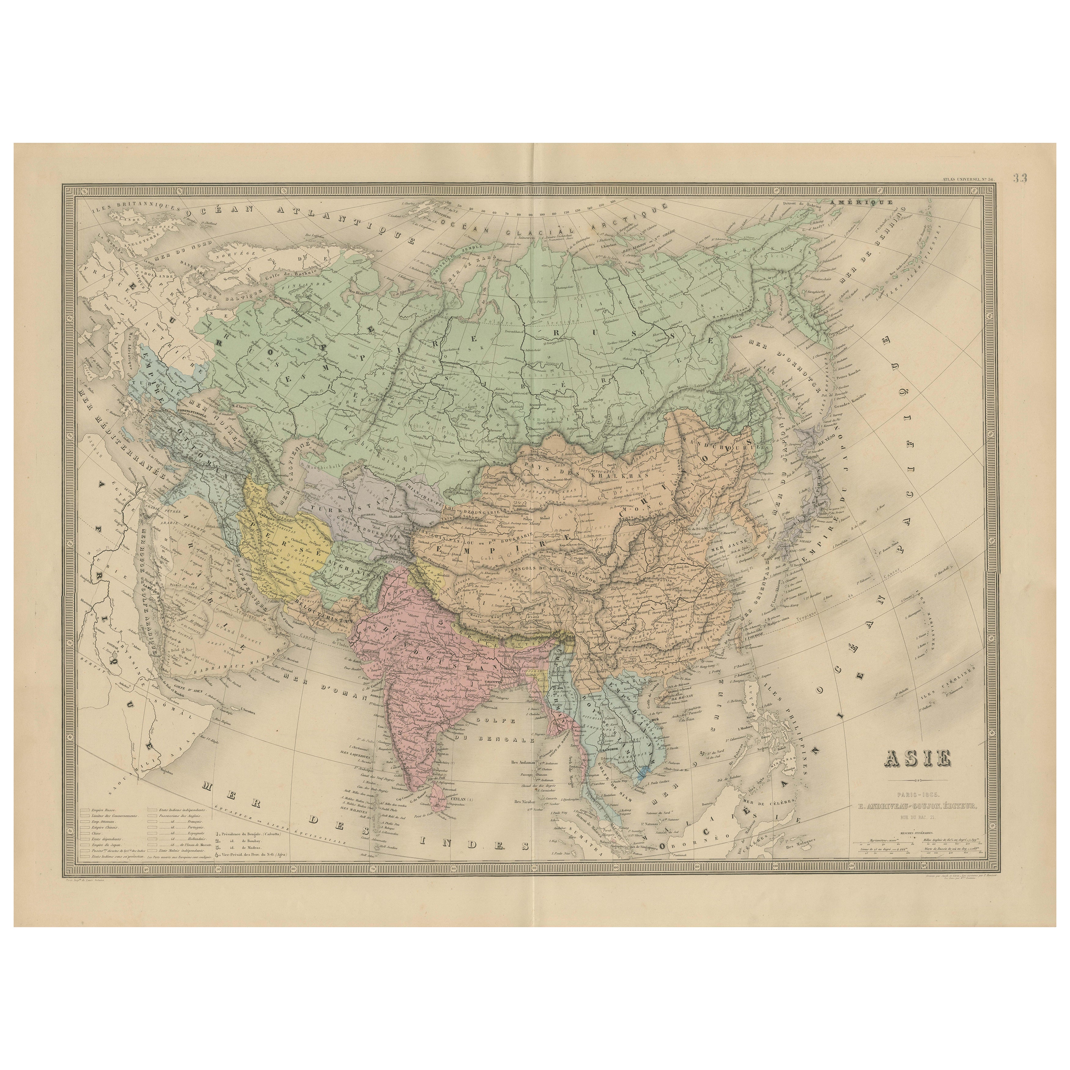
Antique Asia Map – Large 19th-Century Engraving with Political Boundaries, 1865
Located in Langweer, NL
Antique Map of Asia – Andriveau-Goujon, Paris 1865
This large and finely engraved antique map titled “Asie” was published in Paris in 1865 by the prominent French cartographer E. An...
Category
Antique Mid-19th Century French Maps
Materials
Paper
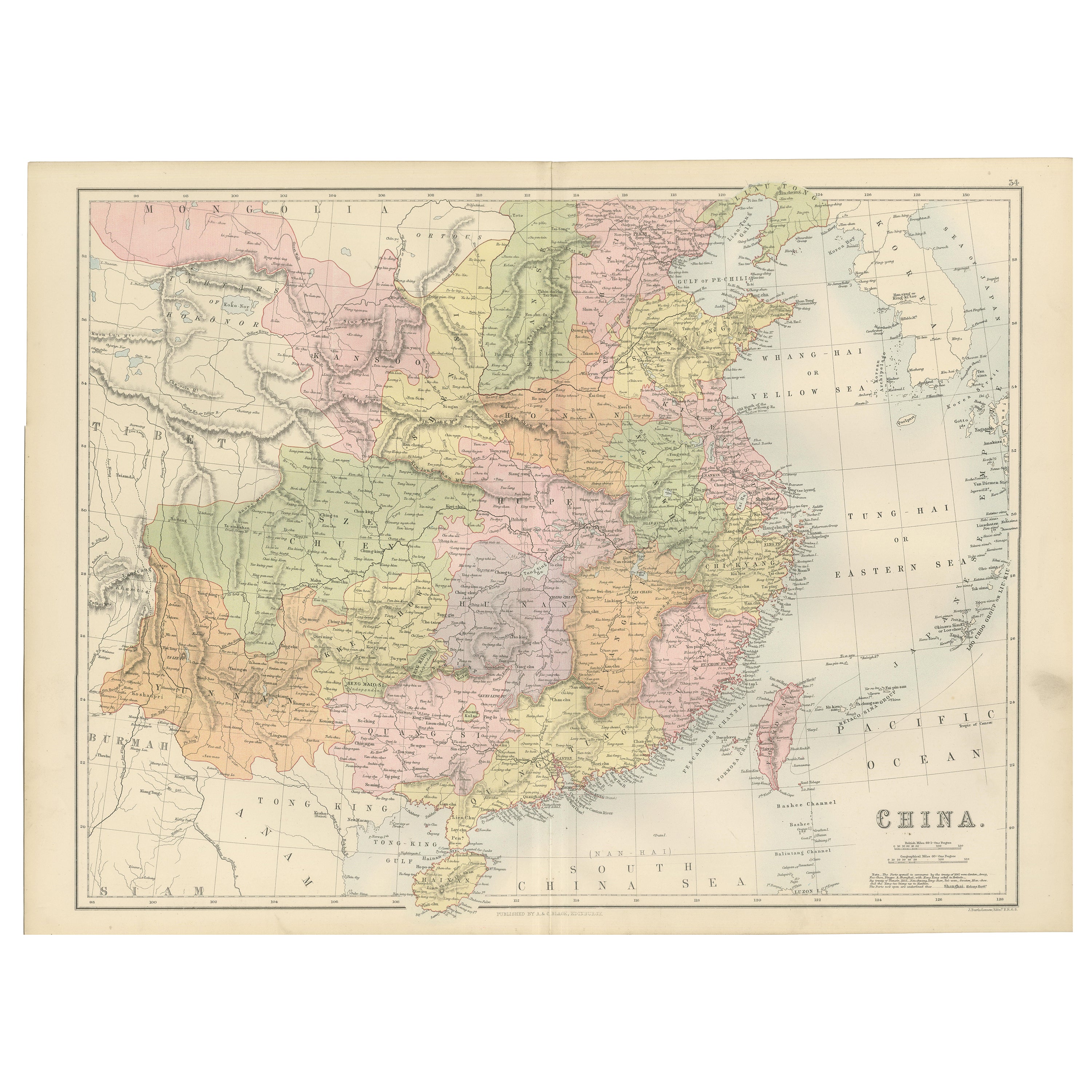
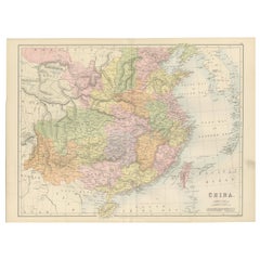
Antique Map of China with Provinces and Treaty Ports – Black’s Atlas, 1884
Located in Langweer, NL
Antique Map of China with Provinces and Treaty Ports – Black’s Atlas, 1884
Description:
This finely engraved and hand-colored map of China was published in the New and Revised Editi...
Category
Antique 1880s Scottish Maps
Materials
Paper
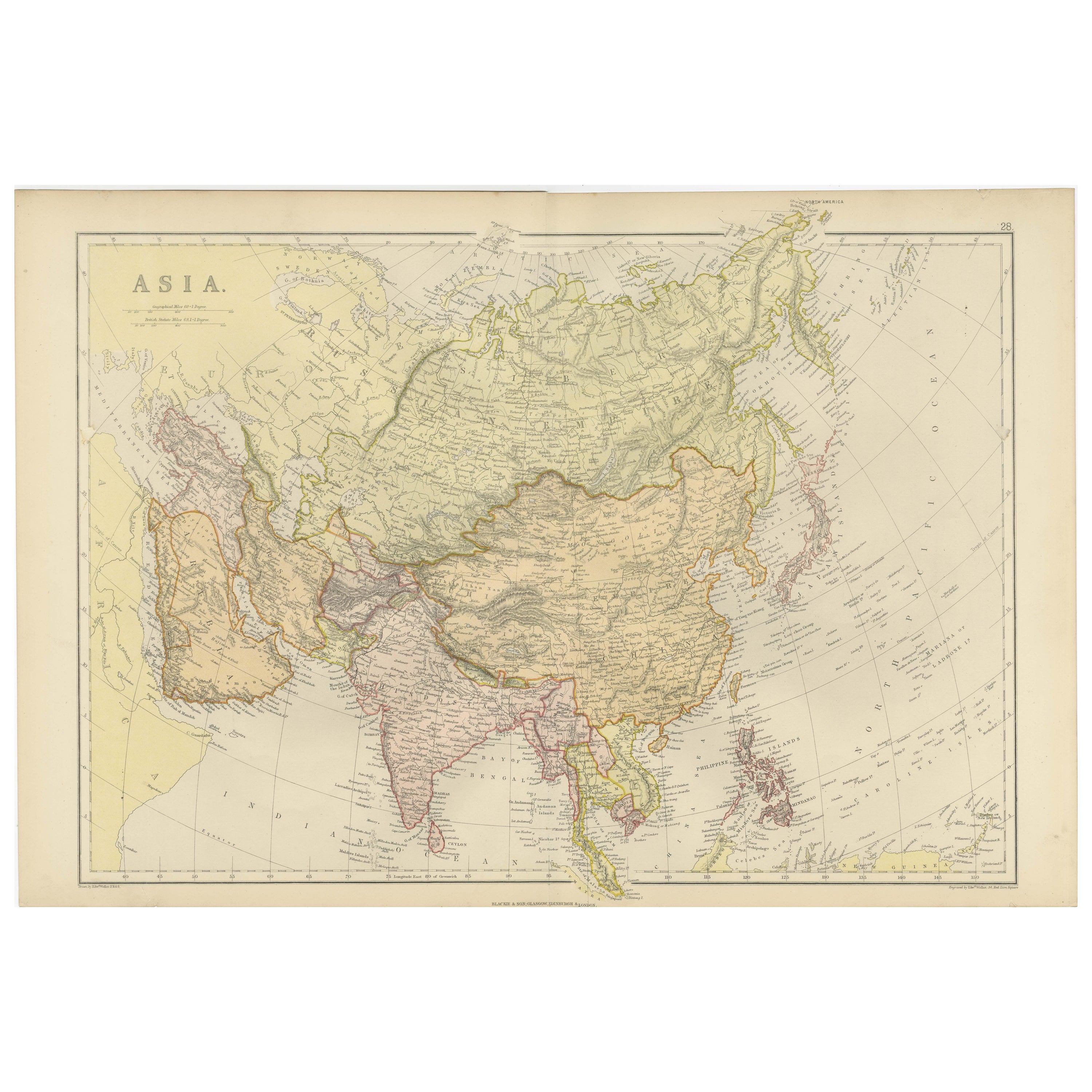
Antique Map of Asia with Intricate Provincial Boundaries, Published in 1903
Located in Langweer, NL
Title: Antique Map of Asia, 1903, with Intricate Provincial Boundaries and Coastal Features
Description:
This antique map, titled "Asia," was engraved and published in 1903 by the r...
Category
Early 20th Century English Maps
Materials
Paper
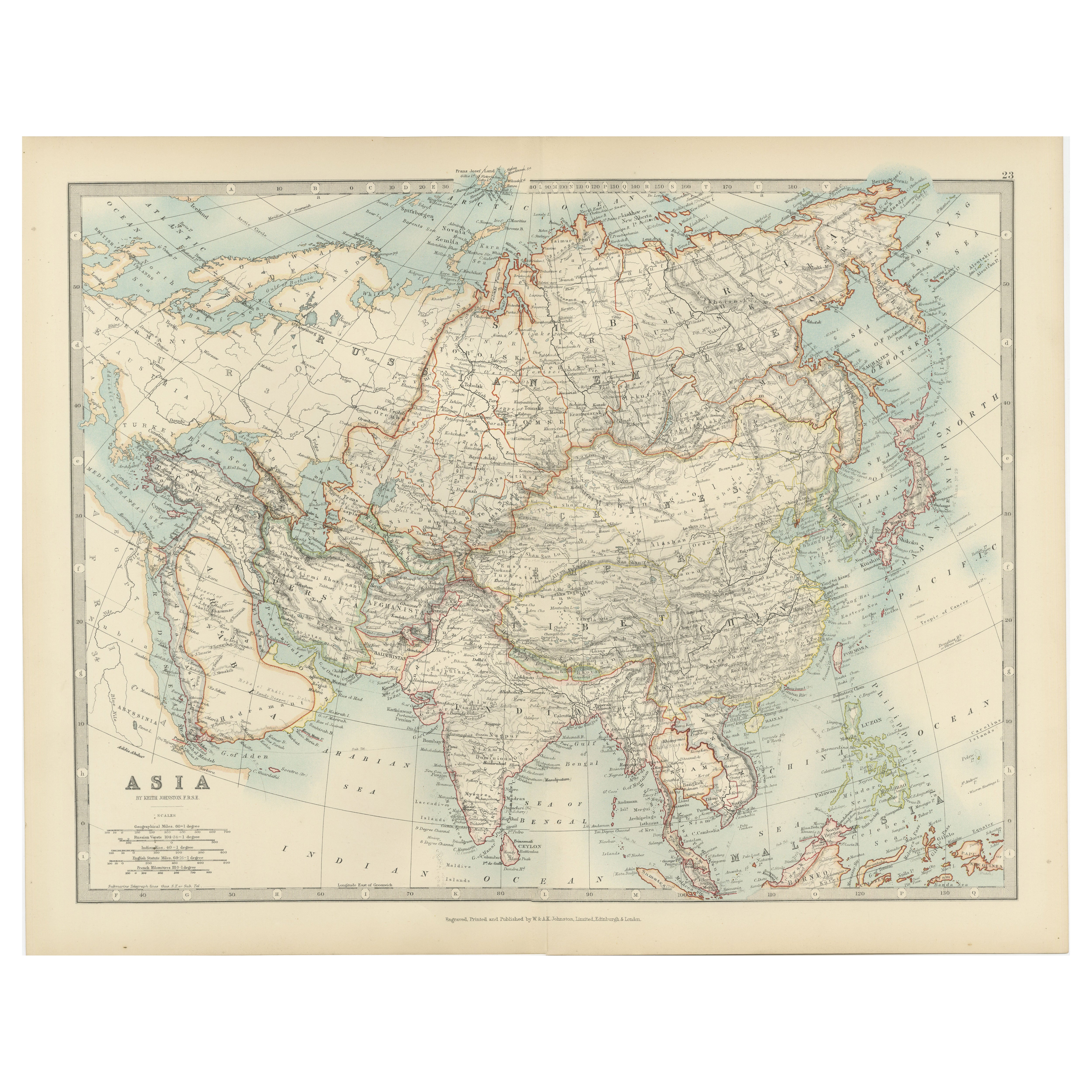
Antique Map of Asia by K. Johnston, circa 1879
Located in Langweer, NL
No. 28 of Keith Johnston's General Atlas. Published by William Blackwood & Sons Edinburgh & London, circa 1879.
Category
Antique Late 19th Century Maps
Materials
Paper

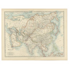
Historical Map Depicting the Continent of Asia, 1882
Located in Langweer, NL
This 1882 map presents a meticulously detailed representation of the continent of Asia, a testament to the cartographic skills of the era. Published as a...
Category
Antique 1880s Maps
Materials
Paper

$274 Sale Price
30% Off
You May Also Like
Large Original Antique Map of Asia by Sidney Hall, 1847
Located in St Annes, Lancashire
Great map of Asia
Drawn and engraved by Sidney Hall
Steel engraving
Original colour outline
Published by A & C Black. 1847
Unframed
Free shipping
Category
Antique 1840s Scottish Maps
Materials
Paper

Original Antique Map of The Eastern Hemisphere by Dower, circa 1835
Located in St Annes, Lancashire
Nice map of the Eastern Hemisphere
Drawn and engraved by J.Dower
Published by Orr & Smith. C.1835
Unframed.
Free shipping
Category
Antique 1830s English Maps
Materials
Paper

Antique 1803 Italian Map of Asia Including China Indoneseia India
Located in Amsterdam, Noord Holland
Antique 1803 Italian Map of Asia Including China Indoneseia India
Very nice map of Asia. 1803.
Additional information:
Type: Map
Country of Manufacturing: Europe
Period: 19th centu...
Category
Antique 19th Century European Maps
Materials
Paper

$438 Sale Price
39% Off
China and Japan, English antique map by Alexander Keith Johnston, 1901
Located in Melbourne, Victoria
'China and Japan', antique lithographic map by Keith Johnston.
Central vertical fold as issued.
495mm by 625mm (sheet)
Alexander Keith Johnston FRS...
Category
Early 20th Century Victorian More Prints
Materials
Lithograph

Original Antique Map of The World by Dower, circa 1835
Located in St Annes, Lancashire
Nice map of the World
Drawn and engraved by J.Dower
Published by Orr & Smith. C.1835
Unframed.
Free shipping
Category
Antique 1830s English Maps
Materials
Paper

Original Antique Map of China, Arrowsmith, 1820
Located in St Annes, Lancashire
Great map of China
Drawn under the direction of Arrowsmith
Copper-plate engraving
Published by Longman, Hurst, Rees, Orme and Brown, 1820
Unfr...
Category
Antique 1820s English Maps
Materials
Paper
