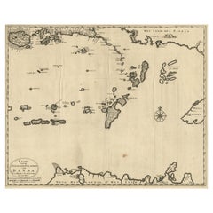
Items Similar to Antique Map of the Banda Islands and the Route of Abel Tasman, Indonesia, 1726

Want more images or videos?
Request additional images or videos from the seller
1 of 6
Antique Map of the Banda Islands and the Route of Abel Tasman, Indonesia, 1726
$404.50
$538.5324% Off
£302.81
£403.1524% Off
€338
€45024% Off
CA$556.84
CA$741.3624% Off
A$608.74
A$810.4524% Off
CHF 322.05
CHF 428.7624% Off
MX$7,284.50
MX$9,698.3024% Off
NOK 4,097.61
NOK 5,455.3924% Off
SEK 3,750.94
SEK 4,993.8624% Off
DKK 2,575.14
DKK 3,428.4524% Off
About the Item
Antique print Indonesia with an image on each side. The first image depicts Ontong Java, one of the largest atolls on earth. On verso: antique map of the Banda Islands. With the route of Abel Tasman. This print originates from 'Oud en Nieuw Oost-Indiën' by F. Valentijn.
Artists and Engravers: François Valentijn (1666-1727), a missionary, worked at Amboina from 1684 to 1694 and 1705 to 1713 and travelled extensively in the VOC's lands.
- Dimensions:Height: 13.39 in (34 cm)Width: 7.88 in (20 cm)Depth: 0 in (0.02 mm)
- Materials and Techniques:
- Period:1720-1729
- Date of Manufacture:1726
- Condition:Wear consistent with age and use. Condition: Good, general age-related toning. Small worm hole outside image. Please study image carefully.
- Seller Location:Langweer, NL
- Reference Number:Seller: BGRN-079 1stDibs: LU3054326936352
About the Seller
5.0
Recognized Seller
These prestigious sellers are industry leaders and represent the highest echelon for item quality and design.
Platinum Seller
Premium sellers with a 4.7+ rating and 24-hour response times
Established in 2009
1stDibs seller since 2017
2,793 sales on 1stDibs
Typical response time: <1 hour
- ShippingRetrieving quote...Shipping from: Langweer, Netherlands
- Return Policy
More From This Seller
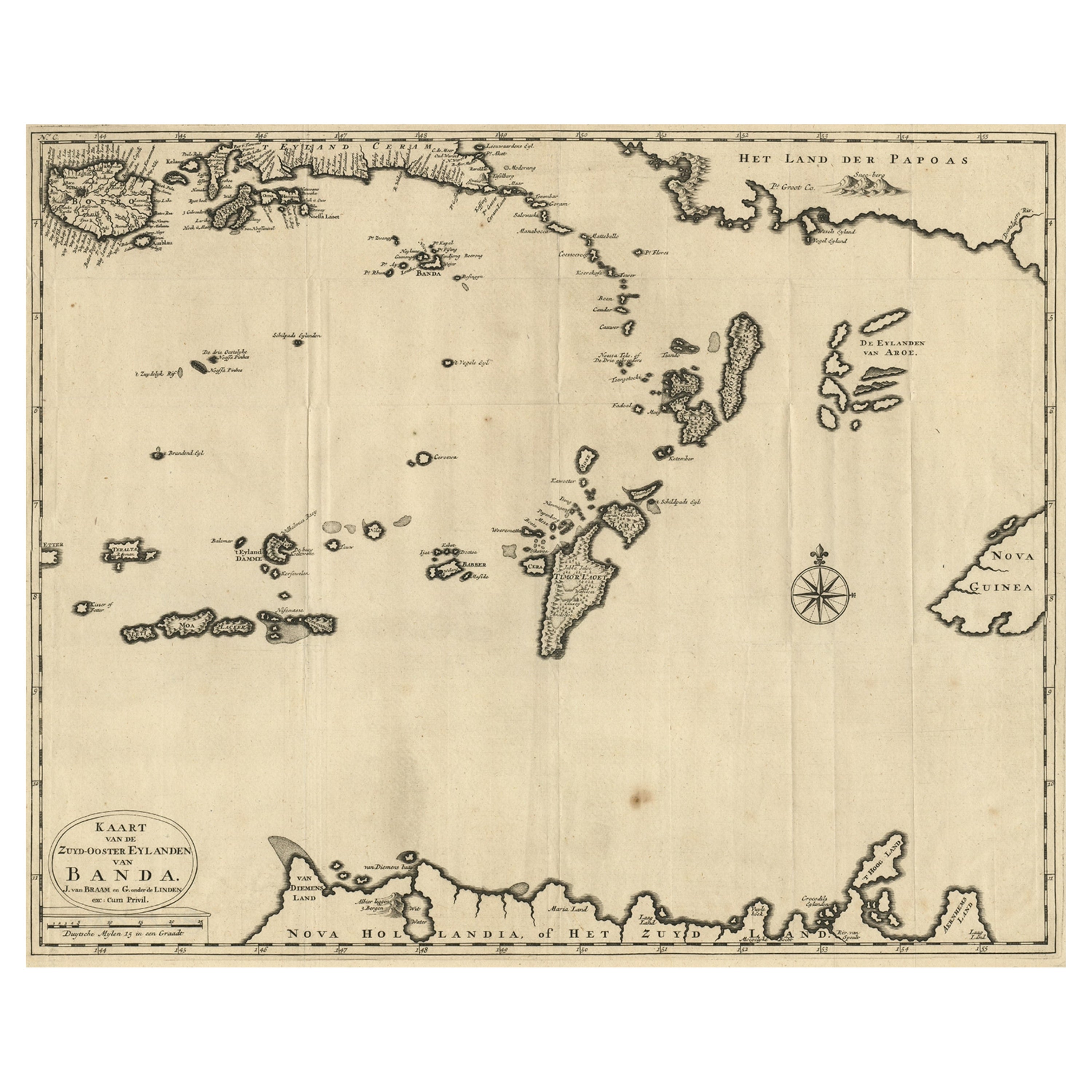
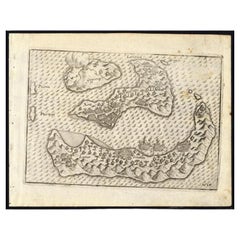
View AllMap of the Southeastern Part of the Banda Islands, Incl Northern Australia, 1726
Located in Langweer, NL
Antique map titled 'Kaart van de Zuyd-Ooster Eylanden van Banda.'
Map of the southeastern part of the Banda islands. This map originates from 'Oud en Nieuw Oost-Indiën' by Franço...
Category
Antique 1720s Maps
Materials
Paper
$1,072 Sale Price
20% Off
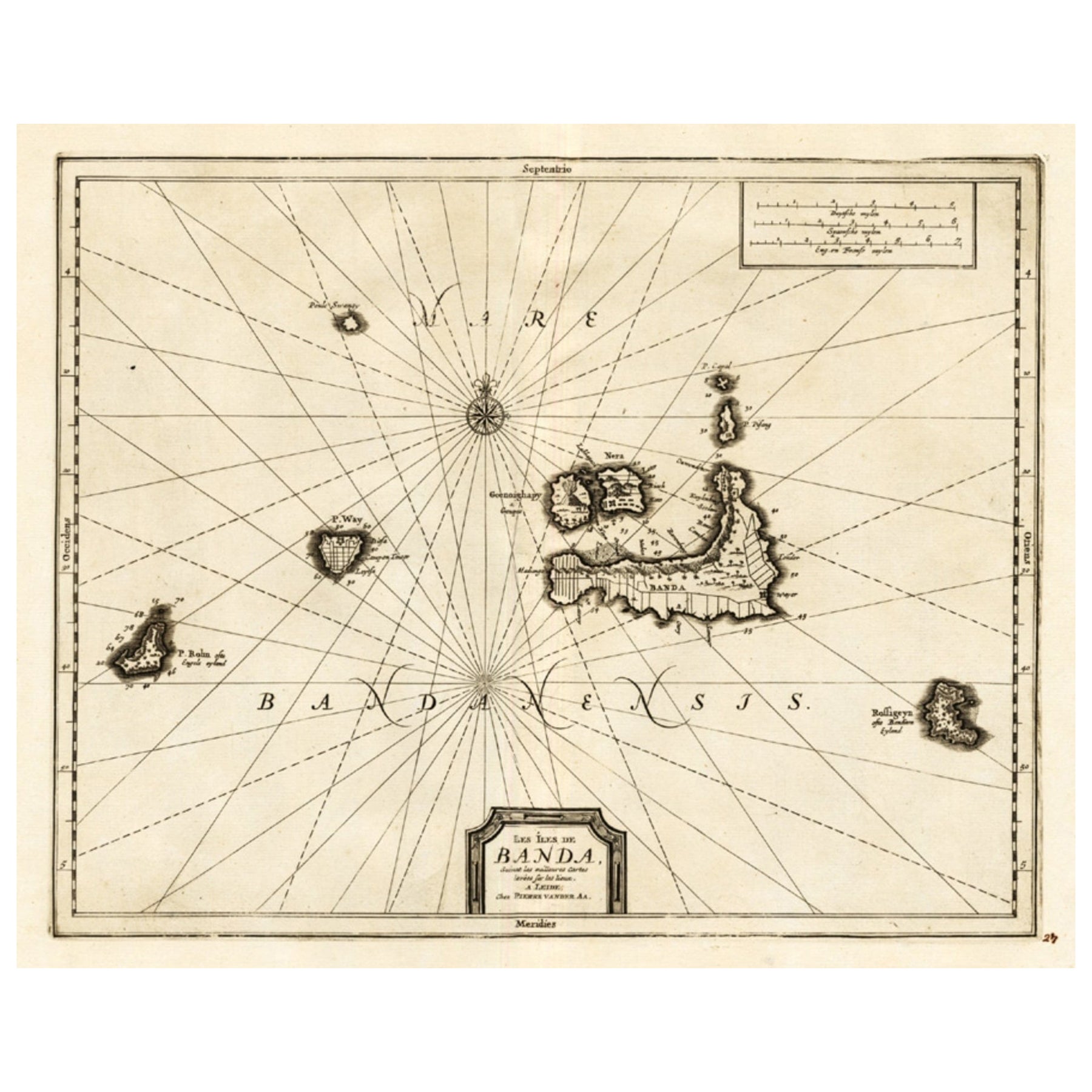
Antique Map of the Islands of Banda, Indonesia from a Very Rare Edition, 1725
Located in Langweer, NL
Antique map titled 'Les Iles de Banda (..).' (The islands of Banda, Indonesia.)
Extremely rare in this edition. This plate originates from the very scarse: 'La galerie agreable d...
Category
Antique 1720s Maps
Materials
Paper

$852 Sale Price
20% Off
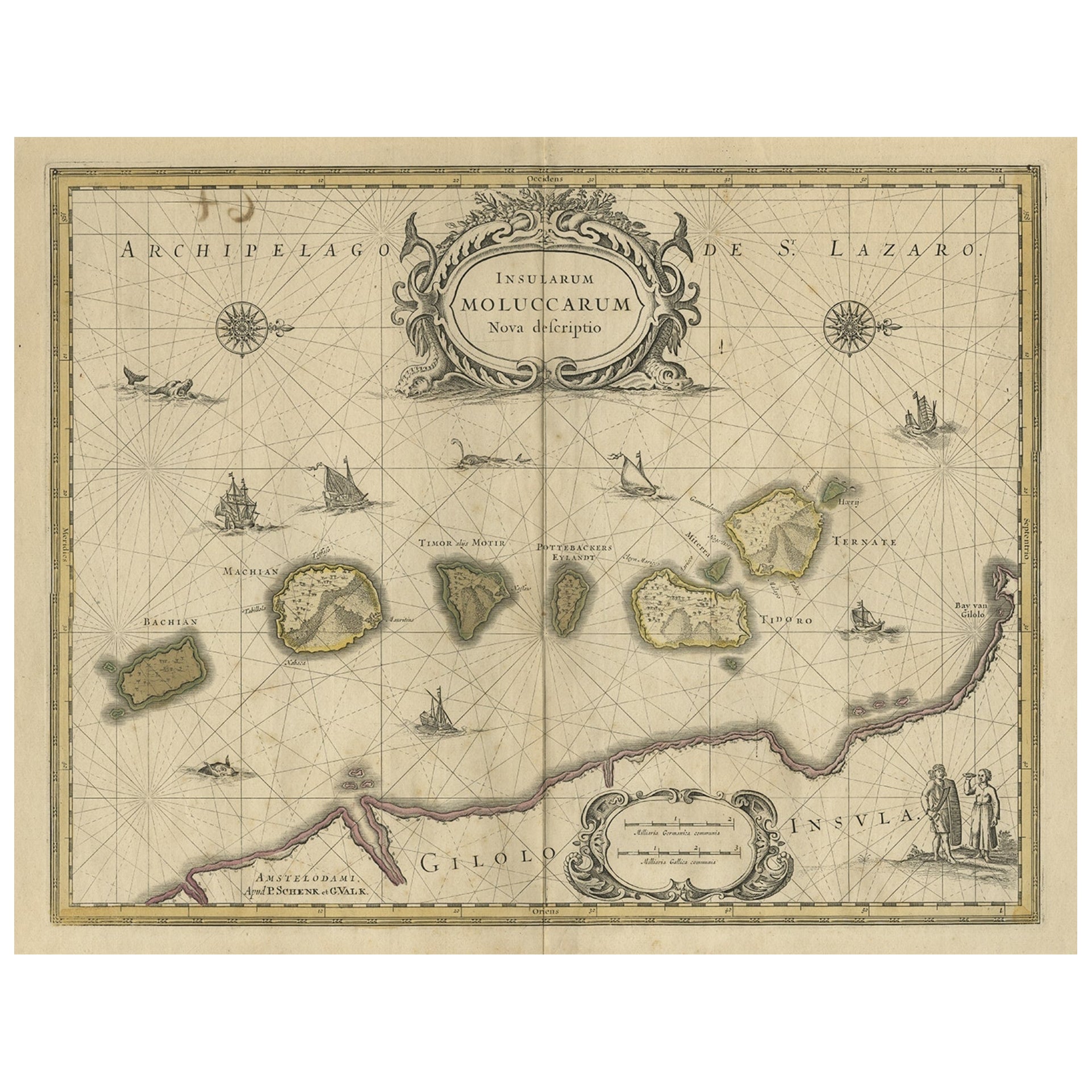
Old Map of the Moluccas, Known as the Famous Spice Islands, Indonesia, ca.1730
Located in Langweer, NL
Antique map titled 'Insularum Moluccarum Nova Descriptio.'
Old map of the Moluccas. The famous Spice Islands, the cornerstone of the Dutch trading empire in the East Indies throughout the 17th Century, is the focus of this exquisite map. Similar to Blaeu's map, except that it extends further south...
Category
Antique 1730s Maps
Materials
Paper

$660 Sale Price
20% Off
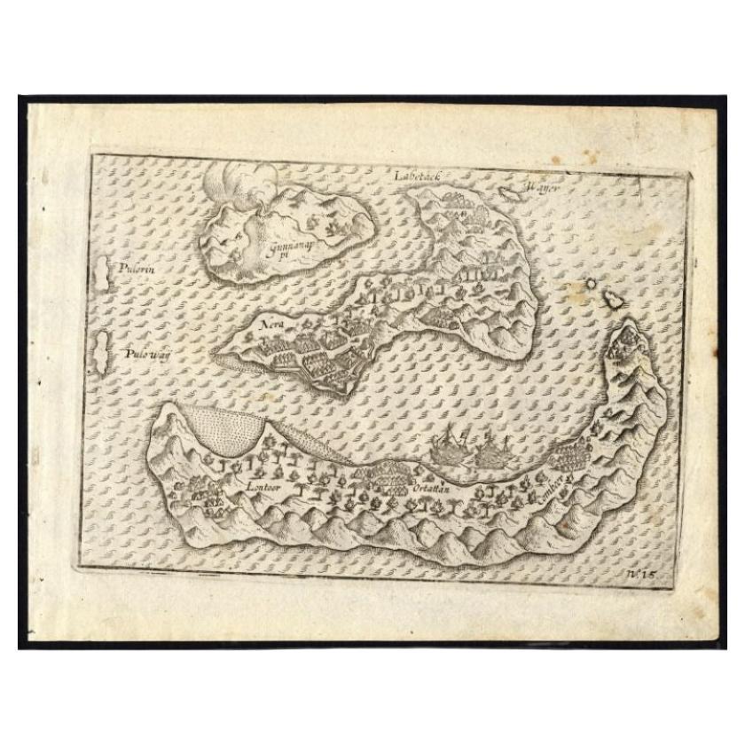
Antique Map of the Banda Islands by Commelin, 1646
Located in Langweer, NL
Plate 15: 'Afteeckeninge van 't Eyland Banda.' Depiction of the Banda Islands, Indonesia. Rare. This attrative plate originates from: 'Title: Waerachtigh verhael van de Schipvaerd op Oost-Indien Ghedaen by de acht Schepen in den jare 1598. van Amsterdam uyt-gezeylt, onder 't beleyd van den Admirael Jacob Cornelissoon van Neck...
Category
Antique 17th Century Maps
Materials
Paper
$337 Sale Price
20% Off
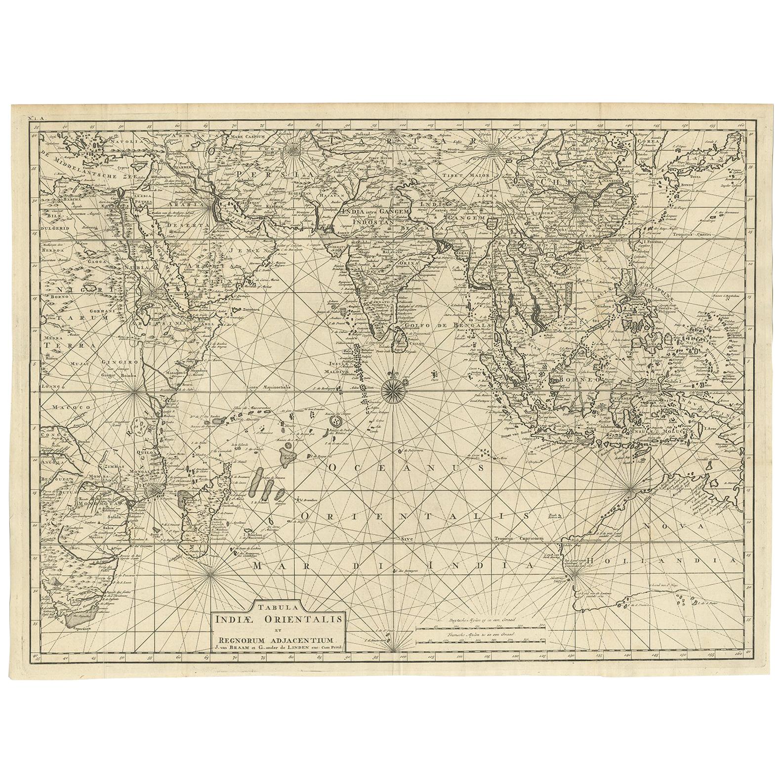
Antique Map of South East Asia, Australia and the Indian Ocean, 1726
By F. Valentijn
Located in Langweer, NL
Antique map titled 'Tabula Indiae Orientalis'.
Beautiful detailed map of Australia, Southeast Asia and the Indian Ocean. The map features a fine depiction of the outlines of the western two-thirds of Australia, based on the discoveries of explorers working for the Dutch East India Company (the VOC). These include Willem Jansz's discoveries in the Gulf of Carpentaria in 1606; the encounters of Dirk...
Category
Antique Mid-18th Century Dutch Maps
Materials
Paper

$6,893 Sale Price
20% Off
Free Shipping
Antique Map of the Island Java, Indonesia, c.1650
Located in Langweer, NL
Antique map titled 'Insulae Iavae cum parte insularum Boreno Sumatrae (..)'.
Beautiful map of the island of Java and part of Borneo, Bali, Madura and Sumatra. With decorative carto...
Category
Antique 17th Century Maps
Materials
Paper

$3,111 Sale Price
20% Off
You May Also Like
Antique Map - Mare Pacificum - Etching by Johannes Janssonius - 1650s
By Johannes Janssonius
Located in Roma, IT
Mare Pacificum is an antique map realized in 1650 by Johannes Janssonius (1588-1664).
The Map is Hand-colored etching, with coeval watercolorang.
Good conditions with slight foxing...
Category
1650s Modern Figurative Prints
Materials
Etching

Original Antique Map of South America. C.1780
Located in St Annes, Lancashire
Great map of South America
Copper-plate engraving
Published C.1780
Two small worm holes to left side of map
Unframed.
Category
Antique Early 1800s English Georgian Maps
Materials
Paper

Map of the East Indies: An Original 18th Century Hand-colored Map by E. Bowen
Located in Alamo, CA
This is an original 18th century hand-colored map entitled "An Accurate Map of the East Indies Exhibiting the Course of the European Trade both on the Continent and Islands" by Emanu...
Category
Mid-18th Century Old Masters Landscape Prints
Materials
Engraving

Original Antique Map of South East Asia by Thomas Clerk, 1817
Located in St Annes, Lancashire
Great map of South East Asia
Copper-plate engraving
Drawn and engraved by Thomas Clerk, Edinburgh.
Published by Mackenzie And Dent, 1817
Unframed.
Category
Antique 1810s English Maps
Materials
Paper

Antique French Map of Asia Including China Indoneseia India, 1783
Located in Amsterdam, Noord Holland
Very nice map of Asia. 1783 Dedie au Roy.
Additional information:
Country of Manufacturing: Europe
Period: 18th century Qing (1661 - 1912)
Condition: Overall Condition B (Good Used)...
Category
Antique 18th Century European Maps
Materials
Paper

$486 Sale Price
40% Off
Map Of The Island Of Cuba - Guillaume Thomas Raynal (1711-1796)
Located in Porto, PT
This historical map of the Island of Cuba was produced in the late 18th century and is taken from an edition of “Atlas de toutes les parties connues du globe terrestre” by the French...
Category
Antique 18th Century Prints
Materials
Glass, Paper

More Ways To Browse
Tennessee Antique Furniture
Used Furniture Alabama
Used Office Furniture Maine
Ancient World Map
Antique Florida Map
Antique Map Chile
Antique Map Of Georgia
Antique Mississippi Furniture
Burgundy Map
John Speed Antique Maps
Malabar Map
Malaysia Map
Map Of Syria
Taiwan Map
Antique Chicago Maps
Dutch Bible
New Jersey 19th Century
Thailand Map