Items Similar to Antique Map of Batavia
Jakarta, Indonesia
by Montanus, 1679

Want more images or videos?
Request additional images or videos from the seller
1 of 11
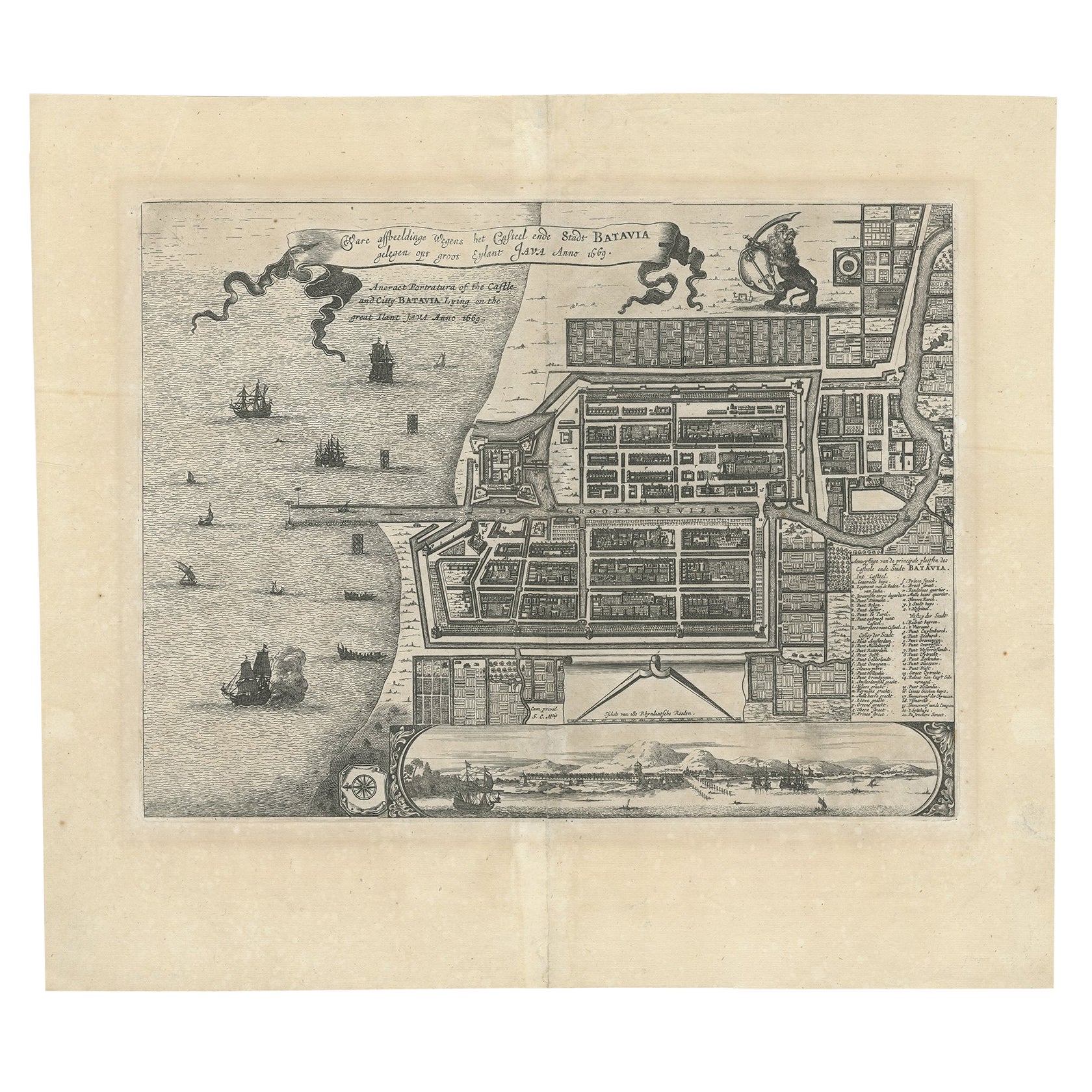
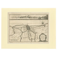
Antique Map of Batavia
Jakarta, Indonesia
by Montanus, 1679
On Hold
$1,263.68
On Hold
£943.40
On Hold
€1,065
On Hold
CA$1,755.64
On Hold
A$1,888.44
On Hold
CHF 1,009.24
On Hold
MX$22,259.32
On Hold
NOK 12,724.11
On Hold
SEK 11,632.25
On Hold
DKK 8,116.50
About the Item
Fine early plan of Batavia (Jakarta), published by Arnoldus Montanus. This map has a vignette at the bottom showing Jakarta from the sea with the volcanoes Mount Gede, Mount Pangrnago and Mount Salak in the background. The plan is based on the earlier, much larger map of Batavia published by Clement de Jonghe in 1650.
- Dimensions:Height: 12.01 in (30.5 cm)Width: 14.89 in (37.8 cm)Depth: 0.02 in (0.5 mm)
- Materials and Techniques:Paper,Engraved
- Place of Origin:
- Period:Late 17th Century
- Date of Manufacture:1679
- Condition:Please study image carefully.
- Seller Location:Langweer, NL
- Reference Number:Seller: BG-040481stDibs: LU305439548573
About the Seller
5.0
Recognized Seller
These prestigious sellers are industry leaders and represent the highest echelon for item quality and design.
Platinum Seller
Premium sellers with a 4.7+ rating and 24-hour response times
Established in 2009
1stDibs seller since 2017
2,836 sales on 1stDibs
Typical response time: 1 hour
- ShippingRetrieving quote...Shipping from: Langweer, Netherlands
- Return Policy
More From This Seller
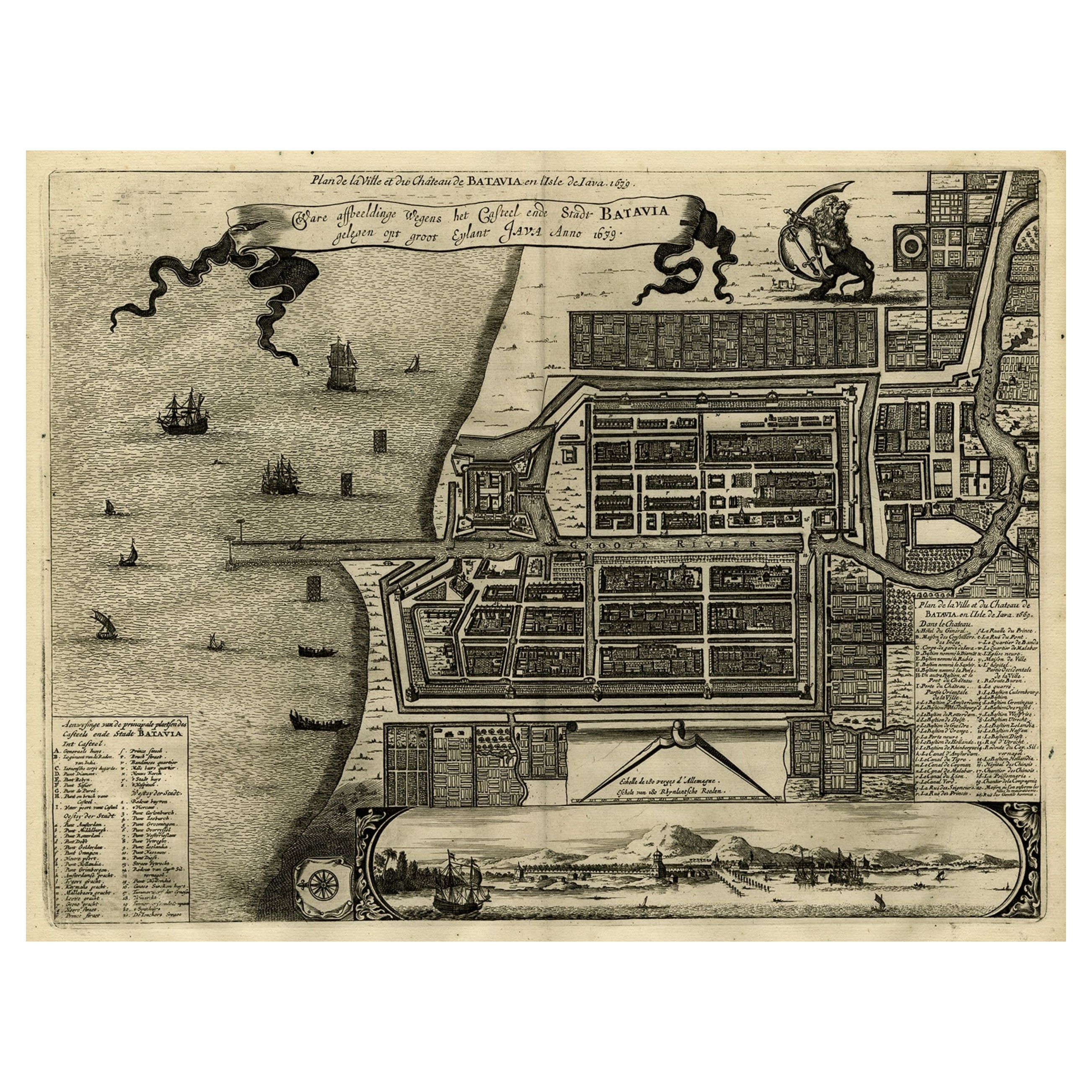
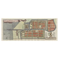
View AllAntique Map of Batavia
Jakarta
, Indonesia by Montanus, circa 1669
Located in Langweer, NL
Antique map Batavia titled 'Ware Affbeeldinge wegens het Casteel ende Stadt Batavia'. Antique print of the castle and city of Batavia on the Island of Java'. Rare edition with Englis...
Category
Antique 17th Century Maps
Materials
Paper

$1,186 Sale Price
20% Off
Antique Map of Batavia, Nowadays Jakarta, the Capital of Indonesia, 1782
Located in Langweer, NL
Antique map Batavia titled 'Batavia zo als het was in den Jaare 1731'. Old map of the city of Batavia (Jakarta) in Indonesia. Originates from 'Batavia, de Hoofdstad van Neerlands O. ...
Category
Antique 18th Century Maps
Materials
Paper
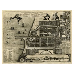
Antique Map of Batavia, Dutch East Indies, Nowadays Jakarta, Indonesia, ca.1669
Located in Langweer, NL
Antique map titled 'Ware afbeeldinge wegens het Casteel ende Stadt Batavia gelegen opt groot Eylant Java Anno 1679. Plan de la Ville et du Chateau de Batavia en l'Isle de Iava. 1679....
Category
Antique 1660s Maps
Materials
Paper
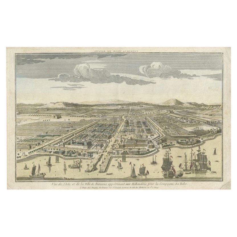
Antique Print of Batavia or nowadays Jakarta, Indonesia, c.1755
Located in Langweer, NL
Antique print titled 'Vue de l'Isle et de la ville de Batavia appartenant aux Hollandois'. Beautiful view of the island and the city of Batavia belonging to the Dutch, for the India ...
Category
Antique 18th Century Prints
Materials
Paper
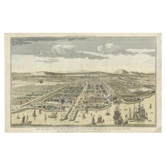
$692 Sale Price
20% Off
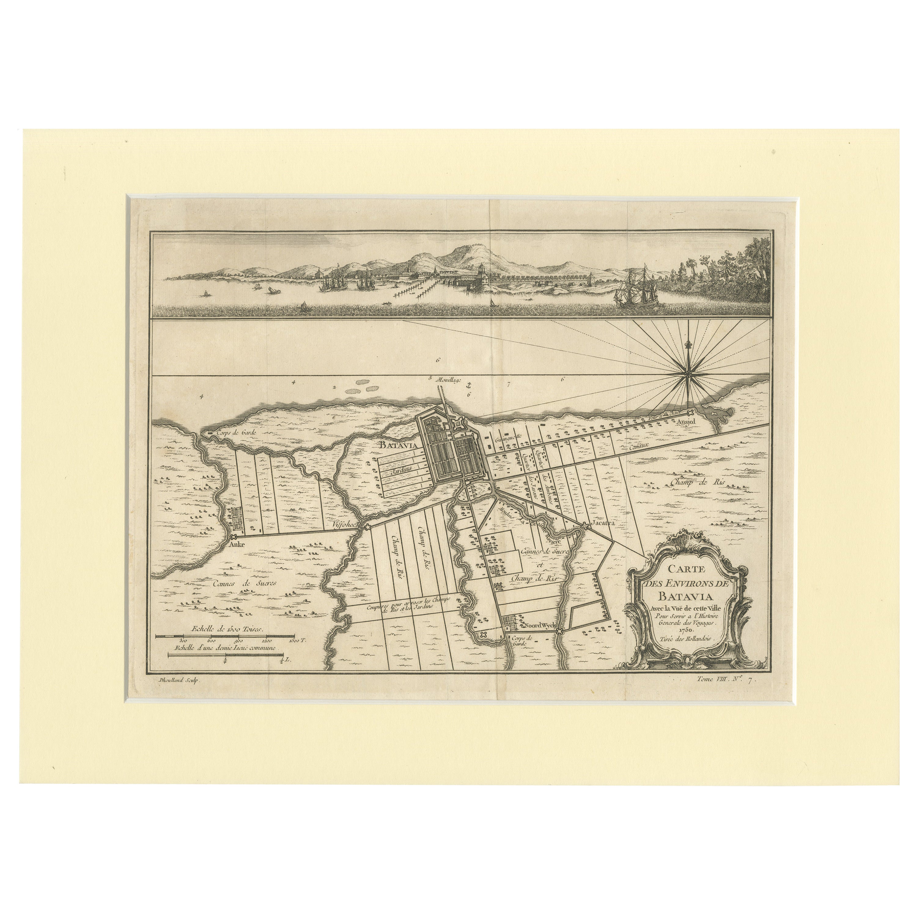
Old Engraving of Batavia
Jakarta, Indonesia
with Map and Harbour View, 1750
Located in Langweer, NL
Antique map titled 'Carte des environs de Batavia '. French map of the Batavia area (Jakarta) in Indonesia. With cartouche, scale and compass rose. Published circa 1750.
The map i...
Category
Antique 1750s Maps
Materials
Paper
$522 Sale Price
20% Off
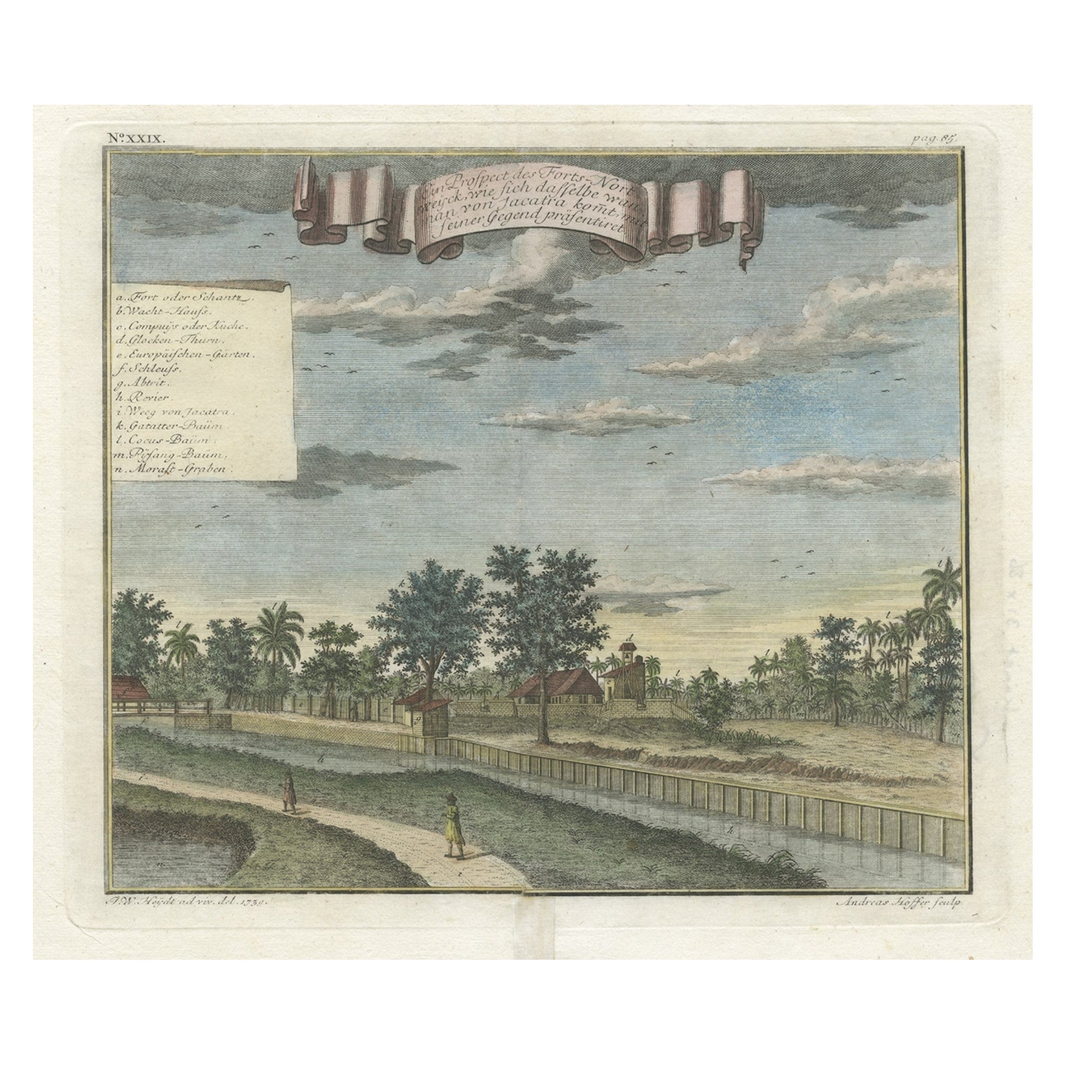
Old Antique Print of Fort Noordwijk, Batavia
Jakarta, Indonesia
, 1739
Located in Langweer, NL
Antique print titled 'Ein Prospect des Forts Nortweijck, wie sich dasselbe wan man von Jacatra komt, mit seiner Gegend präsentiret'.
Old print of Fort Noordwijk, Batavia (Jakarta)....
Category
Antique 1730s Prints
Materials
Paper
$740 Sale Price
20% Off
You May Also Like
Antique Map of Principality of Monaco
By Antonio Vallardi Editore
Located in Alessandria, Piemonte
ST/619 - "Old Geographical Atlas of Italy - Topographic map of ex-Principality of Monaco" -
ediz Vallardi - Milano -
A somewhat special edition ---
Category
Antique Late 19th Century Italian Other Prints
Materials
Paper

$360 Sale Price
62% Off
Original Antique Map of Sweden, Engraved by Barlow, 1806
Located in St Annes, Lancashire
Great map of Sweden
Copper-plate engraving by Barlow
Published by Brightly & Kinnersly, Bungay, Suffolk. 1806
Unframed.
Category
Antique Early 1800s English Maps
Materials
Paper

Original Antique Map of The World by Thomas Clerk, 1817
Located in St Annes, Lancashire
Great map of The Eastern and Western Hemispheres
On 2 sheets
Copper-plate engraving
Drawn and engraved by Thomas Clerk, Edinburgh.
Published by Mackenzie And Dent, 1817
...
Category
Antique 1810s English Maps
Materials
Paper

Original Antique Map of Europe, Arrowsmith, 1820
Located in St Annes, Lancashire
Great map of Europe
Drawn under the direction of Arrowsmith.
Copper-plate engraving.
Published by Longman, Hurst, Rees, Orme and Brown, 1820
...
Category
Antique 1820s English Maps
Materials
Paper

Original Antique Map of Hungary, Arrowsmith, 1820
Located in St Annes, Lancashire
Great map of Hungary
Drawn under the direction of Arrowsmith.
Copper-plate engraving.
Published by Longman, Hurst, Rees, Orme and Brown, 1820
Unframed.
Category
Antique 1820s English Maps
Materials
Paper

Original Antique Map of Ireland- Kerry. C.1840
Located in St Annes, Lancashire
Great map of Kerry
Steel engraving
Drawn under the direction of A.Adlard
Published by How and Parsons, C.1840
Unframed.
Category
Antique 1840s English Maps
Materials
Paper

More Ways To Browse
Indonesian Antiques
Indonesia Jakarta
Charles Rennie Mackintosh For Cassina
Glass Salt
Vintage Resin Tables
Antique English Country Furniture
Blue Kilim Vintage
Contemporary Side Tables And Stools
Decorative Wall Plate
Mid Century Modern Corner Chair
Dining Tables With Brass Inlay
Oak Mid Century Armchair
Solid Wood Side Table Stool
Antique Marble Top Hall Table
Bird And Butterfly
Old Carpet
Porcelain Modern Hand Painted
Bent Plywood