Items Similar to Antique Map of Batavia and Surabaya by Winkler Prins, 1905

Want more images or videos?
Request additional images or videos from the seller
1 of 5
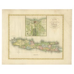
Antique Map of Batavia and Surabaya by Winkler Prins, 1905
$165.65
£122.69
€137.94
CA$226.60
A$246.61
CHF 130.73
MX$2,966.96
NOK 1,658.07
SEK 1,517.02
DKK 1,051.13
About the Item
Antique map titled 'Batavia en Soerabaja'. Detailed plan of Batavia (Jakarta) and Soerabaja (Surabaya), Indonesia. The plans include important places like Tandjoeng Priok, Oedjong, Weltevreden, Ngampel, Keta Bang, Goebeng, Koepang, Goen Sari and Wanakrama.
- Dimensions:Height: 9.89 in (25.1 cm)Width: 12.52 in (31.8 cm)Depth: 0.02 in (0.5 mm)
- Materials and Techniques:
- Period:
- Date of Manufacture:1905
- Condition:Wear consistent with age and use. Please study images carefully.
- Seller Location:Langweer, NL
- Reference Number:Seller: BG-121521stDibs: LU3054316726621
About the Seller
5.0
Recognized Seller
These prestigious sellers are industry leaders and represent the highest echelon for item quality and design.
Platinum Seller
Premium sellers with a 4.7+ rating and 24-hour response times
Established in 2009
1stDibs seller since 2017
2,813 sales on 1stDibs
Typical response time: 1 hour
- ShippingRetrieving quote...Shipping from: Langweer, Netherlands
- Return Policy
More From This Seller
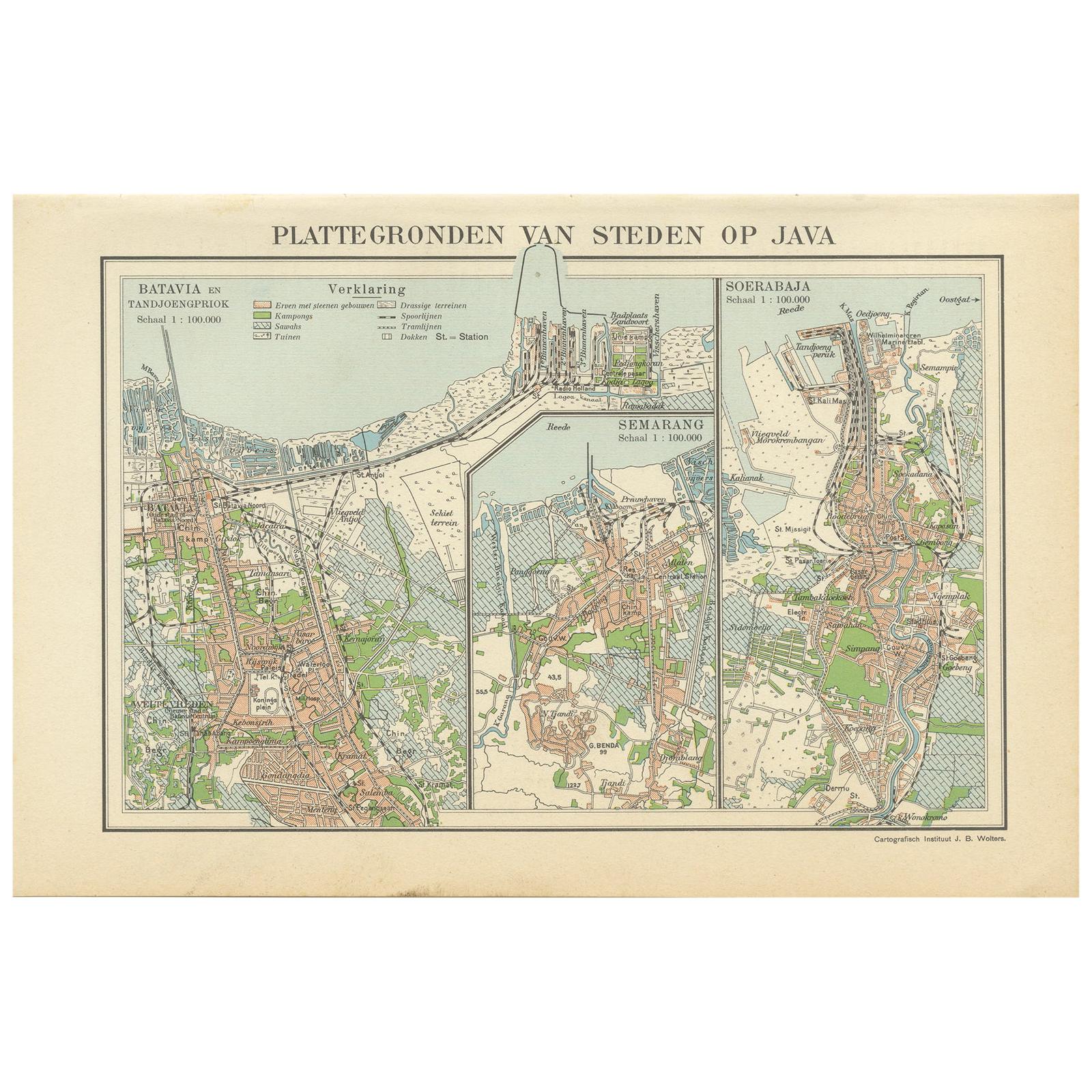
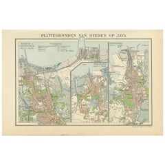
View AllAntique Map of Batavia, Semarang and Surabaya by Wolters
circa 1910
Located in Langweer, NL
Antique map titled 'Plattegronden van Steden op Java'. Old map with plans of Batavia (Jakarta), Semarang and Surabaya (Soerabaja)'. Published by J.B. Wolters.
Category
20th Century Maps
Materials
Paper
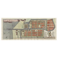
Antique Map of Batavia, Nowadays Jakarta, the Capital of Indonesia, 1782
Located in Langweer, NL
Antique map Batavia titled 'Batavia zo als het was in den Jaare 1731'. Old map of the city of Batavia (Jakarta) in Indonesia. Originates from 'Batavia, de Hoofdstad van Neerlands O. ...
Category
Antique 18th Century Maps
Materials
Paper
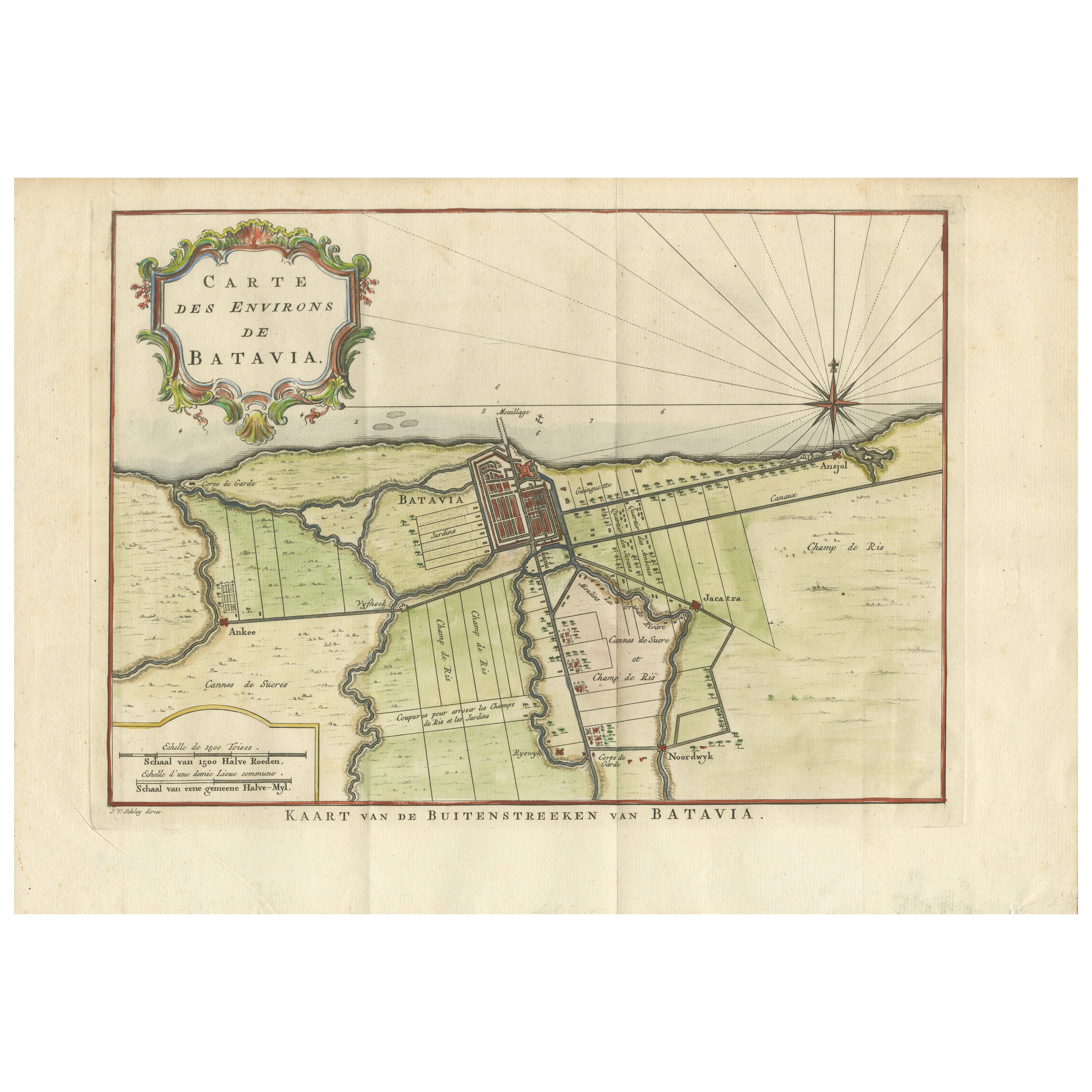
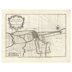
Map of Batavia’s Surroundings with Early Reference to Jakarta, Indonesia, c.1770
Located in Langweer, NL
Map of Batavia’s Surroundings with Early Reference to Jakarta, circa 1770
Description:
This finely engraved map titled "Carte des Environs de Batavia" offers a compelling and histor...
Category
Antique Late 18th Century Dutch Maps
Materials
Paper
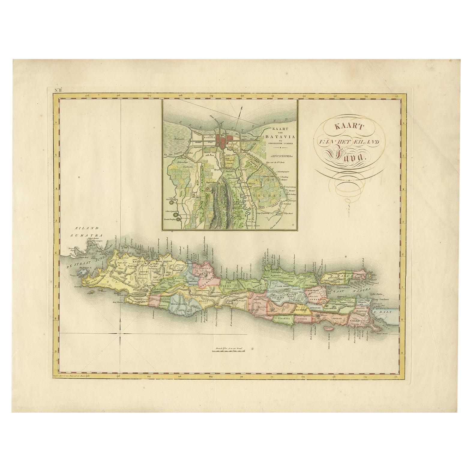
Antique Map of Java and Batavia of nowadays Indonesia,
1818
Located in Langweer, NL
Antique map titled 'Kaart van het Eiland Java'. A rare and attractive early 19th century Dutch map of Java with a large inset map of Batavia. One of 12 maps from 'Atlas van Overzeesc...
Category
Antique Early 19th Century Maps
Materials
Paper
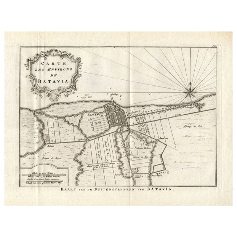
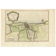
Antique Map of the Region of Batavia by Conrade, 1782
Located in Langweer, NL
Antique map titled 'Carte des environs de Batavia.' (Map of Batavia and its surroundings.) Map of the Batavia area (Jakarta) in Indonesia. With cartouche, scale and compass rose. Thi...
Category
Antique 18th Century Maps
Materials
Paper
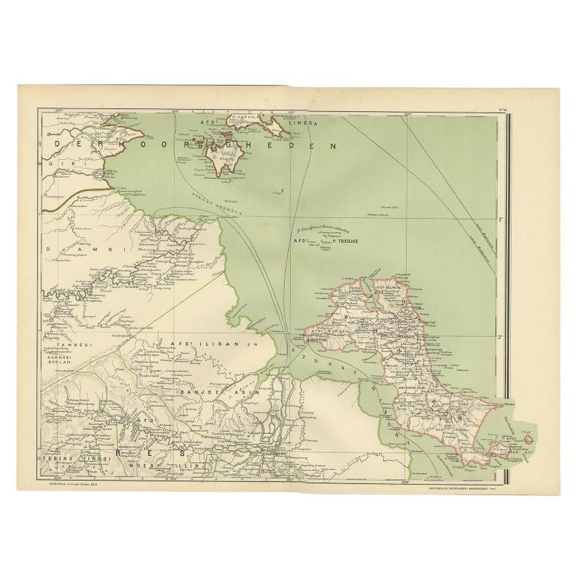
Antique Map of the Region of Banjarmasin, Indonesia 1900
Located in Langweer, NL
Antique Map of the Region of Banyuasin, Sumatra. Also depicting Bangka/Banka island. This map originates from 'Atlas van Nederlandsch Oost- en West-Indië' by I. Dornseiffen.
Artist...
Category
20th Century Maps
Materials
Paper

You May Also Like
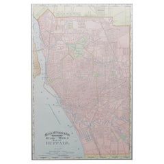
Original Antique City Plan of Buffalo, New York, USA, circa 1900
By Rand McNally
Co.
Located in St Annes, Lancashire
Fabulous colorful map of Buffalo
Original color
By Rand, McNally & Co.
Published, circa 1900
Unframed
Minor edge tears
Free shipping.
Category
Antique 1890s American Maps
Materials
Paper
Original Antique Map of the American State of Michigan ( Northern Part ), 1903
Located in St Annes, Lancashire
Antique map of Michigan ( Northern part )
Published By A & C Black. 1903
Original colour
Good condition
Unframed.
Free shipping
Category
Antique Early 1900s English Maps
Materials
Paper

Original Antique Map or City Plan of Rome, Italy. Circa 1835
Located in St Annes, Lancashire
Nice map of Rome
Drawn and engraved by J.Dower
Published by Orr & Smith. C.1835
Unframed.
Free shipping
Category
Antique 1830s English Maps
Materials
Paper

Large Original Antique Map of Java and Borneo, Fullarton, C.1870
Located in St Annes, Lancashire
Great map of Java and Borneo
Wonderful figurative borders
From the celebrated Royal Illustrated Atlas
Lithograph. Original color.
Published by Fullarton, Edinburgh. C.1870
Unfr...
Category
Antique 1870s Scottish Maps
Materials
Paper

Original Antique Map of the American State of Illinois ( Southern Part ), 1903
Located in St Annes, Lancashire
Antique map of Illinois ( Southern part )
Published By A & C Black. 1903
Original colour
Good condition
Unframed.
Free shipping
Category
Antique Early 1900s English Maps
Materials
Paper

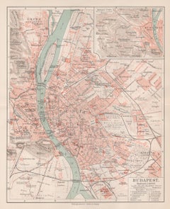
Budapest, Hungary. Antique Map City Plan Chromolithograph, circa 1901.
Located in Melbourne, Victoria
'Budapest'
Colour lithograph. 1901.
305mm by 240mm (sheet).
Late 19th century German lithograph plan of Budapest, Hungary.
Central horizontal fold.
Category
Late 19th Century Victorian More Prints
Materials
Lithograph
More Ways To Browse
Antique Atlas Furniture
Antique Maps Indonesia
Map Of India
China Map
Victorian Furniture 1920
Antique Maps Amsterdam
Antique Maps Of Russia
19th Century Map Of Africa
Map Of Britain
Antique Oregon
Bali Wood
Railroad Furniture
Antique Malaysia
Blaeu Maps
Antique Topographic Maps
Antique Maps Of North America
Antique Maps Of Italy
Antique Navigator