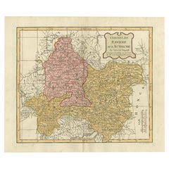
Items Similar to Antique Map of Bavaria and Salzburg by Cary, 1811


Want more images or videos?
Request additional images or videos from the seller
1 of 5
Antique Map of Bavaria and Salzburg by Cary, 1811
$297.85
£221.28
€250
CA$412.98
A$444.13
CHF 237.47
MX$5,356.02
NOK 3,003.03
SEK 2,736.15
DKK 1,905.42
About the Item
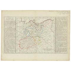
Antique map titled 'A New Map of the Circle of Bavaria'. Antique map of Bavaria and Salzburg, Germany. Covers the Duchy of Bavaria and the mountainous Archbishopric of Salzburg as well as parts of Franconia, Swabia, Tyrol, Bohemia and Austria.
- Creator:John Cary (Artist)
- Dimensions:Height: 21.46 in (54.5 cm)Width: 24.81 in (63 cm)Depth: 0.02 in (0.5 mm)
- Materials and Techniques:
- Period:
- Date of Manufacture:1811
- Condition:General age-related toning. Original coloring, please study images carefully.
- Seller Location:Langweer, NL
- Reference Number:Seller: BG-12211-41stDibs: LU3054317045891
John Cary
John Cary was an English cartographer. He was born in February of 1755 and died in August of 1835. His career started with his apprenticeship in London, and he opened up his own shop in the Strand in 1783. His atlas New and Correct English Atlas became the standard reference work in England. He was commissioned in 1794 by the Postmaster General to survey England's roads. Out of this commission, he published Cary's New Itinerary in 1798. He later produced Ordnance Survey maps before 1805. His business was eventually taken over by G.F. Cruchley.
About the Seller
5.0
Recognized Seller
These prestigious sellers are industry leaders and represent the highest echelon for item quality and design.
Platinum Seller
Premium sellers with a 4.7+ rating and 24-hour response times
Established in 2009
1stDibs seller since 2017
2,826 sales on 1stDibs
Typical response time: 1 hour
- ShippingRetrieving quote...Shipping from: Langweer, Netherlands
- Return Policy
More From This Seller
View AllAntique Map of Franconia, a region of Germany,
1811
By John Cary
Located in Langweer, NL
Antique map titled 'A New Map of the Circle of Franconia'. Detailed map of Franconia in Northwestern Germany. Covers from Upper Saxony south to Swabia, west to the Lower Rhine and we...
Category
Antique Early 19th Century Maps
Materials
Paper

Antique Map of the Upper and Lower Rhine by Cary, 1811
By John Cary
Located in Langweer, NL
Antique map titled 'A New Map of the Circles of the Upper and Lower Rhine'. Antique map covering an area from Westphalia and Lower Saxony in the north to France and Swabia in the south.
Category
Antique Early 19th Century British Maps
Materials
Paper

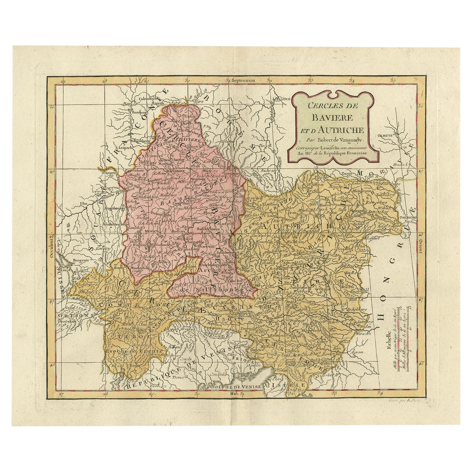
Antique Map of Bavaria in Southern Germany and Austria, 1806
Located in Langweer, NL
Antique map titled 'Cercles de Baviere et d'Autriche.' This map shows Bavaria in southern Germany and Austria. By Robert de Vaugondy, revised and published by Delamarche. Source unkn...
Category
Antique 19th Century Maps
Materials
Paper
Antique Map of Lower Saxony by Clouet, 1787
Located in Langweer, NL
Antique map titled 'Basse Saxe'. Antique map of Lower Saxony, Germany. Originates from 'Geographie moderne avec une introduction' by J.B.L. Clouet.
Category
Antique Late 18th Century Maps
Materials
Paper

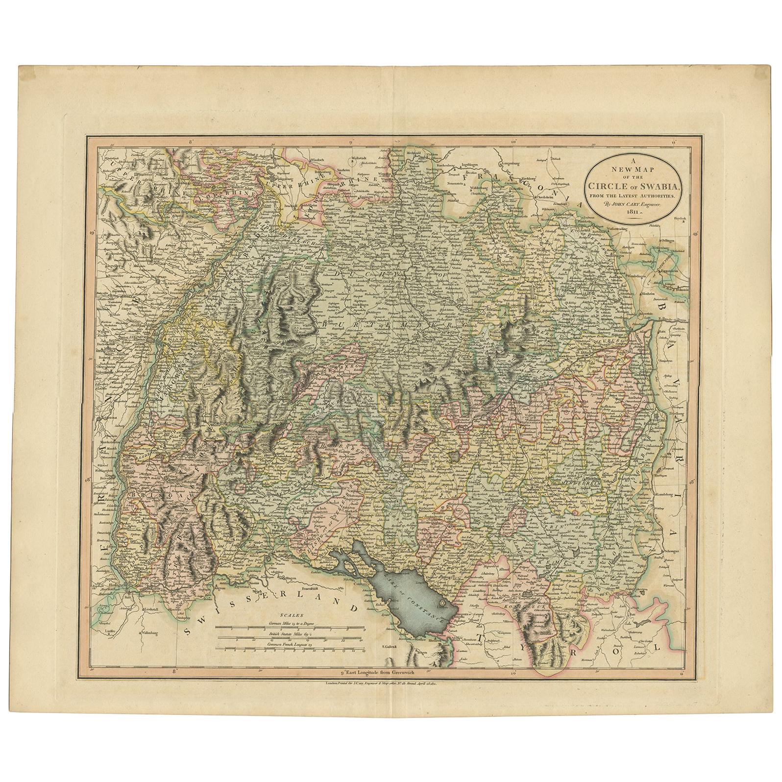
Antique Map of the Swabia Region of Germany by Cary,
1811
By John Cary
Located in Langweer, NL
Antique map titled 'A New Map of the Circle of Swabia'. Antique map of Swabia in Southwestern Germany. Covers from the Upper Rhine region south as far as Switzerland, Lake Constance ...
Category
Antique Early 19th Century Maps
Materials
Paper

Antique Map of Upper Saxony in Germany by Clouet, 1787
Located in Langweer, NL
Antique map titled 'Du Cercle de Haute Saxe'. Antique map of Upper Saxony, Germany. Originates from 'Geographie moderne avec une introduction' by J.B.L. Clouet.
Category
Antique Late 18th Century French Maps
Materials
Paper
You May Also Like
1839 Map of Karte Des "Russischen Reiches in Europa Und Asien" Ric.R0013
Located in Norton, MA
1839 map of Karte Des
"Russischen Reiches in Europa and Asien"
Ric.r013
Map of the European and Asian parts of Russian Empire. Karte der Russischen Reiches in Europa und Asien...
Category
Antique 19th Century Unknown Maps
Materials
Paper

Hand Colored 18th Century Homann Map of Austria Including Vienna and the Danube
By Johann Baptist Homann
Located in Alamo, CA
"Archiducatus Austriae inferioris" is a hand colored map of Austria created by Johann Baptist Homann (1663-1724) and published in Nuremberg, Germany in 1728 shortly after his death. ...
Category
Antique Early 18th Century German Maps
Materials
Paper

18th Century Hand-Colored Homann Map of Germany, Including Frankfurt and Berlin
By Johann Baptist Homann
Located in Alamo, CA
An 18th century hand-colored map entitled "Tabula Marchionatus Brandenburgici et Ducatus Pomeraniae quae sunt Pars Septentrionalis Circuli Saxoniae Superioris" by Johann Baptist Homa...
Category
Antique Early 18th Century German Maps
Materials
Paper

1853 Map of "Russia in Europe Including Poland" Ric.r016
Located in Norton, MA
Description
Russia in Europe incl. Poland by J Wyld c.1853
Hand coloured steel engraving
Dimension: Paper: 25 cm W x 33 cm H ; Sight: 22 cm W x 28 cm H
Condition: Good ...
Category
Antique 19th Century Unknown Maps
Materials
Paper

1790 Thomas Stackhouse Map, Entitled "Russia in Europe, " , Ric.a004
Located in Norton, MA
1790 Thomas Stackhouse map, entitled
"Russia in Europe"
Ric.a004
Stackhouse, Thomas
Russia in Europe [map]
London: T. Stackhouse, 1783. Map. Matted hand-colored copper engraving. Image size: 14.5 x 15.25 inches. Mat size: 22.75 x 23.75 inches. A beautiful example of this map of Eastern Europe...
Category
Antique 17th Century Unknown Maps
Materials
Paper

Map of Switzerland - Etching - 19th Century
Located in Roma, IT
This map of Netherlands is an etching realized in 19th century.
The state of preservation of the artwork is excellent. The signature "F.B." is engraved on the lower right. At the to...
Category
19th Century Figurative Prints
Materials
Etching

More Ways To Browse
Bavaria Antique
Antique Atlas Furniture
Antique Maps Indonesia
Map Of India
China Map
Victorian Furniture 1920
Antique Maps Amsterdam
Antique Maps Of Russia
19th Century Map Of Africa
Map Of Britain
Antique Oregon
Bali Wood
Railroad Furniture
Antique Malaysia
Blaeu Maps
Antique Topographic Maps
Antique Maps Of North America
Antique Maps Of Italy