Items Similar to Antique Map of the Black Sea and Crimea by Pierre Antoine Tardieu (1784-1869)


Want more images or videos?
Request additional images or videos from the seller
1 of 10
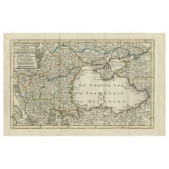
Antique Map of the Black Sea and Crimea by Pierre Antoine Tardieu (1784-1869)
$582.48
£433.54
€490
CA$807.85
A$869.72
CHF 465.75
MX$10,479.81
NOK 5,876.49
SEK 5,377.94
DKK 3,734.71
About the Item
This is an original antique map titled "Carte de la Mer Noire ou Kara Degniz," depicting the Black Sea region. This map, created by Pierre Antoine Tardieu, highlights the geographical and political features surrounding the Black Sea, including parts of modern-day Turkey, Romania, Bulgaria, Ukraine, Russia, and Georgia.
Map Details:
* Title: Carte de la Mer Noire ou Kara Degniz
* Creator: Pierre Antoine Tardieu (1784–1869)
* Publication Date: Early 19th century
* Dimensions: Approximately 34.5 x 43.5 cm (13.5 x 17.25 inches)
* Features: The map showcases the Black Sea with detailed coastlines and significant geographical features such as rivers, mountain ranges, and cities. It includes the Sea of Azov and part of the surrounding territories. The title cartouche is centrally located at the top of the map, and the outlines are hand-colored.
Around the year 1800, the region surrounding the Black Sea was a complex and dynamic area influenced by several powerful empires and characterized by a mix of cultures, languages, and religions. Here’s a detailed overview of the region during that period:
Political Landscape:
1. Ottoman Empire: Controlled much of the southern coastline, including present-day Turkey and parts of the Balkans. The Empire was still influential but facing decline, with power often delegated to local rulers.
2. Russian Empire: Rapidly expanding southward, Russia controlled the northern Black Sea coast and had recently annexed Crimea in 1783. Cities like Sevastopol and Odessa began to rise in prominence.
3. Crimean Khanate: Formerly a powerful vassal of the Ottoman Empire, it had been absorbed into the Russian Empire by the late 18th century, signaling a major power shift.
4. Habsburg Monarchy: While not directly bordering the Black Sea, Austria’s influence in the Balkans impacted the broader political dynamics in the region.
5. Moldavia and Wallachia: These Ottoman vassal states (modern Romania) served as strategic buffer zones between the Ottoman and Russian Empires.
Socio-Economic Conditions:
* Trade and Commerce: The Black Sea was a key commercial artery between Europe and Asia. Ports like Constantinople (Istanbul), Varna, and Trabzon were bustling with activity, especially in the grain trade.
* Agriculture and Resources: Fertile lands around the Danube and Crimea supported significant agricultural output, while fishing and mineral extraction played supporting economic roles.
* Cultural Diversity: The region hosted a mosaic of ethnicities—Turks, Greeks, Armenians, Slavs, Tatars, and others—and religious traditions, including Islam, Eastern Orthodoxy, and Judaism.
Conflicts and Changes:
* Russo-Turkish Wars: A series of conflicts in the late 18th century reshaped territorial control. The Treaty of Jassy (1792) confirmed Russian dominance over the northern coast and parts of the Caucasus.
* Decline of the Ottoman Empire: Internal challenges and nationalist uprisings marked a period of stagnation, despite efforts at reform and modernization.
* Napoleonic Wars: While indirect, the Napoleonic Wars affected alliances and political balance, influencing developments around the Black Sea.
Summary:
By 1800, the Black Sea region was a crossroads of empires, religions, and cultures, marked by shifting power, thriving trade, and enduring strategic importance. This antique map captures the historical geography of this pivotal area at a transformative time.
Condition Overview:
1. Paper Quality: Mild yellowing typical of antique paper, but structurally sound.
2. Edges and Corners: Slight wear and minor tears near the fold, but no major losses.
3. Center Fold: Original fold line intact and stable, with no critical damage.
4. Color and Print Quality: Hand-coloring remains vivid; print is sharp and clear.
5. Staining and Spots: Minor staining at edges and along fold, not affecting the map's legibility or visual impact.
Historical and Artistic Value:
Pierre Antoine Tardieu was a respected French engraver and cartographer whose finely detailed steel engravings offered clarity and precision superior to earlier copperplate maps. His work remains highly collectible and is valued both for its aesthetic qualities and historical documentation.
- Dimensions:Height: 16.23 in (41.2 cm)Width: 21.26 in (54 cm)Depth: 0.01 in (0.2 mm)
- Materials and Techniques:Paper,Engraved
- Place of Origin:
- Period:
- Date of Manufacture:1802
- Condition:Good condition with minor age-related wear. Hand-colored boundaries are well-preserved, enhancing the clarity of regions and features. Fold lines and edge wear are visible. Study the images carefully.
- Seller Location:Langweer, NL
- Reference Number:Seller: BG-13769-291stDibs: LU3054340565322
About the Seller
5.0
Recognized Seller
These prestigious sellers are industry leaders and represent the highest echelon for item quality and design.
Platinum Seller
Premium sellers with a 4.7+ rating and 24-hour response times
Established in 2009
1stDibs seller since 2017
2,828 sales on 1stDibs
Typical response time: 1 hour
- ShippingRetrieving quote...Shipping from: Langweer, Netherlands
- Return Policy
More From This Seller
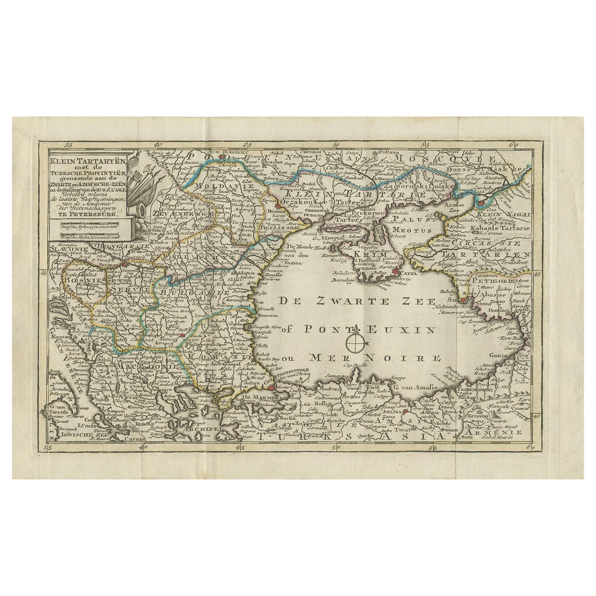
View AllAntique Map of the Black Sea and Surroundings by Keizer
de Lat, 1788
Located in Langweer, NL
Antique map titled 'Klein Tartaryën met de Turksche Provintiën (..)'. Uncommon original antique map of the Black Sea and surroundings. This map originates from 'Nieuwe Natuur- Geschi...
Category
Antique Late 18th Century Maps
Materials
Paper
$332 Sale Price
20% Off
Antique Map of the Persian Gulf and Caspian Sea Region by R. Bonne, 1780
Located in Langweer, NL
Antique print titled 'Carte de la Perse, de la Georgie, et de la Tartarie Independante'. Shows the region from the Persian Gulf and Caspian Sea in the wes...
Category
Antique Late 18th Century French Maps
Materials
Paper

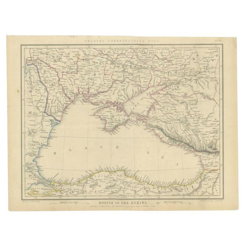
Antique Map of the Black Sea and Surroundings by Sharpe, 1849
Located in Langweer, NL
Antique map titled 'Russia on the Euxine'. Old map of the Black Sea and the surrounding (Russia). This map originates from 'Sharpe's Corresponding Atlas (..)' by J. Sharpe. Artists and Engravers: Published by Chapman and Hall...
Category
Antique 19th Century Maps
Materials
Paper

$90 Sale Price
20% Off
Antique Map of the Caspian Sea and Surroundings by Bellin, 1764
Located in Langweer, NL
Antique map titled 'Carte de la Mer Caspienne et ses Environs'. Old map depicting the region of the Caspian Sea. This map originates from 'Le Petit Atlas M...
Category
Antique 18th Century Maps
Materials
Paper

$177 Sale Price
20% Off
Black Sea
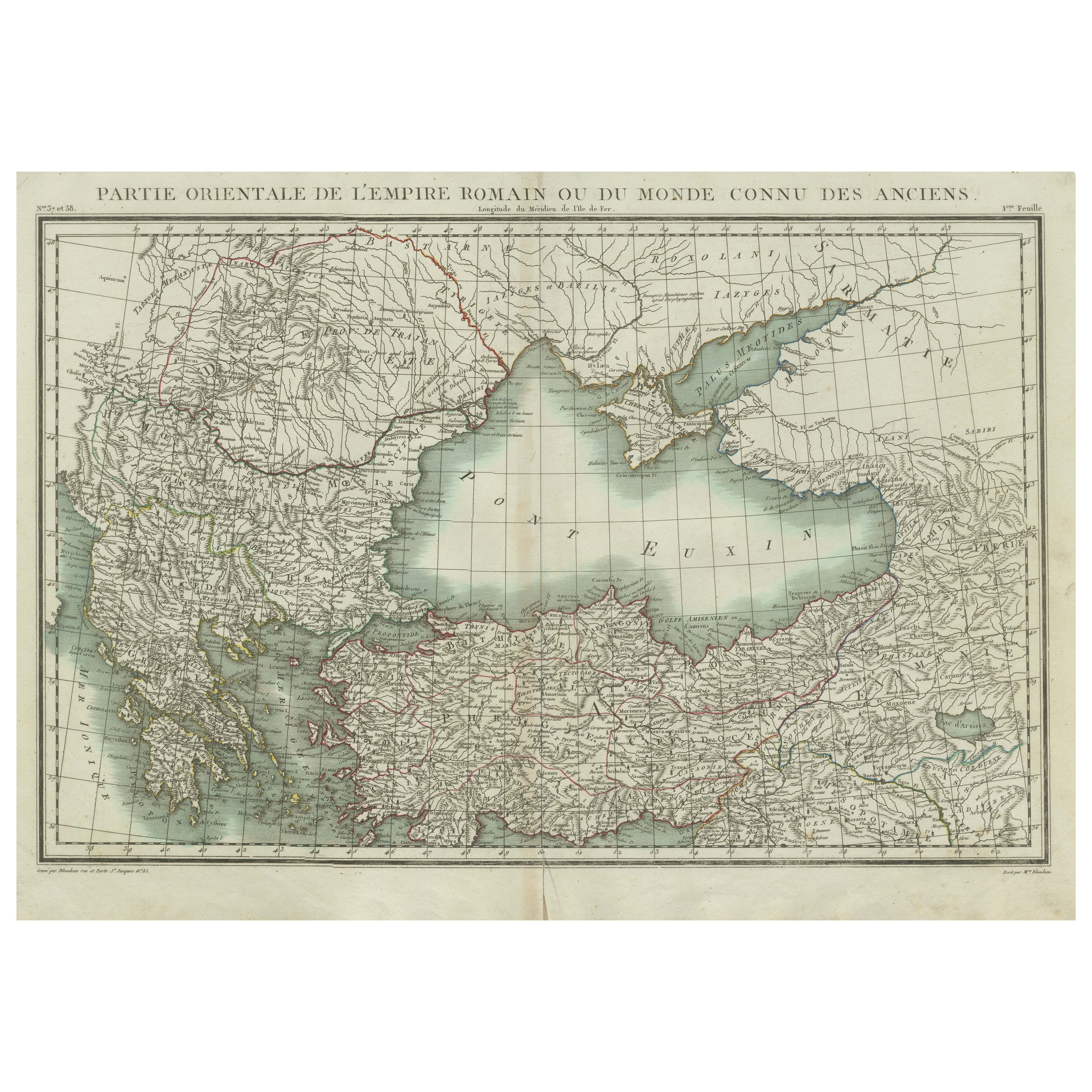
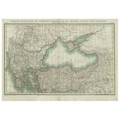
Eastern Mediterranean Map: Eastern Roman Empire, Tardieu Atlas, 1802
Located in Langweer, NL
Antique Map with Title: "Partie Orientale de l'Empire Romain ou du Monde connu des Anciens"
Publication Details:
- **Atlas Title:** Nouvel Atlas Universel de Géographie Ancienne e...
Category
Antique Early 1800s Maps
Materials
Paper
$494 Sale Price
20% Off
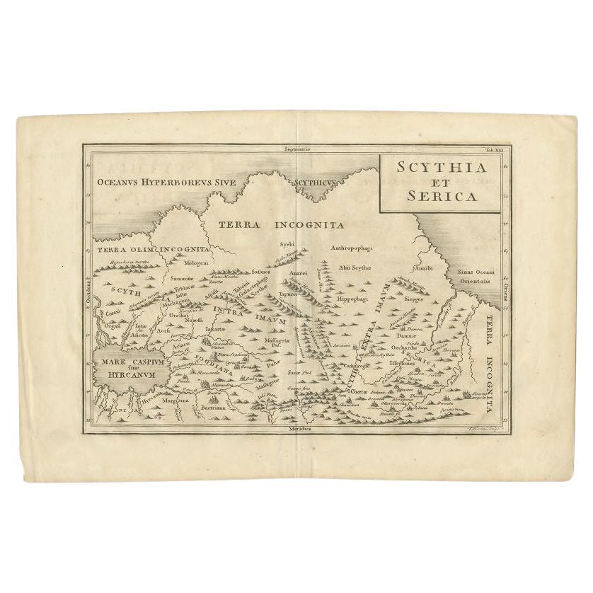
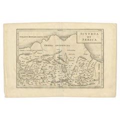
Antique Map of the Region Between the Caspian and the Sea of China by Toms, 1799
Located in Langweer, NL
Antique map titled 'Scythia et Serica'. Old map of the region between the Caspian and the Sea of China. Originates from 'Geographia Antiqua (..)'.
Artists and Engravers: Engraved ...
Category
Antique 18th Century Maps
Materials
Paper
You May Also Like
Hand-Colored 18th Century Homann Map of the Black Sea, Turkey and Asia Minor
By Johann Baptist Homann
Located in Alamo, CA
An attractive original early 18th century hand-colored map of the Black Sea and Turkey entitled "Carte de L'Asie Minevre ou de la Natolie et du Pont Evxin Tiree des Voyages et des Ob...
Category
Antique Early 18th Century German Maps
Materials
Paper

1814 Map of "Russian Empire" Ric.r032
Located in Norton, MA
1814 Map of
"Russian Empire"
Ric.r032
Russian Empire. Description: This is an 1814 John Thomson map of the Russian Empire. The map depicts the region from the Baltic Sea, Prussia, and Sweden to the Aleutian Islands and from the Arctic Ocean to the Yellow River. Highly detailed, myriad cities, towns, and villages are labeled throughout, including St. Petersburg, Moscow, Minsk, Kiev, and Kharkov. Rivers and mountain ranges are also identified, as are islands and numerous locations along the coastlines. It is important to note that the long-disputed sea between Korea and Japan is identified as the 'Sea of Japan.
Historical Context:
In 1815, Tsarist Russia emerged from the Napoleonic Wars economically insolvent and politically fearful of the Revolutionary fervor that had just swept through Europe. In order to shore up Russia's economic position, the Tsars began an aggressive series of expansions into the Caucuses and Central Asia that would vastly increase the landmass of the Russian Empire.
Publication History
Thomson maps are known for their stunning color, awe inspiring size, and magnificent detail. Thomson's work, including this map, represents some of the finest cartographic art...
Category
Antique 19th Century Unknown Maps
Materials
Paper

1790 Thomas Stackhouse Map, Entitled "Russia in Europe, " , Ric.a004
Located in Norton, MA
1790 Thomas Stackhouse map, entitled
"Russia in Europe"
Ric.a004
Stackhouse, Thomas
Russia in Europe [map]
London: T. Stackhouse, 1783. Map. Matted hand-colored copper engraving. Image size: 14.5 x 15.25 inches. Mat size: 22.75 x 23.75 inches. A beautiful example of this map of Eastern Europe...
Category
Antique 17th Century Unknown Maps
Materials
Paper

Original Antique Map of Hungary, Arrowsmith, 1820
Located in St Annes, Lancashire
Great map of Hungary
Drawn under the direction of Arrowsmith.
Copper-plate engraving.
Published by Longman, Hurst, Rees, Orme and Brown, 1820
Unframed.
Category
Antique 1820s English Maps
Materials
Paper

Antique French Map of Asia Including China Indoneseia India, 1783
Located in Amsterdam, Noord Holland
Very nice map of Asia. 1783 Dedie au Roy.
Additional information:
Country of Manufacturing: Europe
Period: 18th century Qing (1661 - 1912)
Condition: Overall Condition B (Good Used)...
Category
Antique 18th Century European Maps
Materials
Paper

$486 Sale Price
40% Off
Original Antique Map of Ancient Greece, Achaia, Corinth, 1786
Located in St Annes, Lancashire
Great map of Ancient Greece. Showing the region of Thessaly, including Mount Olympus
Drawn by J.D. Barbie Du Bocage
Copper plate engraving by P.F Tardieu
Original hand color...
Category
Antique 1780s French Other Maps
Materials
Paper

More Ways To Browse
Napoleonic Wars
Istanbul Antique
1960s Glass Top Coffee Table
Black Glass Coffee Tables
Mid Century Wrought Iron Chairs
Earth Toned Rug
Black Marble Table Vintage
Goblets
Mid Century Modern Yellow Chair
Paulin Pierre
Used Pianos Pianos
18th Century Engravings
Antique Carved Wood Chair
Black Scandinavian Modern Dining Chairs
Dutch Mid Century Modern Table
Gold Modern Coffee Table
Iconic Modern Furniture
Japanese Metal