Items Similar to Antique 1848 Map of the Black Sea by Justus Perthes, 19th Century


Want more images or videos?
Request additional images or videos from the seller
1 of 9
Antique 1848 Map of the Black Sea by Justus Perthes, 19th Century
On Hold
$117.47
On Hold
£87.60
On Hold
€99
On Hold
CA$163.51
On Hold
A$175.49
On Hold
CHF 94.07
On Hold
MX$2,111.89
On Hold
NOK 1,186.05
On Hold
SEK 1,081.51
On Hold
DKK 754.32
About the Item
Antique map titled 'Pontus Euxinus'. Old map of the Black Sea and surroundings originating from 'Orbis Terrarum Antiquus in usum Scholarum'. Artists and Engravers: Published by Justus Perthes, 1848.
Artist: Published by Justus Perthes, 1848.
Condition: Good, general age-related toning. Minor defects, please study image carefully.
Date: 1848
Antique prints have long been appreciated for both their aesthetic and investment value. They were the product of engraved, etched or lithographed plates. These plates were handmade out of wood or metal, which required an incredible level of skill, patience and craftsmanship. Whether you have a house with Victorian furniture or more contemporary decor an old engraving can enhance your living space. We offer a wide range of authentic antique prints for any budget.
- Dimensions:Height: 9.77 in (24.8 cm)Width: 12.52 in (31.8 cm)Depth: 0.01 in (0.2 mm)
- Materials and Techniques:
- Period:
- Date of Manufacture:1848
- Condition:Condition: Good, general age-related toning. Minor defects, please study image carefully.
- Seller Location:Langweer, NL
- Reference Number:Seller: BG-11845-111stDibs: LU3054327770662
About the Seller
5.0
Recognized Seller
These prestigious sellers are industry leaders and represent the highest echelon for item quality and design.
Platinum Seller
Premium sellers with a 4.7+ rating and 24-hour response times
Established in 2009
1stDibs seller since 2017
2,830 sales on 1stDibs
Typical response time: 1 hour
- ShippingRetrieving quote...Shipping from: Langweer, Netherlands
- Return Policy
More From This Seller
View AllAntique Map of the Middle East by Perthes, 1848
Located in Langweer, NL
Antique map titled 'Terra inter Euphratem et Indum Antiqua'. Old map of the Middle East originating from 'Orbis Terrarum Antiquus in usum Schola...
Category
Antique 19th Century Maps
Materials
Paper

Antique Map of Northern Africa by Perthes, 1848
Located in Langweer, NL
Antique map titled 'Africa Propria (..)'. Old map of North Africa and the region of Babylon originating from 'Orbis Terrarum Antiquus in usum Scholarum'. Artists and Engravers: Publi...
Category
Antique 19th Century Maps
Materials
Paper

$93 Sale Price
20% Off
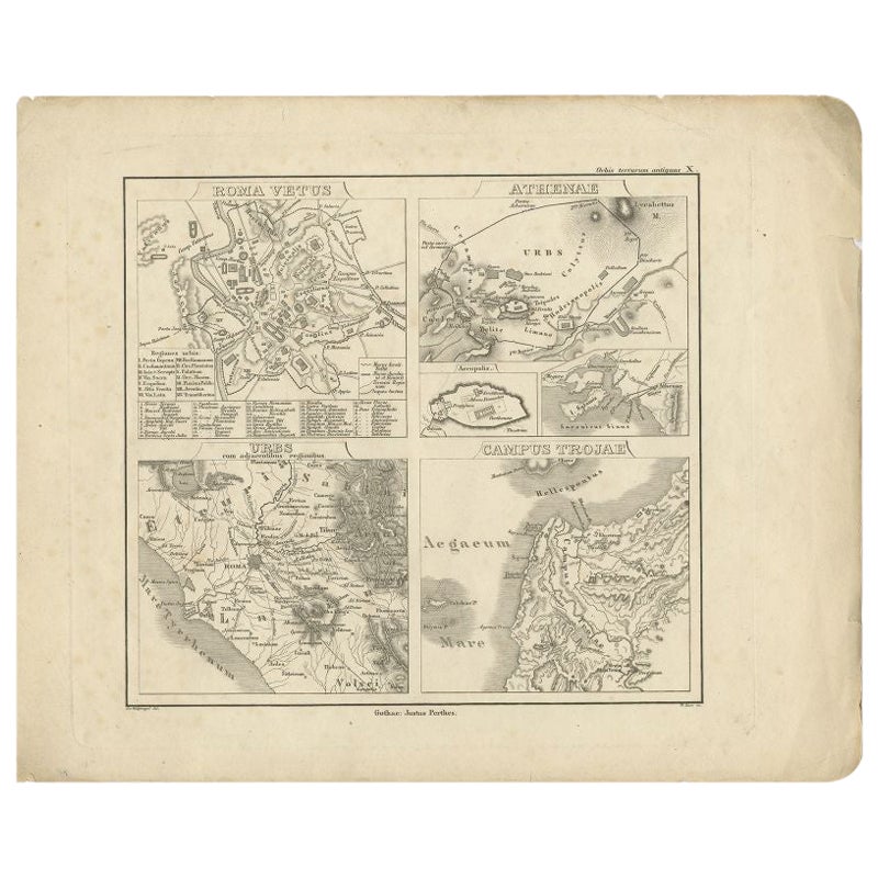
Antique Map of Rome and Athens by Perthes, 1848
Located in Langweer, NL
Antique map titled 'Roma Vetus, Athenae, Urbs, Campus Trojae'. Old map of Rome, Athens and surroundings originating from 'Orbis Terrarum Antiquus in usum S...
Category
Antique 19th Century Maps
Materials
Paper
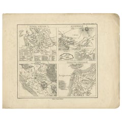
$93 Sale Price
20% Off
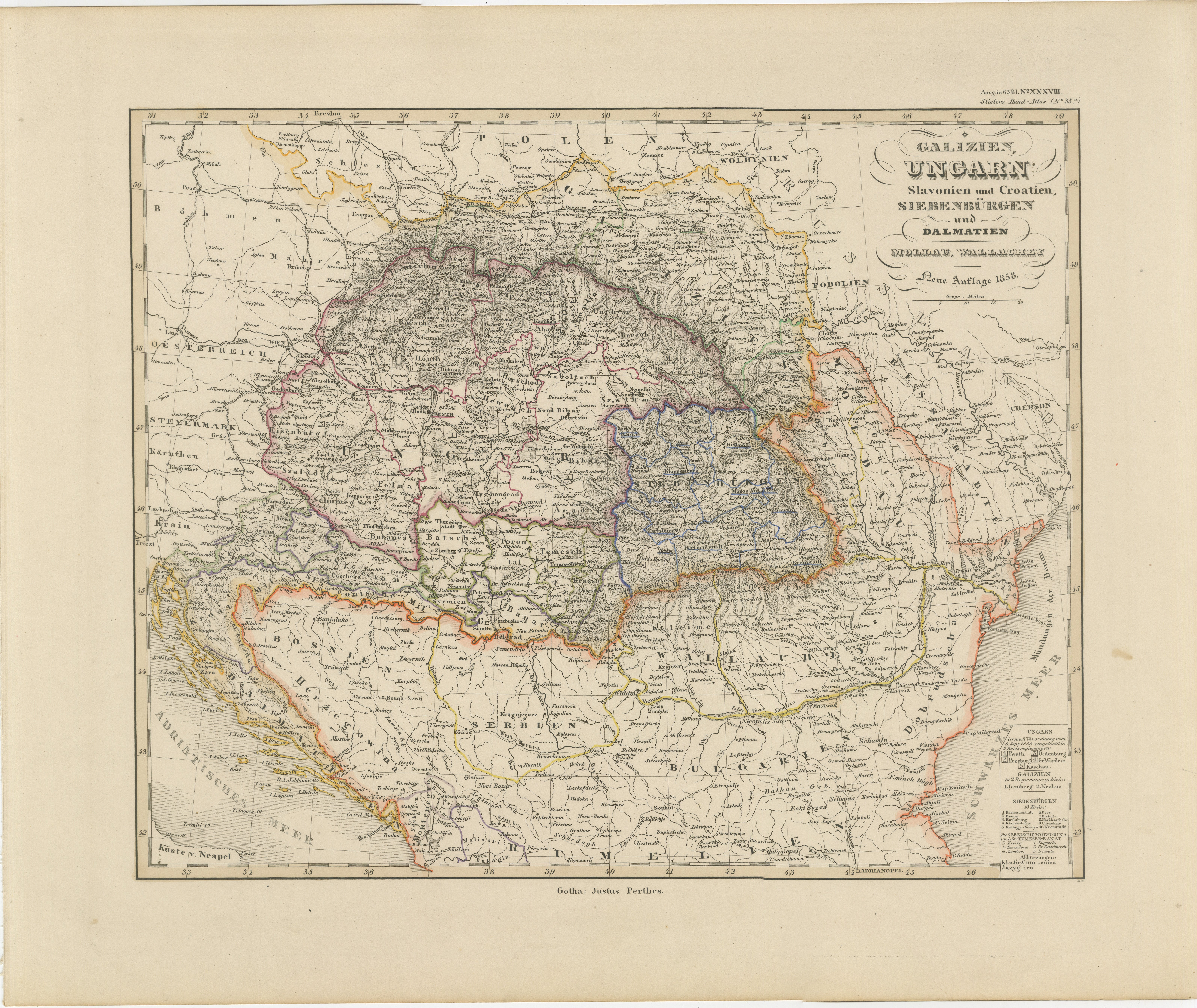
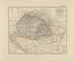
1858 Map of Hungary, Galicia
the Balkans – Justus Perthes Engraving
Located in Langweer, NL
1858 Map of Hungary, Galicia & the Balkans – Justus Perthes Engraving
Antique map titled "Galizien, Ungarn, Slavonien und Croatien, Siebenbürgen und Dalmatien," published by Justus ...
Category
Antique Mid-19th Century German Maps
Materials
Paper
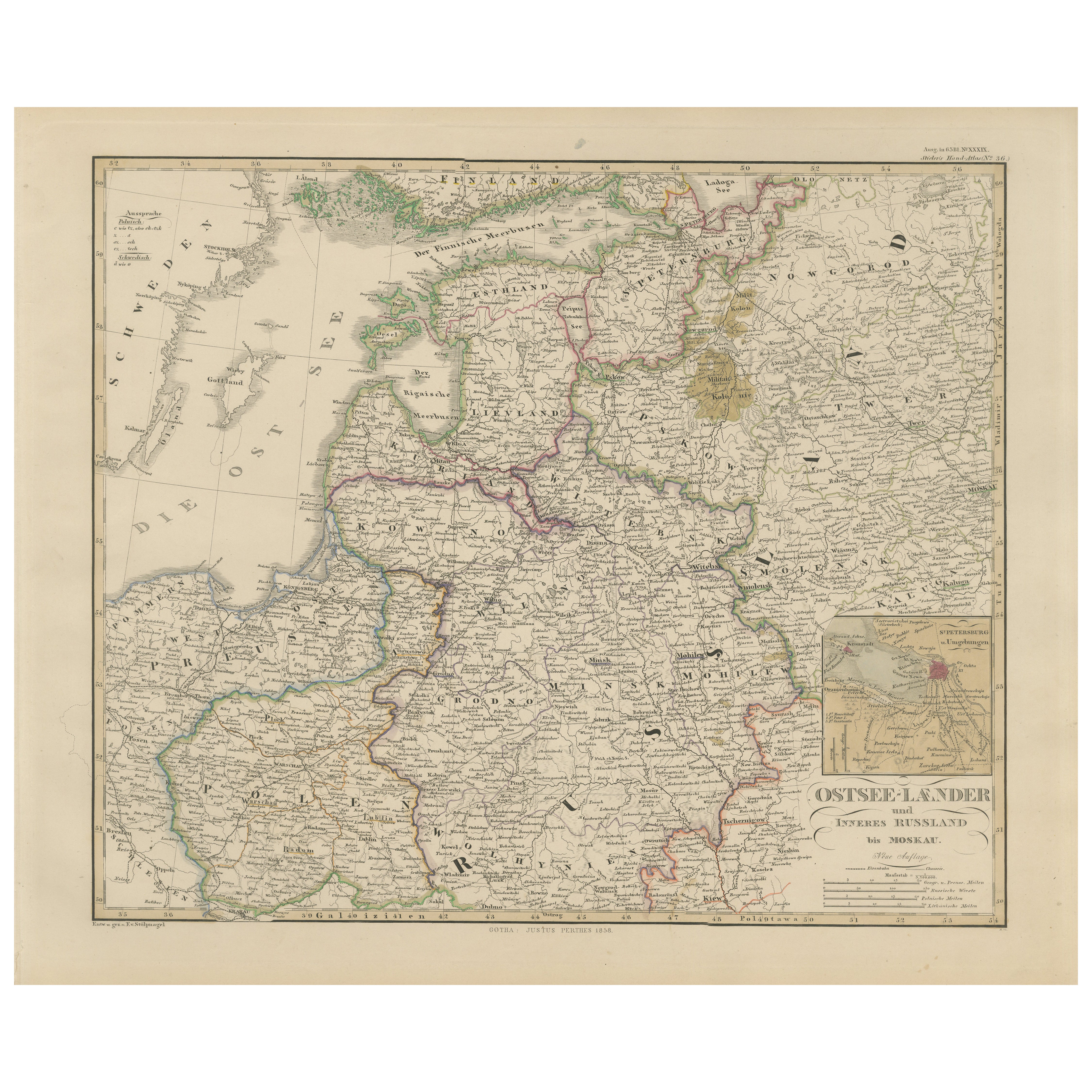
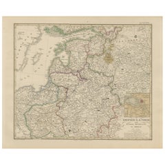
1858 Map of the Baltic States
Inner Russia to Moscow – Justus Perthes
Located in Langweer, NL
1858 Map of the Baltic States & Inner Russia to Moscow – Justus Perthes
Description:
Antique map titled "Ostsee-Länder und das Innere Russland bis Moskau," published by Justus Perth...
Category
Antique Mid-19th Century German Maps
Materials
Paper
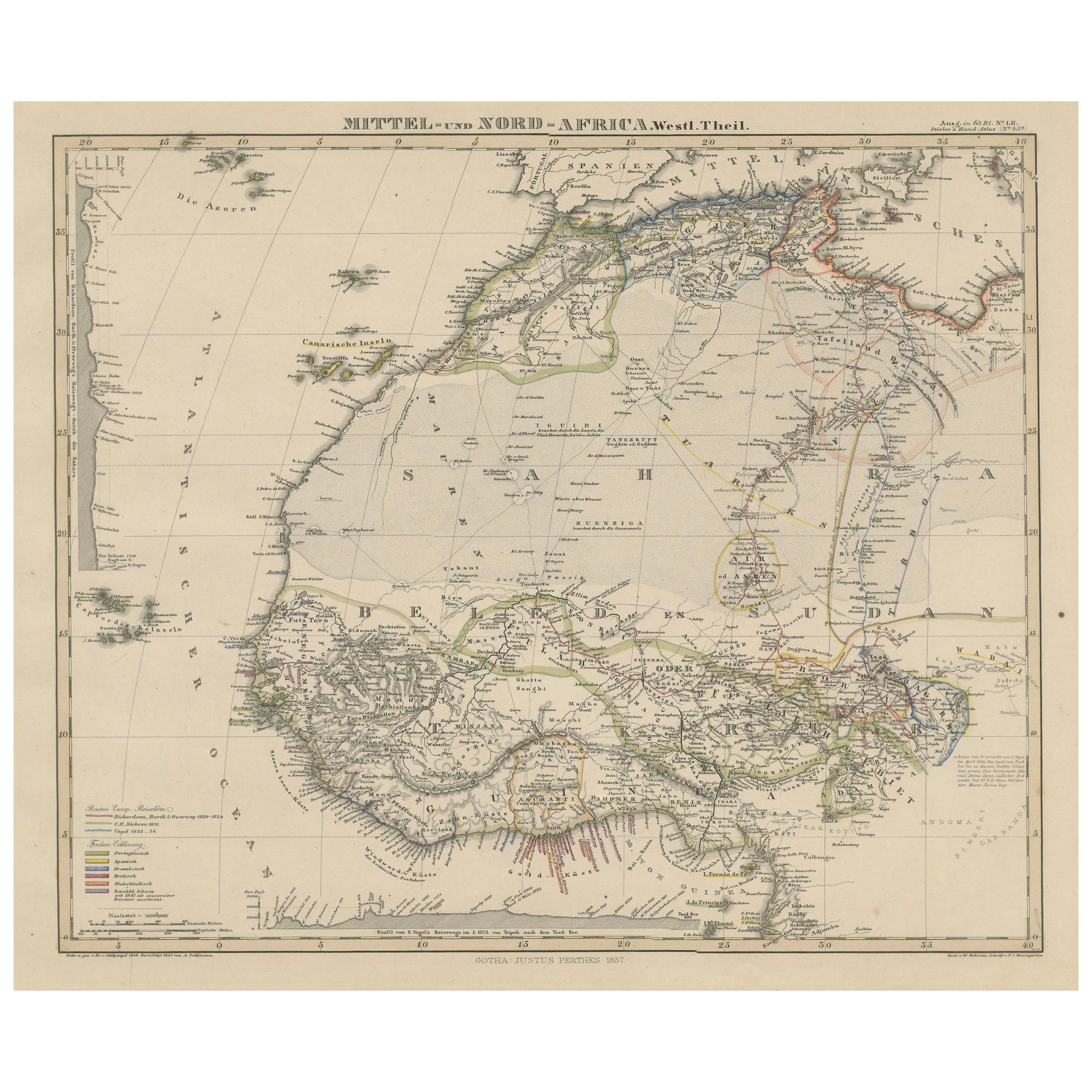
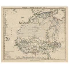
Antique Map of West and Central Africa – Stieler Atlas, Justus Perthes 1857
Located in Langweer, NL
Antique Map of West and Central Africa – Stieler Atlas, Justus Perthes 1857
This finely engraved map titled "Mittel- und Nord-Africa. Westl. Theil." was published in 1857 by Justus ...
Category
Antique Mid-19th Century German Maps
Materials
Paper
You May Also Like
Large 19th Century Map of France
Located in Pease pottage, West Sussex
Large 19th Century Map of France.
Remarkable condition, with a pleasing age worn patina.
Recently framed.
France Circa 1874.
Category
Antique Late 19th Century French Maps
Materials
Linen, Paper

Framed Mid-19th Century Wall Map of Long Island, the Hamptons
Located in Sag Harbor, NY
A Framed museum quality find. This large wall map dates to the mid-1800s. Detailed inset maps of, Sag Harbor, East Hampton, Amagansett, Shelter Island and most villages in Long Island. It also has agriculture stats for 1855. Detailed prints of homes on Scuttle Hole in Bridgehampton as well as several other detailed prints. Lists of businesses, distance tables and railroad schedules and stops. The total amount of detailed information about Suffolk County Long Island is staggering. A unique rare New York map...
Category
Antique Mid-19th Century American Maps
Materials
Linen, Paper

$7,100 Sale Price
20% Off
19th Century Reprint of 16th Century Harbor Map of Copenhagen
Located in Haddonfield, NJ
This reprint of 1587 antique map of Copenhagen, Denmark retains its original mid-century mat and has been recently reframed in classic wood frame. The muted sepia colored map is a wo...
Category
Antique 1880s Danish Baroque Maps
Materials
Wood, Paper

Hand-Colored 18th Century Homann Map of the Black Sea, Turkey and Asia Minor
By Johann Baptist Homann
Located in Alamo, CA
An attractive original early 18th century hand-colored map of the Black Sea and Turkey entitled "Carte de L'Asie Minevre ou de la Natolie et du Pont Evxin Tiree des Voyages et des Ob...
Category
Antique Early 18th Century German Maps
Materials
Paper

19th Century Lithograph Map of Lower Manhattan, New York
Located in Haddonfield, NJ
1859 hand colored map of Lower Manhattan or New Amsterdam by George H. Moore.
Category
Antique 19th Century English Folk Art Maps
Materials
Paper

$620 Sale Price
20% Off
America "Amérique Septentrionale": A 19th Century French Map by Delamarche
By Maison Delamarche 1
Located in Alamo, CA
This framed mid 19th century map of North America entitled "Amérique Septentrionale" by Felix Delamarche was published in Paris in 1854 by Quay de l'Horloge du Palais, avec les Carte...
Category
Antique Mid-19th Century American Other Maps
Materials
Paper

More Ways To Browse
Antique Maps Singapore
Antique Planisphere
Map Of Palestine
R Johnston
Santa Cruz Island
Shetland Map
Antique Alabama Map
Antique Framed Map Engravings
Antique Furniture Cheshire
Antique Great Lakes Map
Antique Map Of Michigan
Antique Map Of Turkish Empire
Antique Map Of Yorkshire
Bali Map
Bermuda Map
British Empire Map
Caucasus Map
Framed London Map