Items Similar to Antique Map of Bohemia, Dutch, Framed Cartography, Johannes Janssonius, C.1630

Want more images or videos?
Request additional images or videos from the seller
1 of 12
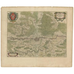
Antique Map of Bohemia, Dutch, Framed Cartography, Johannes Janssonius, C.1630
$1,815.81
£1,325
€1,558.06
CA$2,518.35
A$2,711.23
CHF 1,451.92
MX$32,669.39
NOK 18,319.18
SEK 16,765.01
DKK 11,642.44
About the Item
This is an antique map of Bohemia. A Dutch, framed atlas engraving of modern day Germany, Austria and the Czech Republic by Johannes Janssonius, dating to the 17th century and later, circa 1630.
Full Title - Bohemia in Suas Partes Geographice Dis Tincta
Fascinating cartography reproduction of Bohemia - perfect for display
Displaying a desirable aged patina with a lightly time-worn appearance to the map
Historically appealing cartography, tastefully set within a later glazed frame
Compiled by the esteemed cartographer Johannes Janssonius (1588 - 1664)
Title presented in Latin, reading as 'Bohemia is geographically divided into its parts'
Gently aged hand colouring accentuates the map borders
Informative key presents points of interest as featured within the map
Dressed to the rear with hanging wire for ease of mounting
This is a charming antique map of Bohemia, with appealing cartographic interest. Ideal for collectors of historic European interest. Delivered ready to display.
Dimensions:
Max Width: 70cm (27.5'')
Max Depth: 3cm (1.25'')
Max Height: 61.5cm (24.25'')
Map Width: 46.5cm (18.25'')
Map Height: 40.5cm (16'')
- Dimensions:Height: 24.22 in (61.5 cm)Width: 27.56 in (70 cm)Depth: 1.19 in (3 cm)
- Style:Baroque (Of the Period)
- Materials and Techniques:
- Place of Origin:
- Period:
- Date of Manufacture:Circa 1630
- Condition:Wear consistent with age and use. Presented in original, patinated antique condition.
- Seller Location:Hele, Devon, GB
- Reference Number:Seller: 257331stDibs: LU2645348233722
About the Seller
5.0
Platinum Seller
Premium sellers with a 4.7+ rating and 24-hour response times
Established in 2005
1stDibs seller since 2017
1,090 sales on 1stDibs
Typical response time: <1 hour
- ShippingRetrieving quote...Shipping from: Hele, Devon, United Kingdom
- Return Policy
More From This Seller
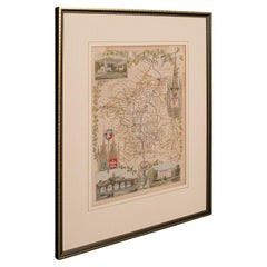
View AllAntique County Map of Cheshire, Dutch, Framed, Cartography, Janssonius, C.1660
Located in Hele, Devon, GB
This is an antique county map of Cheshire. A Dutch, framed atlas engraving by Johannes Janssonius, dating to the 17th century and later.
A treat for the collector or county native,...
Category
Antique Mid-17th Century Dutch Charles II Maps
Materials
Glass, Wood, Paper

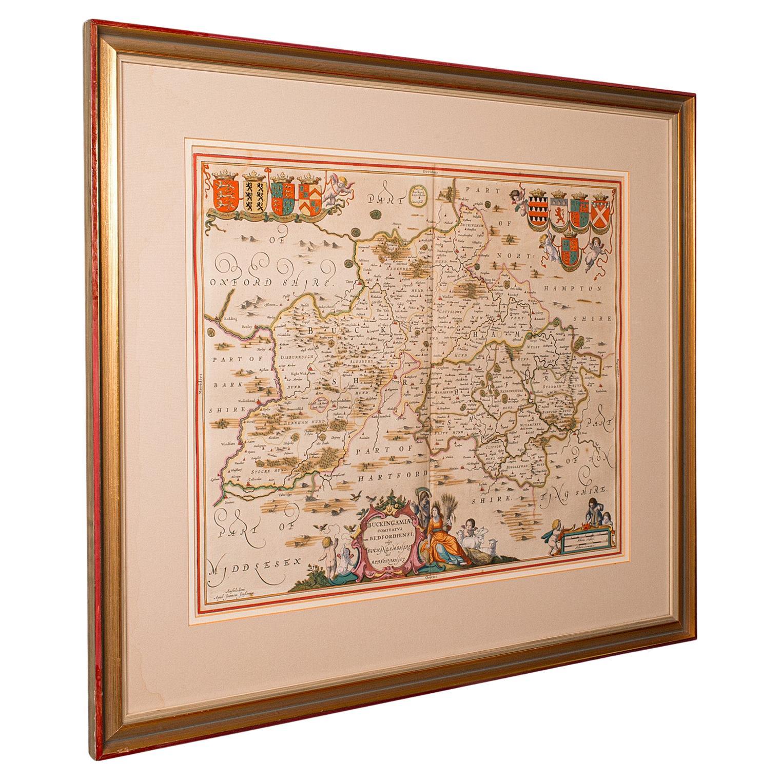
Antique County Map, Buckinghamshire, Bedfordshire, Dutch, Framed, Janssonius
Located in Hele, Devon, GB
This is an antique county map of Buckinghamshire and Bedfordshire. A Dutch, framed atlas engraving by Johannes Janssonius, dating to the 17th century and later.
A treat for the col...
Category
Antique Mid-17th Century Dutch Maps
Materials
Paper

Antique Lithography Map, Bedfordshire, English, Framed Engraving, Cartography
Located in Hele, Devon, GB
This is an antique lithography map of Bedfordshire. An English, framed atlas engraving of cartographic interest, dating to the mid 19th century and...
Category
Antique Mid-19th Century British Victorian Maps
Materials
Wood

Antique Lithography Map, Northumberland, English, Framed, Engraving, Cartography
Located in Hele, Devon, GB
This is an antique lithography map of Northumberland. An English, framed atlas engraving of cartographic interest, dating to the mid 19th century a...
Category
Antique Mid-19th Century British Victorian Maps
Materials
Wood

Antique Lithography Map, Worcestershire, English, Framed Engraving, Cartography
Located in Hele, Devon, GB
This is an antique lithography map of Worcestershire. An English, framed atlas engraving of cartographic interest, dating to the early 19th centur...
Category
Antique Early 19th Century British Regency Maps
Materials
Wood
Antique Lithography Map, Northamptonshire, English, Framed Cartography, C.1860
Located in Hele, Devon, GB
This is an antique lithography map of Northamptonshire. An English, framed atlas engraving of cartographic interest, dating to the mid 19th century...
Category
Antique Mid-19th Century British Victorian Maps
Materials
Wood

You May Also Like
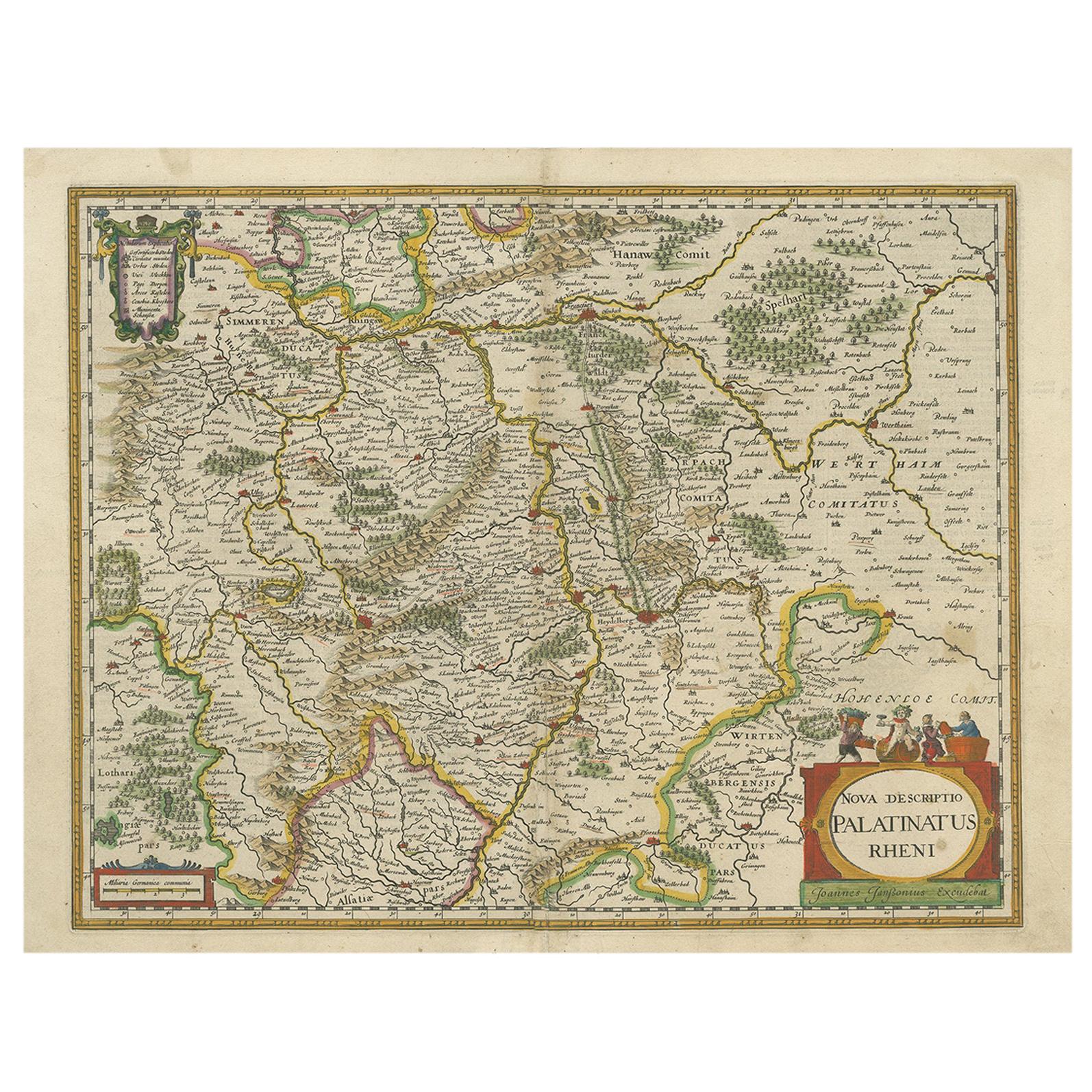
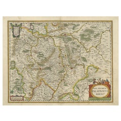
Antique Map of the Rhine-Palatinate by Janssonius, circa 1630
Located in Langweer, NL
Antique map titled 'Nova Descriptio Palatinatus Rheni'. Detailed map of the Rhine-Palatinate, a state of Germany located in the west of the country. The map tracks the course of the ...
Category
Antique Mid-17th Century Maps
Materials
Paper
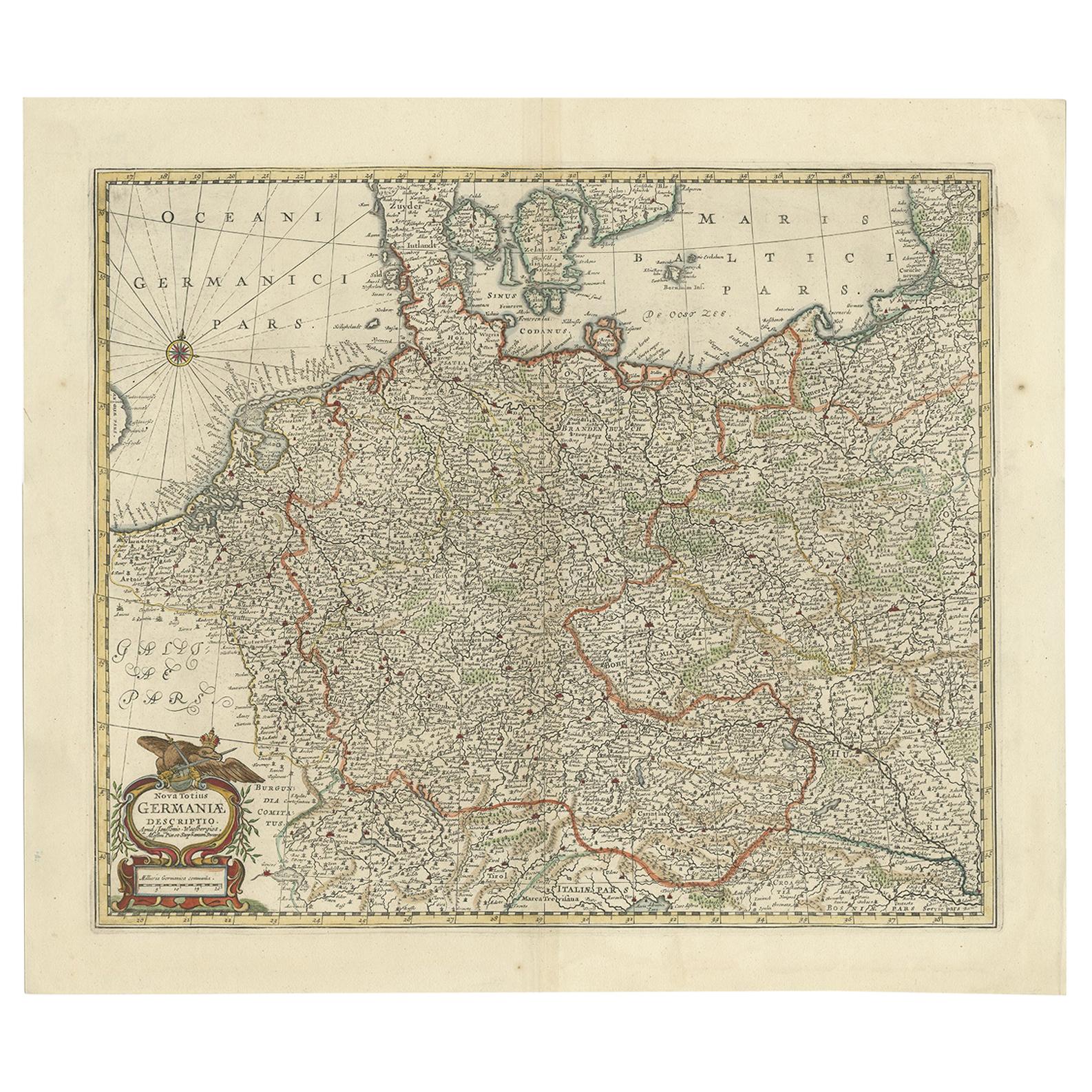
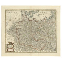
Antique Map of the German Empire, Johannes Janssonius van Waesbergen, circa 1670
Located in Langweer, NL
Antique map titled 'Nova Totius Germaniae Descriptio'. Uncommon map of the German Empire including the Netherlands, Germany, Switzerland, Austria, Bohemia,...
Category
Antique Late 17th Century Maps
Materials
Paper
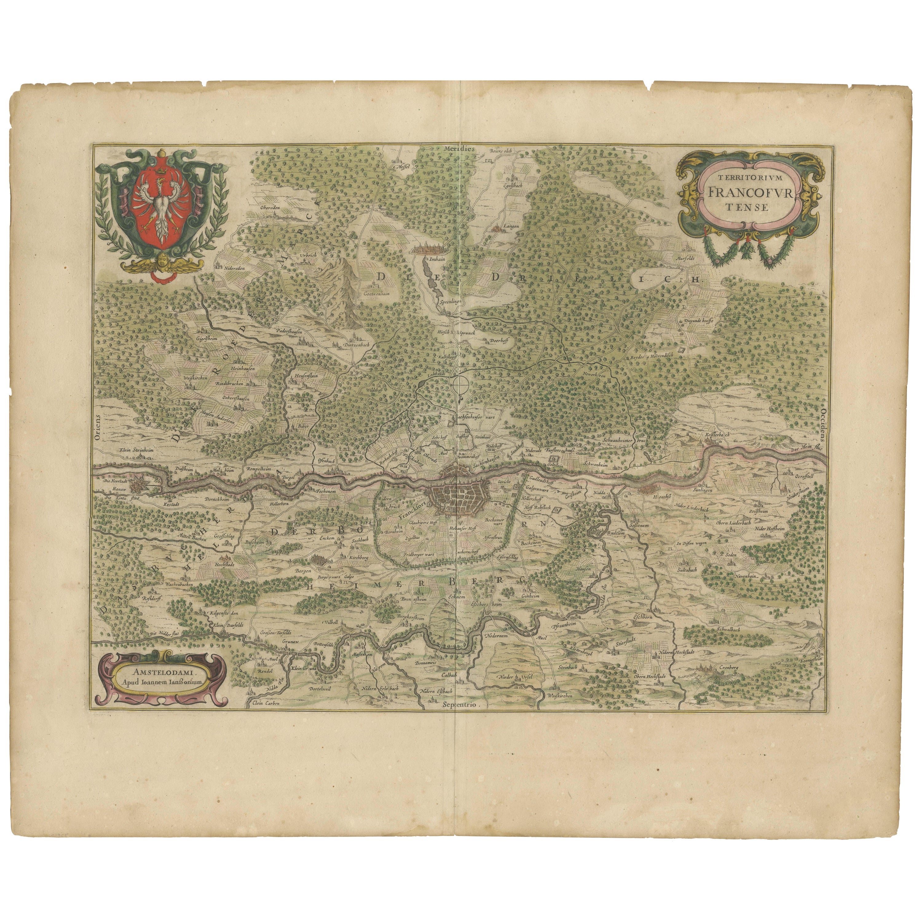
Antique Map of the Frankfurt Region by Johannes Janssonius, Hand-Colored, C.1650
Located in Langweer, NL
Antique Map of the Frankfurt Region by Johannes Janssonius circa 1650 Hand-Colored
This rare and beautifully detailed antique map titled Territorium Francofurtense depicts the reg...
Category
Antique 1650s Maps
Materials
Paper
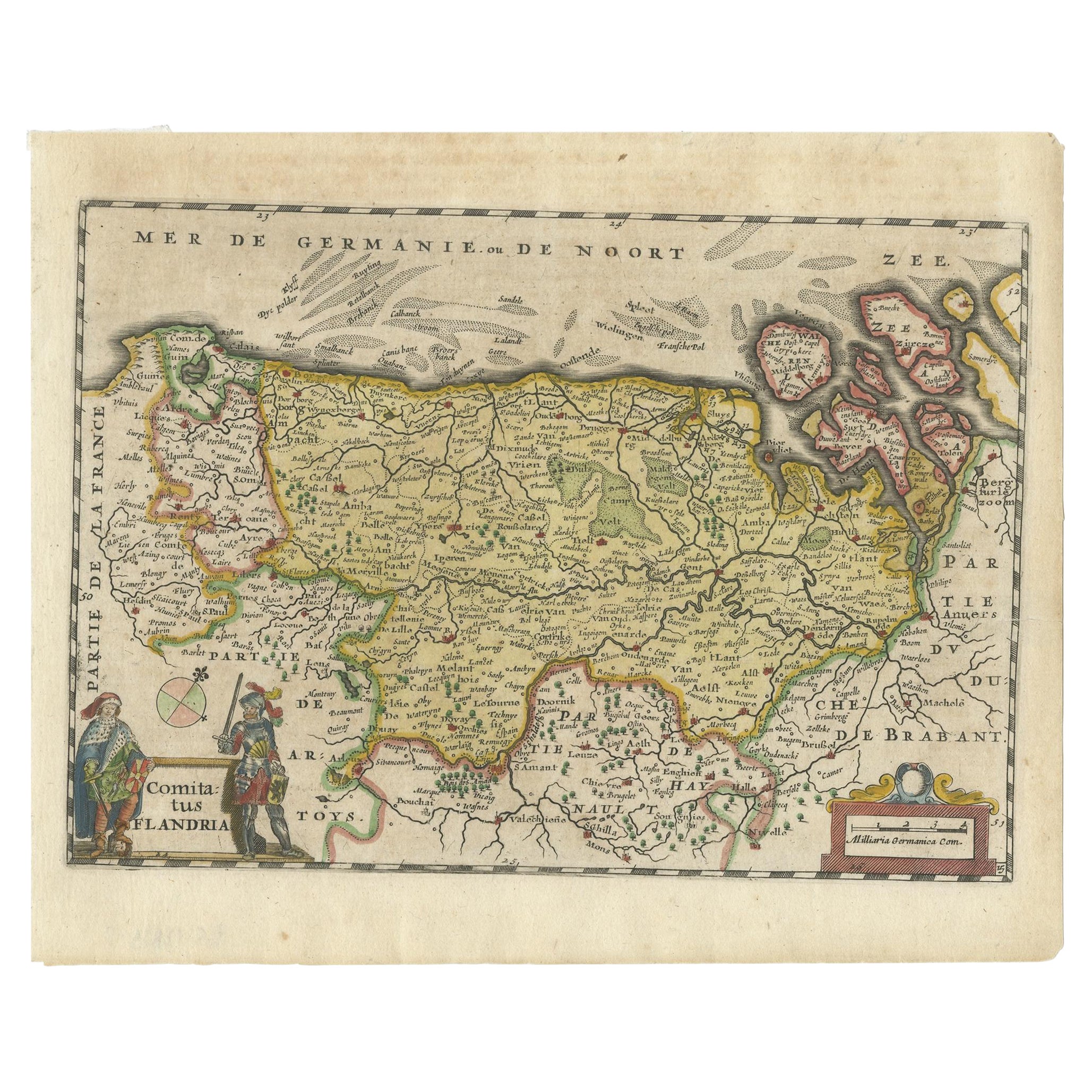
Antique Map of Flanders, Belgium, 1630
Located in Langweer, NL
Antique map titled 'Comitatus Flandria'. Original antique map of Flanders, Belgium. This map originates from 'Vyerige Colom verthonende de 17 Nederlandsche Provintien' published 1630...
Category
Antique 17th Century Maps
Materials
Paper
Antique Map by Janssonius of the Dutch Province of Overijsel, ca.1650
Located in Langweer, NL
Very good, given the age. Center fold as issued with wide margins. Sharp print with beautiful old-fashioned colouring, carbon copy on verso. Paper in the margins somewhat browned.
Category
Antique 1650s Maps
Materials
Paper

$418 Sale Price
20% Off
Antique Map of Beauce by Janssonius, 1657
By Johannes Janssonius
Located in Langweer, NL
Antique map 'Belsia vulgo la Beausse'. Decorative map of the region of Beauce, a natural region in northern France, located between the Seine and Loire rivers. This map originates fr...
Category
Antique Mid-17th Century Maps
Materials
Paper
