Items Similar to Antique Map of Brabant
The Netherlands
by N. Visscher, circa 1670
Want more images or videos?
Request additional images or videos from the seller
1 of 5
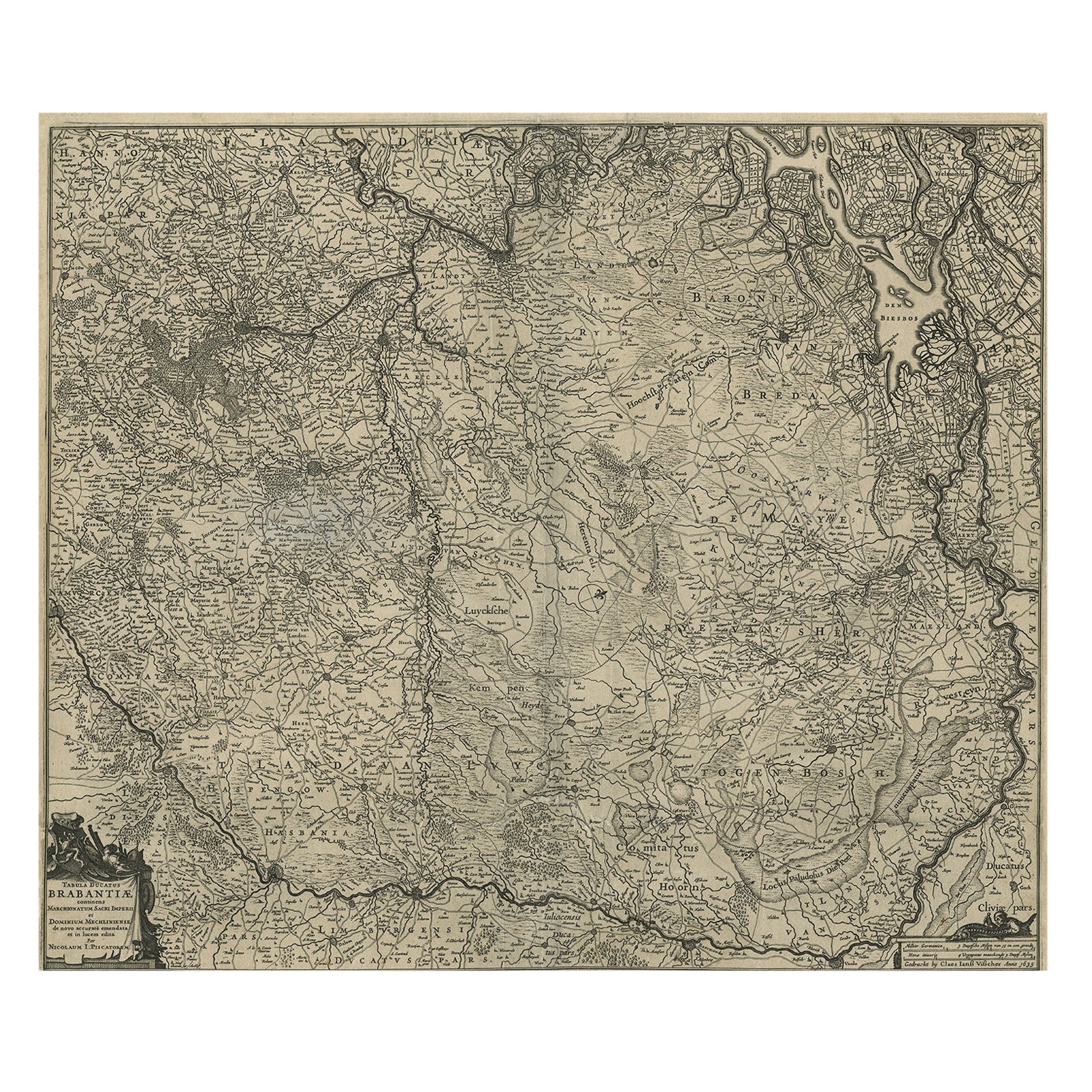
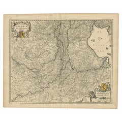
Antique Map of Brabant
The Netherlands
by N. Visscher, circa 1670
$596.14
$745.1820% Off
£441.58
£551.9820% Off
€496
€62020% Off
CA$815.50
CA$1,019.3820% Off
A$888.86
A$1,111.0720% Off
CHF 469.93
CHF 587.4120% Off
MX$10,700.14
MX$13,375.1720% Off
NOK 5,964.59
NOK 7,455.7320% Off
SEK 5,468.31
SEK 6,835.3820% Off
DKK 3,779.25
DKK 4,724.0620% Off
About the Item
Detailed map of the southern part of The Netherlands and the northern part of Belgium with Antwerp and Brussels. In the corner top left in Holland with Rotterdam partly on the map. Small cartouche with a coat of arms. Rare and early edition.
- Dimensions:Height: 20.79 in (52.8 cm)Width: 25.04 in (63.6 cm)Depth: 0.02 in (0.5 mm)
- Materials and Techniques:
- Period:Mid-17th Century
- Date of Manufacture:circa 1670
- Condition:Minor fading. Few stains. Please study image carefully.
- Seller Location:Langweer, NL
- Reference Number:Seller: BG-091761stDibs: LU305439942121
About the Seller
5.0
Recognized Seller
These prestigious sellers are industry leaders and represent the highest echelon for item quality and design.
Platinum Seller
Premium sellers with a 4.7+ rating and 24-hour response times
Established in 2009
1stDibs seller since 2017
2,813 sales on 1stDibs
Typical response time: 1 hour
- ShippingRetrieving quote...Shipping from: Langweer, Netherlands
- Return Policy
More From This Seller
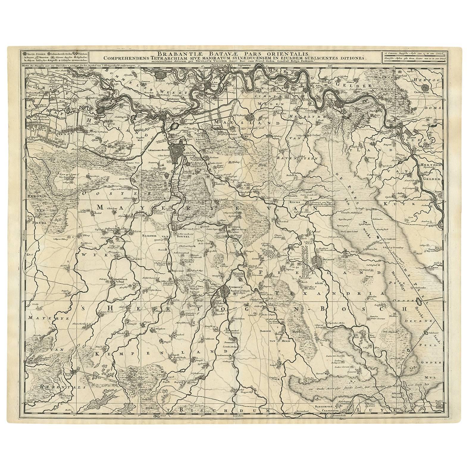
View AllAntique Map of Brabant
The Netherlands
by N. Visscher, circa 1690
Located in Langweer, NL
Antique map titled 'Brabantiae Batavae pars orientalis, comprehendens Tetrarchiam sive majoratum sylvaeducensem in ejusdem subjacentes ditiones (..)'. Map of the Dutch province 'Brab...
Category
Antique Mid-18th Century Dutch Maps
Materials
Paper
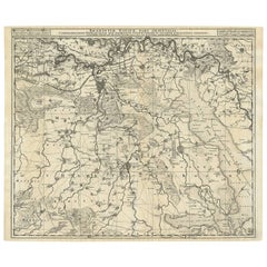
$576 Sale Price
20% Off
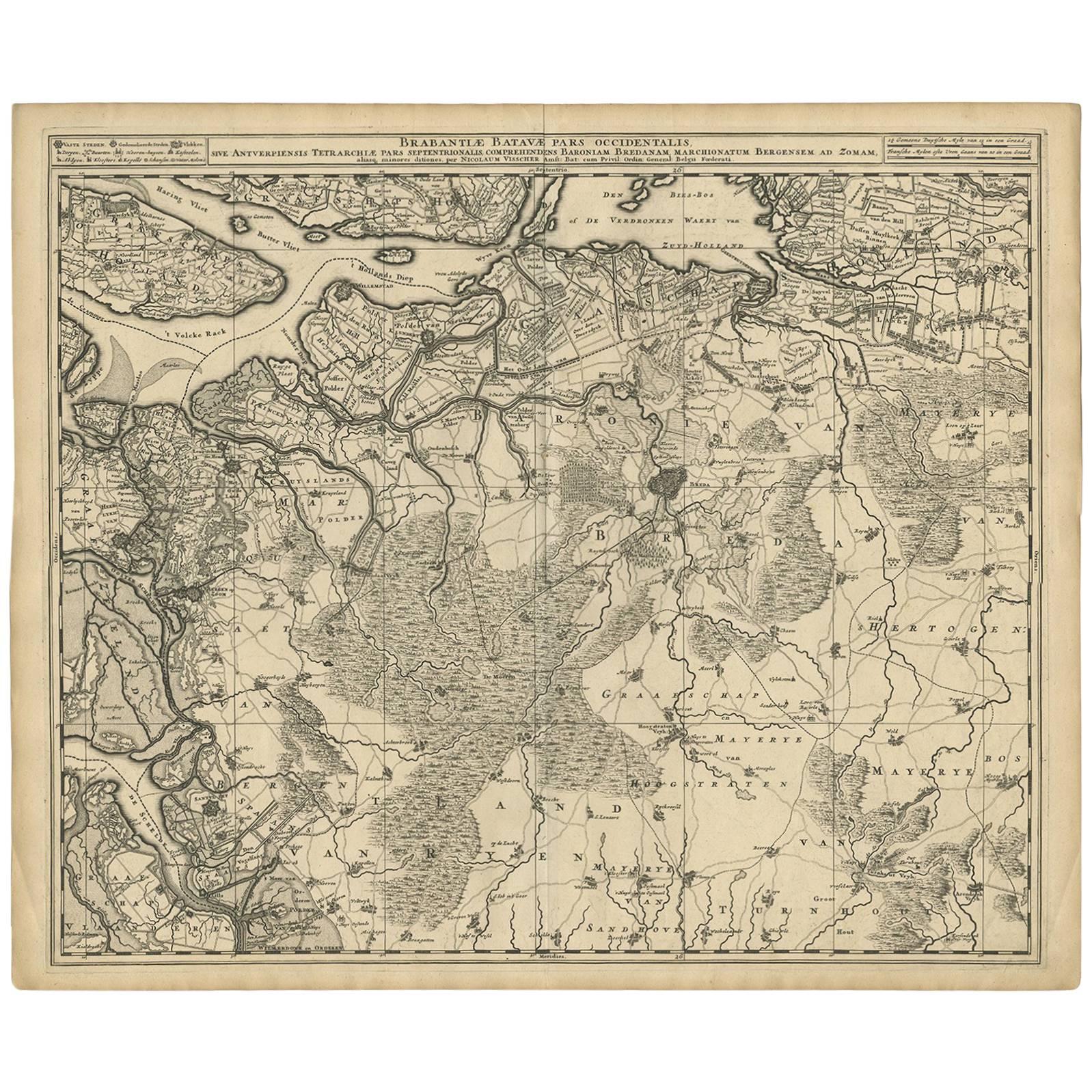
Antique Map of Brabant
The Netherlands
by N. Visscher, circa 1690
Located in Langweer, NL
Antique map titled 'Brabantiae Batavae Pars Occidentalis (..)'. Highly detailed map of the region between Bergen Op Zoom, Breda, Hoogstraten and Sandvliet, The Netherlands. Published...
Category
Antique Late 17th Century Maps
Materials
Paper
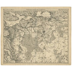
$634 Sale Price
20% Off
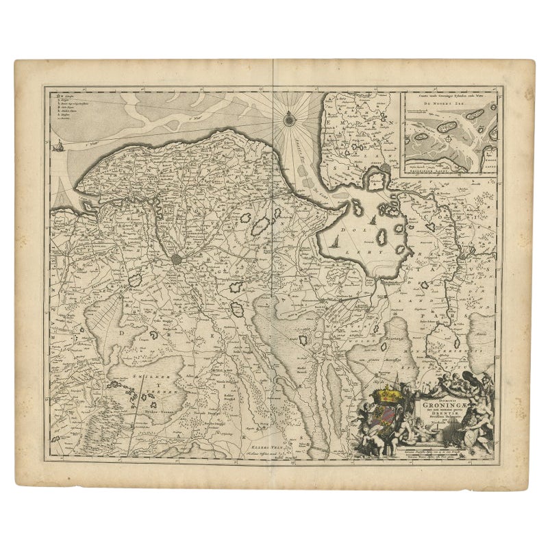
Antique Map of the Dutch Provinces Groningen and Drenthe, C.1660
Located in Langweer, NL
Antique map titled 'Dominii Groningae nec non maximae partis Drentiae (..)'. Map of Groningen and Drenthe in the north-east part of the Netherlands. Inset upper right corner of the "...
Category
Antique 17th Century Maps
Materials
Paper

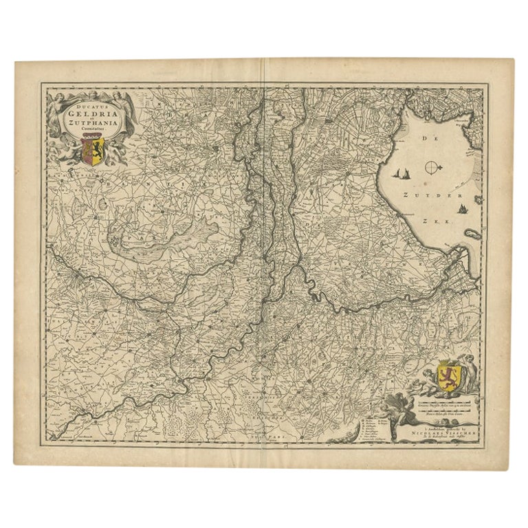
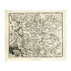
Antique Map of the Dutch Province of Gelderland by Visscher, c.1670
Located in Langweer, NL
Antique map titled 'Ducatus Geldria et Zutphania Comitatus'. Map of the Duchy of Gelre (Gelderland) and the county of Zutphen, The Netherlands. Artists and Engravers: Made after the ...
Category
Antique 17th Century Maps
Materials
Paper
Detailed Map of the South of the The Netherlands
The North of Belgium, ca.1680
Located in Langweer, NL
Antique map titled 'Tabula Ducatus Brabantiae.' - Detailed map of the southern part of The Netherlands and the northern part of Belgium with Antwerp and Brussels. In the corner top l...
Category
Antique 1680s Maps
Materials
Paper
$644 Sale Price
20% Off
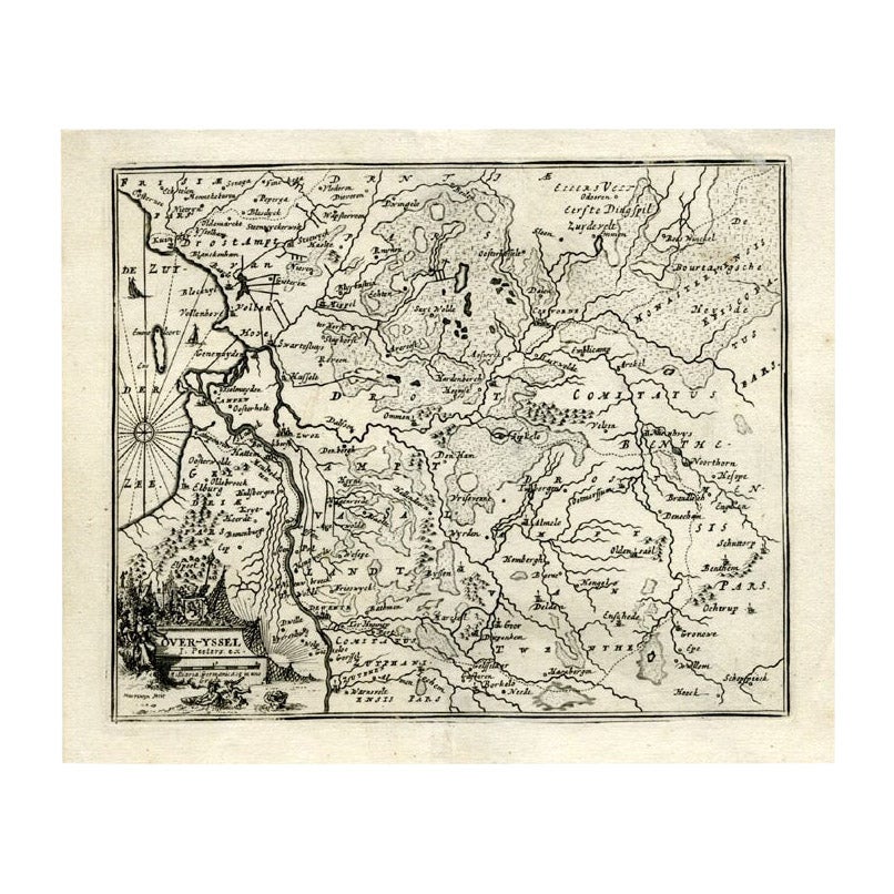
Antique Map of Overijssel by Bachiene, 1758
Located in Langweer, NL
Antique map titled 'Over-Yssel'. Map of the Overijssel, the Netherlands. This map originates from 'Kort begrip der Oude en Nieuwe Staatkundige Geographie', by W.A. Bachiene, publishe...
Category
Antique 18th Century Maps
Materials
Paper
$163 Sale Price
20% Off
You May Also Like
1752 Vaugoundy Map of Flanders : Belgium, France, and the Netherlands, Ric.a002
Located in Norton, MA
Large Vaugoundy Map of Flanders:
Belgium, France, and the Netherlands
Colored -1752
Ric.a002
Description: This is a 1752 Didier Robert de Vaugondy map of Flanders. The map de...
Category
Antique 17th Century Unknown Maps
Materials
Paper

1635 Willem Blaeu Map of Northern France"Comitatvs Bellovacvm" Ric.a08
Located in Norton, MA
1635 Willem Blaeu map of northern France, entitled.
"Comitatvs Bellovacvm Vernacule Beavvais,"
Colored
Ric.a008
“COMITATVS BELLOVACVM…” Amsterdam: W...
Category
Antique 17th Century Unknown Maps
Materials
Paper

1657 Janssonius Map of Vermandois and Cappelle, Ric. A-004
Located in Norton, MA
1657 Janssonius map of
Vermandois and Cappelle
Ric.a004
Description: Antique map of France titled 'Descriptio Veromanduorum - Gouvernement de la Cappelle'. Two detailed maps o...
Category
Antique 17th Century Unknown Maps
Materials
Paper

1640 Joan Bleau Map Entitled"Diocecese de rheims et le pais de rethel, " Eic.a011
Located in Norton, MA
1640 Joan Bleau map entitled
"Diocecese de rheims et le pais de rethel,"
Ric.a011
OAN BLAEU
Diocecese de Rheims, et le pais de Rethel.
Handcolored engraving, c.1640.
...
Category
Antique 17th Century Dutch Maps
Materials
Paper

1643 Willem&Joan Blaeu Map NW Flanders "Flandriae Teutonicae Pars Prientalior
Located in Norton, MA
1643 Willem and Joan Blaeu map of northwest Flanders, entitled
"Flandriae Teutonicae Pars Prientalior,"
Ric0012
" Authentic" - Map of the northwest Fl...
Category
Antique 17th Century Dutch Maps
Materials
Paper

17th Century Hand Colored Map of the Liege Region in Belgium by Visscher
By Nicolaes Visscher II
Located in Alamo, CA
An original 17th century map entitled "Leodiensis Episcopatus in omnes Subjacentes Provincias distincté divisusVisscher, Leodiensis Episcopatus" by Nicolaes Visscher II, published in Amsterdam in 1688. The map is centered on Liege, Belgium, includes the area between Antwerp, Turnhout, Roermond, Cologne, Trier and Dinant.
This attractive map is presented in a cream-colored mat measuring 30" wide x 27.5" high. There is a central fold, as issued. There is minimal spotting in the upper margin and a tiny spot in the right lower margin, which are under the mat. The map is otherwise in excellent condition.
The Visscher family were one of the great cartographic families of the 17th century. Begun by Claes Jansz Visscher...
Category
Antique Late 17th Century Dutch Maps
Materials
Paper

$940 Sale Price
20% Off
More Ways To Browse
Mid Century Modern Corner Chair
Dining Tables With Brass Inlay
Oak Mid Century Armchair
Solid Wood Side Table Stool
Antique Marble Top Hall Table
Old Carpet
Porcelain Modern Hand Painted
Bent Plywood
1960 Italian Dining Set
Italian Giltwood Table
Polished Bronze Table
Antique Laurel Wreath
Armchair In France
Green Oushak
Interlocking Tables
Mid Century Norwegian Furniture
Round Side Table With Glass Top
Vintage Netherlands