Items Similar to Antique Map of Brabant and part of Belgium by Munster, c.1580


Want more images or videos?
Request additional images or videos from the seller
1 of 5
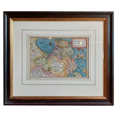
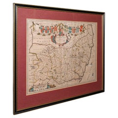
Antique Map of Brabant and part of Belgium by Munster, c.1580
$403.43
£300.86
€340
CA$561.56
A$602.68
CHF 323.06
MX$7,252.95
NOK 4,073.30
SEK 3,714.28
DKK 2,590.59
About the Item
Antique map titled 'Braband'. Original woodcut print of the region of Brabant (the Netherlands) and part of Belgium. Charming miniature originating from 'Cosmographia' by S. Munster.
Artists and Engravers: Sebastian Munster was a German cartographer, cosmographer and Christian scholar. He is best known for Cosmographia, the earliest German description of the world (in 6 parts. He was also the author of Horologiographia, Organum Uranicum and Rudimenta Mathematica. The woodcuts in this publication were made by a group of artists, among which Hans Holbein, Conrad Schnitt, David Kandel and Hans Rudolf Manuel Deutsch.
Condition: Good, general age-related toning. Small crease/wrinkle. Frame included, with wear. Please study image carefully.
Date: c.1580
Overall size: 23 x 19.5 cm.
We sell original antique maps to collectors, historians, educators and interior decorators all over the world. Our collection includes a wide range of authentic antique maps from the 16th to the 20th centuries. Buying and collecting antique maps is a tradition that goes back hundreds of years. Antique maps have proved a richly rewarding investment over the past decade, thanks to a growing appreciation of their unique historical appeal. Today the decorative qualities of antique maps are widely recognized by interior designers who appreciate their beauty and design flexibility. Depending on the individual map, presentation, and context, a rare or antique map can be modern, traditional, abstract, figurative, serious or whimsical. We offer a wide range of authentic antique maps for any budget.
- Dimensions:Height: 7.68 in (19.5 cm)Width: 9.06 in (23 cm)Depth: 0 in (0.01 mm)
- Materials and Techniques:
- Period:
- Date of Manufacture:c.1580
- Condition:
- Seller Location:Langweer, NL
- Reference Number:Seller: BG-000671stDibs: LU3054326083082
About the Seller
5.0
Recognized Seller
These prestigious sellers are industry leaders and represent the highest echelon for item quality and design.
Platinum Seller
Premium sellers with a 4.7+ rating and 24-hour response times
Established in 2009
1stDibs seller since 2017
2,830 sales on 1stDibs
Typical response time: 1 hour
- ShippingRetrieving quote...Shipping from: Langweer, Netherlands
- Return Policy
More From This Seller
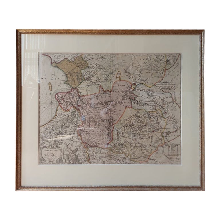
View AllAntique Map of Overijssel by Visscher, c.1660
Located in Langweer, NL
Antique map titled 'Transisalania provincia vulgo Over-yssel'. Original antique map of the province of Overijssel, the Netherlands. Published by N. Visscher after N. ten Have, circa ...
Category
Antique 17th Century Maps
Materials
Paper

$700 Sale Price
20% Off
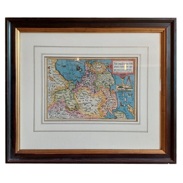
Antique Map of Friesland by Bussemacher in Frame, c.1592
Located in Langweer, NL
Original antique map titled 'Frisiae Antiquissimae (..)'. Original antique map of Friesland. Published by J. Bussemacher, circa 1592. Artists and Engravers: Bussemacher was active as...
Category
Antique 18th Century Maps
Materials
Paper
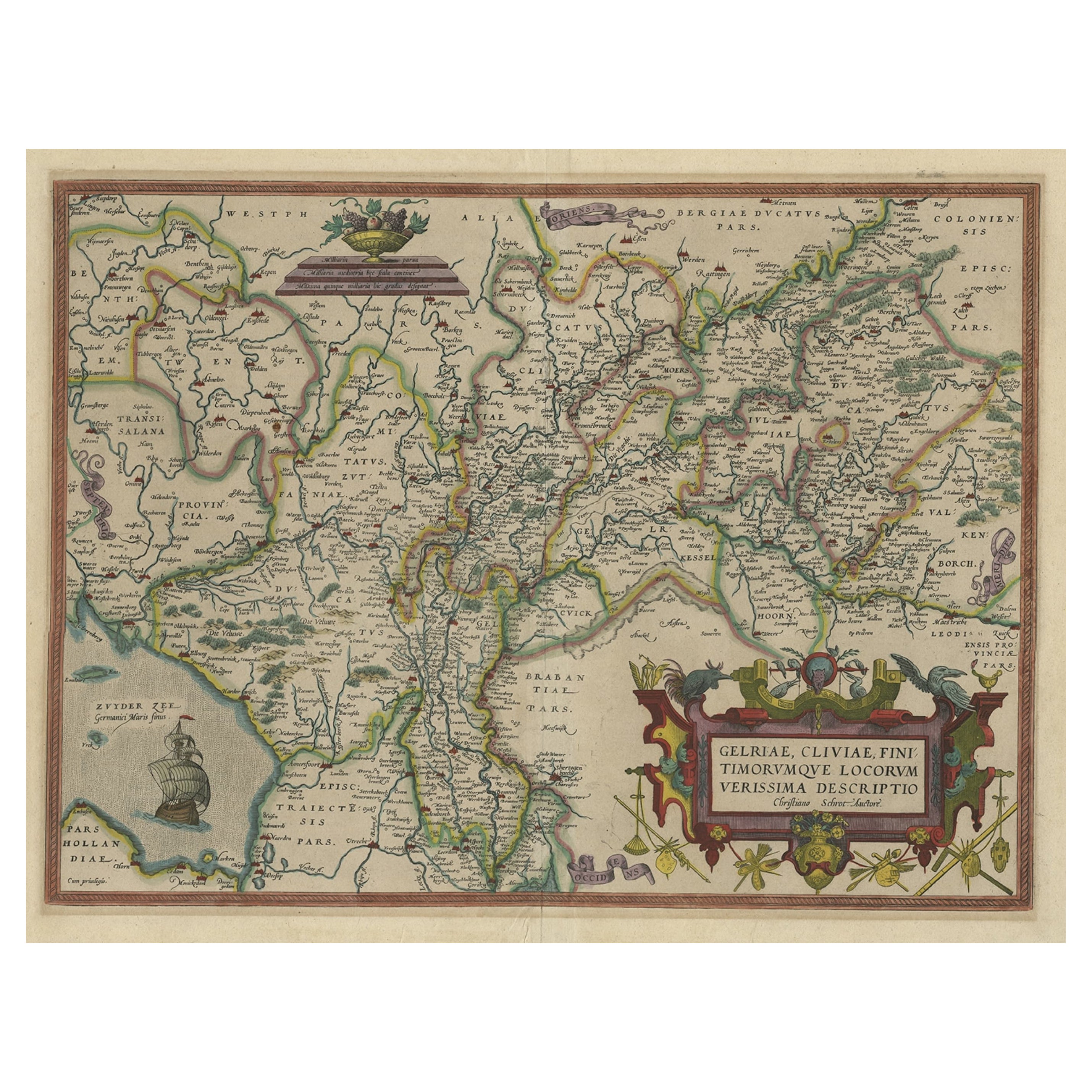
Superb Antique Map of the Province of Gelderland, the Netherlands, ca.1575
Located in Langweer, NL
Antique map titled 'Gelriae, Cliviae, Finitimorumque Locorum Verissima Descriptio Christiano Schrot. Auctore'.
This superb map is Ortelius' first plate covering Gelderland. It is b...
Category
Antique 16th Century Maps
Materials
Paper
Antique Map of the Hainaut and Namur Region by Janssonius,
circa 1640
By Johannes Janssonius
Located in Langweer, NL
Antique map titled 'Comitatuum Hannoniae et Namurci Descriptio'. Old map of the region of Hainaut and Namur, France. Published by J. Janssonius, circa 1640.
Category
Antique Mid-17th Century Maps
Materials
Paper

Antique Map of the Region of Beauvais by Hondius, circa 1630
Located in Langweer, NL
Antique map titled 'Beauvaisis - Comitatus Belovacium'. Old map of the region of Beauvais, France. This map originates from a composite atlas and is signed by J. Hondius.
Category
Antique Mid-17th Century Maps
Materials
Paper

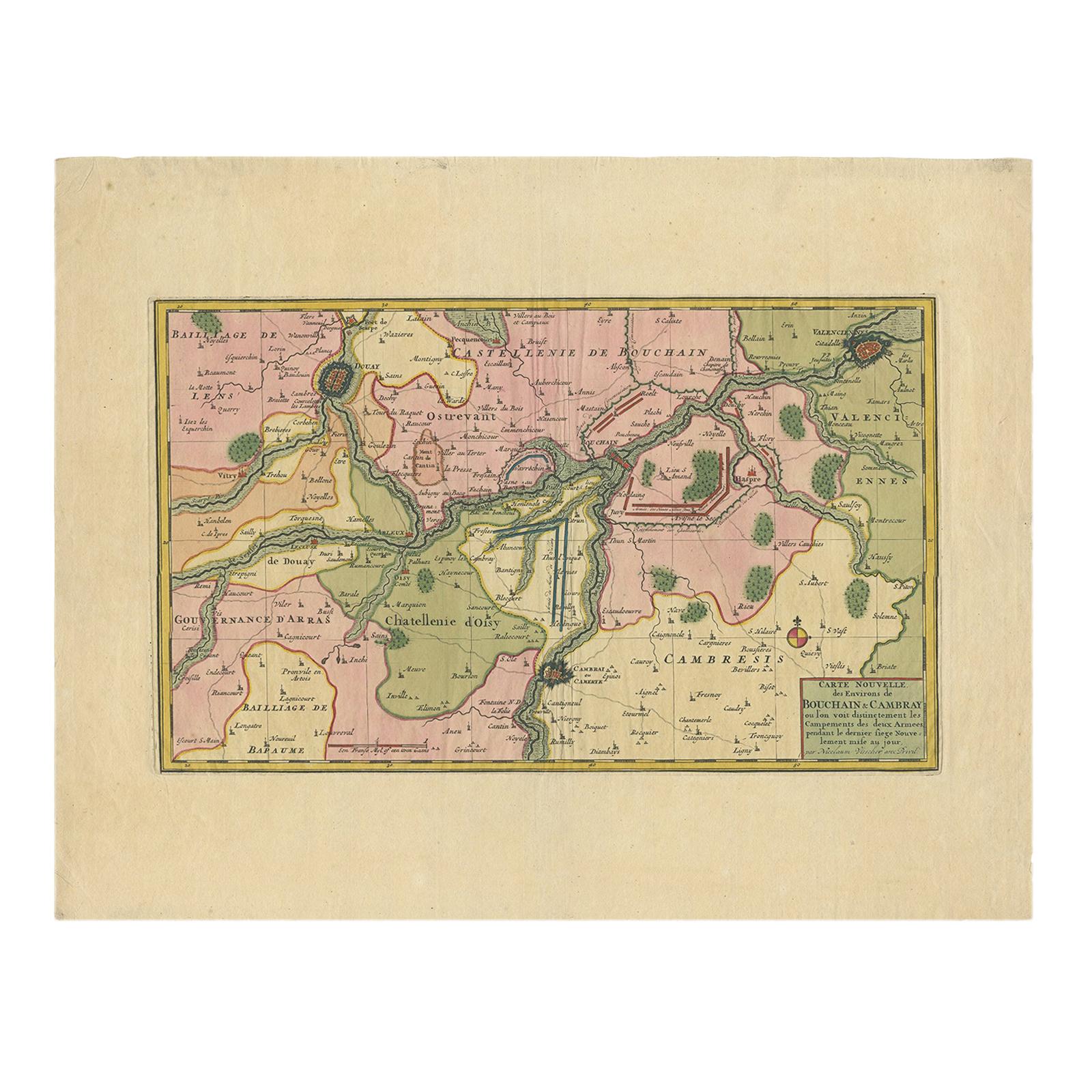
Antique Map of the Region of Bouchain and Cambrai by Visscher
circa 1680
By Nicolaes Visscher II
Located in Langweer, NL
Antique map titled 'Carte Nouvelle des Environs de Bouchain & Cambray'. Uncommon map of the region of Bouchain and Cambrai (Cambray, France) showing the camps of two armies.
Category
Antique Late 17th Century Maps
Materials
Paper
You May Also Like
Antique Map of Bohemia, Dutch, Framed Cartography, Johannes Janssonius, C.1630
Located in Hele, Devon, GB
This is an antique map of Bohemia. A Dutch, framed atlas engraving of modern day Germany, Austria and the Czech Republic by Johannes Janssonius, dating to the 17th century and later,...
Category
Antique 17th Century Dutch Baroque Maps
Materials
Glass, Paper
1620 Map of Artois Entitled "Artesia Comitatvs Artois, " by Bleau, Ric.a012
Located in Norton, MA
1640 map of Artois entitled
"Artesia Comitatvs Artois,"
by Bleau
Colored
A-012.
Detailed map of the northern province of Artois, France on the border with Belgium. Feature...
Category
Antique 17th Century Dutch Maps
Materials
Paper

1635 Willem Blaeu Map of Northern France"Comitatvs Bellovacvm" Ric.a08
Located in Norton, MA
1635 Willem Blaeu map of northern France, entitled.
"Comitatvs Bellovacvm Vernacule Beavvais,"
Colored
Ric.a008
“COMITATVS BELLOVACVM…” Amsterdam: W...
Category
Antique 17th Century Unknown Maps
Materials
Paper

Antique Suffolk County Map, Dutch, Atlas Novus, Joan Blaeu, Cartography, C.1645
Located in Hele, Devon, GB
This is an antique county map of Suffolk. A Dutch, framed atlas engraving by Joan Blaeu, dating to the 17th century and later.
A treat for the collector or county native, with this ...
Category
Antique 1640s Dutch Charles II Maps
Materials
Glass, Paper
Antique County Map of Cheshire, Dutch, Framed, Cartography, Janssonius, C.1660
Located in Hele, Devon, GB
This is an antique county map of Cheshire. A Dutch, framed atlas engraving by Johannes Janssonius, dating to the 17th century and later.
A treat for the collector or county native,...
Category
Antique Mid-17th Century Dutch Charles II Maps
Materials
Glass, Wood, Paper

1640 Joan Bleau Map Entitled"Diocecese de rheims et le pais de rethel, " Eic.a011
Located in Norton, MA
1640 Joan Bleau map entitled
"Diocecese de rheims et le pais de rethel,"
Ric.a011
OAN BLAEU
Diocecese de Rheims, et le pais de Rethel.
Handcolored engraving, c.1640.
...
Category
Antique 17th Century Dutch Maps
Materials
Paper

More Ways To Browse
Birds Eye View Map
North Africa Map
West Africa Map
Antique Compass Map
Antique Maps California
Biblical Maps
Hungary Map
Maps Of Mediterranean
Treasure Map
Antique Navigational Tools
Mississippi Furniture
Caribbean Antiques
Antique Maps West Indies
Antique Mozambique
Malaysian Antique Furniture
Relief Map
Sur Tout
Antique Civil War Maps