Items Similar to Antique Map of Britain
Ireland with North Sea Detail – 1856 Stülpnagel


Video Loading
Want more images or videos?
Request additional images or videos from the seller
1 of 11
Antique Map of Britain
Ireland with North Sea Detail – 1856 Stülpnagel
$502.63
£376.27
€420
CA$691.93
A$756.42
CHF 400.18
MX$9,051.75
NOK 5,091.70
SEK 4,660.94
DKK 3,199.88
About the Item
Antique Map of the British Isles
North Sea by Stülpnagel, 1856
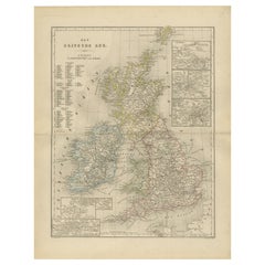
This beautifully detailed 1856 map titled *"Die Britischen Inseln und die Nord-See"* was drawn by F. von Stülpnagel and published by Justus Perthes in Gotha. It presents a rich and accurate cartographic rendering of the British Isles, including England, Scotland, Ireland, and Wales, along with surrounding waters and neighboring parts of mainland Europe.
The British Isles are color-coded by political divisions, with counties and provinces finely delineated and labeled in German. Important cities like London, Edinburgh, Dublin, and Belfast are prominently marked. Ireland is shown in full with its provincial boundaries, while Scotland is mapped with exceptional topographical detail from the Hebrides to the Shetland Islands. Insets include enlarged plans of key naval or urban areas such as London and the Thames Estuary, Plymouth, and Portsmouth, adding practical depth to the cartography.
The map stretches eastward to include the coasts of the Netherlands, Belgium, and parts of western Norway and Denmark, illustrating key sea routes across the North Sea. The maritime theme is reinforced by the title's inclusion of "die Nord-See," emphasizing the importance of naval and trade connectivity in the mid-19th century.
This map is an outstanding example of German cartographic excellence during a period of heightened interest in geography and exploration. It would appeal to collectors of British or maritime history, as well as those interested in 19th-century European cartography.
Condition report:
Very good condition. Light age-toning in the margins. Crisp plate marks and fine hand-coloring. No tears or significant stains.
Framing tips:
Works beautifully with a dark walnut or ebony frame to contrast the pale background. Use a double mat: soft cream with a deep red inner border to echo the detailing of British counties.
Technique: Engraving with original hand coloring
Maker: F. von Stülpnagel / Justus Perthes, Gotha, 1856
- Dimensions:Height: 14.77 in (37.5 cm)Width: 17.88 in (45.4 cm)Depth: 0.01 in (0.2 mm)
- Materials and Techniques:Paper,Engraved
- Place of Origin:
- Period:
- Date of Manufacture:1857
- Condition:Very good condition. Light age-toning in the margins. Crisp plate marks and fine hand-coloring. No tears or significant stains.
- Seller Location:Langweer, NL
- Reference Number:Seller: BG-05552-191stDibs: LU3054346102562
About the Seller
5.0
Recognized Seller
These prestigious sellers are industry leaders and represent the highest echelon for item quality and design.
Platinum Seller
Premium sellers with a 4.7+ rating and 24-hour response times
Established in 2009
1stDibs seller since 2017
2,792 sales on 1stDibs
Typical response time: <1 hour
- ShippingRetrieving quote...Shipping from: Langweer, Netherlands
- Return Policy
More From This Seller
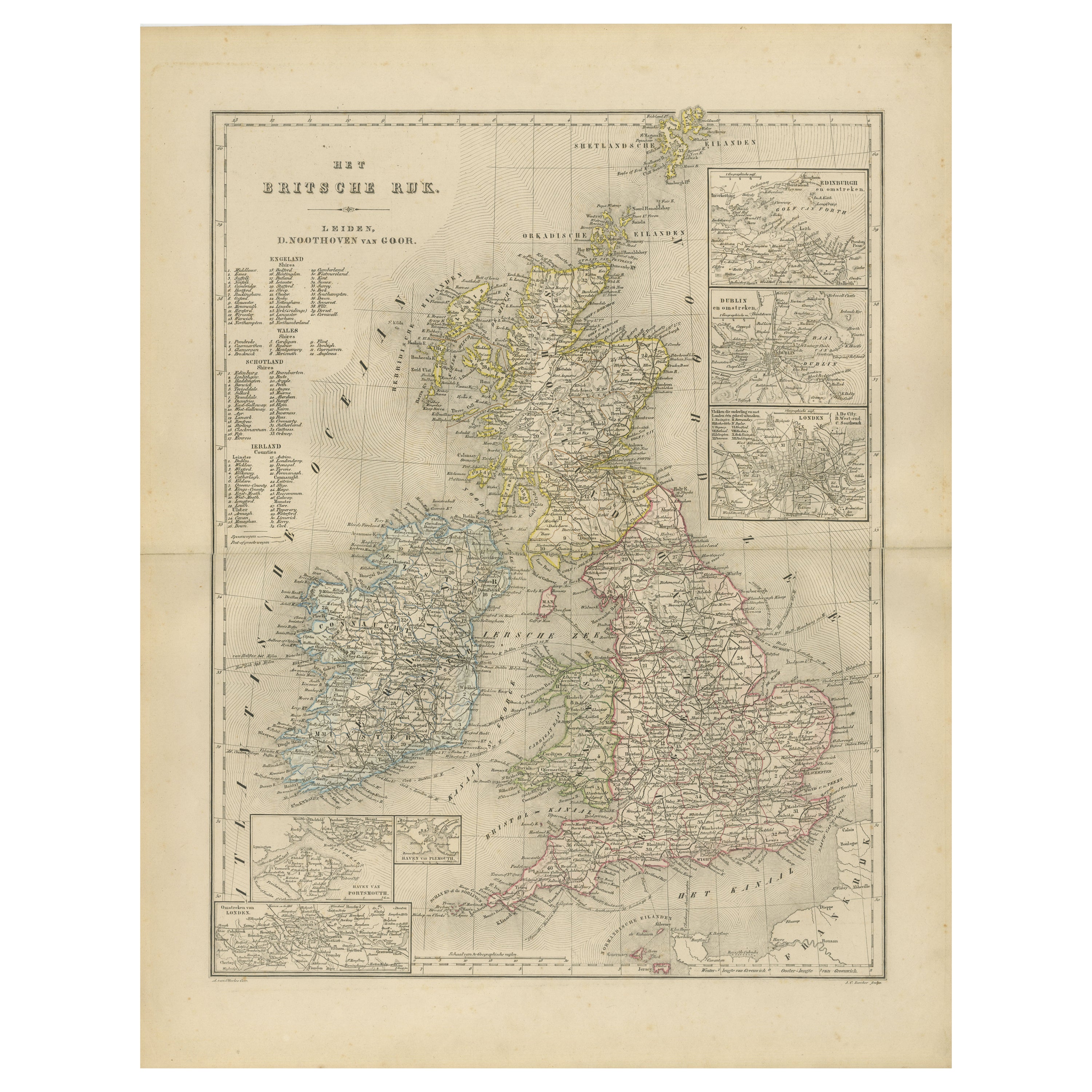
View AllMap of the British Isles with Insets of London and Dublin, Leiden 1876
Located in Langweer, NL
Title: Map of the British Isles with Insets of London and Dublin, Leiden 1876
This detailed 19th-century Dutch map, titled “Het Britsche Rijk,” was published in 1876 in the Nieuwe H...
Category
Antique 1870s Dutch Maps
Materials
Paper
England
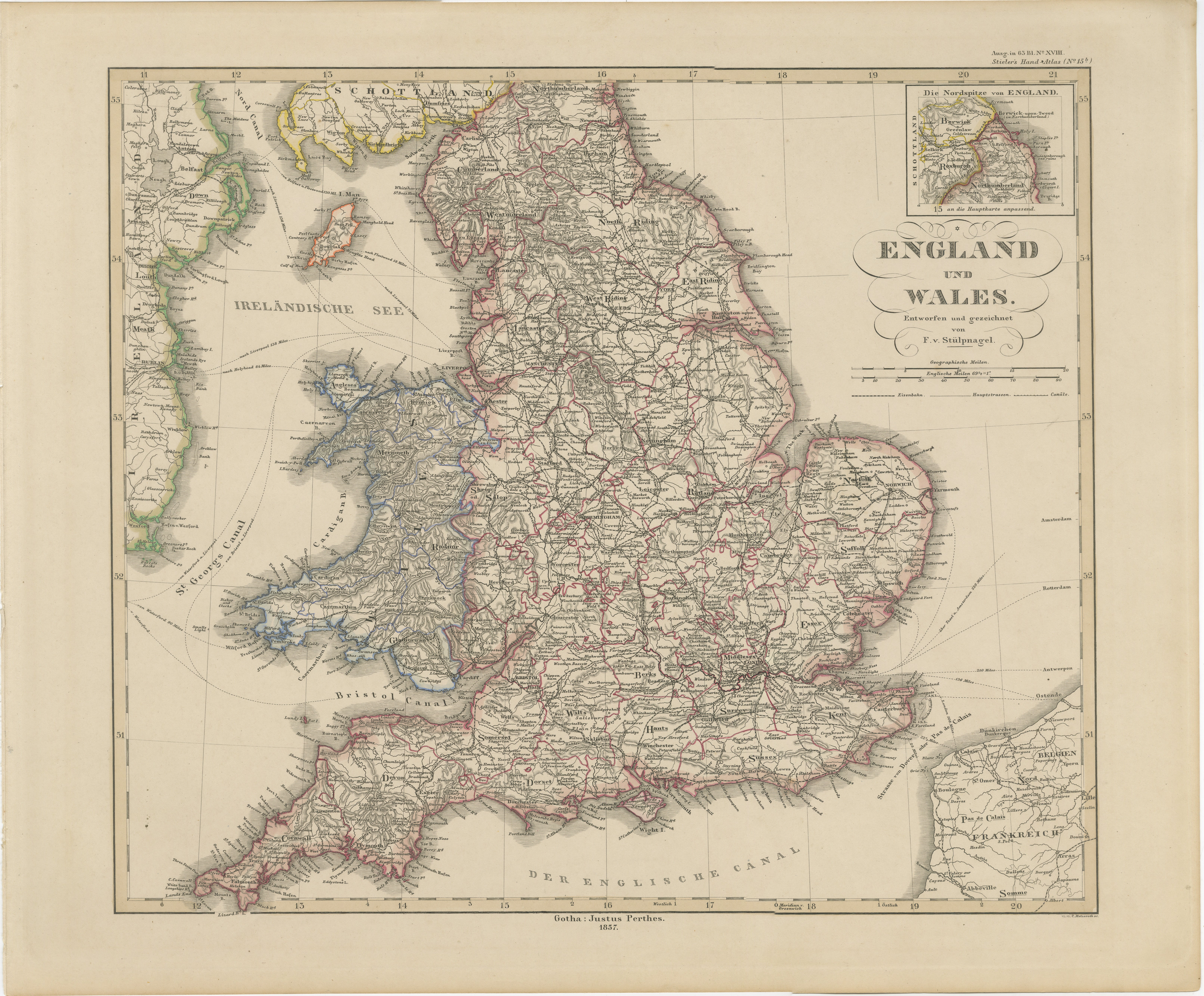
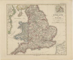
Wales in 1857 – Decorative Antique Map with Rail Routes
Located in Langweer, NL
Antique Map of England & Wales – Hand-Colored Engraving by Stülpnagel, 1857
Fine 19th-century map titled "England und Wales", drawn and engraved by Friedrich von Stülpnagel and publ...
Category
Antique Mid-19th Century German Maps
Materials
Paper
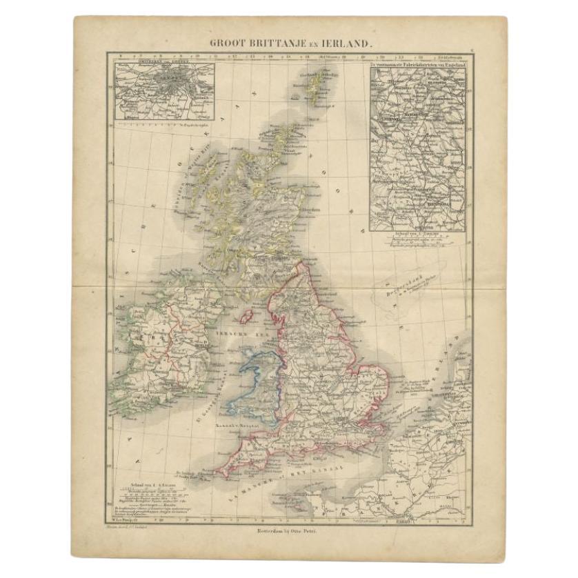
Antique Map of the United Kingdom and Ireland, c.1873
Located in Langweer, NL
Antique map titled 'Groot Brittanje en Ierland'. Old map depicting the United Kingdom and Ireland, with inset maps of London and factory districts of the UK. This map originates from...
Category
Antique 19th Century Maps
Materials
Paper

$119 Sale Price
20% Off
Antique Map of the United Kingdom and Ireland, 1852
Located in Langweer, NL
Antique map titled 'Groot-Brittanje en Ierland'. Map of the United Kingdom and Ireland. This map originates from 'School-Atlas van alle deelen der Aarde' by Otto Petri.
Artists a...
Category
Antique 19th Century Maps
Materials
Paper

$124 Sale Price
20% Off
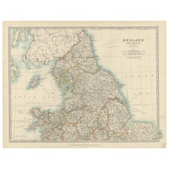
Antique Map of England and Wales, 1903, with Detailed Counties and Railways
Located in Langweer, NL
Title: Antique Map of England and Wales, 1903, with Detailed Counties and Railways
Description:
This beautifully detailed antique map, titled "England and Wales," was engraved and p...
Category
Early 20th Century Maps
Materials
Paper
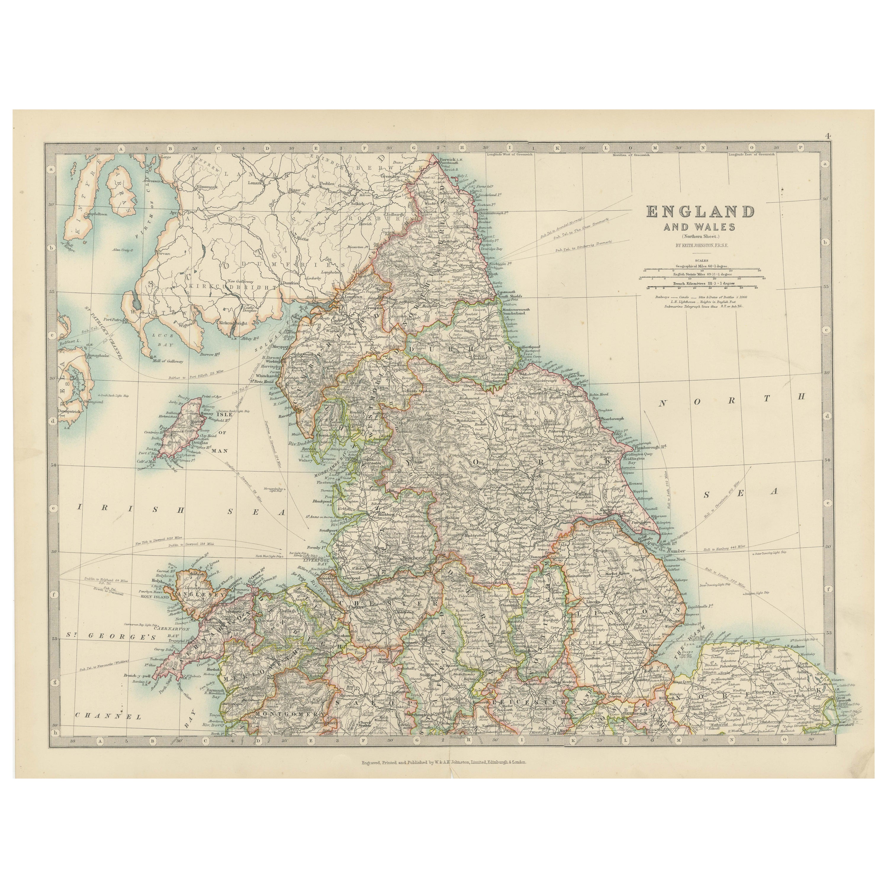
Antique Map of England and Wales
North
by A.K. Johnston, 1865
Located in Langweer, NL
Antique map titled 'England and Wales (Northern Sheet)'. This map originates from the ‘Royal Atlas of Modern Geography’ by Alexander Keith Johnston. Published by William Blackwood an...
Category
Antique Mid-19th Century Scottish Maps
Materials
Paper

You May Also Like
England and Wales, Northern Part. Century Atlas antique vintage map
Located in Melbourne, Victoria
'The Century Atlas. England and Wales, Northern Part'
Original antique map, 1903.
Central fold as issued. Map name and number printed on the reverse corners.
Sheet 29.5cm by 40cm.
Category
Early 20th Century Victorian More Prints
Materials
Lithograph

Original Antique Map of Scotland by Dower, circa 1835
Located in St Annes, Lancashire
Nice map of Scotland
Drawn and engraved by J.Dower
Published by Orr & Smith. C.1835
Unframed.
Free shipping
Category
Antique 1830s English Maps
Materials
Paper

Original Antique Map of Europe, Arrowsmith, 1820
Located in St Annes, Lancashire
Great map of Europe
Drawn under the direction of Arrowsmith.
Copper-plate engraving.
Published by Longman, Hurst, Rees, Orme and Brown, 1820
...
Category
Antique 1820s English Maps
Materials
Paper

Large Original Vintage Map of the United Kingdom, circa 1920
Located in St Annes, Lancashire
Great map of The United Kingdom
Unframed
Original color
By John Bartholomew and Co. Edinburgh Geographical Institute
Published, circa 1920
Free shipping.
Category
Vintage 1920s British Maps
Materials
Paper

Original Antique Map of The World by Dower, circa 1835
Located in St Annes, Lancashire
Nice map of the World
Drawn and engraved by J.Dower
Published by Orr & Smith. C.1835
Unframed.
Free shipping
Category
Antique 1830s English Maps
Materials
Paper

Old British Empire Map - Ancient Map by Karl Spruner - 1760 ca.
By Karl Spruner von Merz
Located in Roma, IT
Old British Empire Map is an artwork realized around 1760 by Karl Spruner.
Original hand-colored print.
Good conditions except for yellowing of pa...
Category
1760s Modern Figurative Prints
Materials
Etching

More Ways To Browse
Danish Key
Beni Ourain Rugs
Glass Top Wood Base Coffee Tables
T Chair
Pair Of Danish Chairs
Veneer Dining Tables
1970 Italian Armchair
Furniture Uk
House Of Denmark Table And Chairs
Louis Marble Top Side Table
Antique Russian Rugs
Baker Furniture By
For Kids
Sterling Silver Flatware Set Service For 12
Tufted Bar
Pair Of French Antique Armchairs
1970s Brass Glass Coffee Table
Antique Column Base