Items Similar to Antique Map of Buckinghamshire in England, 1743


Want more images or videos?
Request additional images or videos from the seller
1 of 5
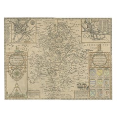
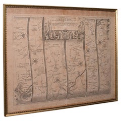
Antique Map of Buckinghamshire in England, 1743
$569.55
£425.19
€480
CA$791.27
A$851.13
CHF 454.87
MX$10,032.37
NOK 5,734.81
SEK 5,242.71
DKK 3,658.14
About the Item
Antique map titled 'Buckingham both shyre and shire towne describ'. Map of Buckinghamshire, England. With town plans of Buckingham and Redding. This map originates from Overton's atlas 'England Fully Described in a Compleat Sett of Mapps of ye County's of England
Wales'.
Artists and Engravers: John Overton (1640-1713) and his son, Henry, produced a number of atlases and maps from 1665 to c.1755. They never possessed a complete set of county map plates and made up their atlases in the early Dutch tradition by using the prints of other publishers, notably the maps of Blaeu and Jansson. Only when these were not available did they arrange for a plate of their own to be produced.
We sell original antique maps to collectors, historians, educators and interior decorators all over the world. Our collection includes a wide range of authentic antique maps from the 16th to the 20th centuries. Buying and collecting antique maps is a tradition that goes back hundreds of years. Antique maps have proved a richly rewarding investment over the past decade, thanks to a growing appreciation of their unique historical appeal. Today the decorative qualities of antique maps are widely recognized by interior designers who appreciate their beauty and design flexibility. Depending on the individual map, presentation, and context, a rare or antique map can be modern, traditional, abstract, figurative, serious or whimsical. We offer a wide range of authentic antique maps for any budget.
- Dimensions:Height: 15.75 in (40 cm)Width: 20.48 in (52 cm)Depth: 0 in (0.01 mm)
- Materials and Techniques:
- Period:
- Date of Manufacture:1743
- Condition:Additions or alterations made to the original: new Japanese paper backing. Condition: Fair, bleached and new Japanese paper backing. Blank verso, please study image carefully.
- Seller Location:Langweer, NL
- Reference Number:Seller: BG-12705-71stDibs: LU3054326085092
About the Seller
5.0
Recognized Seller
These prestigious sellers are industry leaders and represent the highest echelon for item quality and design.
Platinum Seller
Premium sellers with a 4.7+ rating and 24-hour response times
Established in 2009
1stDibs seller since 2017
2,836 sales on 1stDibs
Typical response time: 1 hour
- ShippingRetrieving quote...Shipping from: Langweer, Netherlands
- Return Policy
More From This Seller
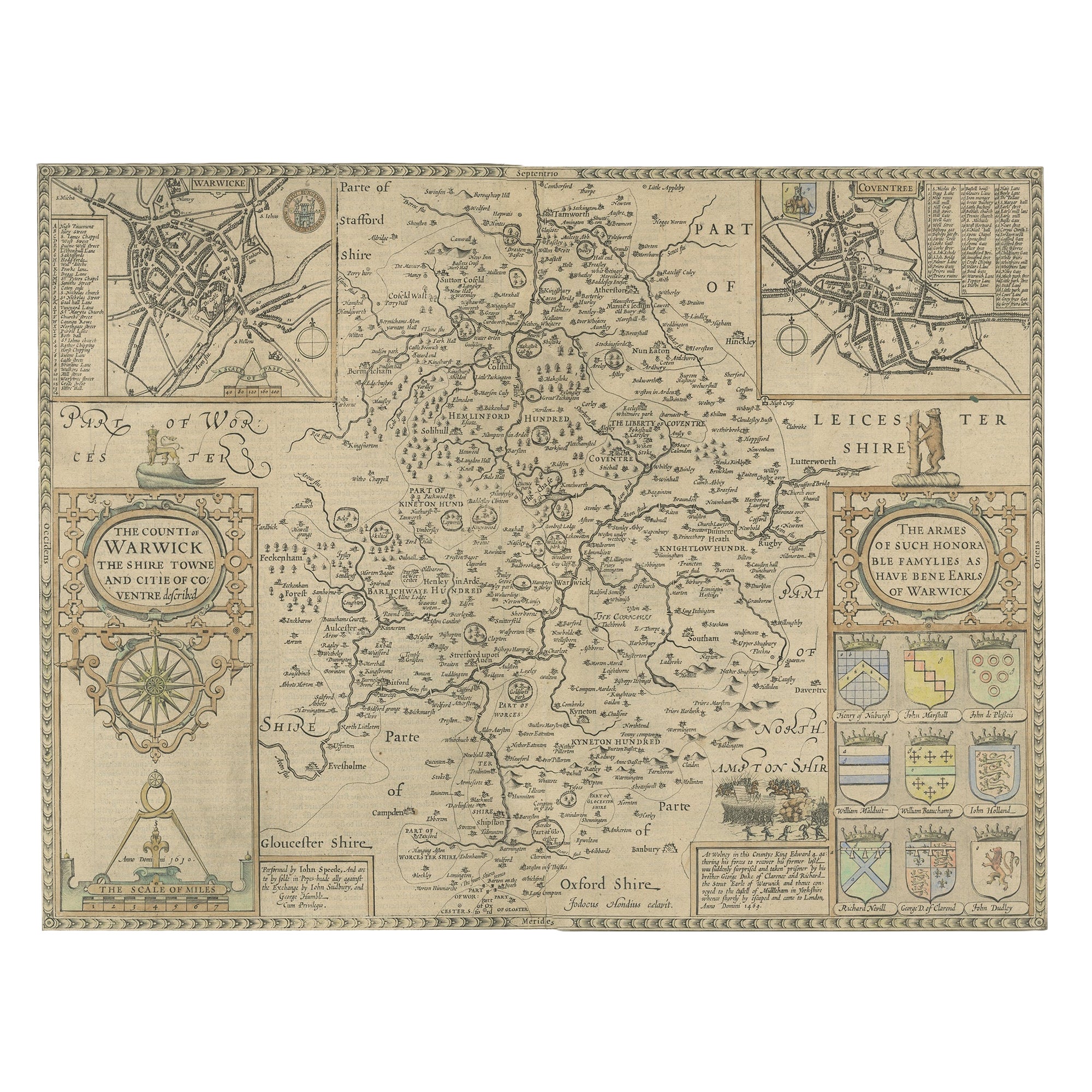
View AllAntique Map of Warwickshire by Speed, c.1614
Located in Langweer, NL
Antique map titled 'The Counti of Warwick (..)'. Map of Warwickshire, England. Includes inset town plans of Warwick and Coventry. This map originates from 'Theatre of Great Britaine'...
Category
Antique 17th Century Maps
Materials
Paper
$446 Sale Price
20% Off
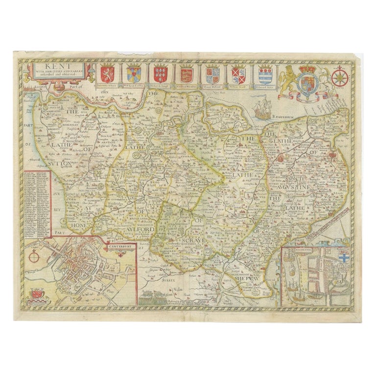
Antique Map of Kent with Inset Plans of Rochester
Canterbury, England, 1676
Located in Langweer, NL
Antique map titled 'Kent with her Cities and Earles described and observed'.
Map of Kent, England. Includes inset town plans of Rochester and Canterbury....
Category
Antique 17th Century Maps
Materials
Paper
Antique Map of Northamptonshire by Speed, 1676
Located in Langweer, NL
Antique map titled 'Norhamtonshire'. Map of Norhamptonshire, England. Includes inset town plans of Peterborough and Northampton. This map originates from 'Theatre of Great Britaine' ...
Category
Antique 17th Century Maps
Materials
Paper

$522 Sale Price
20% Off
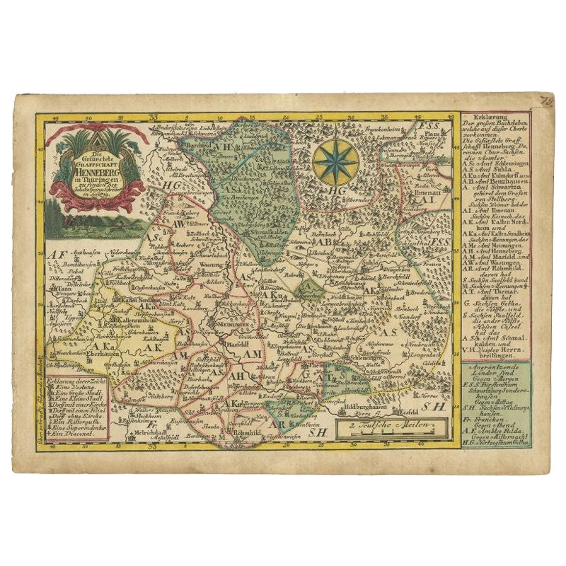
Antique Map of the Region of Henneberg by Schreiber, 1749
Located in Langweer, NL
Antique map titled 'Die Gefürstete Henneberg'. Map of the region of Henneberg, Germany. This map originates from 'Atlas Selectus von allen Konigreichen und L...
Category
Antique 18th Century Maps
Materials
Paper
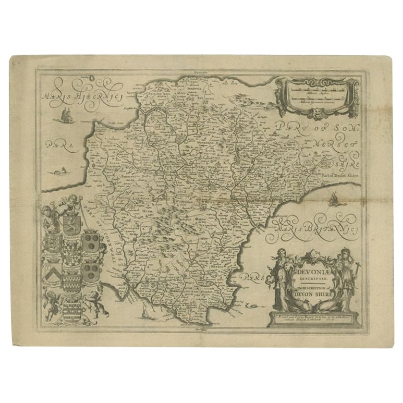
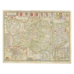
Antique Map of the County of Devon by Overton, 1713
Located in Langweer, NL
Antique map titled 'Devoniae Descriptio - The Description of Devon Shire'. Map of the County of Devon, England. This map originates from the 1713 edition of the 'Overton Atlas'. Henry Overton only revised the Devon map...
Category
Antique 18th Century Maps
Materials
Paper
Antique Map of Hertfordshire in England by Speed, 1627
Located in Langweer, NL
Antique map titled 'Hartfordshire described the sittuations of Hartford (..)'.
Map of Hertfordshire, England. Includes inset maps of Hertford and the Roman settlement of Verolani...
Category
Antique 17th Century Maps
Materials
Paper

You May Also Like
Antique Road Map, London to Hythe, Kent, English, Cartography, John Ogilby, 1675
Located in Hele, Devon, GB
This is an antique Road Map from London to Hythe, Kent. An English, cartographic atlas excerpt by John Ogilby, dating to the late 17th century with later frame, circa 1675
A superb ...
Category
Antique 17th Century British Queen Anne Maps
Materials
Glass, Paper
Antique Stafford County Map, English, Atlas Engraving, 17th Century, Cartography
Located in Hele, Devon, GB
This is an antique Stafford County Map. An English, framed atlas engraving of Staffordshire, dating to the 17th century and later, circa 1676.
Superb cartography reproduction of St...
Category
Antique Late 17th Century British Charles II Maps
Materials
Glass, Paper
Antique County Map, Shropshire, English, Atlas Engraving, Richard Blome, C.1673
Located in Hele, Devon, GB
This is an antique county map of Shropshire. An English, framed atlas engraving by Richard Blome, dating to the 17th century and later.
A treat for the collector or county native, ...
Category
Antique 17th Century British Restauration Maps
Materials
Glass, Wood, Paper

Antique Buckinghamshire Map, English, Framed 17th Century County Cartography
Located in Hele, Devon, GB
This is an antique county map of Buckinghamshire. An English, framed atlas engraving reproduction by Dutchman Joan Blaeu, dating to the 17th century and later.
A treat for the colle...
Category
Early 20th Century British Victorian Maps
Materials
Glass, Paper
Framed 17th Century Map of Cumberland, England by John Speed, 1610
By John Speed
Located in Middleburg, VA
A fascinating and richly detailed antique map of Cumberland County in northwest England, drawn and published by the celebrated English cartographer John Spe...
Category
Antique Early 17th Century English British Colonial Maps
Materials
Copper, Gold Leaf

18th Century Emanuel Bowen Map of County of York, c.1740
By Emanuel Bowen
Located in Royal Tunbridge Wells, Kent
Antique 18th century British rare and original Emanuel Bowen (1694-1767) map of the County of York divided into its Ridings and subdivided into wapontakes, mounted in solid wood fram...
Category
Antique Early 18th Century British Maps
Materials
Paper

More Ways To Browse
Biblical Maps
Maps Of Mediterranean
Treasure Map
Antique Navigational Tools
Mississippi Furniture
Caribbean Antiques
Antique Maps West Indies
Antique Mozambique
Malaysian Antique Furniture
Relief Map
Sur Tout
Antique Civil War Maps
Antique Nautical Maps
Civil War Map
Royal Stuart
Sri Lanka Map
Braun Artist
Hand Painted Antique Map