Want more images or videos?
Request additional images or videos from the seller
1 of 5
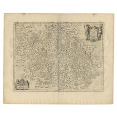
Antique Map of the Burgundy-franche-Comté Region by Janssonius, 1657
Price:$306.41
About the Item
- Dimensions:Height: 19.69 in (50 cm)Width: 23.63 in (60 cm)Depth: 0 in (0.01 mm)
- Materials and Techniques:
- Period:
- Date of Manufacture:1657
- Condition:
- Seller Location:Langweer, NL
- Reference Number:Seller: BG-12082-481stDibs: LU3054327771742
About the Seller
5.0
Recognized Seller
These prestigious sellers are industry leaders and represent the highest echelon for item quality and design.
Platinum Seller
Premium sellers with a 4.7+ rating and 24-hour response times
Established in 2009
1stDibs seller since 2017
2,819 sales on 1stDibs
Typical response time: 1 hour
Authenticity Guarantee
In the unlikely event there’s an issue with an item’s authenticity, contact us within 1 year for a full refund. DetailsMoney-Back Guarantee
If your item is not as described, is damaged in transit, or does not arrive, contact us within 7 days for a full refund. Details24-Hour Cancellation
You have a 24-hour grace period in which to reconsider your purchase, with no questions asked.Vetted Professional Sellers
Our world-class sellers must adhere to strict standards for service and quality, maintaining the integrity of our listings.Price-Match Guarantee
If you find that a seller listed the same item for a lower price elsewhere, we’ll match it.Trusted Global Delivery
Our best-in-class carrier network provides specialized shipping options worldwide, including custom delivery.You May Also Like
1657 Janssonius Map of Vermandois and Cappelle, Ric. A-004
Located in Norton, MA
1657 Janssonius map of
Vermandois and Cappelle
Ric.a004
Description: Antique map of France titled 'Descriptio Veromanduorum - Gouvernement de la Cappelle'. Two detailed maps o...
Category
Antique 17th Century Unknown Maps
Materials
Paper

17th Century Hand-Colored Map of a Region in West Germany by Janssonius
By Johannes Janssonius
Located in Alamo, CA
This attractive highly detailed 17th century original hand-colored map is entitled "Archiepiscopatus Maghdeburgensis et Anhaltinus Ducatus cum terris adjacentibus". It was published ...
Category
Antique Mid-17th Century Dutch Maps
Materials
Paper

$1,020 Sale Price
20% Off
H 27.5 in W 30 in D 0.13 in
Antique County Map, Buckinghamshire, Bedfordshire, Dutch, Framed, Janssonius
Located in Hele, Devon, GB
This is an antique county map of Buckinghamshire and Bedfordshire. A Dutch, framed atlas engraving by Johannes Janssonius, dating to the 17th century and later.
A treat for the col...
Category
Antique Mid-17th Century Dutch Maps
Materials
Paper

$1,661
H 24.02 in W 27.76 in D 0.79 in
Antique County Map of Cheshire, Dutch, Framed, Cartography, Janssonius, C.1660
Located in Hele, Devon, GB
This is an antique county map of Cheshire. A Dutch, framed atlas engraving by Johannes Janssonius, dating to the 17th century and later.
A treat for the collector or county native,...
Category
Antique Mid-17th Century Dutch Charles II Maps
Materials
Glass, Wood, Paper

$2,280
H 22.05 in W 25.99 in D 0.99 in
1594 Maurice Bouguereau Map of the Region Limoges, France, Ric0015
Located in Norton, MA
1594 Maurice Bouguereau map of the region Limoges, France, entitled
"Totivs Lemovici et Confinium Pro Uinciarum Quantum ad Dioecefin Lemo Uicenfen Fpectant,"
Hand Colored
Ric0015
Jean IV Le Clerc...
Category
Antique 16th Century Dutch Maps
Materials
Paper

$2,425
H 15.36 in W 21.26 in D 0.4 in
The Normandy Region of France: A 17th C. Hand-colored Map by Sanson and Jaillot
By Nicolas Sanson
Located in Alamo, CA
This large hand-colored map entitled "Le Duché et Gouvernement de Normandie divisée en Haute et Basse Normandie en divers Pays; et par evêchez, avec le Gouvernement General du Havre ...
Category
Antique 1690s French Maps
Materials
Paper

$1,900 Sale Price
20% Off
H 24.88 in W 38 in D 0.13 in
17th Century Hand Colored Map of the Liege Region in Belgium by Visscher
By Nicolaes Visscher II
Located in Alamo, CA
An original 17th century map entitled "Leodiensis Episcopatus in omnes Subjacentes Provincias distincté divisusVisscher, Leodiensis Episcopatus" by Nicolaes Visscher II, published in Amsterdam in 1688. The map is centered on Liege, Belgium, includes the area between Antwerp, Turnhout, Roermond, Cologne, Trier and Dinant.
This attractive map is presented in a cream-colored mat measuring 30" wide x 27.5" high. There is a central fold, as issued. There is minimal spotting in the upper margin and a tiny spot in the right lower margin, which are under the mat. The map is otherwise in excellent condition.
The Visscher family were one of the great cartographic families of the 17th century. Begun by Claes Jansz Visscher...
Category
Antique Late 17th Century Dutch Maps
Materials
Paper

$940 Sale Price
20% Off
H 27.5 in W 30 in D 0.13 in
18th Century Map of French Pyrenees Region of France
Located in Haddonfield, NJ
An antique map titled "Principatus Benearnia, La Principaute De Bearn" created by the renowned Dutch cartographer Willem Janszoon Blaeu.
It depicts the Principality of Bearn, a histo...
Category
Antique 1880s Danish Baroque Maps
Materials
Wood, Paper

Original Antique Map of The Philippines. C.1900
Located in St Annes, Lancashire
Fabulous map of The Philippines
Original color.
Engraved and printed by the George F. Cram Company, Indianapolis.
Published, C.1900.
Unframed.
Free shipping.
Category
Antique 1890s American Maps
Materials
Paper

Prussia, Poland, N. Germany, Etc: A Hand-colored 17th Century Map by Janssonius
By Johannes Janssonius
Located in Alamo, CA
This is an attractive hand-colored copperplate engraved 17th century map of Prussia entitled "Prussia Accurate Descripta a Gasparo Henneberg Erlichensi", published in Amsterdam by Joannes Janssonius in 1664. This very detailed map from the golden age of Dutch cartography includes present-day Poland, Latvia, Lithuania, Estonia and portions of Germany. This highly detailed map is embellished by three ornate pink, red, mint green and gold...
Category
Antique Mid-17th Century Dutch Maps
Materials
Paper

$1,020 Sale Price
20% Off
H 21.25 in W 24.63 in D 0.07 in
More From This Seller
View AllAntique Map of the Region of Franche-Comté by Janssonius, circa 1650
Located in Langweer, NL
Antique map titled 'Burgundiae Comitatus Franche Comté'. Old map of the historical and former region of Franche-Comté, France. As a region, it encompasse...
Category
Antique Mid-17th Century Maps
Materials
Paper

Antique Map of the Maine Region by Janssonius, 1657
By Johannes Janssonius
Located in Langweer, NL
Antique map of France titled 'Diocese du Mans vulgo le Mains'. Decorative map of the region of Maine, France. This map originates from 'Atlas Novus, Sive Theatrum Orbis Orbis Terraru...
Category
Antique 17th Century Maps
Materials
Paper

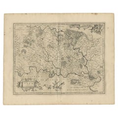
Antique Map of the Region of Bourbon by Janssonius, 1657
Located in Langweer, NL
Antique map of France titled 'Borbonium Ducatus - Bourbonnois'. Decorative map of the Bourbon region. This map originates from 'Atlas Novus, Sive Theatrum Orbis Orbis Terrarum: In qu...
Category
Antique 17th Century Maps
Materials
Paper
Antique Map of the Region of Brie by Janssonius, 1657
Located in Langweer, NL
Antique map of France titled 'Le Pais de Brie'. Old map of the Brie Region, to the east of Paris, between the Marne and the Seine Rivers. This map originates from 'Atlas Novus, Sive ...
Category
Antique 17th Century Maps
Materials
Paper
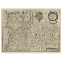
Antique Map of the Region of Dauphiné by Janssonius, 1657
Located in Langweer, NL
Antique map of France titled 'Nova et Accurata descriptio Delphinatus vulgo Dauphiné'. Decorative map of Dauphiné region in France. Originally a seperate province in southeastern Fra...
Category
Antique 17th Century Maps
Materials
Paper
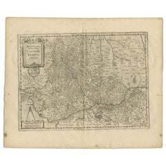
Antique Map of the Region of Beauvais by Janssonius, 1657
Located in Langweer, NL
Antique map of France titled 'Beauvaisis Comitatus Belovacium'. Detailed map of the region centered on Beauvais. This map originates from 'Atlas Novus, Sive Theatrum Orbis Orbis Terr...
Category
Antique 17th Century Maps
Materials
Paper
Still Thinking About These?
All Recently ViewedMore Ways To Browse
Antique Map Burgundy
Antique Alabama Map
Antique Framed Map Engravings
Antique Furniture Cheshire
Antique Great Lakes Map
Antique Map Of Michigan
Antique Map Of Turkish Empire
Antique Map Of Yorkshire
Bali Map
Bermuda Map
British Empire Map
Caucasus Map
Framed London Map
J Warren
Large Framed Maps
Map Of Jamaica
Map Of Madagascar
Map Of Normandy