Items Similar to Antique Map of the Burgundy Region by Mallet, c.1683


Want more images or videos?
Request additional images or videos from the seller
1 of 5
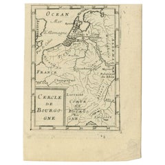
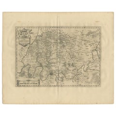
Antique Map of the Burgundy Region by Mallet, c.1683
$73.72
$92.1520% Off
£55.19
£68.9820% Off
€61.60
€7720% Off
CA$101.48
CA$126.8520% Off
A$110.94
A$138.6820% Off
CHF 58.69
CHF 73.3720% Off
MX$1,327.59
MX$1,659.4920% Off
NOK 746.78
NOK 933.4820% Off
SEK 683.60
SEK 854.5120% Off
DKK 469.32
DKK 586.6520% Off
About the Item
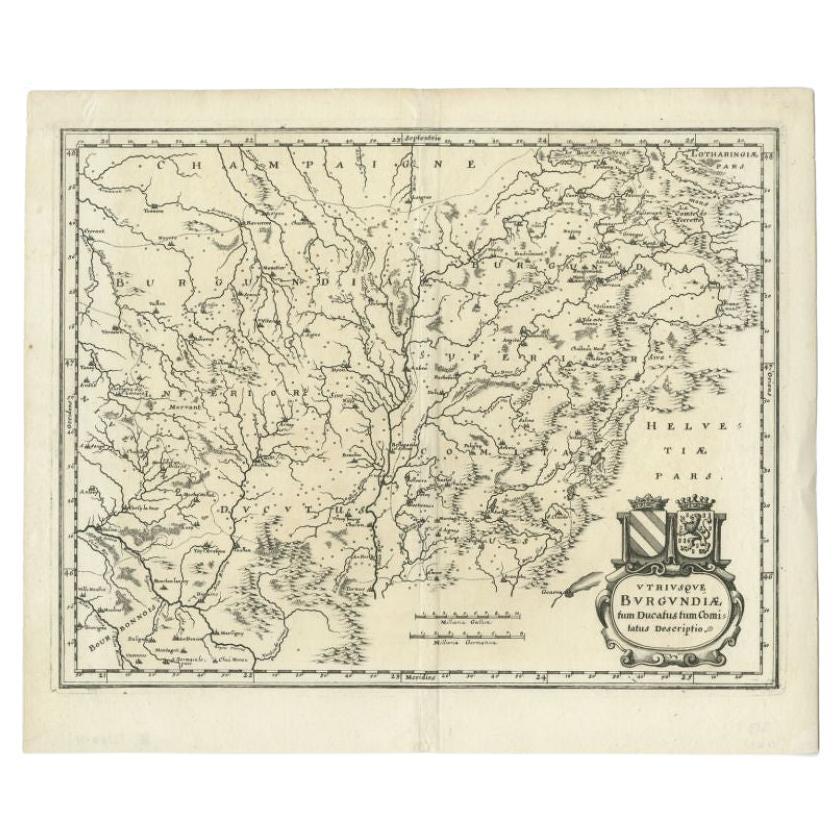
Antique map titled 'Royaume de Bourgogne sous la seconde Race des Roys de France'. Detailed miniature map of the Burgundy region, France. Originates from Mallet's 'Description de l'Univers'. Artists and Engravers: Alain Manneson Mallet (1630-1706) spent the first part of his career as a foot soldier in one the regiments of Louis XIV, becoming a sergeant-major of artillery and then an inspector of fortifications. After leaving the army he specialised in the publication of books describing both scientific and practical aspects of military engineering.
Artist: Alain Manneson Mallet (1630-1706) spent the first part of his career as a foot soldier in one the regiments of Louis XIV, becoming a sergeant-major of artillery and then an inspector of fortifications. After leaving the army he specialised in the publication of books describing both scientific and practical aspects of military engineering.
Condition: Good, general age-related toning. French text on verso, minor wear. Please study image carefully.
Date: c.1683
Overall size: 14 x 19 cm.
Image size: 0.001 x 11 x 16 cm.
Antique prints have long been appreciated for both their aesthetic and investment value. They were the product of engraved, etched or lithographed plates. These plates were handmade out of wood or metal, which required an incredible level of skill, patience and craftsmanship. Whether you have a house with Victorian furniture or more contemporary decor an old engraving can enhance your living space.
- Dimensions:Height: 7.49 in (19 cm)Width: 5.52 in (14 cm)Depth: 0 in (0.01 mm)
- Materials and Techniques:
- Period:
- Date of Manufacture:circa 1683
- Condition:
- Seller Location:Langweer, NL
- Reference Number:Seller: BG-12390-571stDibs: LU3054327771162
About the Seller
5.0
Recognized Seller
These prestigious sellers are industry leaders and represent the highest echelon for item quality and design.
Platinum Seller
Premium sellers with a 4.7+ rating and 24-hour response times
Established in 2009
1stDibs seller since 2017
2,792 sales on 1stDibs
Typical response time: <1 hour
- ShippingRetrieving quote...Shipping from: Langweer, Netherlands
- Return Policy
More From This Seller
View AllAntique Map of the Burgundy Region by Mallet, c.1683
Located in Langweer, NL
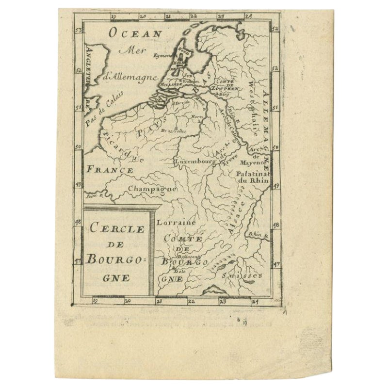
Antique map titled 'Cercle de Bourgogne'. Detailed miniature map of the Burgundy region, France. Also shows the Netherlands and Belgium. Originates from Mallet's 'Description de l'Un...
Category
Antique 17th Century Maps
Materials
Paper
$81 Sale Price
20% Off
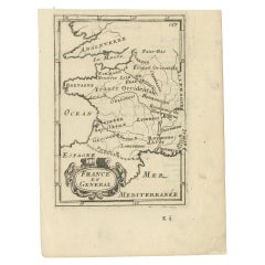
Detailed Antique Miniature Map of France by Mallet, c.1683
Located in Langweer, NL
Antique map titled 'France en General'. BG-11796-55. Originates from Mallet's 'Description de l'Univers'.
Artists and Engravers: Alain Manneson Mallet (1630-1706) spent the first ...
Category
Antique 17th Century Maps
Materials
Paper
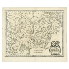
Antique Map of the Burgundy Region by Merian, 1646
Located in Langweer, NL
Antique map titled 'Utriusque Burgundiae tum Ducatus tum Comitatus descriptio'. Old map of the Burgundy region of France. This map originates from 'Neuwe Archontologia cosmica'. Arti...
Category
Antique 17th Century Maps
Materials
Paper
$179 Sale Price
20% Off
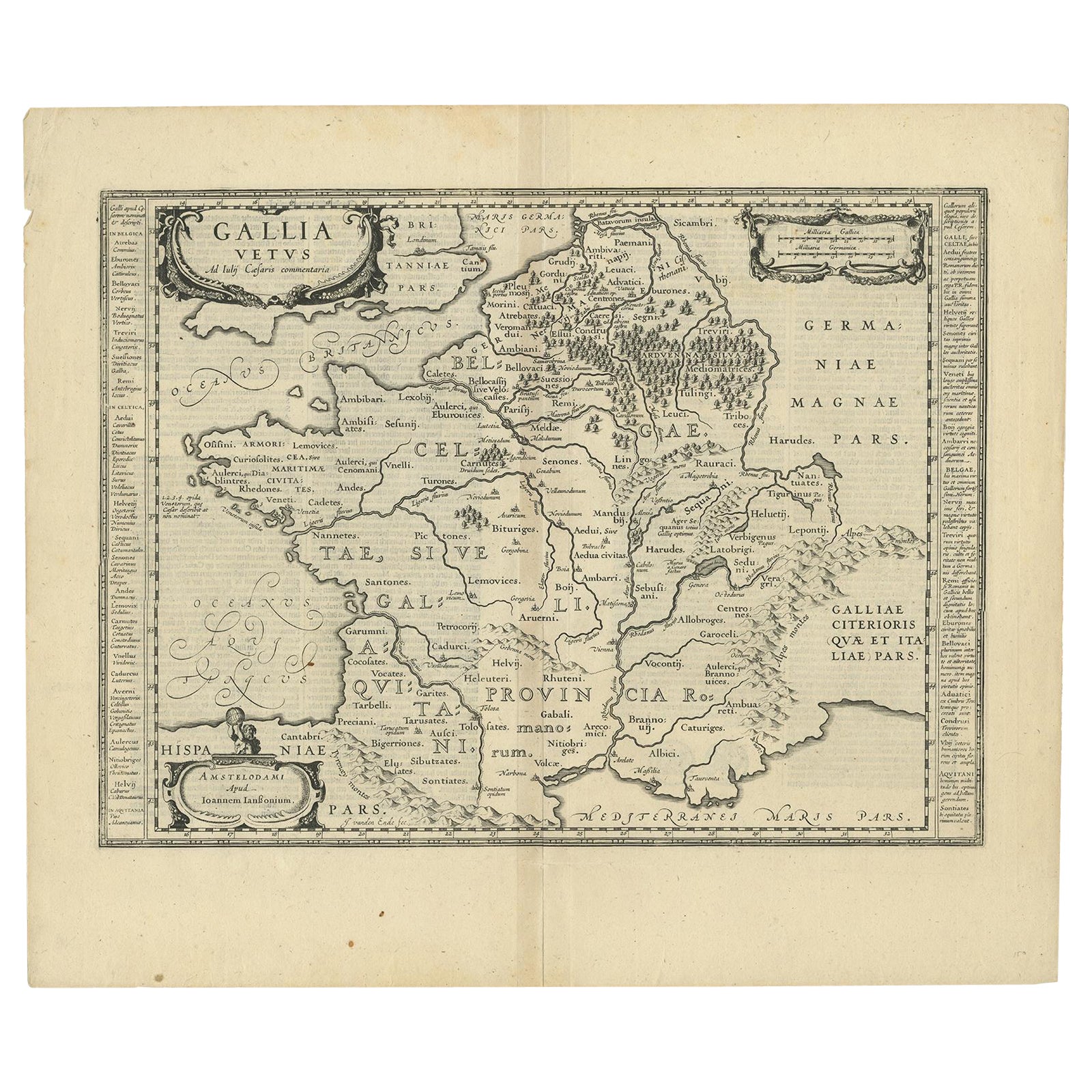
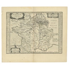
Antique Map of France by Janssonius, c.1650
Located in Langweer, NL
Antique map titled 'Gallia Vetus'. Beautiful map of France based on Caesar's De Bello Gallico. In the columns to the left and right important tribes and people are described.
Art...
Category
Antique 17th Century Maps
Materials
Paper
Antique Map of the Region of Périgord by Janssonius, 1657
By Johannes Janssonius
Located in Langweer, NL
Antique map of France titled 'Le Comte de Perigort'. Decorative map of the Périgord region. Périgord is a natural region and former province of France, which corresponds roughly to t...
Category
Antique 17th Century Maps
Materials
Paper

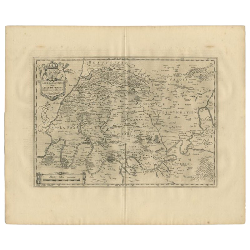
Antique Map of the Region of
Île de France
by Janssonius, 1657
By Johannes Janssonius
Located in Langweer, NL
Antique map of France titled 'Ager Parisiensis vulgo l'Isle de France'. Old map of Paris and adjacent regions. This map originates from 'Atlas Novus, ...
Category
Antique 17th Century Maps
Materials
Paper
You May Also Like
1640 Joan Bleau Map Entitled"Diocecese de rheims et le pais de rethel, " Eic.a011
Located in Norton, MA
1640 Joan Bleau map entitled
"Diocecese de rheims et le pais de rethel,"
Ric.a011
OAN BLAEU
Diocecese de Rheims, et le pais de Rethel.
Handcolored engraving, c.1640.
...
Category
Antique 17th Century Dutch Maps
Materials
Paper

1771 Bonne Map of Poitou, Touraine and Anjou, France, Ric.a015
Located in Norton, MA
1771 Bonne Map of Poitou,
Touraine and Anjou, France
Ric.a015
1771 Bonne map of Potiou, Touraine and Anjou entitled "Carte des Gouvernements D'Anjou et du Saumurois, de la Touraine, du Poitou,du Pays d'aunis, Saintonge?Angoumois,"
Carte des gouvernements d'Anjou et du Saumurois, de la Touraine, du Poitou, du Pays d'Aunis, Saintonge-Angoumois. Projettee et assujettie au ciel par M. Bonne, Hyd. du Roi. A Paris, Chez Lattre, rue St. Jacques a la Ville de Bord(ea)ux. Avec priv. du Roi. 1771. Arrivet inv. & sculp., Atlas moderne ou collection de cartes sur toutes...
Category
Antique 17th Century Unknown Maps
Materials
Paper

1656 Jansson Map Metz Region of France Entitled "Territorium Metense" Ric0014
Located in Norton, MA
1656 Jansson map Metz Region of France entitled "Territorium Metense."
Ric0014
" Authentic" - Map of the historical region surrounding Metz, in Lorraine, France.
Oriented with ...
Category
Antique 17th Century Dutch Maps
Materials
Paper

1714 Henri Chatelain "Nouvelle Carte Des Etatas Du Grand.Duc De Mos Moscovie Eur
Located in Norton, MA
A 1714 Henri Chatelain map, entitled
"Nouvelle Carte Des Etatas Du Grand Duc De Moscovie En Europe,"
Ricb001
Henri Abraham Chatelain (1684-1743) was a Huguenot pastor of Parisi...
Category
Antique Early 18th Century Dutch Maps
Materials
Paper

1597 Abraham Ortelius Map Burgundy, France Entitled "Bvrgvndiae dvcatvs Ric.a010
Located in Norton, MA
1597 Abraham Ortelius map of Burgundy, France entitled
"Bvrgvndiae dvcatvs
Ric.a010
Description: Ortelius is best known for producing the atla...
Category
Antique 16th Century Dutch Maps
Materials
Paper

1657 Janssonius Map of Vermandois and Cappelle, Ric. A-004
Located in Norton, MA
1657 Janssonius map of
Vermandois and Cappelle
Ric.a004
Description: Antique map of France titled 'Descriptio Veromanduorum - Gouvernement de la Cappelle'. Two detailed maps o...
Category
Antique 17th Century Unknown Maps
Materials
Paper

More Ways To Browse
Antique Map Burgundy
Antique Maps Singapore
Antique Planisphere
Map Of Palestine
R Johnston
Santa Cruz Island
Shetland Map
Antique Alabama Map
Antique Framed Map Engravings
Antique Furniture Cheshire
Antique Great Lakes Map
Antique Map Of Michigan
Antique Map Of Turkish Empire
Antique Map Of Yorkshire
Bali Map
Bermuda Map
British Empire Map
Caucasus Map