Items Similar to Antique Map of California as an Island "The 5 Californias" by Robert de Vaugondy


Want more images or videos?
Request additional images or videos from the seller
1 of 14
Antique Map of California as an Island "The 5 Californias" by Robert de Vaugondy
$850
£649.04
€738.96
CA$1,193.53
A$1,304.77
CHF 690.28
MX$15,613.63
NOK 8,782.82
SEK 8,039.79
DKK 5,519.57
About the Item
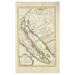
A very nice and rare antique map entitled "Carte de la Californie Suivant" (The 5 Californias), by Didier Robert de Vaugondy of Paris, circa 1772. The map itself measures 15.5" x 13" and is professionally presented in a nice brown wood frame with crimson mat; overall, the piece is 26" x 22". Overall, it is in good antique condition. #4395
This historically important depiction of the 5 most influential cartographic depictions of California, showing the evolution of how California was mapped between 1604 and 1767.
The earliest map is (upper right corner) based upon a manuscript map by Mathieu Neron Pecci, drawn in Florence in 1604. This map also forms the basis of a map popularized in 1770 by Rigobert Bonne.
The second map is Nicholas Sanson's map of California as an Island, based upon his larger map of 1656. This map was probably the single most influential projection of California as an Island.
The third map (lower right) is a portion of Guillaume De L'Isles map of America, published in 1700. While not truly peninsular in nature, it was influential in the shift back toward depicting California as a Peninsula.
The fourth map (upper center) is a portion of Fra. Eusebio Kino's map, generally credited with being the map which dispelled California as an Island myth. Issued in 1705, the map is based upon Father Kino's overland expedition from the mainland to the top of the Gulf of Cortez.
The fifth map is one of the most interesting and enduring maps of California and Baja (left side). Initially issued by the Society of Jesuits in 1767, it was popularized by Isaak Tirion and was perhaps the most interesting of all maps of Baja California in the 2nd half of the 18th century.
This map was 1 of 10 maps to appear in the Supplement to Diderot's monumental encyclopedia, one of the most influential and widely distributed works of the second half of the 18th century. Diderot's goal was to examine and display the popular geographical conceptions of several different parts of the world where the knowledge of the region's geography was still largely unknown and evolving. Other maps treat the Northwest Passage, Northeast Passage and the NW Coast of America, among other topics.
The popular misconception of California as an island can be found on European maps from the sixteenth through the eighteenth centuries. From its first portrayal on a printed map by Diego Gutiérrez, in 1562, California was shown as part of North America by mapmakers, including Gerardus Mercator and Abraham Ortelius. In the 1620s, however, it began to appear as an island in several sources. While most of these show the equivalent of the modern state of California separated from the continent, others, like a manuscript chart by Joao Teixeira Albernaz I (ca. 1632) now in the collection of the National Library of Brasil shows the entire western half of North America as an island.
The myth of California as an island was most likely the result of the travel account of Sebastian Vizcaino, who had been sent north up the shore of California in 1602. A Carmelite friar, Fray Antonio de la Ascensión, accompanied him. Ascension described the land as an island and around 1620 sketched maps to that effect. Normally, this information would have been reviewed and locked in the Spanish repository, the Casa de la Contratación. However, the manuscript maps were intercepted in the Atlantic by the Dutch, who took them to Amsterdam where they began to circulate. Ascensión also published descriptions of the insular geography in Juan Torquemada’s Monarquia Indiana (1613) (with the island details curtailed somewhat) and in his own Relación breve of ca. 1620.
A marvelous amalgam and an essential map for California collectors.!
- Dimensions:Height: 22 in (55.88 cm)Width: 26 in (66.04 cm)Depth: 1 in (2.54 cm)
- Materials and Techniques:
- Place of Origin:
- Period:
- Date of Manufacture:1772
- Condition:Wear consistent with age and use. Minor fading.
- Seller Location:San Diego, CA
- Reference Number:Seller: #43951stDibs: LU936644871742
About the Seller
4.9
Platinum Seller
Premium sellers with a 4.7+ rating and 24-hour response times
Established in 2000
1stDibs seller since 2012
4,451 sales on 1stDibs
Typical response time: <1 hour
- ShippingRetrieving quote...Shipping from: San Diego, CA
- Return Policy
More From This Seller
View AllHuge Europe and Asia Vintage Wall Map
Located in San Diego, CA
A huge Europe and Asia vintage wall map, circa 1950s. The map is in fair vintage condition and measures 78"W x 73"H". #2863
Category
Mid-20th Century American Maps
Materials
Paper
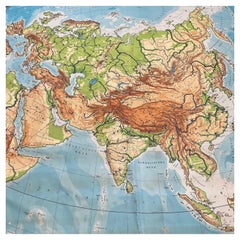
$380 Sale Price
20% Off
Antique Map of the Royal Botanic Garden
Arboretum Kew in London, England
Located in San Diego, CA
A very nice antique map of the Royal Botanic Garden & Arboretum in London, England, circa 1880s. The map itself measures 12" x 16" and is professionall...
Category
Antique Late 19th Century English Prints
Materials
Paper
$900 Sale Price
25% Off
Massive Vintage Wall Map of the Soviet Union
Sowjetunion
by Karl Wenschow
By Denoyer-Geppert
Located in San Diego, CA
A massive vintage wall map of the Soviet Union (Sowjetunion) published by Karl Wenschow in Munich, Germany, circa 1950s. The map was distributed by De...
Category
Mid-20th Century American Maps
Materials
Paper, Wood
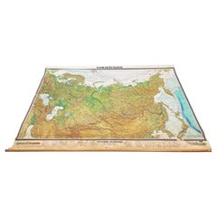
$540 Sale Price
20% Off
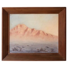
Joshua Tree Desert Landscape Painting 1960s
By John William Hilton
Located in San Diego, CA
Joshua Tree National Park desert landscape painting that captures the beauty and grandeur of this iconic park. Nice texture on board with th...
Category
Vintage 1960s American Mid-Century Modern Paintings
Materials
Wood, Paint
Antique Book Mark / Ruler Advertising, New York City
Located in San Diego, CA
An antique book mark / ruler advertising Jas. G. Wilson's blinds and shutter shop at 74 West 23rd Street in New York City, circa 1910s. The graphics ...
Category
Early 20th Century American More Desk Accessories
Materials
Bone
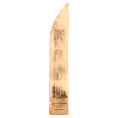
$340 Sale Price
20% Off
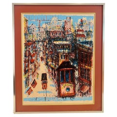
Signed Numbered Original Lithograph by Listed California Artist John West 90/100
Located in San Diego, CA
Colorful original litho by John West , circa 1970's titled California street , cable car from San Francisco numbered in Roman Numerals 90/100 signed by the artist with aluminium fram...
Category
20th Century American Mid-Century Modern Prints
Materials
Aluminum
You May Also Like
Original Antique Map of the American State of California ( Southern Part ), 1903
Located in St Annes, Lancashire
Antique map of California ( Southern part )
Published By A & C Black. 1903
Original colour
Good condition
Unframed.
Free shipping
Category
Antique Early 1900s English Maps
Materials
Paper

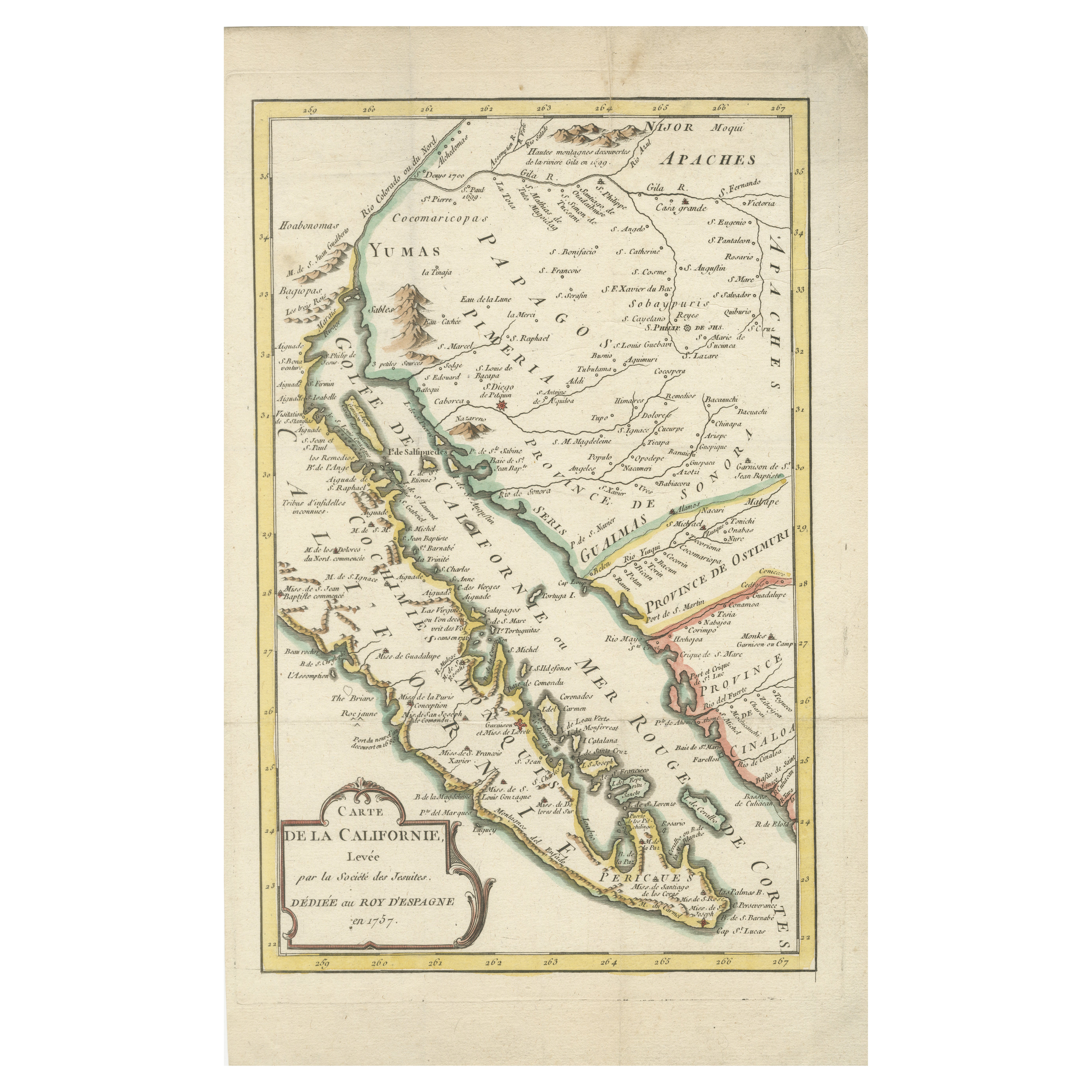
Rare 1757 Jesuit Map of California and Baja, Dedicated to the King of Spain
Located in Langweer, NL
Title: Rare 1757 Jesuit Map of California and Baja, Dedicated to the King of Spain
This rare and detailed map, titled *Carte de la Californie Levee par la Société des Jésuites*, wa...
Category
Antique 1750s Maps
Materials
Paper
Original Antique Map of the American State of California ( Northern Part ), 1903
Located in St Annes, Lancashire
Antique map of California ( Northern part )
Published By A & C Black. 1903
Original colour
Good condition
Unframed.
Free shipping
Category
Antique Early 1900s English Maps
Materials
Paper

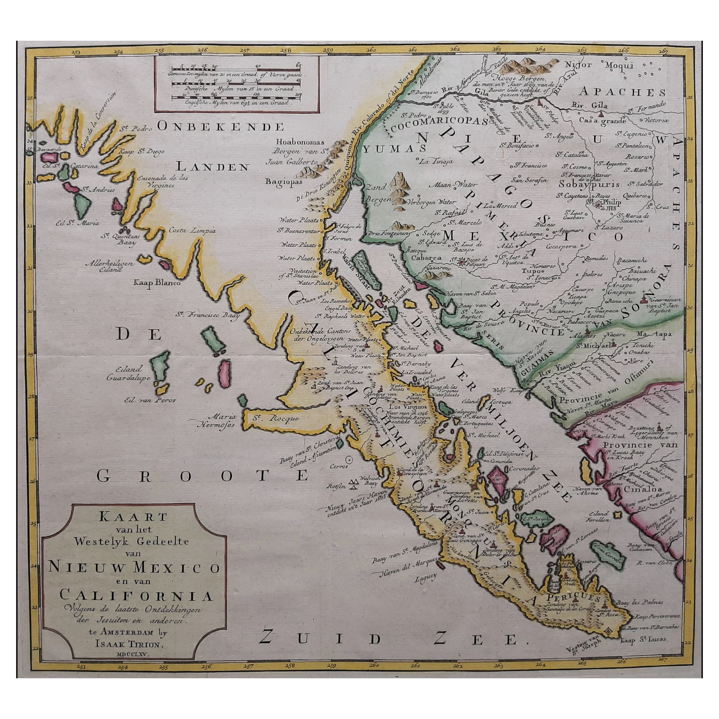
Original Antique Map of the Western Part of NEW MEXICO
CALIFORNIA
Located in Langweer, NL
Title: "Map of the Western Part of NEW MEXICO and CALIFORNIA According to the Latest Discoveries by the Jesuits and Others"
Description:
This exquisite original Dutch map, titled "...
Category
Antique 1760s Maps
Materials
Paper
$1,244 Sale Price
20% Off
Antique Map of North America by Dufour
circa 1834
Located in Langweer, NL
Antique map titled 'Amérique Septentrionale'. Uncommon map of North America. Published by or after A.H. Dufour, circa 1834. Source unknown, to be determined.
Category
Antique Mid-19th Century Maps
Materials
Paper

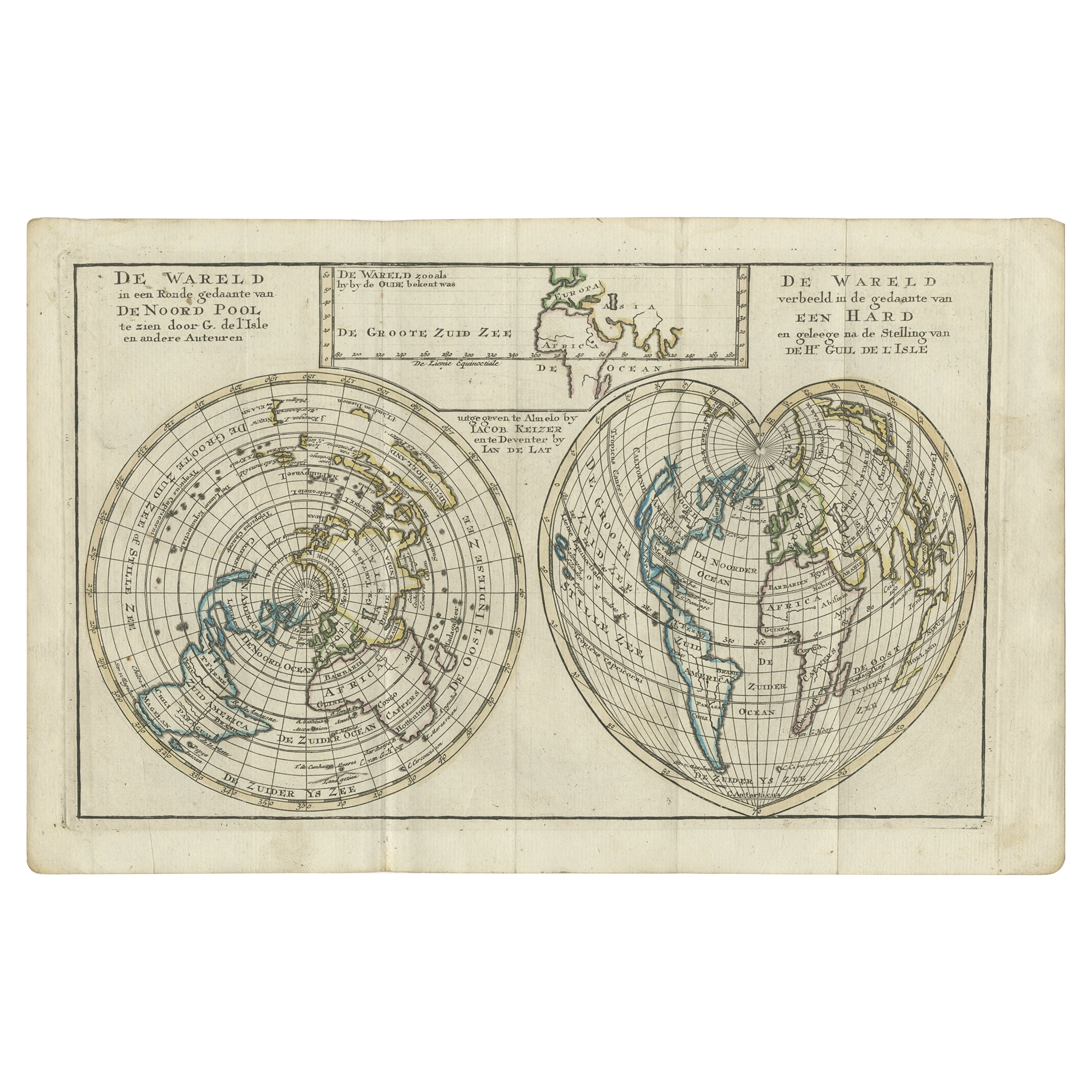
Antique Map of the World with California as an Island, 1788
Located in Langweer, NL
Description: Antique map titled 'De wareld in een ronde gedaante van de Noord Pool te zien - De Wareld verbeeld in de gedaante van een hard'. This interesting composition contains three world maps on the sheet. At left is a northern projection showing all the landmasses. At right is a cordiform projection (heart-shaped). At top is a map of the world as known to the ancients. Both the polar and cordiform projections show California as an island...
Category
Antique 1780s Maps
Materials
Paper

More Ways To Browse
Antique Manuscript
Antique Encyclopedias
Encyclopedia Antique
Antique Furniture California
Round Table Base
Cream Soup
Early English Silver
James Bond
Paisley Rugs and Carpets
Antique Pagoda
Black And Chrome Lounge Chair
Ceramic 1960s Italy
Vintage 1930 Dining Room Set
Antique Brass And Copper
Antique Cow
Antique Harvest
Antique Victorian Dining Tables
Environment Furniture