Want more images or videos?
Request additional images or videos from the seller
1 of 5
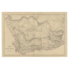
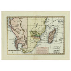
Antique Map of the Cape of Good Hope
Africa
by Albrizzi
1740
Price:$961.52
About the Item
- Dimensions:Height: 14.18 in (36 cm)Width: 19.69 in (50 cm)Depth: 0.02 in (0.5 mm)
- Materials and Techniques:
- Period:
- Date of Manufacture:1740
- Condition:Very good, given age. Edges on verso with remnants of acid free tape from former matting. A few spots in the margins. Original middle fold as issued. General age-related toning and/or occasional minor defects from handling. Please study images.
- Seller Location:Langweer, NL
- Reference Number:Seller: PCT-589511stDibs: LU3054321366912
About the Seller
5.0
Recognized Seller
These prestigious sellers are industry leaders and represent the highest echelon for item quality and design.
Platinum Seller
Premium sellers with a 4.7+ rating and 24-hour response times
Established in 2009
1stDibs seller since 2017
2,811 sales on 1stDibs
Typical response time: 1 hour
Authenticity Guarantee
In the unlikely event there’s an issue with an item’s authenticity, contact us within 1 year for a full refund. DetailsMoney-Back Guarantee
If your item is not as described, is damaged in transit, or does not arrive, contact us within 7 days for a full refund. Details24-Hour Cancellation
You have a 24-hour grace period in which to reconsider your purchase, with no questions asked.Vetted Professional Sellers
Our world-class sellers must adhere to strict standards for service and quality, maintaining the integrity of our listings.Price-Match Guarantee
If you find that a seller listed the same item for a lower price elsewhere, we’ll match it.Trusted Global Delivery
Our best-in-class carrier network provides specialized shipping options worldwide, including custom delivery.You May Also Like
Original Antique Map of South Africa, Arrowsmith, 1820
Located in St Annes, Lancashire
Great map of South Africa.
Drawn under the direction of Arrowsmith.
Copper-plate engraving.
Published by Longman, Hurst, Rees, Orme and Br...
Category
Antique 1820s English Maps
Materials
Paper

Original Antique Map of The World by Thomas Clerk, 1817
Located in St Annes, Lancashire
Great map of The Eastern and Western Hemispheres
On 2 sheets
Copper-plate engraving
Drawn and engraved by Thomas Clerk, Edinburgh.
Published by Mackenzie And Dent, 1817
...
Category
Antique 1810s English Maps
Materials
Paper

$90 / set
Free Shipping
H 10.25 in W 8.25 in D 0.07 in
Map of the Republic of Genoa
Located in New York, NY
Framed antique hand-coloured map of the Republic of Genoa including the duchies of Mantua, Modena, and Parma.
Europe, late 18th century.
Dimension: 25...
Category
Antique Late 18th Century European Maps

Antique Map of Principality of Monaco
By Antonio Vallardi Editore
Located in Alessandria, Piemonte
ST/619 - "Old Geographical Atlas of Italy - Topographic map of ex-Principality of Monaco" -
ediz Vallardi - Milano -
A somewhat special edition ---
Category
Antique Late 19th Century Italian Other Prints
Materials
Paper

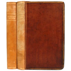
Voyage to the Cape of Good Hope, First Edition, c1785
Located in valatie, NY
Voyage to the Cape of Good Hope, towards the Antarctic polar circle, and round the world, but chiefly into the country of the Caffres, from the year ...
Category
Antique 18th Century Irish Books
Materials
Leather, Paper
"Africa Vetus": a 17th Century Hand-Colored Map by Sanson
By Nicolas Sanson
Located in Alamo, CA
This original hand-colored copperplate engraved map of Africa entitled "Africa Vetus, Nicolai Sanson Christianiss Galliar Regis Geographi" was originally created by Nicholas Sanson d...
Category
Antique Late 17th Century French Maps
Materials
Paper

$1,100 Sale Price
20% Off
H 18 in W 24 in D 0.13 in
Antique 18th Century Map of the Province of Pensilvania
Pennsylvania State
Located in Philadelphia, PA
A fine antique of the colony of Pennsylvania.
Noted at the top of the sheet as a 'Map of the province of Pensilvania'.
This undated and anonymous map is thought to be from the Gentleman's Magazine, London, circa 1775, although the general appearance could date it to the 1760's.
The southern boundary reflects the Mason-Dixon survey (1768), the western boundary is placed just west of Pittsburgh, and the northern boundary is not marked.
The map has a number of reference points that likely refer to companion text and appear to be connected to boundaries. The western and southern boundaries are marked Q, R, S, for example. A diagonal line runs from the Susquehanna R to the Lake Erie P. A broken line marked by many letters A, B, N, O, etc., appears in the east.
There are no latitude or longitude markings, blank verso.
Framed in a shaped contemporary gilt wooden frame and matted under a cream colored matte.
Bearing an old Graham Arader Gallery...
Category
Antique 18th Century British American Colonial Maps
Materials
Paper

$1,250
H 10.25 in W 13.25 in D 0.5 in
Map "Estuary- Mouth of the Thames"
Located in Alessandria, Piemonte
ST/426 - Antique French Map of the estuary of the Thames, map dated 1769 -
"Mape of the entrance of the Thames. Designed by filing of Navy cards fo...
Category
Antique Mid-18th Century French Other Prints
Materials
Paper

West Coast of Africa, Guinea
Sierra Leone: An 18th Century Map by Bellin
By Jacques-Nicolas Bellin
Located in Alamo, CA
Jacques Bellin's copper-plate map entitled "Partie de la Coste de Guinee Dupuis la Riviere de Sierra Leona Jusquau Cap das Palmas", depicting the coast of Guinea and Sierra Leone in ...
Category
Antique Mid-18th Century French Maps
Materials
Paper

$460 Sale Price
20% Off
H 10 in W 14.25 in D 0.07 in
Original Antique Map of Sweden, Engraved by Barlow, 1806
Located in St Annes, Lancashire
Great map of Sweden
Copper-plate engraving by Barlow
Published by Brightly & Kinnersly, Bungay, Suffolk. 1806
Unframed.
Category
Antique Early 1800s English Maps
Materials
Paper

More From This Seller
View AllAntique Map of the Cape of Good Hope by W. G. Blackie, 1859
Located in Langweer, NL
Antique map titled 'Cape of Good Hope'. Original antique map of the Cape of Good Hope. This map originates from ‘The Imperial Atlas of Modern Geography’. Published by W. G. Blackie, ...
Category
Antique Mid-19th Century English Maps
Materials
Paper
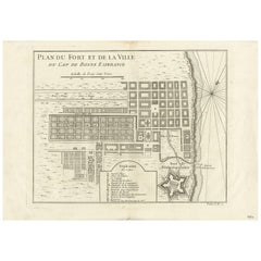
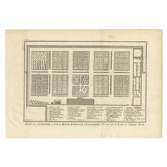
Antique Map of the Cape of Good Hope by J.N. Bellin, 1748
Located in Langweer, NL
Early plan of the Cape of Good Hope, includng a town plan and illustrations of the fortificatons. This map originates from Tome V of Abbe Prevost's Histoire generale du voyages.
Category
Antique Mid-18th Century Maps
Materials
Paper
Dutch Antique Map of the West Coast of Africa, to the Cape of Good Hope, 1747
Located in Langweer, NL
Antique map of the Coast of Africa titled 'Kaart van de West Kust van Afrika (..)'.
Map of the west coast of Africa, from 11 degrees south latitude to the Cape of Good Hope. This...
Category
Antique 1740s Maps
Materials
Paper
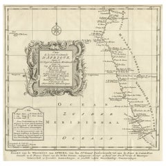
$374 Sale Price
20% Off
Free Shipping
Antique Map of Mozambique and Cape of Good Hope with Kingdom Monomotapa, 1780
Located in Langweer, NL
Antique map titled 'Carte Du Canal De Mozambique.' The main map, on the right, covers from the Cape of Good Hope north as far as Zanzibar and modern day Kenya, focusing on the gold r...
Category
Antique 18th Century Maps
Materials
Paper
Antique Print of the Gardens at Cape of Good Hope by Van Schley, 1756
Located in Langweer, NL
Antique print titled 'Jardin de la Compagnie au Cap de Bonne Esperance, Compagnies Tuyn aan de Kaap de Goede Hoop'. This print depicts the Gardens at Cape of Good Hope (VOC). This pr...
Category
Antique 18th Century Prints
Materials
Paper
$158 Sale Price
20% Off
Antique Map of the Cape Verde Islands, Africa, ca.1670
Located in Langweer, NL
Antique map titled 'Pascaert van de Soute Eylanden ofte Ilhas de Cabo Verde'.
This map depicts the Cape Verde Islands (Africa). Islands titled 'Ile de B...
Category
Antique 1670s Maps
Materials
Paper
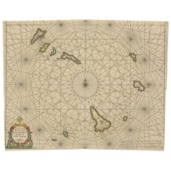
$634 Sale Price
20% Off