Items Similar to Antique Map: Carte du Détroit du Sond with Copenhagen Inset, 1693


Want more images or videos?
Request additional images or videos from the seller
1 of 8
Antique Map: Carte du Détroit du Sond with Copenhagen Inset, 1693
$2,161.61
$2,702.0220% Off
£1,601
£2,001.2520% Off
€1,800
€2,25020% Off
CA$2,956.98
CA$3,696.2320% Off
A$3,218.10
A$4,022.6320% Off
CHF 1,705.91
CHF 2,132.3920% Off
MX$38,716.25
MX$48,395.3120% Off
NOK 21,636.47
NOK 27,045.5820% Off
SEK 19,795.85
SEK 24,744.8220% Off
DKK 13,716.31
DKK 17,145.3920% Off
About the Item
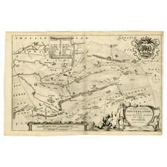
Antique Map: Carte du Détroit du Sond with Copenhagen Inset, Jaillot/Mortier, 1693
This rare and striking antique map, titled *Carte du détroit du Sond contenant les costes de l’Isle de Zelande*, is a beautifully engraved and detailed coastal map of the Strait of Øresund, depicting the waterways and coasts between Zealand (Denmark) and Scania (Sweden). Published in Amsterdam by Pieter Mortier in 1693, it forms part of *La Neptune François*, an influential collection of sea charts commissioned under the guidance of Colbert, minister to Louis XIV of France.
This map offers a meticulous depiction of the Øresund Strait, a critical maritime passage linking the North and Baltic Seas. Its inset map, *Carte de la Rade de Copenhague et des Environs*, highlights Copenhagen and its surroundings, adding depth to this chart’s practical and aesthetic appeal. The map is enriched by finely engraved cartouches and navigational details, characteristic of Alexis-Hubert Jaillot's collaboration with Mortier.
Jaillot, a prominent French cartographer, inherited and expanded upon the works of Nicolas Sanson, the leading cartographer of his time. Jaillot's ability to combine Sanson’s precision with large-scale, decorative maps made his work highly sought after. This particular map exemplifies Jaillot’s and Mortier’s dedication to accuracy, elegance, and maritime utility.
Keywords: antique map Øresund Strait, Jaillot/Mortier sea chart, Zealand and Scania map, 17th-century nautical map, Copenhagen inset map, La Neptune François map, maritime cartography, Pieter Mortier, Alexis-Hubert Jaillot, decorative French sea charts, rare antique maps, Baltic Sea navigation, Covens and Mortier publishing.
This piece is perfect for collectors of rare antique maps, maritime history enthusiasts, or anyone seeking a stunning historical artifact for display. Its connection to influential cartographers and publishers, combined with its focus on one of Europe’s most important waterways, ensures its value as both an artwork and a piece of history.
- Dimensions:Height: 25.79 in (65.5 cm)Width: 37.01 in (94 cm)Depth: 0.02 in (0.5 mm)
- Materials and Techniques:
- Period:Late 17th Century
- Date of Manufacture:1693
- Condition:Condition: good, given age. some foxing, soilng and creasing. General age-related toning and/or occasional minor defects from handling. Please study scan carefully.
- Seller Location:Langweer, NL
- Reference Number:Seller: BG-004051stDibs: LU305438911823
About the Seller
5.0
Recognized Seller
These prestigious sellers are industry leaders and represent the highest echelon for item quality and design.
Platinum Seller
Premium sellers with a 4.7+ rating and 24-hour response times
Established in 2009
1stDibs seller since 2017
2,813 sales on 1stDibs
Typical response time: 1 hour
- ShippingRetrieving quote...Shipping from: Langweer, Netherlands
- Return Policy
More From This Seller
View AllAntique Map Dedicated to British Merchants Trading to North America, ca.1746
Located in Langweer, NL
Description: Antique map titled 'A New Chart of the Coast of New England, Nova Scotia, New France or Canada, with the islands of Newfoundland, Capte Breton, St John's (..)'. Map stre...
Category
Antique 1740s Maps
Materials
Paper
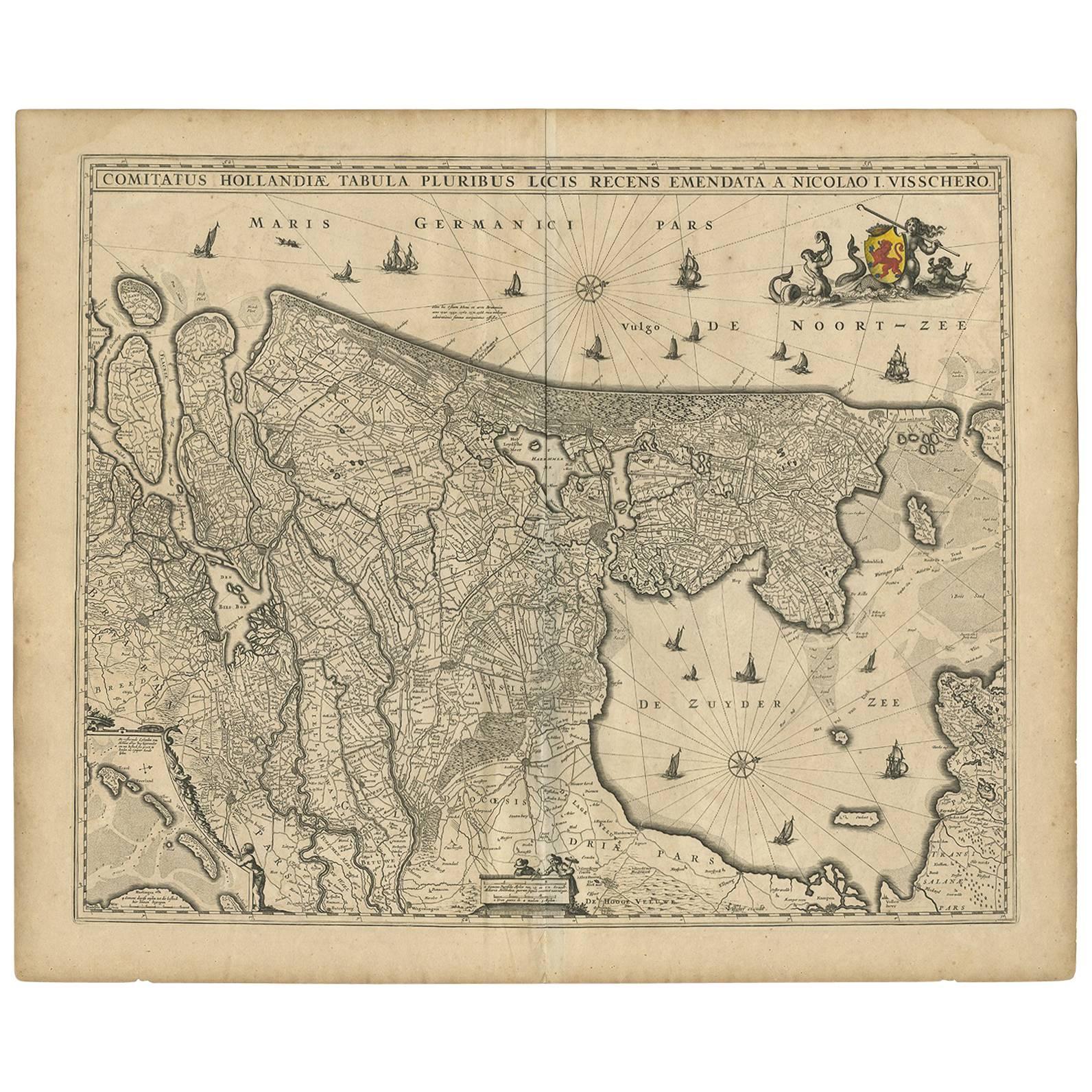
Antique Map of the Netherlands by N. Visscher, 1684
Located in Langweer, NL
Antique map titled 'Comitatus Hollandiae Tabula Pluribus Locis Recens Emendata a Nicolao I. Visschero'. West to the top. Lower left inset of the Wadden Islands, Texel, Vlieland, Ters...
Category
Antique Late 17th Century Maps
Materials
Paper

$1,056 Sale Price
20% Off
Antique Map of Denmark with Details of Fortresses, Cities, Towns Etc, c.1680
Located in Langweer, NL
Antique map of Denmark titled 'Insularum Danicarum ut Zee-Landiae, Fioniae, Langelandiae, Lalandiae Falstriae, Fembriae, Monae (..)'. This map depicts the main Danish Islands and a s...
Category
Antique 17th Century Maps
Materials
Paper

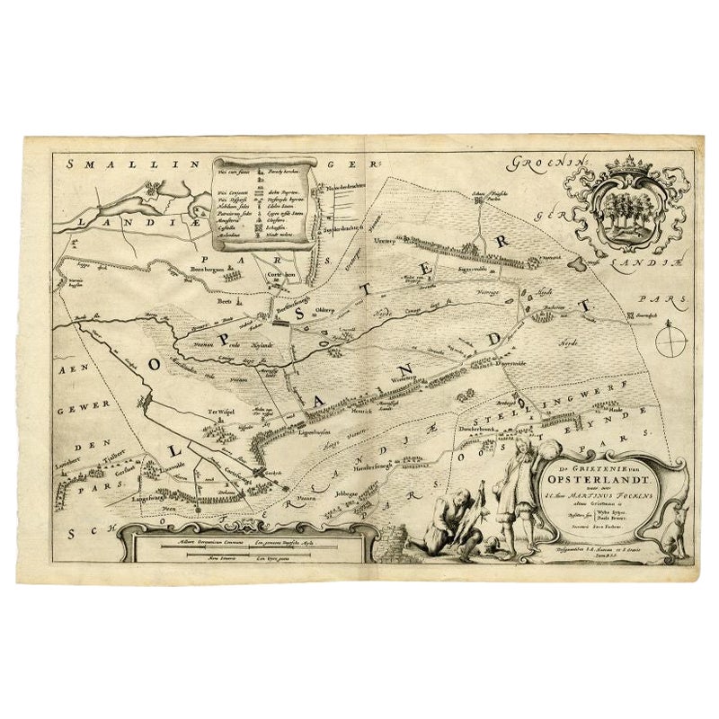
Antique Map of the Region of Opsterland by Schotanus, 1664
By B. Schotanus
Located in Langweer, NL
Antique map titled 'De Grietenie van Opsterlandt : waer over d'e. heer Martinus Fockens altans grietman is, bysitters syn Wybe Sytjes, Boele Broers, secretaris Saco Fockens.' Detaile...
Category
Antique 17th Century Maps
Materials
Paper
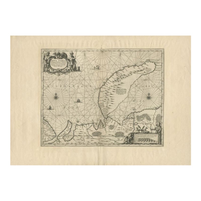
Antique Map of Nova Zembla by Janssonius, c.1650
Located in Langweer, NL
Antique map titled 'Nova Zemla, waygats fretum Nassovi cum et terra Samoiedum singula omnium emendatissime descripta'. This map depicts Nova Zembla and the northern continental coast...
Category
Antique 17th Century Maps
Materials
Paper

$381 Sale Price
20% Off
Map of Denmark Divided into Dioceses – G.
L. Valk, ca. 1690
Located in Langweer, NL
Map of Denmark Divided into Dioceses – G. & L. Valk, ca. 1700
Detailed antique map titled "Regnum Daniae, divisum in Dioeceses Arhusiam, Albergum, Viborgum, et Ripam," showing Denma...
Category
Antique Late 17th Century Maps
Materials
Paper

$528 Sale Price
20% Off
You May Also Like
1646 Jansson Map Entitled "Procinvia Connactiae, " Ric.a006
Located in Norton, MA
1646 Jansson map entitled
"Procinvia connactiae,"
Ric.a006
Description: The PROVINCE of CONNAVGT 490 x 380From vol 4 of Jansson's Atlas Novus 1646, published in Amsterdam with...
Category
Antique 17th Century Unknown Maps
Materials
Paper

1654 Joan Blaeu Map the Sutherland, Scotland, Entitled "Southerlandia, "Ric0007
Located in Norton, MA
1654 Joan Blaeu map of the
Sutherland, Scotland, entitled
"Southerlandia,"
Hand Colored
Ric0007
Description:
Lovely map centered on Sedan and D...
Category
Antique 17th Century Dutch Maps
Materials
Paper

1633 Map "La Souverainete De Sedan Et De Raucourt, Et La Prevoste Ric0011
Located in Norton, MA
1653 map entitled
"La Souverainete de Sedan et de Raucourt, et la Prevoste de Doncheri,"
Ric0011
Description:
Lovely map centered on Sedan and Doncheri and the Meuze River fr...
Category
Antique 17th Century Dutch Maps
Materials
Paper

Rare Original Map of New Amsterdam (New York) – “Restitutio”, ca. 1674 –
Located in Dronten, NL
An exceptionally rare and original 17th-century engraving of New Amsterdam, now New York City, published by the renowned Amsterdam cartographer Carel (Carolus) Allard around 1674. Kn...
Category
Antique 17th Century Dutch Maps
Materials
Paper

1627 Hendrik Hondius Map Entitled "Vltoniae Orientalis Pars, " Ric.a009
Located in Norton, MA
1627 Hendrik Hondius map entitled
"Vltoniae orientalis pars,"
Ric.a009
Title:
Vltoniae orientalis : pars
Title (alt.) :
Ultoniae orientalis pars
Creator:
Mercator, Gerh...
Category
Antique 17th Century Dutch Maps
Materials
Paper

17th Century Map of Denmark by French Cartographer Sanson, Dated 1658
By Nicolas Sanson
Located in Copenhagen, K
17th century map of Denmark by French cartographer Sanson.
Nicolas Sanson (20 December 1600-7 July 1667) was a French cartographer, termed by some the creator of French geography an...
Category
Antique 17th Century French Maps
Materials
Paper

More Ways To Browse
Detroit Furniture
Antique Furniture Detroit
Antique Russian Rugs
For Kids
Sterling Silver Flatware Set Service For 12
Tufted Bar
Pair Of French Antique Armchairs
1970s Brass Glass Coffee Table
Charles Rennie Mackintosh For Cassina
Glass Salt
Italian Modern Silver Vases
Vintage Resin Tables
Antique English Country Furniture
Blue Kilim Vintage
Contemporary Side Tables And Stools
Decorative Wall Plate
Mid Century Modern Corner Chair
Dining Tables With Brass Inlay