Items Similar to Antique Map of Celebes and the Maluku Islands by W. G. Blackie, 1859

Want more images or videos?
Request additional images or videos from the seller
1 of 6
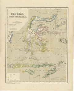
Antique Map of Celebes and the Maluku Islands by W. G. Blackie, 1859
$191.65
$239.5720% Off
£143.31
£179.1420% Off
€160
€20020% Off
CA$264.05
CA$330.0620% Off
A$287.98
A$359.9820% Off
CHF 152.55
CHF 190.6920% Off
MX$3,452.53
MX$4,315.6620% Off
NOK 1,942.87
NOK 2,428.5920% Off
SEK 1,776.61
SEK 2,220.7720% Off
DKK 1,219.26
DKK 1,524.0820% Off
About the Item
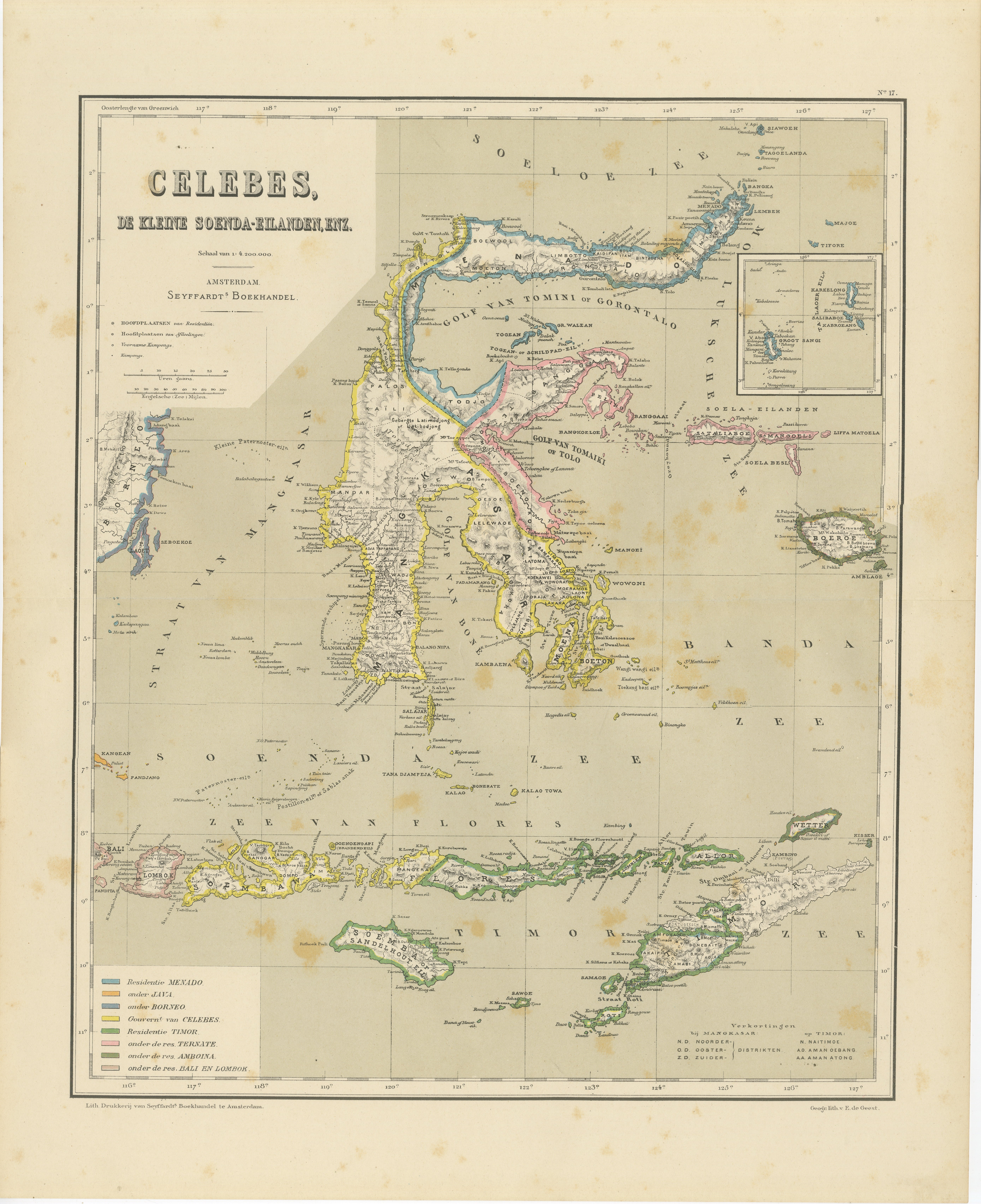
Antique map titled 'Celebes and The Molucca Islands '. Original antique map of Celebes and the Maluku Islands (Moluccas). This map originates from ‘The Imperial Atlas of Modern Geography’. Published by W. G. Blackie, 1859.
- Dimensions:Height: 10.63 in (27 cm)Width: 14.57 in (37 cm)Depth: 0.02 in (0.5 mm)
- Materials and Techniques:
- Period:
- Date of Manufacture:1859
- Condition:Wear consistent with age and use. General age-related toning. some foxing, Please study image carefully.
- Seller Location:Langweer, NL
- Reference Number:Seller: BG-12685-1-571stDibs: LU3054325242282
About the Seller
5.0
Recognized Seller
These prestigious sellers are industry leaders and represent the highest echelon for item quality and design.
Platinum Seller
Premium sellers with a 4.7+ rating and 24-hour response times
Established in 2009
1stDibs seller since 2017
2,788 sales on 1stDibs
Typical response time: <1 hour
- ShippingRetrieving quote...Shipping from: Langweer, Netherlands
- Return Policy
More From This Seller
View AllAntique Colonial Map of Celebes Sulawesi
Lesser Sunda Islands, 1884
Located in Langweer, NL
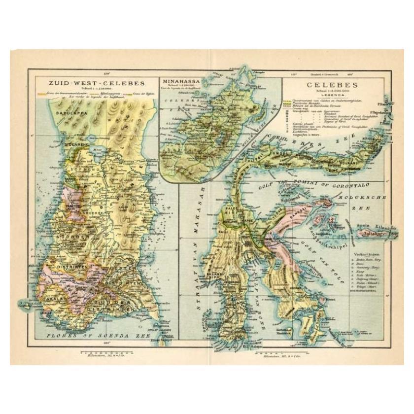
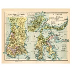
Antique Colonial Map of Celebes Sulawesi & Lesser Sunda Islands 19th C
This beautiful and highly detailed antique map depicts the island of Celebes (modern-day Sulawesi) together wi...
Category
Antique 1880s Dutch Maps
Materials
Paper
Antique Map of Sulawesi by Winkler Prins, c.1900
Located in Langweer, NL
Antique map titled 'Celebes.' (Sulawesi .) This map shows the Indonesian island of Sulawesi, one of the Sunda islands. With inset maps of South-west Sulawesi and Semenanjung Minahassa. Legend and scale. This map originates from 'De Grote Winkler Prins...
Category
20th Century Maps
Materials
Paper
$69 Sale Price
20% Off
Antique Colonial Dutch Map of the Moluccas
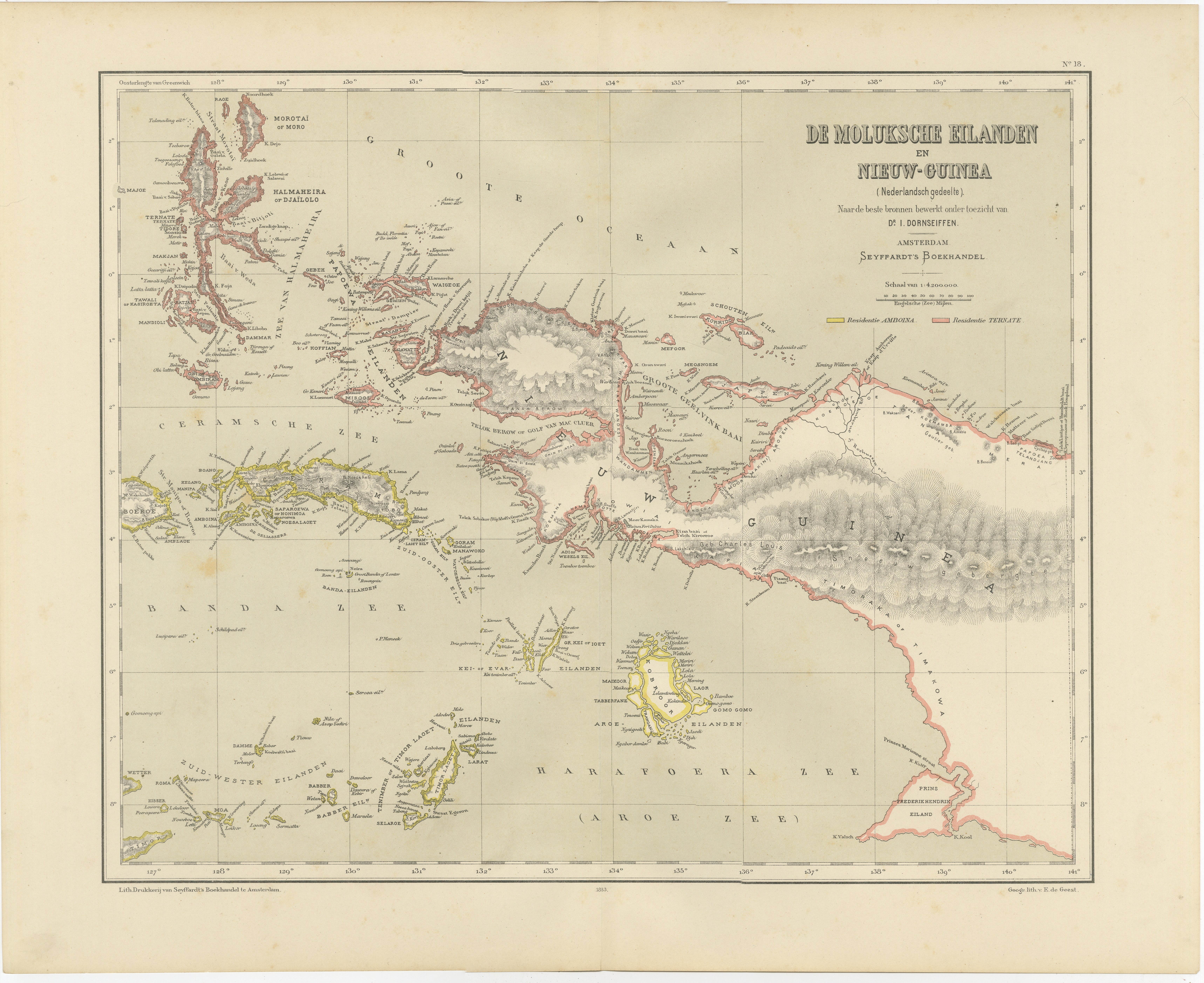
New Guinea by Dornseiffen, 1884
Located in Langweer, NL
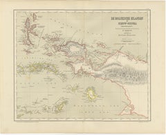
Antique Dutch Map of the Moluccas & New Guinea by Dornseiffen 1884 Indonesia
This decorative antique map depicts the Moluccan Islands (Spice Islands) and the western portion of New ...
Category
Antique 1880s Dutch Maps
Materials
Paper
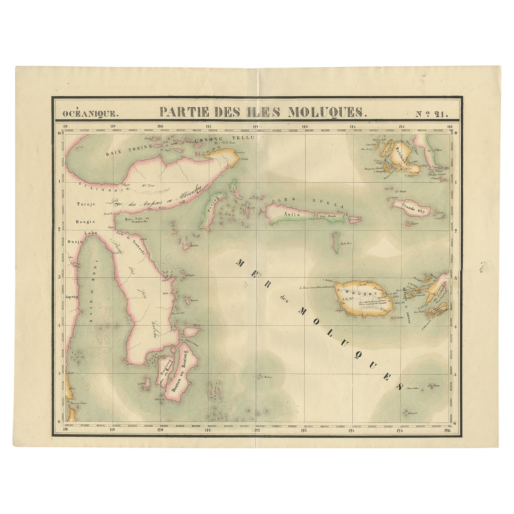
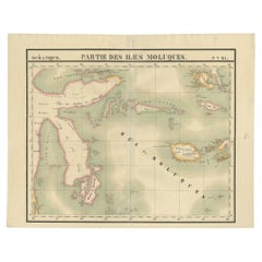
Old Map of the Moluccas and Part of Sulawesi Indonesia by Vandermaelen, c 1825
Located in Langweer, NL
Antique map titled 'Partie des Iles Moluques'. Map of a portion of the Moluccas and part of Sulawesi. Includes the Maluku islands Buru, Sula, Bacan and more. Originates from 'Atlas U...
Category
Antique 19th Century Maps
Materials
Paper
$603 Sale Price
20% Off
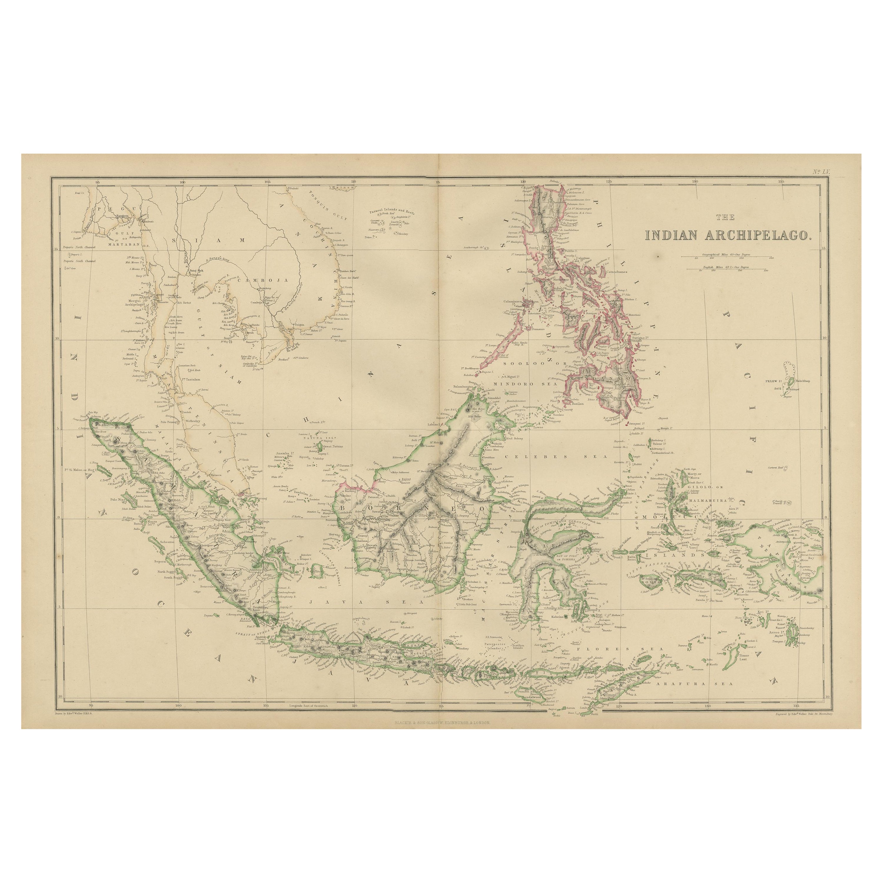
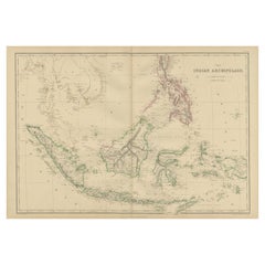
Antique Map of the East Indies by W. G. Blackie, 1859
Located in Langweer, NL
Antique map titled 'The Indian Archipelago'. Original antique map of the East Indies. This map originates from ‘The Imperial Atlas of Modern Geography’. Published by W. G. Blackie, 1...
Category
Antique Mid-19th Century Maps
Materials
Paper
$263 Sale Price
20% Off
Antique Map of the Moluccas by Stemfoort, 1885
Located in Langweer, NL
Antique map titled 'Kaart der Molukken'. Old map of the southern tip of the Moluccas, or Maluku Islands. With an inset map of part of Ambon Island and an inset map of New Guinea. Thi...
Category
Antique 19th Century Dutch Maps
Materials
Paper

You May Also Like
Large Original Antique Map of Java and Borneo, Fullarton, C.1870
Located in St Annes, Lancashire
Great map of Java and Borneo
Wonderful figurative borders
From the celebrated Royal Illustrated Atlas
Lithograph. Original color.
Published by Fullarton, Edinburgh. C.1870
Unfr...
Category
Antique 1870s Scottish Maps
Materials
Paper

Large Original Vintage Map of The Pacific Islands Including Hawaii
Located in St Annes, Lancashire
Great map of The Pacific Islands
Unframed
Original color
By John Bartholomew and Co. Edinburgh Geographical Institute
Published, circa 1...
Category
Vintage 1920s British Maps
Materials
Paper

Original Antique Map of South East Asia by Thomas Clerk, 1817
Located in St Annes, Lancashire
Great map of South East Asia
Copper-plate engraving
Drawn and engraved by Thomas Clerk, Edinburgh.
Published by Mackenzie And Dent, 1817
Unframed.
Category
Antique 1810s English Maps
Materials
Paper

Original Antique Map of US Possessions In The Pacific Ocean, C.1900
Located in St Annes, Lancashire
Fabulous map of US possessions in the Pacific Ocean
Original color.
Engraved and printed by the George F. Cram Company, Indianapolis.
Published, C.1900.
Unframed.
Free shipping.
Category
Antique 1890s American Maps
Materials
Paper

Large Original Antique Map of The Greek Islands. 1894
Located in St Annes, Lancashire
Superb Antique map of The Greek Islands
Published Edward Stanford, Charing Cross, London 1894
Original colour
Good condition
Unframed.
Free shipping
Category
Antique 1890s English Maps
Materials
Paper

Large Original Antique Map of The Leeward Islands. 1894
Located in St Annes, Lancashire
Superb Antique map of The Leeward Islands
Published Edward Stanford, Charing Cross, London 1894
Original colour
Good condition
Unframed.
Free shipping
Category
Antique 1890s English Maps
Materials
Paper

More Ways To Browse
Map Of Egypt
Antique Ecuador
Antique Map New York
Nautical Maps
18th Century Maps America
Antique Map Of Egypt
Map Of Austria
New Zealand Map
Antique Linen Map
19th Century World Map
Antique Ohio Maps
Antique Texas Furniture
Military Map
Antique Maps New Zealand
Birds Eye View Map
North Africa Map
West Africa Map
Antique Compass Map