Items Similar to Antique Map of Central America and the West Indies, 1882


Want more images or videos?
Request additional images or videos from the seller
1 of 5
Antique Map of Central America and the West Indies, 1882
$215.40
£160.88
€180
CA$296.75
A$323.40
CHF 171.26
MX$3,884.40
NOK 2,168.13
SEK 1,993.38
DKK 1,371.29
About the Item
Antique map titled 'West India Islands and Central America'. Old map of Central America and the West Indies. This map originates from 'The Royal Atlas of Modern Geography, Exhibiting, in a Series of Entirely Original and Authentic Maps, the Present Condition of Geographical Discovery and Research in the Several Countries, Empires, and States of the World' by A.K. Johnston. Published by W. and A.K. Johnston, 1882.
Artists and engravers: Alexander Keith Johnston LLD (1804-1871) was a Scottish geographer. He was a pupil of the Edinburgh engraver and mapmaker, James Kirkwood. In 1826, he joined his brother William (who would become Sir William Johnston, Lord Provost of Edinburgh) in a printing and engraving business, forming the well-known cartographical firm of W. and A. K. Johnston.
Condition: Good, general age-related toning. Please study image carefully.
Date: 1882
Overall size: 61.3 x 49.6 cm.
Image size: 57.4 x 44.3 cm.
- Dimensions:Height: 19.53 in (49.6 cm)Width: 24.14 in (61.3 cm)Depth: 0 in (0.01 mm)
- Materials and Techniques:
- Period:
- Date of Manufacture:1882
- Condition:
- Seller Location:Langweer, NL
- Reference Number:Seller: BG-11823-481stDibs: LU3054326084192
About the Seller
5.0
Recognized Seller
These prestigious sellers are industry leaders and represent the highest echelon for item quality and design.
Platinum Seller
Premium sellers with a 4.7+ rating and 24-hour response times
Established in 2009
1stDibs seller since 2017
2,788 sales on 1stDibs
Typical response time: <1 hour
- ShippingRetrieving quote...Shipping from: Langweer, Netherlands
- Return Policy
More From This Seller
View AllAntique Map of the Antilles in the Caribbean,
1875
Located in Langweer, NL
Antique map titled 'Carte des Iles Antilles'. Large map of the Antilles. This map originates from 'Atlas de Géographie Moderne Physique et Politique' by A. Levasseur. Published, 1875.
Category
Antique Late 19th Century French Maps
Materials
Paper

$329 Sale Price
44% Off
Antique Map of the Antilles and Central America – 1872
Located in Langweer, NL
Title: Antique Map of the Antilles and Central America – 1872
Description:
This finely detailed antique map, titled Antilles et Amérique Centrale, was published in 1872 under t...
Category
Antique 1870s Maps
Materials
Paper

Antique Map of the West Indies and Central America by W. G. Blackie, 1859
Located in Langweer, NL
Antique map titled 'The West India Island & Central America'. Original antique map of the West Indies and Central America, with inset map of Jamaica. Th...
Category
Antique Mid-19th Century Maps
Materials
Paper

$239 Sale Price
20% Off
Antique Map of the West Indies and Central America by Lowry
1852
Located in Langweer, NL
Antique map titled 'West Indies and Central America'. Original map of the West Indies and Central America. This map originates from 'Lowry's Table Atlas constructed and engraved from...
Category
Antique Mid-19th Century Maps
Materials
Paper

$95 Sale Price
20% Off
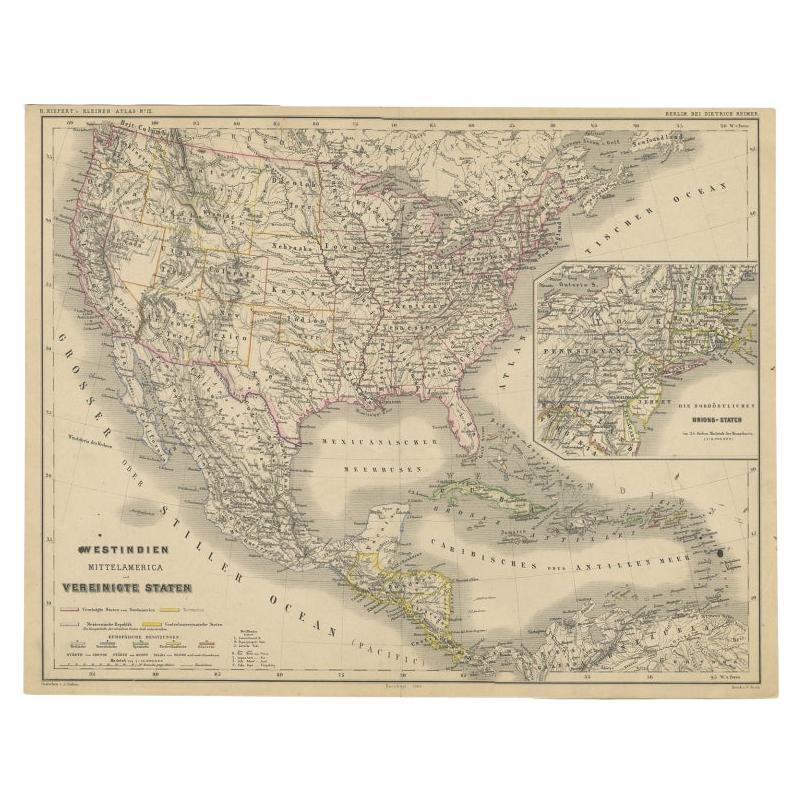
Old German Map of the United States, Central America and the West Indies, c.1870
Located in Langweer, NL
Antique map titled 'Westindien, Mittelamerica und Vereinigte Staten'. Old map of the United States, Central America and the West Indies. This map originates from 'H. Kiepert's Kleine...
Category
Antique 19th Century Maps
Materials
Paper
Antique Map of Mexico, Central America and West Indies by A
C. Black, 1870
Located in Langweer, NL
Antique map titled 'Mexico, Central America and West Indies'. Original antique map of Mexico, Central America and West Indies with inset map of Panama railway. This map originates fr...
Category
Antique Late 19th Century Maps
Materials
Paper

$167 Sale Price
20% Off
You May Also Like
Large Original Antique Map of The West Indies by Sidney Hall, 1847
Located in St Annes, Lancashire
Great map of The West Indies
Drawn and engraved by Sidney Hall
Steel engraving
Original colour outline
Published by A & C Black. 1847
Unframed
Free shipping.
Category
Antique 1840s Scottish Maps
Materials
Paper

Original Antique Map of Central America / Florida, Arrowsmith, 1820
Located in St Annes, Lancashire
Great map of Central America.
Drawn under the direction of Arrowsmith.
Copper-plate engraving.
Published by Longman, Hurst, Rees, Orme and Brown, 1820
Unframed.
Category
Antique 1820s English Maps
Materials
Paper

Large Original Antique Map of The Leeward Islands. 1894
Located in St Annes, Lancashire
Superb Antique map of The Leeward Islands
Published Edward Stanford, Charing Cross, London 1894
Original colour
Good condition
Unframed.
Free shipping
Category
Antique 1890s English Maps
Materials
Paper

Central America. Century Atlas antique vintage map
Located in Melbourne, Victoria
'The Century Atlas. Central America.'
Original antique map, 1903.
Inset maps of 'The Country around Lake Nicaragua'.
Central fold as issued. Map name and number printed on the reve...
Category
Early 20th Century Victorian More Prints
Materials
Lithograph

Original Antique Map of The Western Hemisphere by Dower, circa 1835
Located in St Annes, Lancashire
Nice map of the Western Hemisphere
Drawn and engraved by J.Dower
Published by Orr & Smith. C.1835
Unframed.
Free shipping
Category
Antique 1830s English Maps
Materials
Paper

Large Original Antique Map of the The Windward Islands. 1894
Located in St Annes, Lancashire
Superb Antique map of The Windward Islands
Published Edward Stanford, Charing Cross, London 1894
Original colour
Good condition
Unframed.
Free shipping
Category
Antique 1890s English Maps
Materials
Paper

More Ways To Browse
Antique Maps West Indies
American West Antiques
Biblical Maps
Maps Of Mediterranean
Treasure Map
Antique Navigational Tools
Mississippi Furniture
Caribbean Antiques
Antique Maps West Indies
Antique Mozambique
Malaysian Antique Furniture
Relief Map
Sur Tout
Antique Civil War Maps
Antique Nautical Maps
Civil War Map
Royal Stuart
Sri Lanka Map