Items Similar to Antique Map of China, Japan
Korea – Eastern Asia by Andriveau-Goujon, 1860


Want more images or videos?
Request additional images or videos from the seller
1 of 10
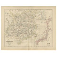
Antique Map of China, Japan
Korea – Eastern Asia by Andriveau-Goujon, 1860
$462.76
£345.47
€390
CA$642.91
A$691.54
CHF 369.58
MX$8,151.30
NOK 4,659.53
SEK 4,259.70
DKK 2,972.24
About the Item
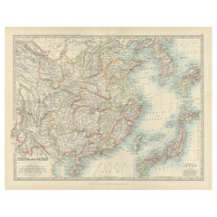
Antique Map of China, Japan
Korea – Eastern Asia by Andriveau-Goujon, 1860
This beautifully hand-colored antique map, titled “Carte de la Chine, de la Corée et du Japon,” was published in Paris in 1860 by E. Andriveau-Goujon as plate number 36 in his Atlas Universel. It offers a highly detailed view of Eastern Asia at a time of dramatic change, with sharp delineations of the Qing Empire, the expanding Russian Empire, and newly opening trade routes to Japan and Korea.
China is prominently featured at the center, divided into its various imperial provinces. Major cities such as Beijing (Pekin), Nanking, Canton (Guangzhou), and Shanghai are clearly marked, alongside key geographical features like the Yellow River, Yangtze River, and the Great Wall. The western parts of the empire, including Xinjiang and Tibet, are also well represented.
To the east, the Korean Peninsula is shown as a vassal kingdom under Chinese suzerainty. Japan, still under the Tokugawa Shogunate at the time, is depicted in its entirety, with the main islands of Honshu, Kyushu, Shikoku, and Hokkaido carefully labeled and outlined. This was just years after Commodore Perry’s expedition opened Japan to foreign trade in 1854, marking this map as a historical document of geopolitical transition.
The Russian Empire stretches across the northern part of the map, with its southern borders pressing into Manchuria and the Far East. The map also shows parts of Indochina, including present-day Vietnam, Laos, Cambodia, and Thailand.
This map is a fascinating record of mid-19th century Asian political geography and European perceptions of the East. It is particularly significant for collectors interested in imperial Chinese cartography, early Japanese maps, or the colonial view of Asia during the 1800s.
Condition: Excellent impression with original centerfold. Slight age toning to outer margins, small handling marks, no tears. Strong plate imprint and original hand coloring preserved.
Framing tips: Frame in a minimalist black or deep cherry wood frame with a neutral cream or pale green mat. This enhances the color palette and highlights the fine engraved detail.
Technique: Engraving with original hand coloring
Maker: E. Andriveau-Goujon, Paris, 1860
- Dimensions:Height: 20.91 in (53.1 cm)Width: 27.64 in (70.2 cm)Depth: 0.01 in (0.2 mm)
- Materials and Techniques:Paper,Engraved
- Place of Origin:
- Period:
- Date of Manufacture:1860
- Condition:Condition: Excellent impression with original centerfold. Slight age toning to outer margins, small handling marks, no tears. Strong plate imprint and original hand coloring preserved.
- Seller Location:Langweer, NL
- Reference Number:Seller: BG-14099-151stDibs: LU3054346186172
About the Seller
5.0
Recognized Seller
These prestigious sellers are industry leaders and represent the highest echelon for item quality and design.
Platinum Seller
Premium sellers with a 4.7+ rating and 24-hour response times
Established in 2009
1stDibs seller since 2017
2,836 sales on 1stDibs
Typical response time: 1 hour
- ShippingRetrieving quote...Shipping from: Langweer, Netherlands
- Return Policy
More From This Seller
View AllAntique Map of China, Taiwan, Korea, Hong-Kong and Japan, 1903
Located in Langweer, NL
Antique Map of China, Taiwan, Korea, Hong-Kong and Japan, 1903
Description: This antique map, titled "India (Southern Sheet) and the South Eastern Provinces," was engraved and publi...
Category
Early 20th Century Maps
Materials
Paper
Antique Map of China and Japan by Johnson, 1872
Located in Langweer, NL
Antique map titled 'Johnson's China and Japan'. Map of China and Japan, with an inset map of the vicinity of Canton and Hong Kong. This map originates from 'Johnson's New Illustrated...
Category
Antique Late 19th Century Maps
Materials
Paper

$284 Sale Price
20% Off
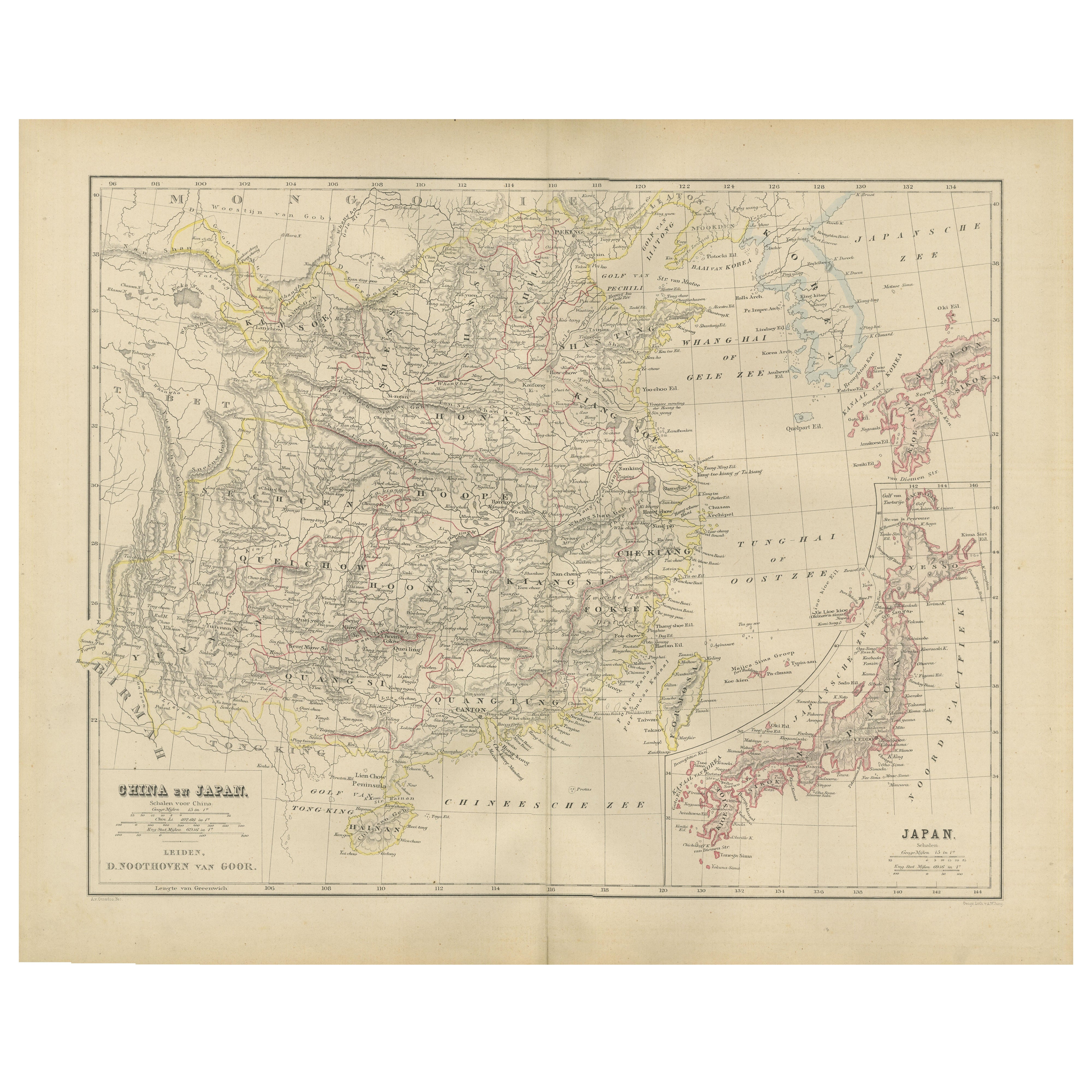
China and Japan Map with Korea – Nieuwe Hand-Atlas, Leiden 1876
Located in Langweer, NL
China and Japan Map with Korea – Nieuwe Hand-Atlas, Leiden 1876
This finely engraved 19th-century map titled “China en Japan” presents East Asia during a pivotal historical moment, ...
Category
Antique 1870s Dutch Maps
Materials
Paper
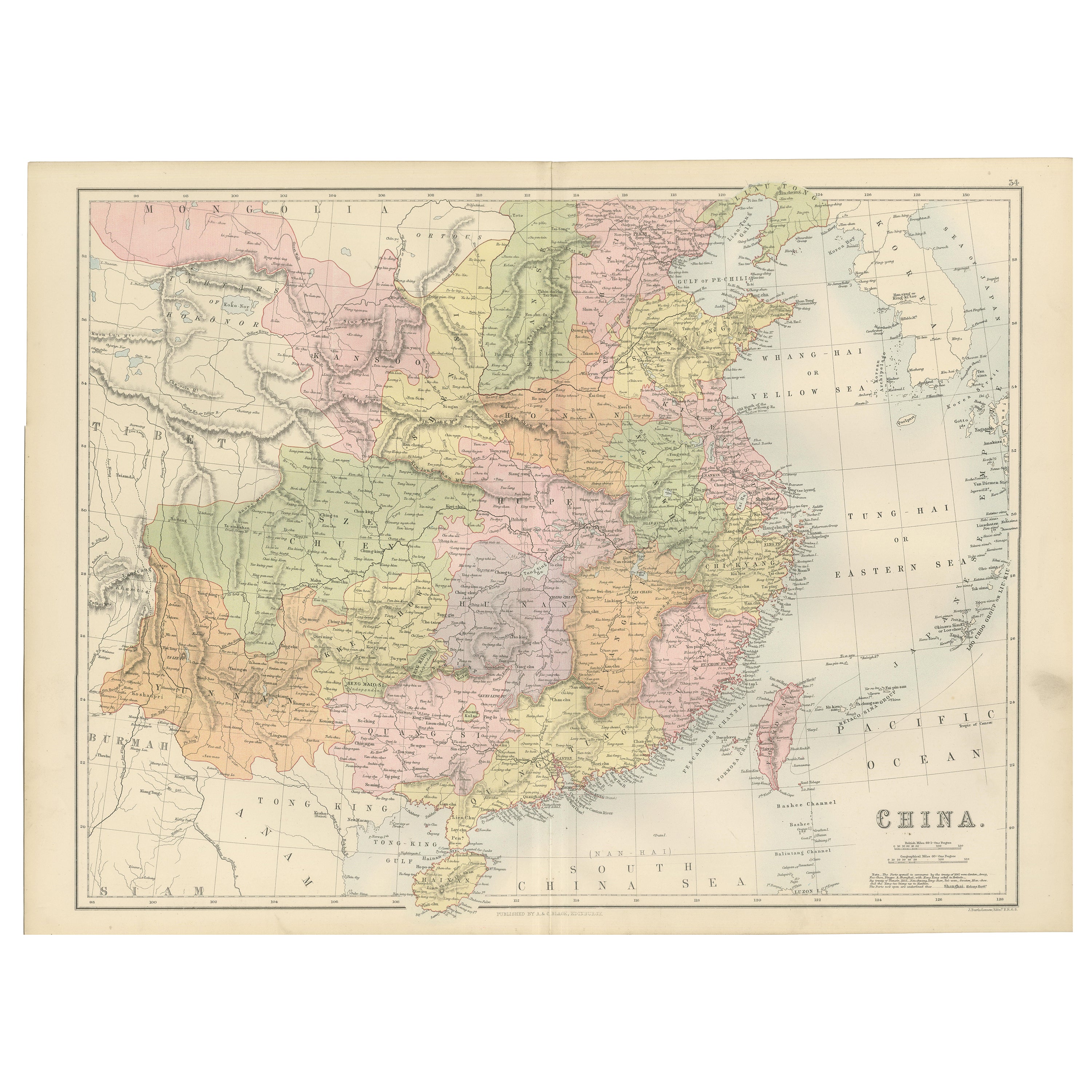
Antique Map of China with Provinces and Treaty Ports – Black’s Atlas, 1884
Located in Langweer, NL
Antique Map of China with Provinces and Treaty Ports – Black’s Atlas, 1884
Description:
This finely engraved and hand-colored map of China was published in the New and Revised Editi...
Category
Antique 1880s Scottish Maps
Materials
Paper
Antique Map of China and Japan by A.K. Johnston, 1865
Located in Langweer, NL
Antique map titled 'China and Japan'. Depicting Eastern China, the Islands of Japan and more. This map originates from the ‘Royal Atlas of Modern Geography’ by Alexander Keith Johnst...
Category
Antique Mid-19th Century Maps
Materials
Paper

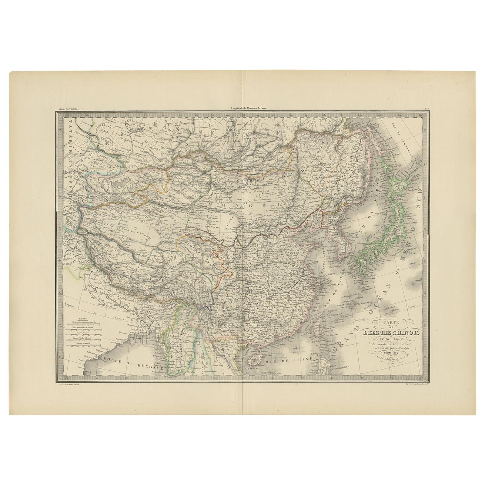
Antique Map of the Chinese Empire and Japan by Lapie, 1842
Located in Langweer, NL
Antique map titled 'Carte de L'Empire Chinois et du Japon'. Map of the Chinese Empire (China) and Japan. This map originates from 'Atlas universel de géographie ancienne et moderne (...
Category
Antique Mid-19th Century Maps
Materials
Paper

You May Also Like
China and Japan, English antique map by Alexander Keith Johnston, 1901
Located in Melbourne, Victoria
'China and Japan', antique lithographic map by Keith Johnston.
Central vertical fold as issued.
495mm by 625mm (sheet)
Alexander Keith Johnston FRS...
Category
Early 20th Century Victorian More Prints
Materials
Lithograph

Original Antique Map of China, Arrowsmith, 1820
Located in St Annes, Lancashire
Great map of China
Drawn under the direction of Arrowsmith
Copper-plate engraving
Published by Longman, Hurst, Rees, Orme and Brown, 1820
Unfr...
Category
Antique 1820s English Maps
Materials
Paper

Large Original Vintage Map of China, circa 1920
Located in St Annes, Lancashire
Great map of China.
Original color. Good condition.
Published by Alexander Gross
Unframed.
Category
Vintage 1920s English Edwardian Maps
Materials
Paper

Large Original Antique Map of Asia by Sidney Hall, 1847
Located in St Annes, Lancashire
Great map of Asia
Drawn and engraved by Sidney Hall
Steel engraving
Original colour outline
Published by A & C Black. 1847
Unframed
Free shipping
Category
Antique 1840s Scottish Maps
Materials
Paper

Super Rare Antique French Map of Chine and the Chinese Empire, 1780
Located in Amsterdam, Noord Holland
Super Rare Antique French Map of Chine and the Chinese Empire, 1780
Very nice map of Asia. 1780 Made by Bonne.
Additional information:
Type: Map
...
Category
Antique 18th Century European Maps
Materials
Paper

$438 Sale Price
49% Off
Antique 1803 Italian Map of Asia Including China Indoneseia India
Located in Amsterdam, Noord Holland
Antique 1803 Italian Map of Asia Including China Indoneseia India
Very nice map of Asia. 1803.
Additional information:
Type: Map
Country of Manufacturing: Europe
Period: 19th centu...
Category
Antique 19th Century European Maps
Materials
Paper

$438 Sale Price
39% Off
More Ways To Browse
Imperial China
Chinese And Japanese Antique Furniture
Japan Antiques Collectables
Commodore Perry
Pair Of Danish Chairs
Veneer Dining Tables
1970 Italian Armchair
Furniture Uk
House Of Denmark Table And Chairs
Louis Marble Top Side Table
Antique Russian Rugs
Baker Furniture By
For Kids
Sterling Silver Flatware Set Service For 12
Tufted Bar
Pair Of French Antique Armchairs
1970s Brass Glass Coffee Table
Antique Column Base