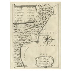
Items Similar to Antique Map of the City of Algiers and Surroundings in Northern Africa, 1773

Want more images or videos?
Request additional images or videos from the seller
1 of 10
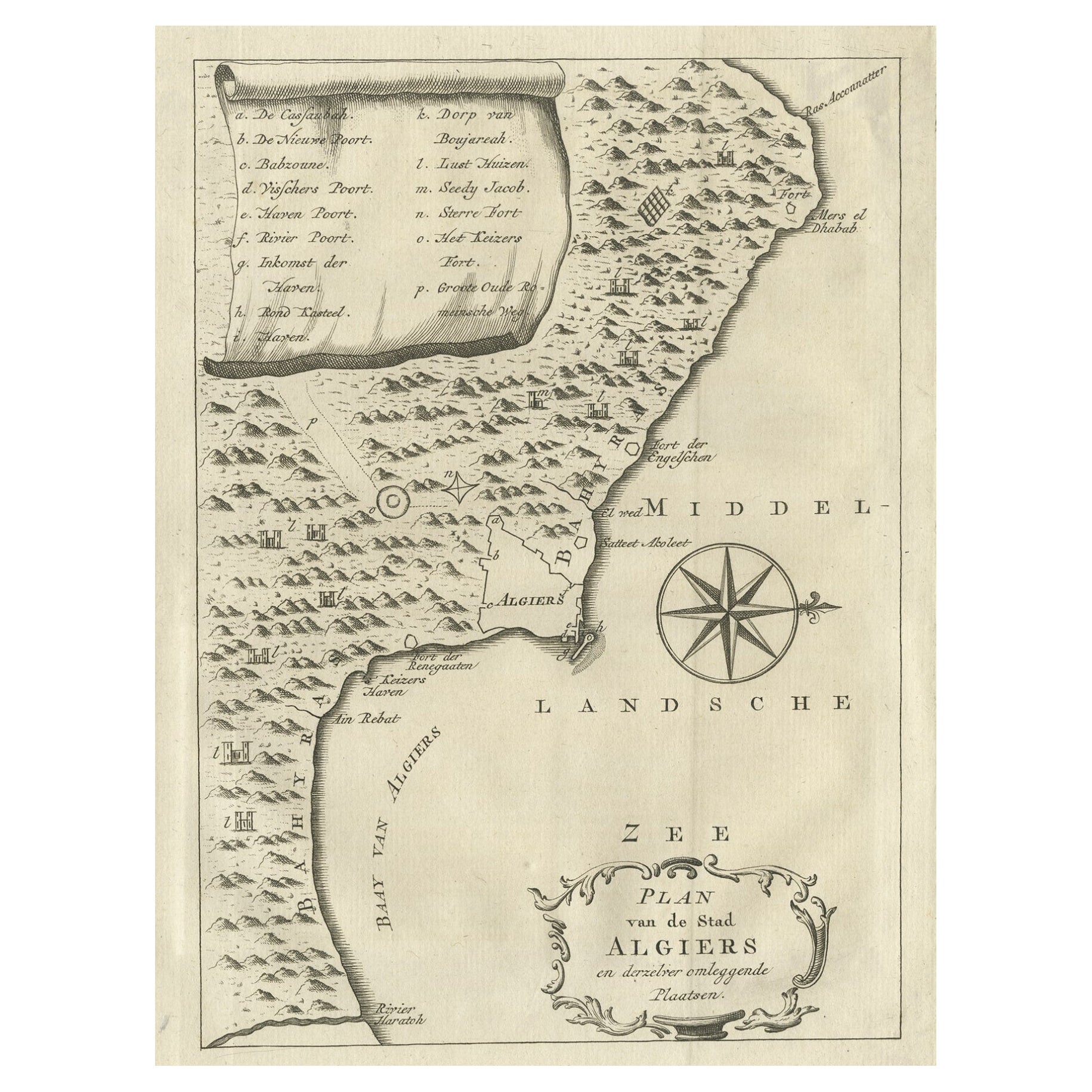
Antique Map of the City of Algiers and Surroundings in Northern Africa, 1773
$213.58
£159.45
€180
CA$296.73
A$319.17
CHF 170.58
MX$3,762.14
NOK 2,150.55
SEK 1,966.01
DKK 1,371.80
About the Item
Antique print titled 'Plan van de Stad Algiers'. Old map of Algiers, also depicting surrounding cities and the Bay of Algiers. Originates from the first Dutch editon of an interesting travel account of Northern Africa titled 'Reizen en Aanmerkingen door en over Barbaryen en het Ooste'.
Algiers (Arabic Berber: Dzayer; French: Alger) is the capital and largest city of Algeria. The city's population in 2011 was estimated to be around 3,500,000. An estimate puts the population of the larger metropolitan city to be around 5,000,000. Algiers is located on the Mediterranean Sea and in the north-central portion of Algeria. Algiers is situated on the west side of a bay of the Mediterranean Sea. The modern part of the city is built on the level ground by the seashore; the old part, the ancient city of the deys, climbs the steep hill behind the modern town and is crowned by the Casbah or citadel, 122 metres (400 ft) above the sea. The casbah and the two quays form a triangle.
Artists and Engravers: Author: T. Shaw. Translated by P. Boddaert and published by J. van Schoonhoven.
Condition: Very good, general age-related toning. Please study image carefully.
Date: 1773
Overall size: 20.5 x 26.5 cm.
Image size: 16 x 22 cm.
We sell original antique maps to collectors, historians, educators and interior decorators all over the world. Our collection includes a wide range of authentic antique maps from the 16th to the 20th centuries. Buying and collecting antique maps is a tradition that goes back hundreds of years. Antique maps have proved a richly rewarding investment over the past decade, thanks to a growing appreciation of their unique historical appeal. Today the decorative qualities of antique maps are widely recognized by interior designers who appreciate their beauty and design flexibility. Depending on the individual map, presentation, and context, a rare or antique map can be modern, traditional, abstract, figurative, serious or whimsical. We offer a wide range of authentic antique maps for any budget.
- Dimensions:Height: 10.44 in (26.5 cm)Width: 8.08 in (20.5 cm)Depth: 0.01 in (0.2 mm)
- Materials and Techniques:
- Period:
- Date of Manufacture:1773
- Condition:Condition: Very good, general age-related toning. Please study image carefully.
- Seller Location:Langweer, NL
- Reference Number:Seller: BG-11797-251stDibs: LU3054325992292
About the Seller
5.0
Recognized Seller
These prestigious sellers are industry leaders and represent the highest echelon for item quality and design.
Platinum Seller
Premium sellers with a 4.7+ rating and 24-hour response times
Established in 2009
1stDibs seller since 2017
2,836 sales on 1stDibs
Typical response time: 1 hour
- ShippingRetrieving quote...Shipping from: Langweer, Netherlands
- Return Policy
More From This Seller
View AllOld Map of Algiers, with Surrounding Cities and the Bay of Algiers, 1773
Located in Langweer, NL
Antique print titled 'Plan van de Stad Algiers'.
Old map of Algiers, also depicting surrounding cities and the Bay of Algiers. Originates from the first Dutch editon of an interest...
Category
Antique 1770s Maps
Materials
Paper
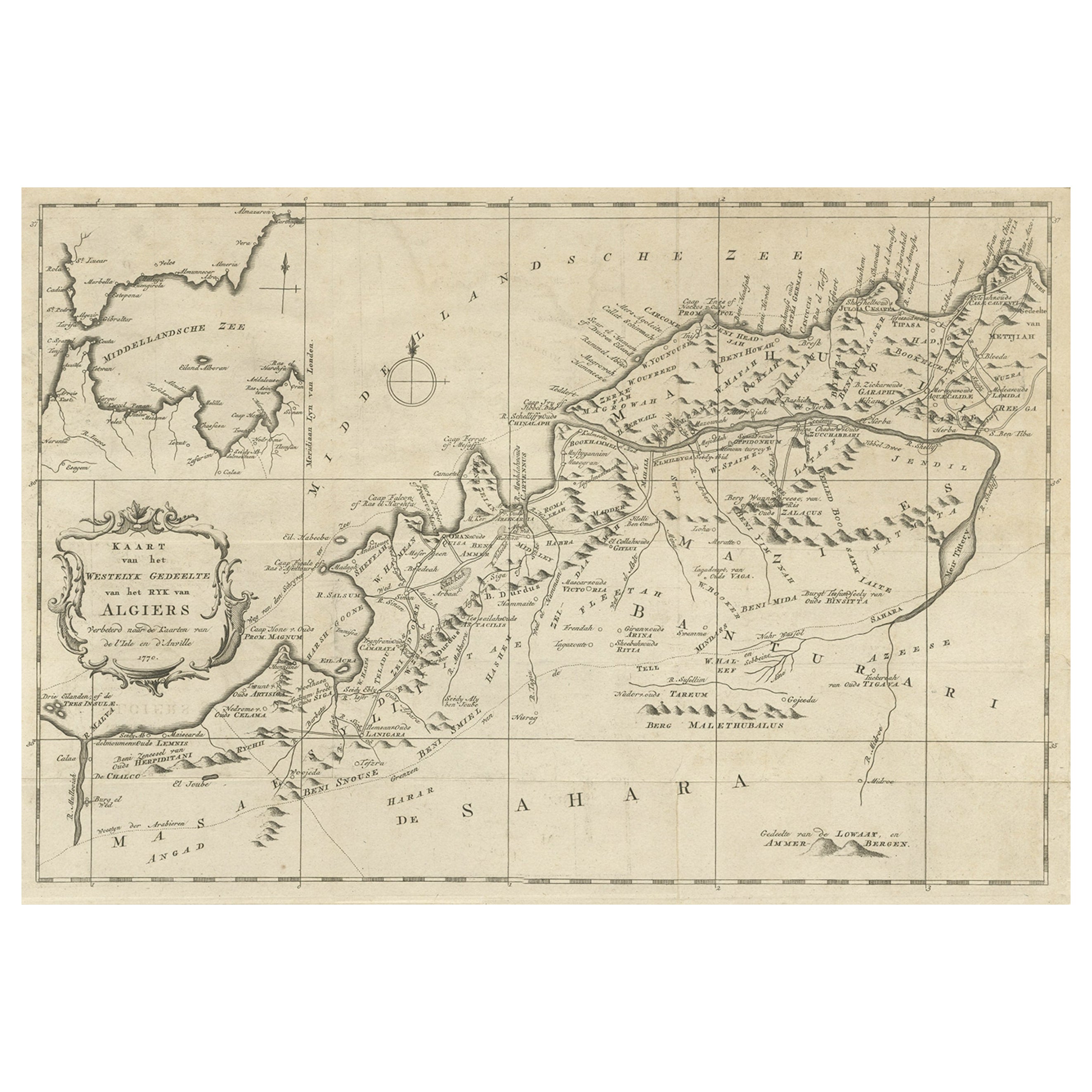
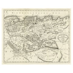
Old Map of the Western Region of the Kingdom of Algiers, Algeria, 1773
Located in Langweer, NL
Antique map titled 'Kaart van het Westelyk Gedeelte van het Ryk van Algiers'.
Old map of the western region of the Kingdom of Algiers, Algeria. Originates from the first Dutch ed...
Category
Antique 1770s Maps
Materials
Paper
$360 Sale Price
20% Off
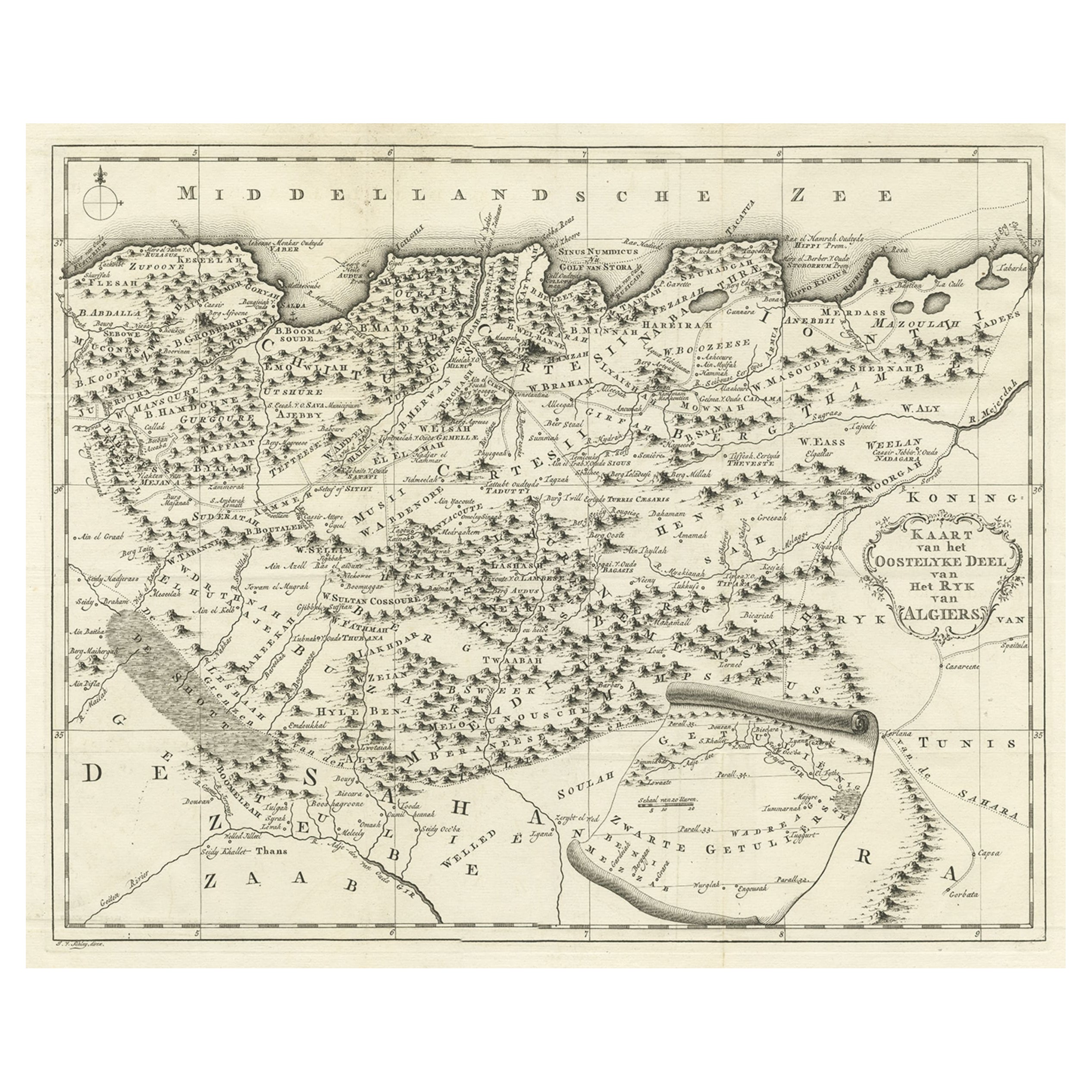
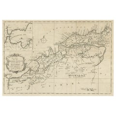
Old Map of the Eastern Region of the Kingdom of Algiers, Algeria, 1773
Located in Langweer, NL
Antique map titled 'Kaart van het Oostelyke Deel van het Ryk van Algiers'.
Old map of the eastern region of the Kingdom of Algiers, Algeria. Originates from the first Dutch edito...
Category
Antique 1770s Maps
Materials
Paper
$436 Sale Price
20% Off
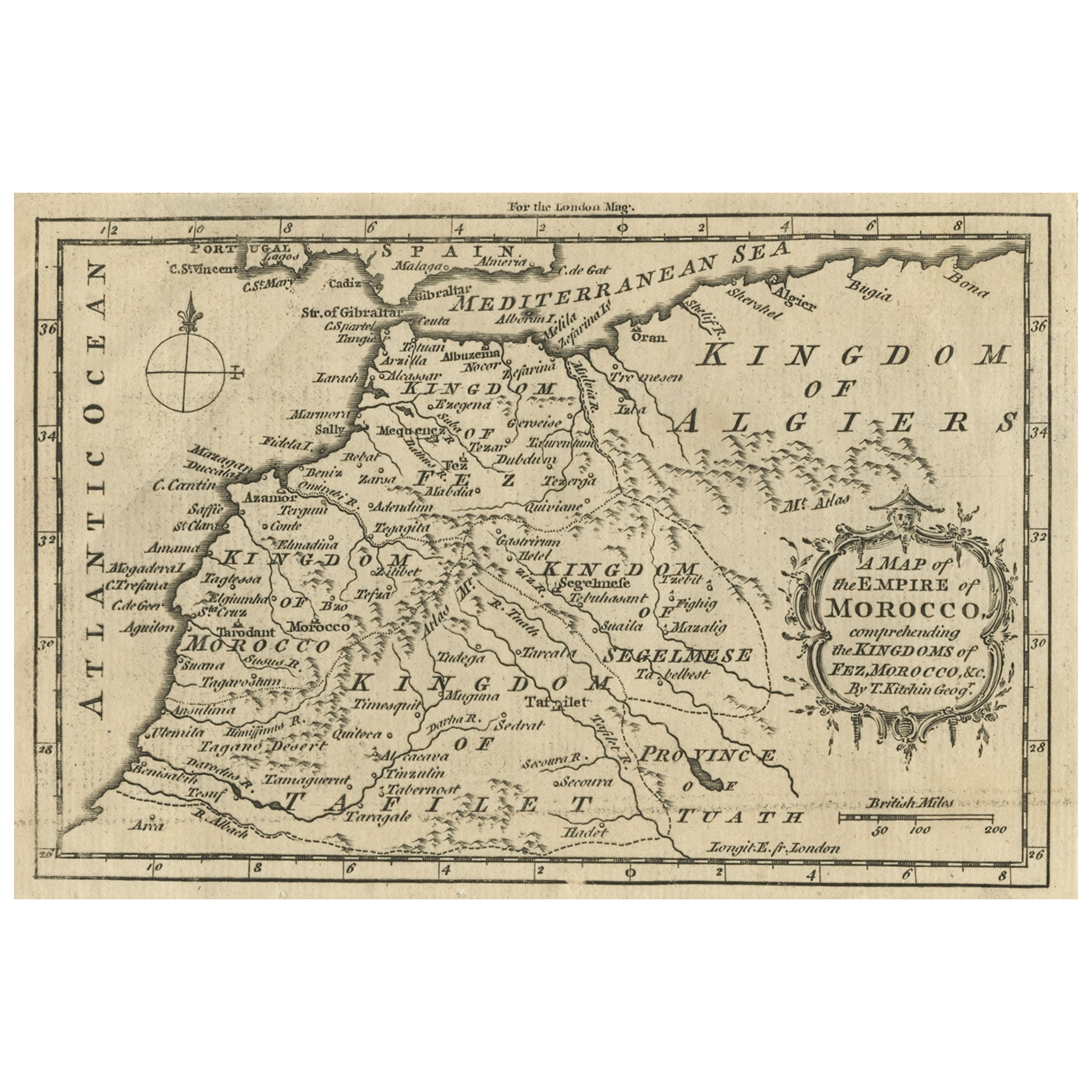
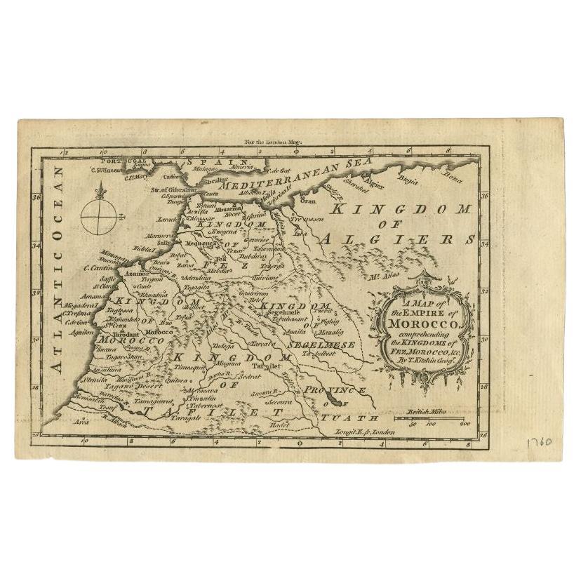
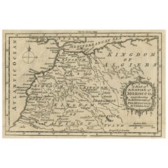
Old Map of the Kingdoms of Fez, Algiers, Segelmese, Tafilet and Morocco, ca.1760
Located in Langweer, NL
Antique map titled 'A Map of the Empire of Morocco Comprehending the Kingdoms of Fez, Morocco'.
Original antique map of the kingdoms of Fez, Algiers, Segelmese, Tafilet and Moroc...
Category
Antique 1760s British Maps
Materials
Paper
Detailed Original Old Map of the Southern Region of the Kingdom of Algiers 1773
Located in Langweer, NL
Antique map titled 'Kaart van het Zuidelyk Gedeelte van het Ryk Algiers'.
Old map of the southern region of the Kingdom of Algiers, Algeria. Originates from the first Dutch edito...
Category
Antique 18th Century Maps
Materials
Paper

Antique Map of the Empire of Morocco by Kitchin, c.1760
By Thomas Kitchin
Located in Langweer, NL
Antique map titled 'A Map of the Empire of Morocco Comprehending the Kingdoms of Fez, Morocco'. Original antique map of the kingdoms of Fez, Algiers, Segelmese, Tafilet and Morocco. ...
Category
Antique 18th Century British Maps
Materials
Paper
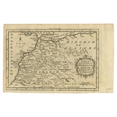
$170 Sale Price
20% Off
You May Also Like
West Coast of Africa, Guinea
Sierra Leone: An 18th Century Map by Bellin
By Jacques-Nicolas Bellin
Located in Alamo, CA
Jacques Bellin's copper-plate map entitled "Partie de la Coste de Guinee Dupuis la Riviere de Sierra Leona Jusquau Cap das Palmas", depicting the coast of Guinea and Sierra Leone in ...
Category
Antique Mid-18th Century French Maps
Materials
Paper

Original Antique Map of Ancient Greece, Achaia, Corinth, 1786
Located in St Annes, Lancashire
Great map of Ancient Greece. Showing the region of Thessaly, including Mount Olympus
Drawn by J.D. Barbie Du Bocage
Copper plate engraving by P.F Tardieu
Original hand color...
Category
Antique 1780s French Other Maps
Materials
Paper

1654 Joan Blaeu Map the Sutherland, Scotland, Entitled "Southerlandia, "Ric0007
Located in Norton, MA
1654 Joan Blaeu map of the
Sutherland, Scotland, entitled
"Southerlandia,"
Hand Colored
Ric0007
Description:
Lovely map centered on Sedan and D...
Category
Antique 17th Century Dutch Maps
Materials
Paper

1627 Hendrik Hondius Map Entitled "Vltoniae Orientalis Pars, " Ric.a009
Located in Norton, MA
1627 Hendrik Hondius map entitled
"Vltoniae orientalis pars,"
Ric.a009
Title:
Vltoniae orientalis : pars
Title (alt.) :
Ultoniae orientalis pars
Creator:
Mercator, Gerh...
Category
Antique 17th Century Dutch Maps
Materials
Paper

Original Antique Map of Ancient Greece- Boeotia, Thebes, 1787
Located in St Annes, Lancashire
Great map of Ancient Greece. Showing the region of Boeotia, including Thebes
Drawn by J.D. Barbie Du Bocage
Copper plate engraving by P.F T...
Category
Antique 1780s French Other Maps
Materials
Paper

Southern Greece: A Large 17th C. Hand-colored Map by Sanson and Jaillot
By Nicolas Sanson
Located in Alamo, CA
This large original hand-colored copperplate engraved map of southern Greece and the Pelopponese Peninsula entitled "La Moree Et Les Isles De Zante, Cefalonie, Ste. Marie, Cerigo & C...
Category
Antique 1690s French Maps
Materials
Paper

More Ways To Browse
Birds Eye View Map
North Africa Map
West Africa Map
Antique Compass Map
Antique Maps California
Biblical Maps
Hungary Map
Maps Of Mediterranean
Treasure Map
Antique Navigational Tools
Mississippi Furniture
Caribbean Antiques
Antique Maps West Indies
Antique Mozambique
Malaysian Antique Furniture
Relief Map
Sur Tout
Antique Civil War Maps