Items Similar to Antique Map of the City of Assen in The Netherlands, 1865


Want more images or videos?
Request additional images or videos from the seller
1 of 7
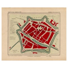
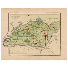
Antique Map of the City of Assen in The Netherlands, 1865
$278.39
$347.9920% Off
£206.30
£257.8820% Off
€232
€29020% Off
CA$380.48
CA$475.6020% Off
A$414.18
A$517.7320% Off
CHF 219.85
CHF 274.8120% Off
MX$4,983.49
MX$6,229.3620% Off
NOK 2,785.77
NOK 3,482.2120% Off
SEK 2,552.55
SEK 3,190.6920% Off
DKK 1,767.21
DKK 2,209.0220% Off
About the Item
Drenthe - Gemeente Assen. (no 2, Stad). These scarse detailed maps of Dutch Towns originate from the 'Gemeente-atlas' of Jacob Kuyper. This atlas of all towns in the Netherlands was published from 1865-1870 and included all towns in the Dutch province of Drenthe. These maps are also known as a Kuyper kaart or Kuyper kaartjes from Drenthe.
Artists and Engravers: Author: Jacob Kuyper: He was one of the most important of the Dutch atlas editors of the second half of the 19th century. He is particularly known for the "Gemeente Atlas", with 1210 plans of all the towns and villages in the Netherlands.
Condition: Fine; occasional foxing as visible on the scans; sheet irregularly cut, not affecting image. Please study image carefully.
Date: 1865
Overall size: 25 x 19.5 cm.
Image size: 19.5 x 16.5 cm.
We sell original antique maps to collectors, historians, educators and interior decorators all over the world. Our collection includes a wide range of authentic antique maps from the 16th to the 20th centuries. Buying and collecting antique maps is a tradition that goes back hundreds of years. Antique maps have proved a richly rewarding investment over the past decade, thanks to a growing appreciation of their unique historical appeal. Today the decorative qualities of antique maps are widely recognized by interior designers who appreciate their beauty and design flexibility. Depending on the individual map, presentation, and context, a rare or antique map can be modern, traditional, abstract, figurative, serious or whimsical. We offer a wide range of authentic antique maps for any budget.
- Dimensions:Height: 7.68 in (19.5 cm)Width: 9.85 in (25 cm)Depth: 0 in (0.01 mm)
- Materials and Techniques:
- Period:
- Date of Manufacture:1865
- Condition:Condition: Fine; occasional foxing as visible on the scans; sheet irregularly cut, not affecting image. Please study image carefully.
- Seller Location:Langweer, NL
- Reference Number:Seller: PCT-158351stDibs: LU3054329643082
About the Seller
5.0
Recognized Seller
These prestigious sellers are industry leaders and represent the highest echelon for item quality and design.
Platinum Seller
Premium sellers with a 4.7+ rating and 24-hour response times
Established in 2009
1stDibs seller since 2017
2,819 sales on 1stDibs
Typical response time: 1 hour
- ShippingRetrieving quote...Shipping from: Langweer, Netherlands
- Return Policy
More From This Seller
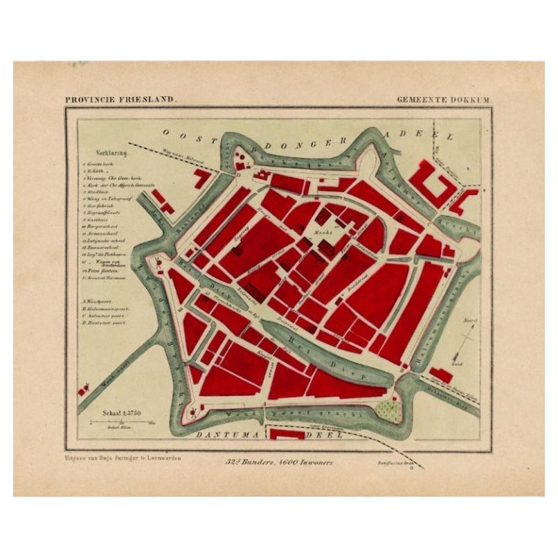
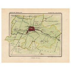
View AllAntique Map of Dokkum a City in the North of Friesland, the Netherlands, 1868
Located in Langweer, NL
Antique map titled 'Provincie Friesland - Gemeente Dokkum'. Map of the township of Dokkum, Friesland. This map originates from 'Gemeente-Atlas van Nederland' by J. Kuyper.
The best-known event in Dokkum's history is the martyrdom of the Anglo-Saxon missionary Saint Boniface (Dutch: Bonifatius) in 754. Oliver of Cologne preached the Fifth Crusade in Dokkum in 1214 and Dokkum sent a contingent; the crescent in the coat of arms of Dokkum refers to this event. Dokkum acquired city rights in 1298. In 1572 Dokkum was sacked by the Spaniards after it had joined the Dutch Revolt...
Category
Antique 19th Century Maps
Materials
Paper
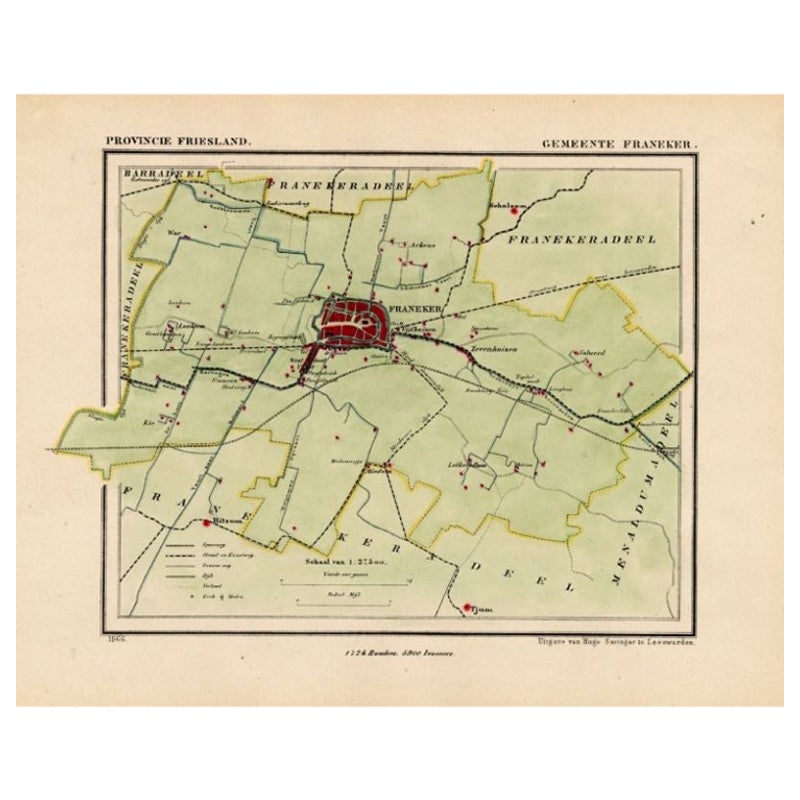
Antique Map of the Township of Franeker in Friesland, the Netherlands, 1865
Located in Langweer, NL
Friesland: Gemeente Franeker. These scarse detailed maps of Dutch Towns originate from the 'Gemeente-atlas' of Jacob Kuyper. This atlas of all towns in the Netherlands was published ...
Category
Antique 19th Century Maps
Materials
Paper
$211 Sale Price
20% Off
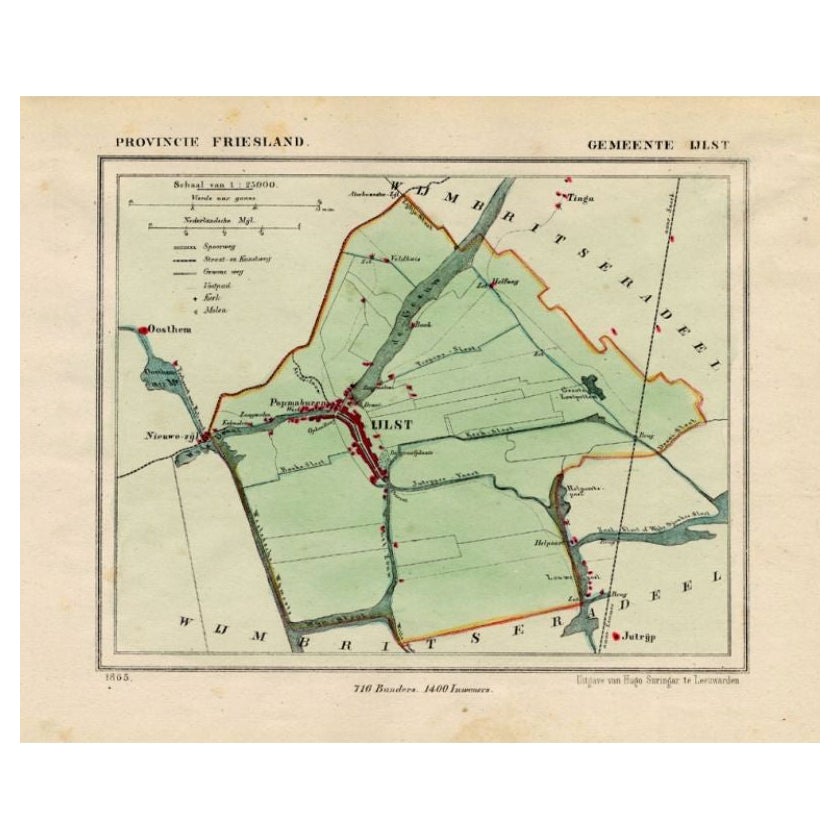
Antique Map of Ijlst , Friesland in the Netherlands, 1865
Located in Langweer, NL
Friesland: Gemeente IjJlst. These scarse detailed maps of Dutch Towns originate from the 'Gemeente-atlas' of Jacob Kuyper. This atlas of all towns in the Netherlands was published fr...
Category
Antique 19th Century Maps
Materials
Paper
$182 Sale Price
20% Off
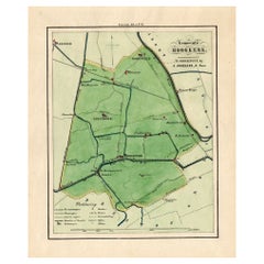
Antique Map of the Township of Hoogkerk in Groningen, The Netherlands, 1862
Located in Langweer, NL
Groningen: Gemeente Dorkwerd-Hoogkerk-Leegkerk-Vinkhuizen. These scarse detailed maps of Dutch Towns originate from the 'Gemeente atlas van de Provincie Groningen in 62 kaarten.' by ...
Category
Antique 19th Century Maps
Materials
Paper
$172 Sale Price
20% Off
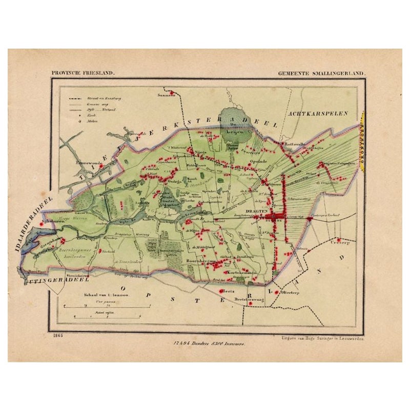
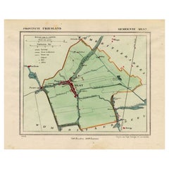
Antique Map of Smallingerland by Kuyper, 1868
Located in Langweer, NL
Antique map titled 'Provincie Friesland - Gemeente Smallingerland'. Map of the township of Smallingerland including Drachten, Opeinde and many other villages. This map originates fro...
Category
Antique 19th Century Maps
Materials
Paper
$127 Sale Price
20% Off
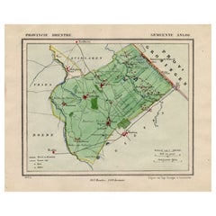
Antique Map of the Township of Anloo in the Netherlands, 1865
Located in Langweer, NL
Drenthe - Gemeente Anloo, Eext, Gasteren, Annen, Schipborg. These scarse detailed maps of Dutch Towns originate from the 'Gemeente-atlas' of Jacob Kuyper. This atlas of all towns in ...
Category
Antique 19th Century Maps
Materials
Paper
$134 Sale Price
20% Off
You May Also Like
Original Antique Map or City Plan of Amsterdam, Netherlands. Circa 1835
Located in St Annes, Lancashire
Nice map of Amsterdam
Drawn and engraved by J.Dower
Published by Orr & Smith. C.1835
Unframed.
Free shipping
Category
Antique 1830s English Maps
Materials
Paper

Original Antique English County Map, Huntingdonshire, J
C Walker, 1851
Located in St Annes, Lancashire
Great map of Huntingdonshire
Original colour
By J & C Walker
Published by Longman, Rees, Orme, Brown & Co. 1851
Unframed.
Category
Antique 1850s English Other Maps
Materials
Paper

Original Antique English County Map, Cambridgeshire, J
C Walker, 1851
Located in St Annes, Lancashire
Great map of Cambridgeshire
Original colour
By J & C Walker
Published by Longman, Rees, Orme, Brown & Co. 1851
Unframed.
Category
Antique 1850s English Other Maps
Materials
Paper

Original Antique Map or City Plan of Rome, Italy. Circa 1835
Located in St Annes, Lancashire
Nice map of Rome
Drawn and engraved by J.Dower
Published by Orr & Smith. C.1835
Unframed.
Free shipping
Category
Antique 1830s English Maps
Materials
Paper

Original Antique English County Map, Buckinghamshire, J
C Walker, 1851
Located in St Annes, Lancashire
Great map of Buckinghamshire
Original colour
By J & C Walker
Published by Longman, Rees, Orme, Brown & Co. 1851
Unframed.
Category
Antique 1850s English Other Maps
Materials
Paper

Original Antique English County Map, Derbyshire, J
C Walker, 1851
Located in St Annes, Lancashire
Great map of Derbyshire
Original colour
By J & C Walker
Published by Longman, Rees, Orme, Brown & Co. 1851
Unframed.
Category
Antique 1850s English Other Maps
Materials
Paper

More Ways To Browse
Napoleon Map
Rand Mcnally Vintage Maps
Tunisia Antique Map
Used Office Furniture Rhode Island
Antique Chesapeake Bay Map
Antique Copper Australia
Antique Furniture Pondicherry
Antique Map Of Cornwall
Antique Maps Dublin
Antique Maps Of Malta
Antique Saudi Arabia
Armenia Map
Cambodia Antique Map
Coronelli Globe
Denoyer Geppert Anatomy
E Fletcher
Framed Africa Maps
Gabon Antique Map