Items Similar to Antique Map of the County of Burgundy by Johann Baptist Homann circa 1710


Want more images or videos?
Request additional images or videos from the seller
1 of 7
Antique Map of the County of Burgundy by Johann Baptist Homann circa 1710
$526.56
£394.19
€440
CA$724.88
A$792.44
CHF 419.24
MX$9,482.79
NOK 5,334.16
SEK 4,882.89
DKK 3,352.26
About the Item
Antique Map of the County of Burgundy by Johann Baptist Homann circa 1710 Hand-Colored
This finely detailed antique map titled Comitatus Burgundia depicts the historic region of the County of Burgundy, also known as Franche-Comté, in eastern France. Created by the prominent German cartographer Johann Baptist Homann in the early 18th century, this copper-engraved map presents an intricate representation of the area, including its cities, rivers, mountains, and road networks. The original hand-coloring highlights the territorial divisions, distinguishing the major administrative regions within Franche-Comté.
The elaborate title cartouche in the lower right corner features allegorical figures, a seated noblewoman, military iconography, and a reference to the Holy Roman Empire, reflecting the political significance of the region at the time. The map also shows parts of the surrounding regions, including Switzerland, the Duchy of Burgundy, and Lorraine. The inclusion of Lake Geneva and the Jura Mountains adds to the geographical depth of the depiction. Homann’s work was widely regarded for its precision and artistic quality, making this map an important historical artifact for collectors and scholars interested in early French and European cartography.
Condition summary
This antique map is in fair to good condition with well-preserved original hand coloring that enhances the territorial distinctions. The paper has developed a natural patina, consistent with its age, and shows light age toning, particularly along the margins. Minor foxing and small stains are present, but they do not interfere with the detailed engraving. The edges show slight wear, including some creasing and small tears, typical of maps from this period. The central fold is visible, as expected from an atlas map, but remains intact with no major separations. The engraved details and inscriptions remain sharp and legible, preserving the historical and artistic value of the piece.
Framing tips
To ensure the proper preservation and presentation of this antique map, it is recommended to use archival materials. UV-protective glass or acrylic will safeguard the hand coloring from fading over time. Acid-free matting in neutral or antique tones will help highlight the fine details and provide protection against environmental damage. A classic wooden frame with a dark-stained or gilded finish will complement the historical character of the map. Museum-grade mounting techniques should be employed to prevent any adhesive damage, ensuring the longevity of this valuable historical document. This map serves as an excellent decorative and scholarly addition to any collection, offering insight into the political and geographical landscape of early 18th-century Burgundy.
- Dimensions:Height: 24.02 in (61 cm)Width: 20.48 in (52 cm)Depth: 0.01 in (0.2 mm)
- Materials and Techniques:Paper,Engraved
- Period:1720-1729
- Date of Manufacture:circa 1720
- Condition:Repaired: some support along the edge with tape. The condition reflects its age, with gentle toning, slight foxing, mild edge wear and wrinkles. Tape support in the top border. Details remain legible, and the coloring and engraving are still clear.
- Seller Location:Langweer, NL
- Reference Number:Seller: BG-13659-21stDibs: LU3054343856712
About the Seller
5.0
Recognized Seller
These prestigious sellers are industry leaders and represent the highest echelon for item quality and design.
Platinum Seller
Premium sellers with a 4.7+ rating and 24-hour response times
Established in 2009
1stDibs seller since 2017
2,792 sales on 1stDibs
Typical response time: <1 hour
- ShippingRetrieving quote...Shipping from: Langweer, Netherlands
- Return Policy
More From This Seller
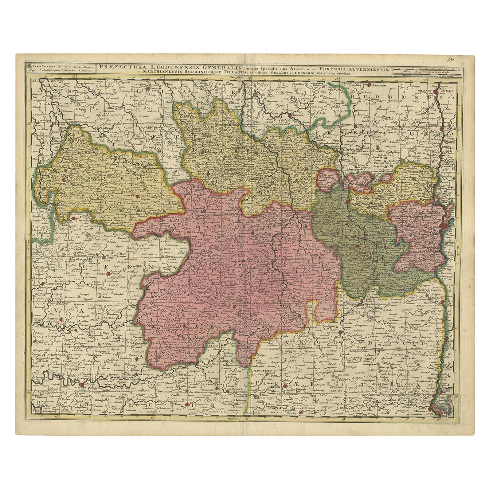
View AllAntique Map of the Auvergne-Rhône-Alpes region of France by Valk, circa 1730
Located in Langweer, NL
Antique map titled 'Praefectura Lugdunensis Generalis'. Detailed map of the Auvergne-Rhône-Alpes region in the southeast of France. To the east the Rhône from Chalon-sur-Saône, Mâcon...
Category
Antique Mid-18th Century Maps
Materials
Paper
Antique Map of the Lorraine
North-East France
by J. B. Homann, circa 1720
Located in Langweer, NL
Antique map of Lorraine in north-east France by J. B. Homann. Covering the area around Metz, Nancy and Sarrebruck with Luxembourg in the North and Mulhouse in Southeast. With a decor...
Category
Antique Early 18th Century Maps
Materials
Paper

Antique Map of the Limoges Region in France, c.1690
Located in Langweer, NL
Antique map titled 'Le Diocèse de Limoges'. Large map of the Limoges region, France.
The map is dedicated to the bishop of Limoges, Antoine de Charpin.
Artists and Engravers:...
Category
Antique 17th Century Maps
Materials
Paper

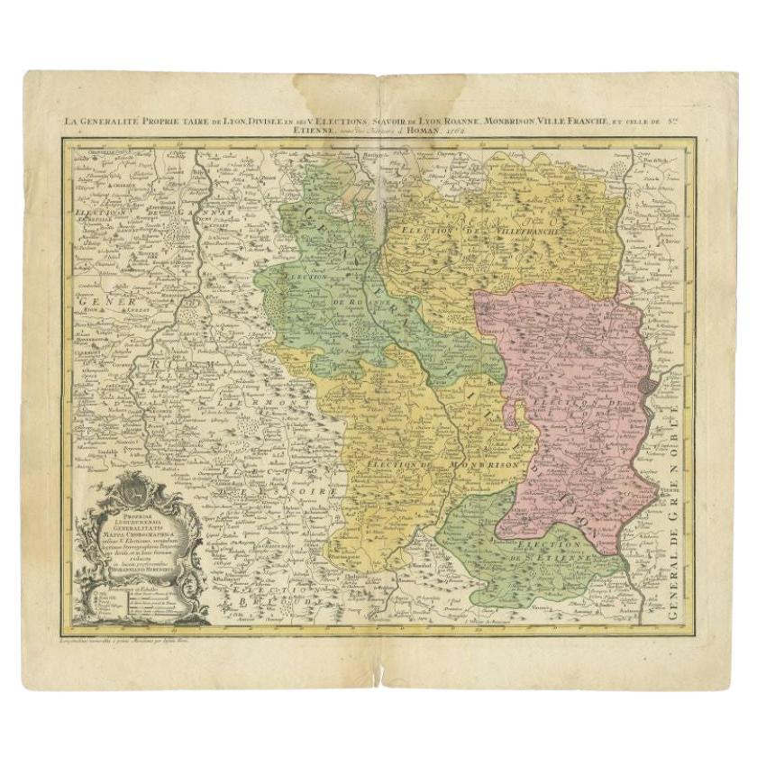
Antique Map of the Beaujolais Region by Homann Heirs, 1762
Located in Langweer, NL
Antique map titled 'La Generalite Proprie Taire De Lyon (..) - Propriae Lugudunensis Generalitatis (..)'. Detailed regional map of the Beaujolais region including the cities of Lyon,...
Category
Antique 18th Century Maps
Materials
Paper
Antique Map of the Alsace Region of France by Schenk
circa 1700
Located in Langweer, NL
Antique map titled 'Superioris atque Inferioris Alsatiae'. Beautiful map of the Alsace region, from Basel in the south to Philipsburg in the north, centered on Strassburg. Published ...
Category
Antique Early 18th Century Maps
Materials
Paper

Antique Map of the Namur Region
France
by F. de Wit, circa 1680
Located in Langweer, NL
Antique map titled 'Comitatus Namurci Tabula in Lucem Edita'. Large map of the Namur region, France. Published by F. de Wit, circa 1680.
Category
Antique Late 17th Century Maps
Materials
Paper

$550 Sale Price
20% Off
You May Also Like
1771 Bonne Map of Poitou, Touraine and Anjou, France, Ric.a015
Located in Norton, MA
1771 Bonne Map of Poitou,
Touraine and Anjou, France
Ric.a015
1771 Bonne map of Potiou, Touraine and Anjou entitled "Carte des Gouvernements D'Anjou et du Saumurois, de la Touraine, du Poitou,du Pays d'aunis, Saintonge?Angoumois,"
Carte des gouvernements d'Anjou et du Saumurois, de la Touraine, du Poitou, du Pays d'Aunis, Saintonge-Angoumois. Projettee et assujettie au ciel par M. Bonne, Hyd. du Roi. A Paris, Chez Lattre, rue St. Jacques a la Ville de Bord(ea)ux. Avec priv. du Roi. 1771. Arrivet inv. & sculp., Atlas moderne ou collection de cartes sur toutes...
Category
Antique 17th Century Unknown Maps
Materials
Paper

1640 Joan Bleau Map Entitled"Diocecese de rheims et le pais de rethel, " Eic.a011
Located in Norton, MA
1640 Joan Bleau map entitled
"Diocecese de rheims et le pais de rethel,"
Ric.a011
OAN BLAEU
Diocecese de Rheims, et le pais de Rethel.
Handcolored engraving, c.1640.
...
Category
Antique 17th Century Dutch Maps
Materials
Paper

Hand Colored 18th Century Homann Map of Austria Including Vienna
the Danube
By Johann Baptist Homann
Located in Alamo, CA
"Archiducatus Austriae inferioris" is a hand colored map of Austria created by Johann Baptist Homann (1663-1724) and published in Nuremberg, Germany in 1728 shortly after his death. ...
Category
Early 18th Century Old Masters Landscape Prints
Materials
Engraving

1752 Vaugoundy Map of Flanders : Belgium, France, and the Netherlands, Ric.a002
Located in Norton, MA
Large Vaugoundy Map of Flanders:
Belgium, France, and the Netherlands
Colored -1752
Ric.a002
Description: This is a 1752 Didier Robert de Vaugondy map of Flanders. The map de...
Category
Antique 17th Century Unknown Maps
Materials
Paper

1625 Mercator Map of the Provenience of Quercy, "Quercy Cadvrcivm Ric.0013
Located in Norton, MA
1625 Mercator map of the provenience of Quercy, entitled
"Quercy Cadvrcivm,"
Ric.0013
" Authentic" - Map of the provenience of Quercy Cadvrcivm
D...
Category
Antique 17th Century French Maps
Materials
Paper

1656 Jansson Map Metz Region of France Entitled "Territorium Metense" Ric0014
Located in Norton, MA
1656 Jansson map Metz Region of France entitled "Territorium Metense."
Ric0014
" Authentic" - Map of the historical region surrounding Metz, in Lorraine, France.
Oriented with ...
Category
Antique 17th Century Dutch Maps
Materials
Paper

More Ways To Browse
Sterling Silver Flatware Service For 12
Antique Dining Tables With Leaves
Decorative Wall Panels
Frank Lloyd Wright For Cassina
Natural Curved
Spanish Wool Rug
Leather Pouf And Ottomans
Low Side Tables
Set Of Four Italian Dining Chairs
Silk Runner Carpet
18th Century Blue And White Porcelain
3x5 Rugs
Italian Lacquer Dining Room Sets
Round Brass Table
Round Table Base
Antique Imari Porcelain
Belgian Antiques
Cream Soup