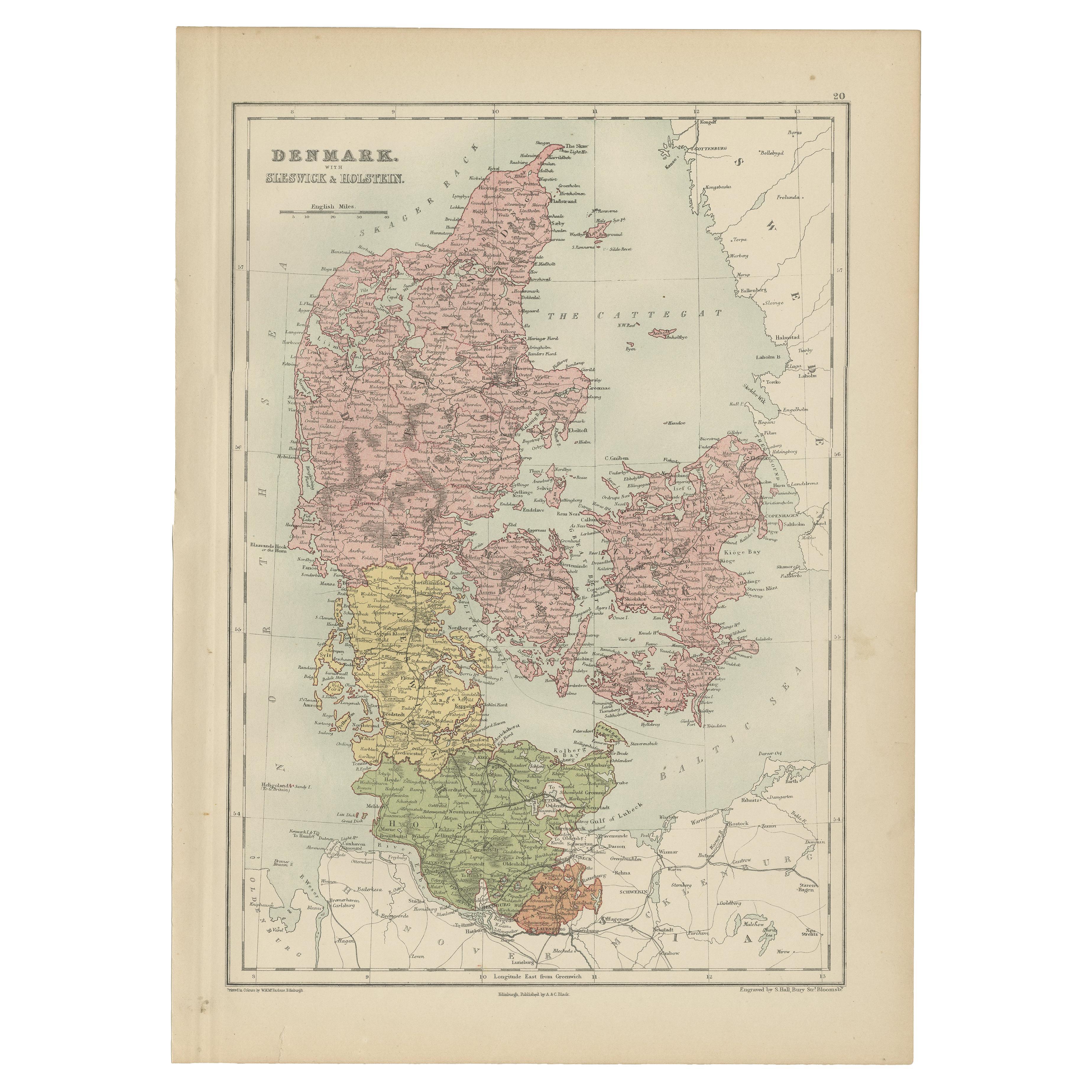
Items Similar to Antique Map of Denmark 1858 – Includes Iceland
Copenhagen Plan
Video Loading
Want more images or videos?
Request additional images or videos from the seller
1 of 11
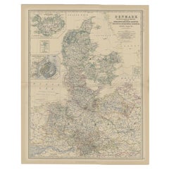
Antique Map of Denmark 1858 – Includes Iceland
Copenhagen Plan
$408.31
£302.41
€340
CA$558.54
A$607.86
CHF 322.23
MX$7,313.07
NOK 4,086.89
SEK 3,739.22
DKK 2,590.86
About the Item
Antique Map of Denmark 1858 – Includes Iceland
Copenhagen Plan
This finely detailed antique map of Denmark was published in 1858 by Justus Perthes in Gotha, as part of the renowned Stieler's Hand-Atlas. Designed and engraved by Friedrich von Stülpnagel, it offers an exceptionally precise cartographic representation of the Kingdom of Denmark in the mid-19th century, with political subdivisions clearly demarcated in original outline color.
The map covers all of Jutland (Jylland), Zealand (Sjælland), Funen (Fyn), and the many surrounding islands, as well as the southern portions of what is today Sweden and northern Germany. It also includes three inset maps that greatly enhance its historical value:
– Iceland (Island): Shown in the upper-left, labeled in German with mountain ranges and key settlements
– The Faroe Islands (Fär-Öer): In the lower-left, a compact but legible depiction
– Hamburg and Environs: A city plan showing key roads and waterways
– Copenhagen (Kopenhagen): Detailed inset map in the upper right corner, showcasing the fortifications, harbors, and important buildings of the Danish capital in the mid-19th century
Place names are rendered in German and reflect contemporary political boundaries of the Danish monarchy, which at the time still retained significant influence over Schleswig and Holstein. Railways, canals, rivers, mountains, and administrative boundaries are all meticulously engraved and labeled.
Von Stülpnagel was a respected cartographer known for his clarity and geographic precision, and his work on the Stieler Atlas remains a standard in 19th-century German cartographic excellence. The typography and engraving quality in this map are exceptionally crisp, and the hand-applied coloring adds a decorative quality to the piece.
Ideal for collectors of Scandinavian history, antique maps of Europe, or anyone interested in the political geography of Denmark prior to the major shifts of the late 19th century.
Condition report:
Good condition. Light overall age toning to paper; faint foxing in margins. Original centerfold as issued. Narrow margin along the left edge, not affecting printed area. Plate imprint visible. Colors remain fresh.
Framing tips:
A dark wood or ebonized frame with a cream or pale beige mat will enhance the historical quality of this map. For a Scandinavian minimalist look, consider a light oak frame with an off-white mat.
Technique: Engraving with original hand coloring
Maker: F. von Stülpnagel, Gotha, Justus Perthes, 1858
- Dimensions:Height: 14.77 in (37.5 cm)Width: 17.88 in (45.4 cm)Depth: 0.01 in (0.2 mm)
- Materials and Techniques:Paper,Engraved
- Place of Origin:
- Period:
- Date of Manufacture:1858
- Condition:Good condition. Light overall age toning to paper; faint foxing in margins. Original centerfold as issued. Narrow margin along the left edge, not affecting printed area. Plate imprint visible. Colors remain fresh.
- Seller Location:Langweer, NL
- Reference Number:Seller: BG-05552-231stDibs: LU3054346100422
About the Seller
5.0
Recognized Seller
These prestigious sellers are industry leaders and represent the highest echelon for item quality and design.
Platinum Seller
Premium sellers with a 4.7+ rating and 24-hour response times
Established in 2009
1stDibs seller since 2017
2,813 sales on 1stDibs
Typical response time: 1 hour
- ShippingRetrieving quote...Shipping from: Langweer, Netherlands
- Return Policy
More From This Seller
View AllAntique Map of Denmark with An Inset of Iceland, 1852
Located in Langweer, NL
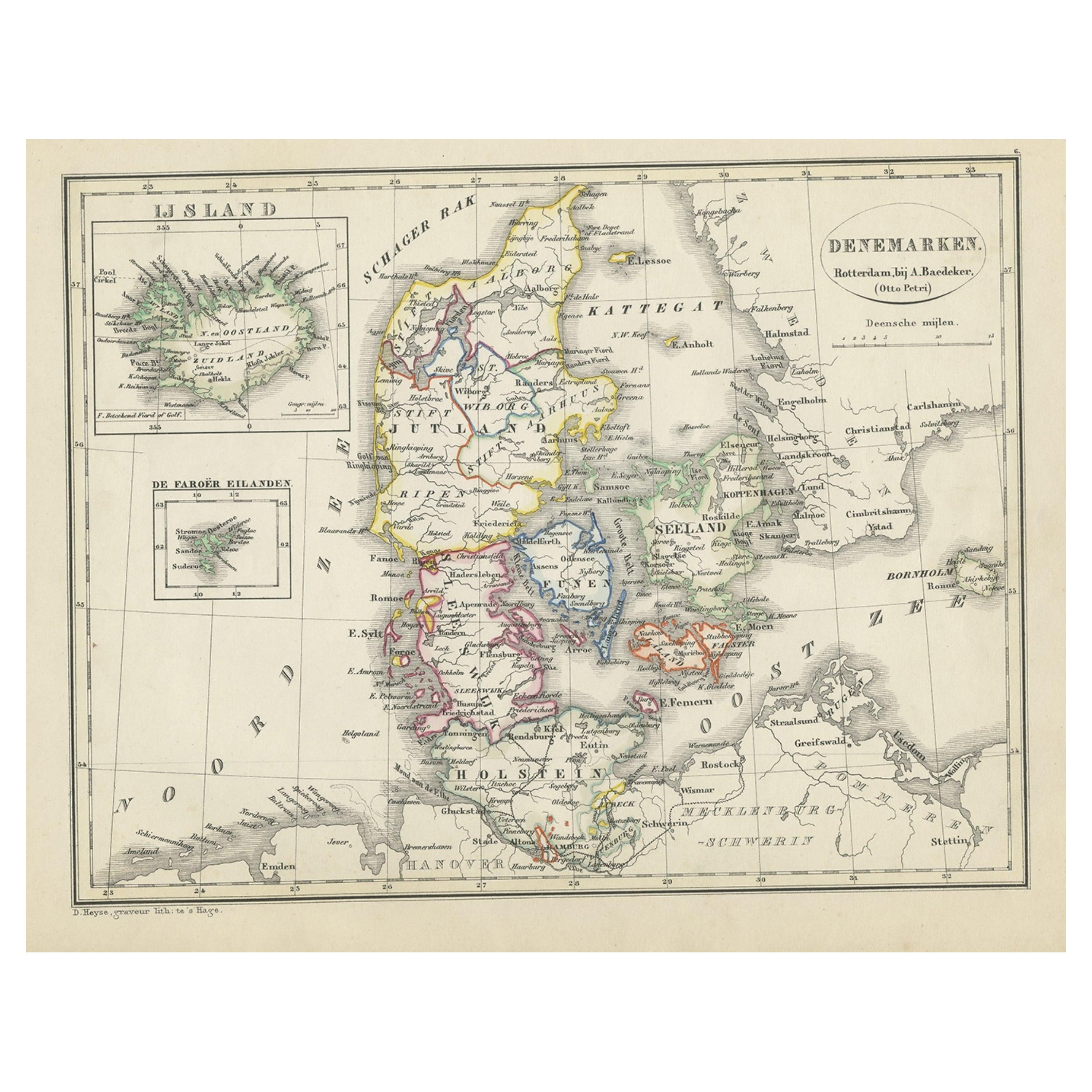
Antique map titled 'Denemarken'. Map of Denmark, with a small inset map of Iceland. This map originates from 'School-Atlas van alle deelen der Aarde' by Otto Petri...
Category
Antique 19th Century Maps
Materials
Paper
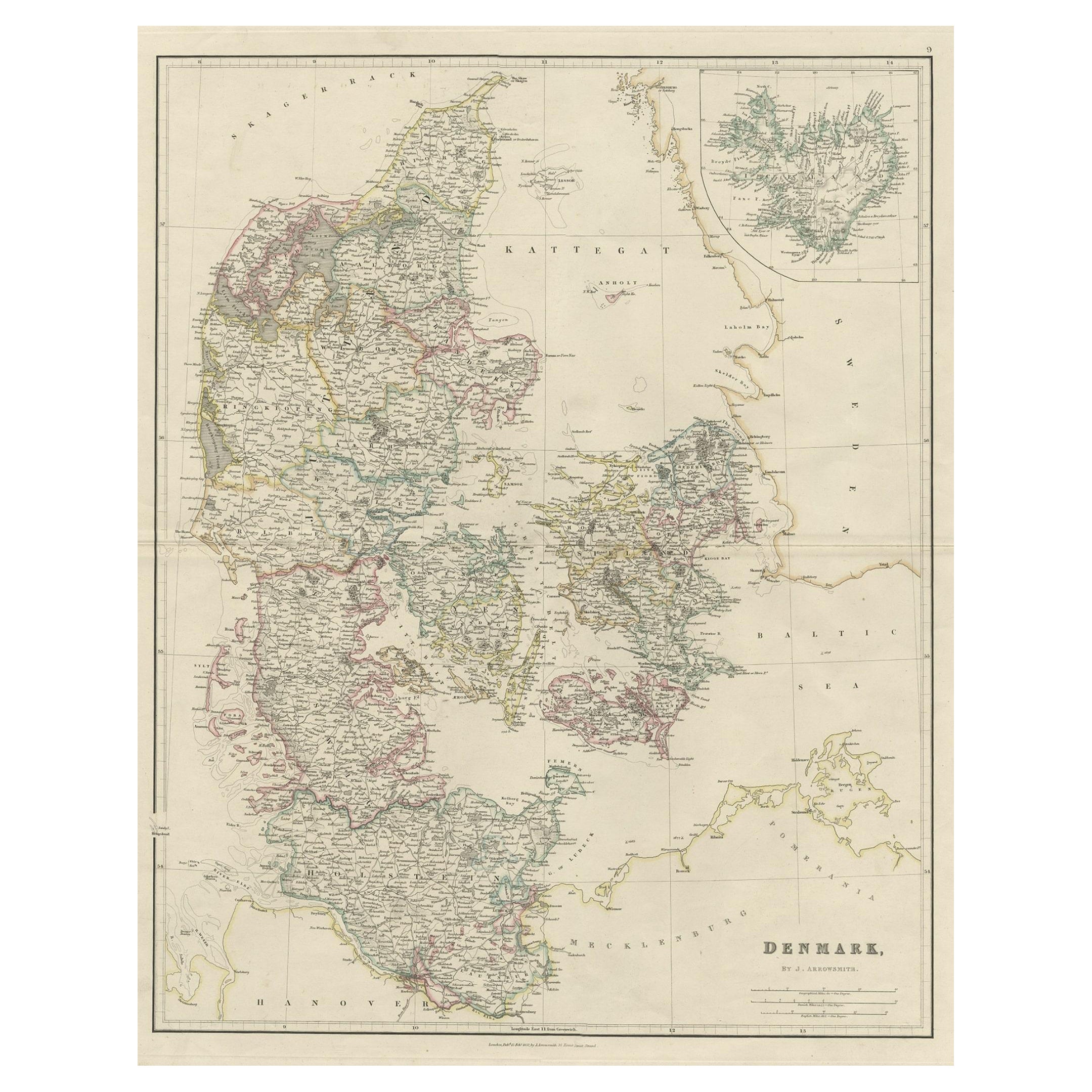
Antique Map of Denmark with an Inset Map of Iceland, 1832
Located in Langweer, NL
Antique map titled 'Denmark'. Large map of Denmark with an inset map of Iceland.
Artists and Engravers: Published by J. Arrowsmith in London, 1832.
Condition: Good, general age...
Category
Antique 19th Century Maps
Materials
Paper

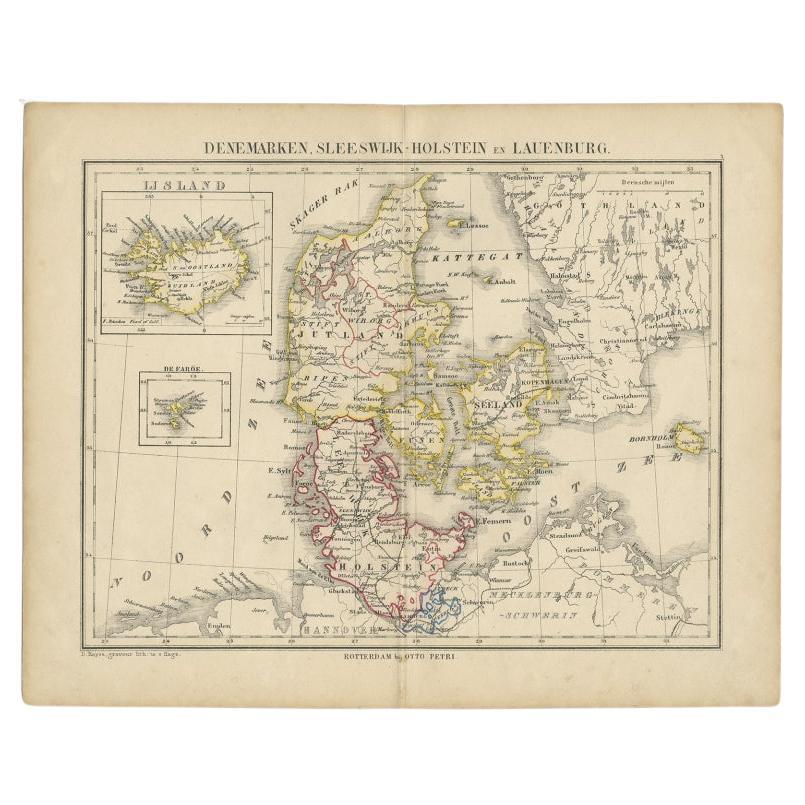
Antique Map of Denmark with Insets of Iceland and the Faroe Islands, c.1873
Located in Langweer, NL
Antique map titled 'Denemarken, Sleeswijk-Holstein en Lauenburg'. Old map depicting Denmark, with inset maps of Iceland and the Faroe Islands. This map originates from 'School-Atlas ...
Category
Antique 19th Century Maps
Materials
Paper
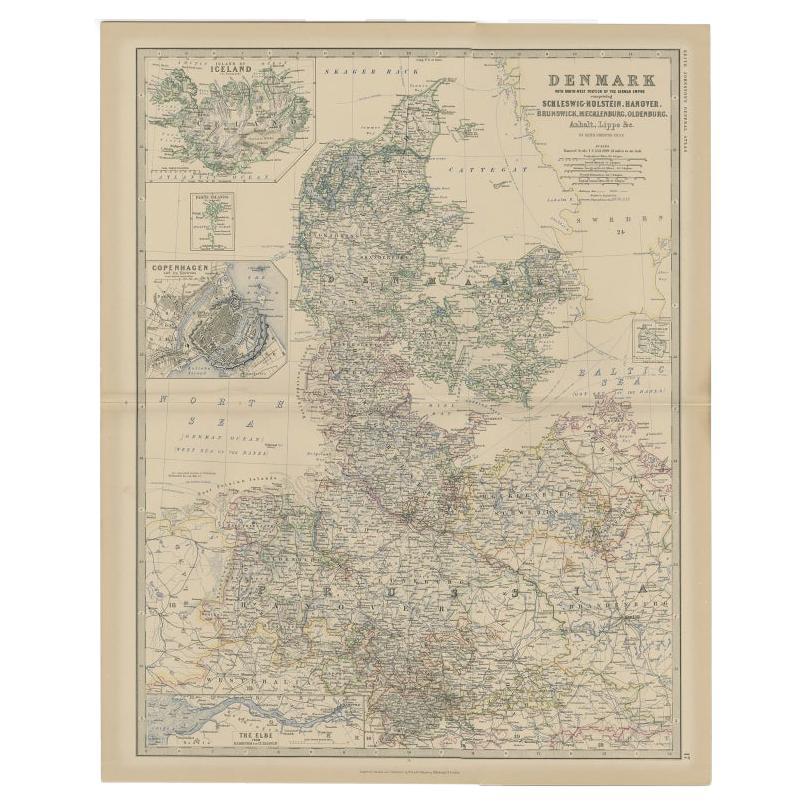
Denmark
German Empire – Antique Map by A.K. Johnston, 1882 Atlas Edition
Located in Langweer, NL
Denmark & German Empire – Antique Map by A.K. Johnston, 1882 Atlas Edition
This detailed antique map titled Denmark with North-West portion of the German Empire comprising Schleswig...
Category
Antique 19th Century English Maps
Materials
Paper
$230 Sale Price
20% Off
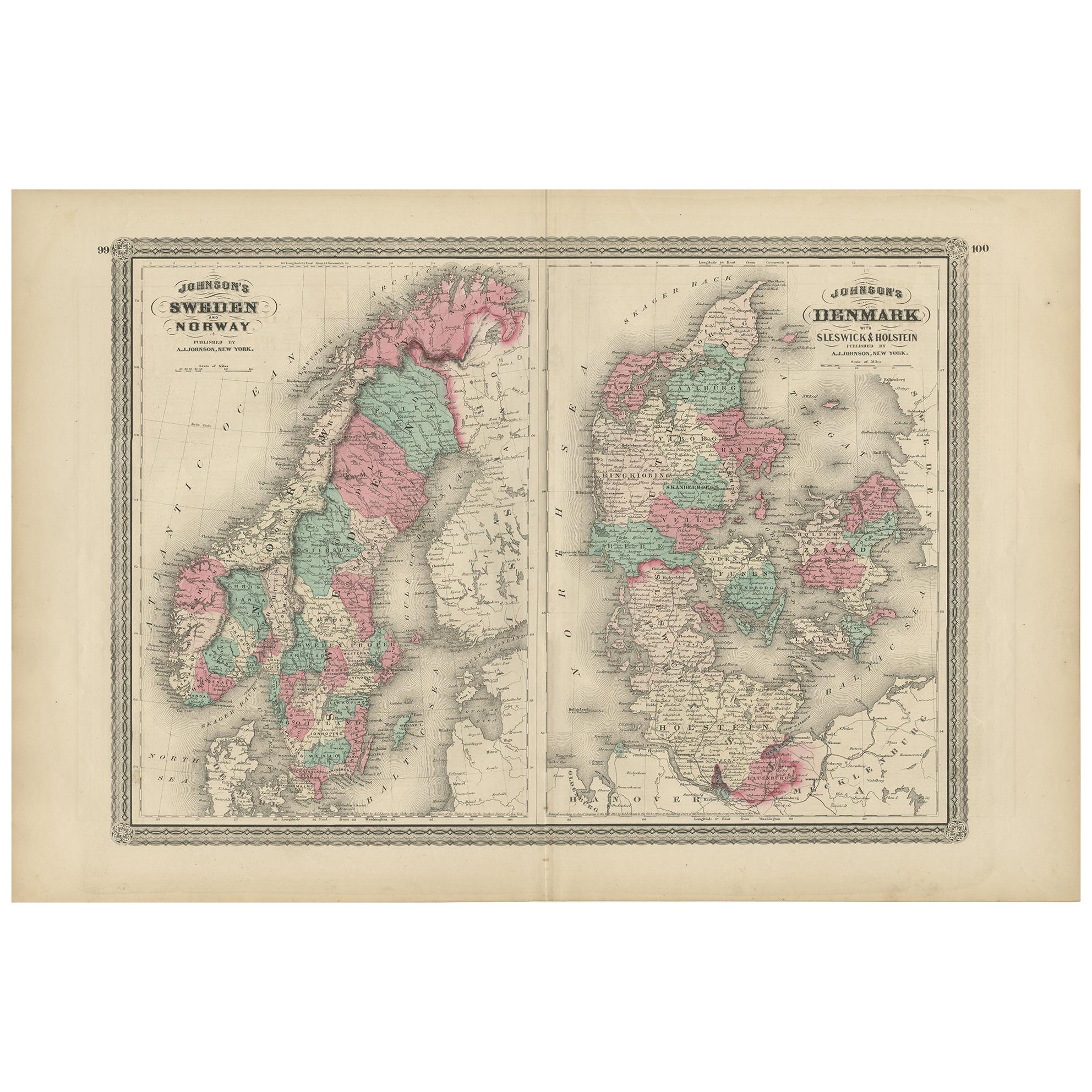
Antique Map of Sweden, Norway and Denmark by Johnson, 1872
Located in Langweer, NL
The image is an antique map, a two-page spread from "Johnson's New Illustrated Family Atlas of the World," by A.J. Johnson, dated 1872. This particular map offers a depiction of Swed...
Category
Antique Late 19th Century Maps
Materials
Paper
$240 Sale Price
20% Off
Antique Map of Denmark with Schleswig
Holstein by A
C. Black, 1870
Located in Langweer, NL
Antique map titled 'Denmark with Schleswig & Holstein'. Original antique map of Denmark with Schleswig & Holstein. This map originates from ‘Black's General Atlas of The World’. Publ...
Category
Antique Late 19th Century Maps
Materials
Paper

$126 Sale Price
40% Off
You May Also Like
Denmark. Century Atlas antique vintage map
Located in Melbourne, Victoria
'The Century Atlas. Denmark'
Original antique map, 1903.
Inset maps of 'Faroe Islands', 'Iceland' and 'Copenhagen'.
Central fold as issued. Map name and number printed on the reve...
Category
Early 20th Century Victorian More Prints
Materials
Lithograph

Original Antique Map of Sweden, Engraved by Barlow, 1806
Located in St Annes, Lancashire
Great map of Sweden
Copper-plate engraving by Barlow
Published by Brightly & Kinnersly, Bungay, Suffolk. 1806
Unframed.
Category
Antique Early 1800s English Maps
Materials
Paper

Ancient Map of Denmark and Sweden - Original Etching - 19th Century
By Giuseppe Malandrino
Located in Roma, IT
This Map of Denmark and Sweden is an etching realized by an anonymous artist.
The state of preservation of the artwork is good with some small diffused stains.
Sheet dimension: 27x...
Category
Late 19th Century Modern Figurative Prints
Materials
Etching

Large Original Vintage Map of Sweden and Norway circa 1920
Located in St Annes, Lancashire
Great map of Sweden and Norway
Original color. Good condition
Published by Alexander Gross
Unframed.
Category
Vintage 1920s English Victorian Maps
Materials
Paper

Original Antique Map of Europe, Arrowsmith, 1820
Located in St Annes, Lancashire
Great map of Europe
Drawn under the direction of Arrowsmith.
Copper-plate engraving.
Published by Longman, Hurst, Rees, Orme and Brown, 1820
...
Category
Antique 1820s English Maps
Materials
Paper

Original Antique Decorative Map of Iceland
Faroe, Fullarton, C.1870
Located in St Annes, Lancashire
Great map of Iceland and The Faroe Islands
Wonderful figural border
From the celebrated Royal Illustrated Atlas
Lithograph. Original color.
Published by Fullarton, Edinb...
Category
Antique 1870s Scottish Maps
Materials
Paper

More Ways To Browse
Corner Showcase
Iceland Antique
Icelandic Antique
Schleswig Holstein
Faroe Islands
Beni Ourain Rugs
Glass Top Wood Base Coffee Tables
T Chair
Pair Of Danish Chairs
Veneer Dining Tables
1970 Italian Armchair
Furniture Uk
House Of Denmark Table And Chairs
Louis Marble Top Side Table
Antique Russian Rugs
Baker Furniture By
For Kids
Sterling Silver Flatware Set Service For 12