Want more images or videos?
Request additional images or videos from the seller
1 of 6
Antique Map of the Dutch Antilles
Caribbean
by R. Bonne, circa 1780
Price:$306.89
$343.93List Price
About the Item
- Dimensions:Height: 18.19 in (46.2 cm)Width: 11.03 in (28 cm)Depth: 0.02 in (0.5 mm)
- Materials and Techniques:
- Period:
- Date of Manufacture:circa 1780
- Condition:Good. Please study image carefully.
- Seller Location:Langweer, NL
- Reference Number:Seller: BG-094401stDibs: LU3054310078141
About the Seller
5.0
Recognized Seller
These prestigious sellers are industry leaders and represent the highest echelon for item quality and design.
Platinum Seller
Premium sellers with a 4.7+ rating and 24-hour response times
Established in 2009
1stDibs seller since 2017
2,809 sales on 1stDibs
Typical response time: 1 hour
Authenticity Guarantee
In the unlikely event there’s an issue with an item’s authenticity, contact us within 1 year for a full refund. DetailsMoney-Back Guarantee
If your item is not as described, is damaged in transit, or does not arrive, contact us within 7 days for a full refund. Details24-Hour Cancellation
You have a 24-hour grace period in which to reconsider your purchase, with no questions asked.Vetted Professional Sellers
Our world-class sellers must adhere to strict standards for service and quality, maintaining the integrity of our listings.Price-Match Guarantee
If you find that a seller listed the same item for a lower price elsewhere, we’ll match it.Trusted Global Delivery
Our best-in-class carrier network provides specialized shipping options worldwide, including custom delivery.You May Also Like
Original Antique Map of South America. C.1780
Located in St Annes, Lancashire
Great map of South America
Copper-plate engraving
Published C.1780
Two small worm holes to left side of map
Unframed.
Category
Antique Early 1800s English Georgian Maps
Materials
Paper

The Holy Land at the Time of Jesus: A 17th Century Dutch Map by Visscher
By Nicolaes Visscher II
Located in Alamo, CA
This detailed Dutch map entitled "Het Beloofe de Landt Canaan door wandelt van onsen Salichmaecker Iesu Christo, nessens syne Apostelen" by Nicolaes Visscher was published in Amsterd...
Category
Antique Mid-17th Century Dutch Maps
Materials
Paper

$1,020 Sale Price
20% Off
H 22.75 in W 28.5 in D 1.13 in
Original Antique Map of The World by Thomas Clerk, 1817
Located in St Annes, Lancashire
Great map of The Eastern and Western Hemispheres
On 2 sheets
Copper-plate engraving
Drawn and engraved by Thomas Clerk, Edinburgh.
Published by Mackenzie And Dent, 1817
...
Category
Antique 1810s English Maps
Materials
Paper

$90 / set
Free Shipping
H 10.25 in W 8.25 in D 0.07 in
Map of the Republic of Genoa
Located in New York, NY
Framed antique hand-coloured map of the Republic of Genoa including the duchies of Mantua, Modena, and Parma.
Europe, late 18th century.
Dimension: 25...
Category
Antique Late 18th Century European Maps

Antique Map of Principality of Monaco
By Antonio Vallardi Editore
Located in Alessandria, Piemonte
ST/619 - "Old Geographical Atlas of Italy - Topographic map of ex-Principality of Monaco" -
ediz Vallardi - Milano -
A somewhat special edition ---
Category
Antique Late 19th Century Italian Other Prints
Materials
Paper

Map "Estuary- Mouth of the Thames"
Located in Alessandria, Piemonte
ST/426 - Antique French Map of the estuary of the Thames, map dated 1769 -
"Mape of the entrance of the Thames. Designed by filing of Navy cards fo...
Category
Antique Mid-18th Century French Other Prints
Materials
Paper

Antique 18th Century Map of the Province of Pensilvania
Pennsylvania State
Located in Philadelphia, PA
A fine antique of the colony of Pennsylvania.
Noted at the top of the sheet as a 'Map of the province of Pensilvania'.
This undated and anonymous map is thought to be from the Gentleman's Magazine, London, circa 1775, although the general appearance could date it to the 1760's.
The southern boundary reflects the Mason-Dixon survey (1768), the western boundary is placed just west of Pittsburgh, and the northern boundary is not marked.
The map has a number of reference points that likely refer to companion text and appear to be connected to boundaries. The western and southern boundaries are marked Q, R, S, for example. A diagonal line runs from the Susquehanna R to the Lake Erie P. A broken line marked by many letters A, B, N, O, etc., appears in the east.
There are no latitude or longitude markings, blank verso.
Framed in a shaped contemporary gilt wooden frame and matted under a cream colored matte.
Bearing an old Graham Arader Gallery...
Category
Antique 18th Century British American Colonial Maps
Materials
Paper

$1,250
H 10.25 in W 13.25 in D 0.5 in
Original Antique Map of Sweden, Engraved by Barlow, 1806
Located in St Annes, Lancashire
Great map of Sweden
Copper-plate engraving by Barlow
Published by Brightly & Kinnersly, Bungay, Suffolk. 1806
Unframed.
Category
Antique Early 1800s English Maps
Materials
Paper

Original Antique Map of China, Arrowsmith, 1820
Located in St Annes, Lancashire
Great map of China
Drawn under the direction of Arrowsmith
Copper-plate engraving
Published by Longman, Hurst, Rees, Orme and Brown, 1820
Unfr...
Category
Antique 1820s English Maps
Materials
Paper

Original Antique Map of Europe, Arrowsmith, 1820
Located in St Annes, Lancashire
Great map of Europe
Drawn under the direction of Arrowsmith.
Copper-plate engraving.
Published by Longman, Hurst, Rees, Orme and Brown, 1820
...
Category
Antique 1820s English Maps
Materials
Paper

More From This Seller
View AllAntique Map of the Antilles in the Caribbean,
1875
Located in Langweer, NL
Antique map titled 'Carte des Iles Antilles'. Large map of the Antilles. This map originates from 'Atlas de Géographie Moderne Physique et Politique' by A. Levasseur. Published, 1875.
Category
Antique Late 19th Century French Maps
Materials
Paper

$328 Sale Price
44% Off
Antique Map of Europe by R. Bonne, 1780
Located in Langweer, NL
A fine example of Rigobert Bonne and Guilleme Raynal’s 1780 map of Europe. Drawn by R. Bonne for G. Raynal’s Atlas de Toutes les Parties Connues du Globe Terrestre, Dressé pour l'His...
Category
Antique Late 18th Century French Maps
Materials
Paper

$150 Sale Price
30% Off
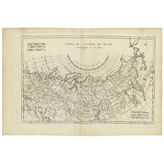
Antique Map of the Russian Empire by R. Bonne, 1780
Located in Langweer, NL
Antique map titled 'Carte de l'Empire de Russie.' Drawn by R. Bonne for G. Raynal’s Atlas de Toutes les Parties Connues du Globe Terrestre, Dressé pour l'Histoire Philosophique et Po...
Category
Antique Late 18th Century French Maps
Materials
Paper
Antique Map of the Arabian Peninsula by Bonne
c.1780
Located in Langweer, NL
Antique map titled 'Carte de l'Arabie, du Golfe Persique, et de la Mer Rouge (..)'. Original antique map of the Arabian Peninsula, including the horn...
Category
Antique Late 18th Century Maps
Materials
Paper

$525 Sale Price
20% Off
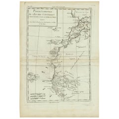
Antique Map of West Africa by R. Bonne, 1780
Located in Langweer, NL
Antique map titled 'Partie Occidentale De L'Ancien Continent Depuis Lisbonne Jusqua La Riviere De Sierra Leona Avec L'Isle de Madere, les Isles Canaries et celles Du Cap Verd'. Parts...
Category
Antique Late 18th Century French Maps
Materials
Paper
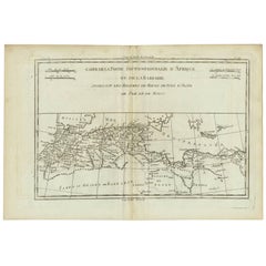
Antique Map of Northern Africa "Barbary Coast" by R. Bonne, circa 1780
Located in Langweer, NL
A fine example of Rigobert Bonne and Guilleme Raynal’s 1780 map of northwestern Africa or the Barbary Coast. Includes the modern day countries of Morocco, Algeria, Tunisia, Libya, and parts of adjacent Spain, Italy and Greece. This map was made in response to European interest in the region due to coastal attacks and incursions by the Barbary Pirates...
Category
Antique Late 18th Century French Maps
Materials
Paper