Items Similar to Antique Map of Dutch Colonies in the Caribbean
Suriname by Dornseiffen, 1884
Want more images or videos?
Request additional images or videos from the seller
1 of 15
Antique Map of Dutch Colonies in the Caribbean
Suriname by Dornseiffen, 1884
$466.69
£348.57
€390
CA$642.95
A$700.70
CHF 371.05
MX$8,416.19
NOK 4,697.61
SEK 4,318.99
DKK 2,971.13
About the Item
Antique Map of Dutch Colonies in the Caribbean
Suriname - Dornseiffen 1884
This rare and historically important antique map depicts the Dutch colonial possessions in the Americas, focusing on Suriname and the Dutch Caribbean islands including Curaçao, Aruba, Bonaire, and the Lesser Antilles. Titled “De Nederlandsche Bezittingen in Amerika,” this multi-panel composition was designed by J. Dornseiffen and published in Amsterdam by Seyffardt’s Boekhandel in 1884 as part of the official late-19th-century Dutch colonial atlas series.
The sheet is composed of several coordinated maps. The large central map shows the full extent of the colony of Suriname in detailed riverine and plantation-based geography, with plantation zones, indigenous areas, and river systems carefully engraved. The tall right-hand panel focuses specifically on the Suriname River, illustrating its winding course and strategic importance for transport and trade. It also shows the gold fields areas. The upper panels depict the Dutch Caribbean island groups, including Curaçao with Aruba and Bonaire, and the Lesser Antilles with St. Eustatius, Saba, St. Martin, and surrounding islands in the Atlantic Ocean. Original hand coloring highlights coastlines and colonial boundaries throughout.
Historically, these territories formed the backbone of Dutch imperial presence in the Americas. Suriname was a major plantation colony producing sugar, coffee, and cacao through enslaved labor, while the Caribbean islands functioned as key naval, trading, and transshipment hubs within the Atlantic world. By 1884, when Dornseiffen produced this map, slavery had been abolished but the colonial plantation economy and global trade networks remained firmly intact. This map visually documents the mature phase of Dutch overseas empire in the Western Hemisphere.
Visually, this is a highly attractive and intellectually rich composition. The structured grid of maps, delicate pastel hand coloring, fine line engraving, and generous sea spaces give the sheet a refined balance between scientific authority and decorative elegance. It works beautifully as a standalone statement piece or as part of a broader Dutch colonial map collection.
This sheet is increasingly sought after by collectors of Suriname history, Caribbean cartography, Atlantic world studies, colonial plantation economies, and Dutch imperial expansion. It also pairs exceptionally well with Dornseiffen’s East Indies series for a complete global presentation of Dutch colonial geography.
Condition report: Good antique condition. Light overall age toning consistent with 19th-century paper. Scattered foxing visible, particularly in the margins and open sea areas. Clear plate impressions present. Full margins preserved. No major tears or losses observed.
Framing tips: This map displays beautifully with a wide off-white or warm ivory mat and a dark walnut, ebonized, or antique gilt frame. Museum glass is recommended for UV protection and optimal clarity of the fine engraving. Ideal for libraries, studies, or refined contemporary interiors.
Technique: Hand-colored lithograph
Maker: J. Dornseiffen, Amsterdam, 1884 (published by Seyffardt’s Boekhandel)
- Dimensions:Height: 15.36 in (39 cm)Width: 19.1 in (48.5 cm)Depth: 0.01 in (0.2 mm)
- Materials and Techniques:
- Place of Origin:
- Period:
- Date of Manufacture:1884
- Condition:Condition report: Good antique condition. Light general age toning consistent with 19th-century paper. Scattered foxing visible, mainly in the open sea areas and margins. Clear plate impressions present. Full margins preserved.
- Seller Location:Langweer, NL
- Reference Number:Seller: BG-14172-151stDibs: LU3054347873042
About the Seller
5.0
Recognized Seller
These prestigious sellers are industry leaders and represent the highest echelon for item quality and design.
Platinum Seller
Premium sellers with a 4.7+ rating and 24-hour response times
Established in 2009
1stDibs seller since 2017
2,788 sales on 1stDibs
Typical response time: <1 hour
- ShippingRetrieving quote...Shipping from: Langweer, Netherlands
- Return Policy
More From This Seller
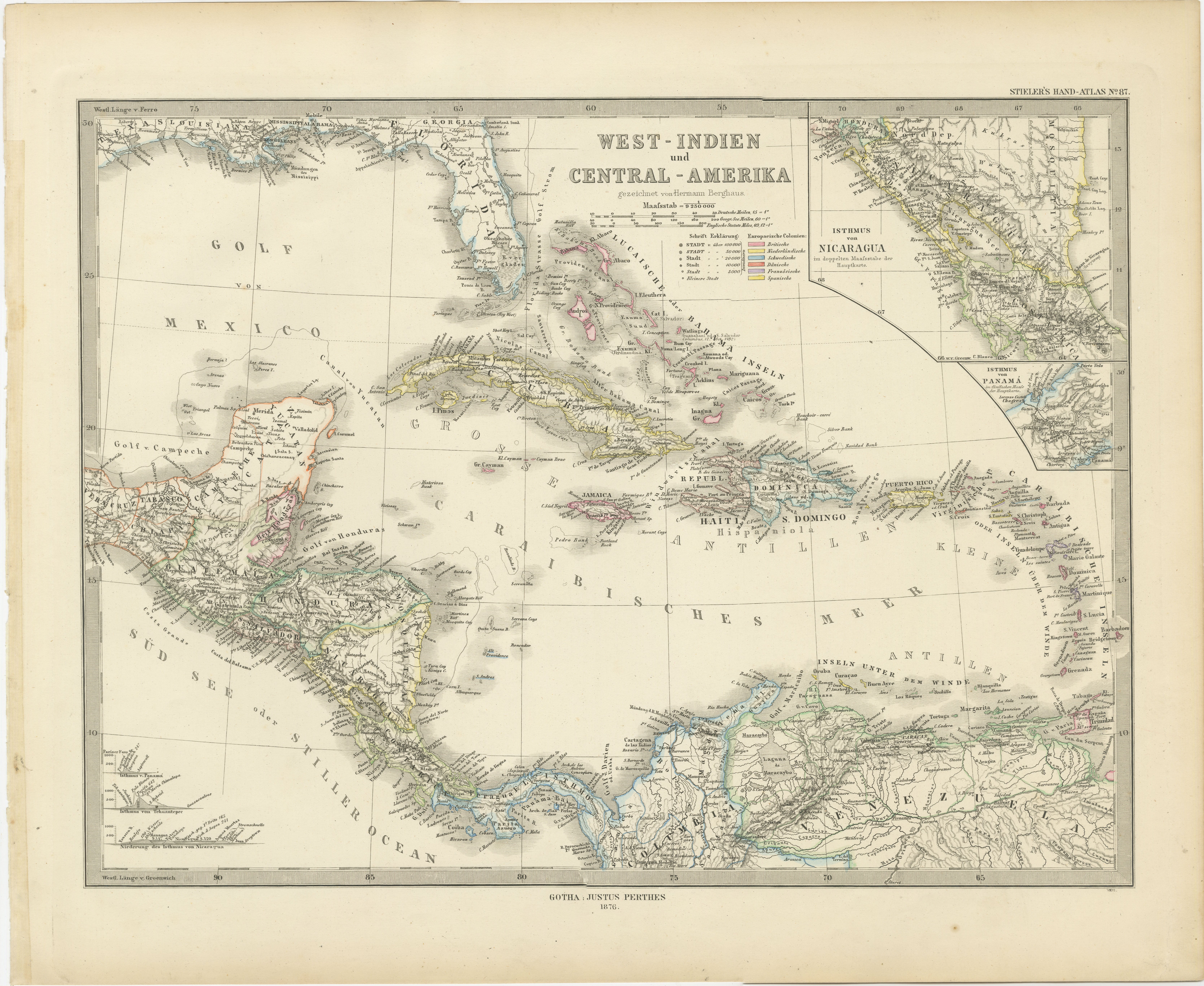
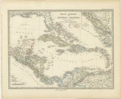
View All1880 Map of the Caribbean and Central America by Adolf Stieler
Located in Langweer, NL
This is a detailed map titled "West-Indien und Central-Amerika," created by Adolf Stieler and published in Gotha in 1880. The map covers the Caribbean islands and the Central America...
Category
Antique 1880s Maps
Materials
Paper
$277 Sale Price
20% Off
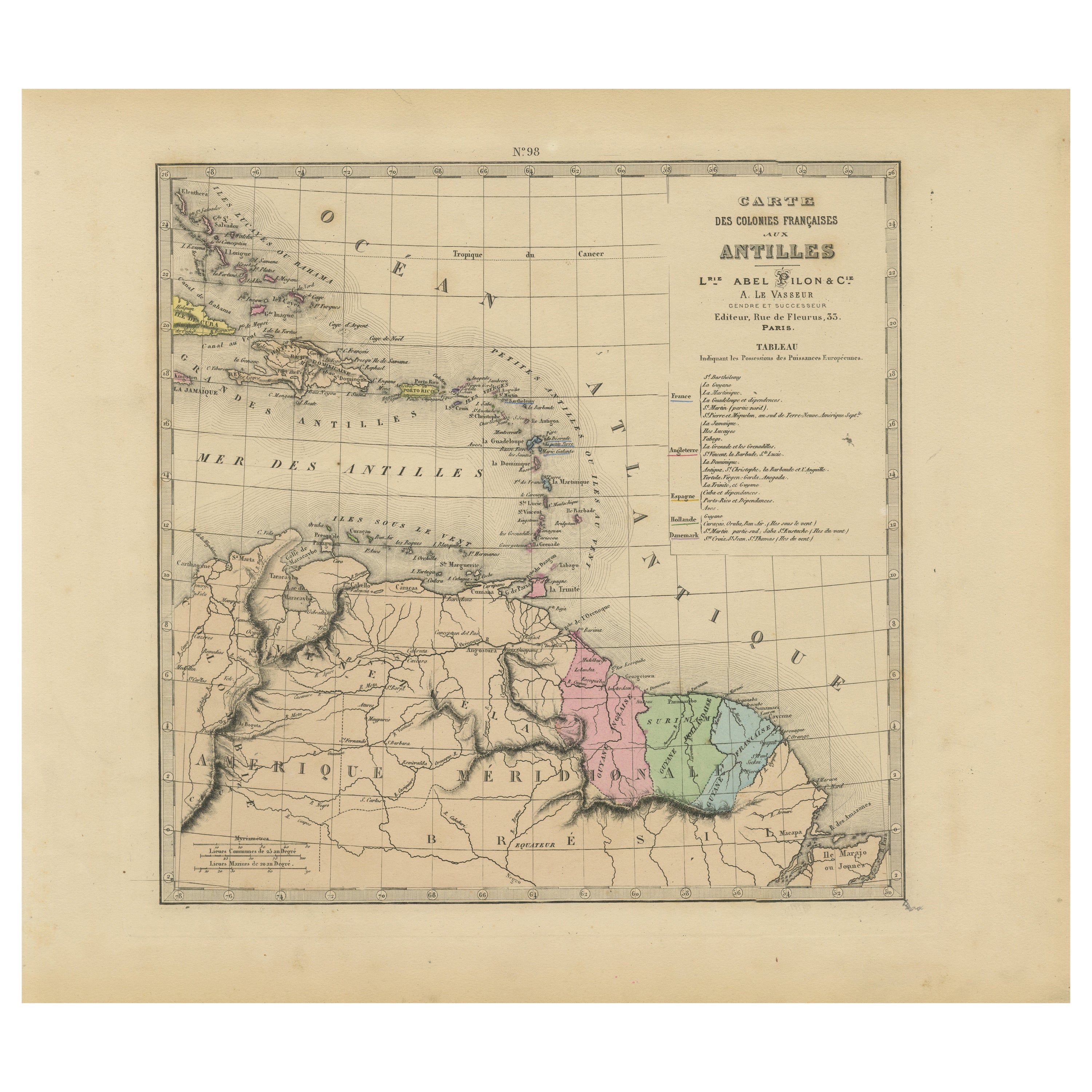
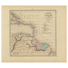
Authentique Map by Pilon of The French Colonies in The West Indies, 1876
Located in Langweer, NL
The 1876 map titled "Carte des Colonies Françaises aux Antilles" represents a significant contribution to cartography within the "Grand Atlas Départemental de la France de L'Algérie ...
Category
Antique Late 19th Century Maps
Materials
Paper
$229 Sale Price
20% Off
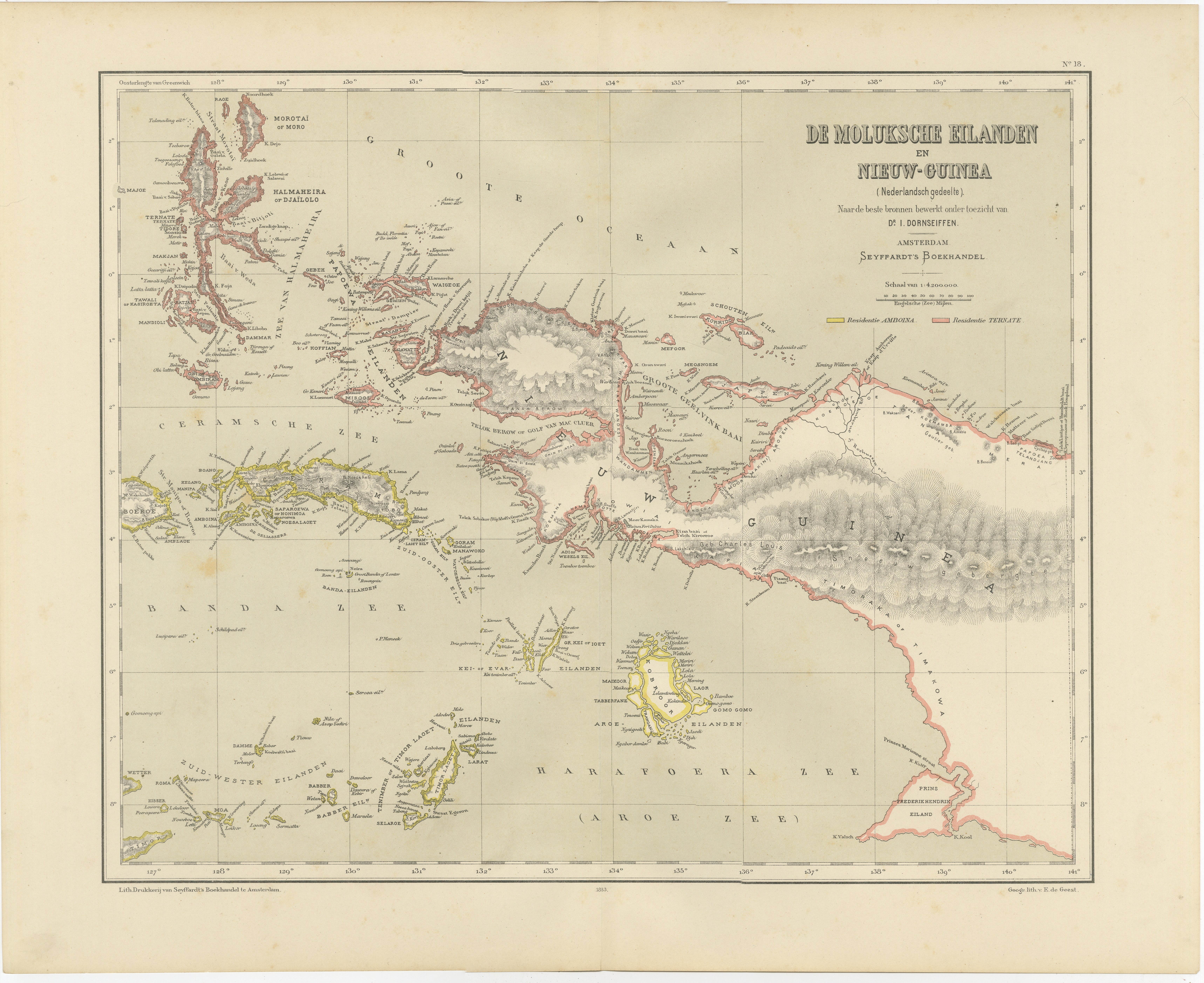
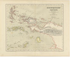
Antique Colonial Dutch Map of the Moluccas
New Guinea by Dornseiffen, 1884
Located in Langweer, NL
Antique Dutch Map of the Moluccas & New Guinea by Dornseiffen 1884 Indonesia
This decorative antique map depicts the Moluccan Islands (Spice Islands) and the western portion of New ...
Category
Antique 1880s Dutch Maps
Materials
Paper
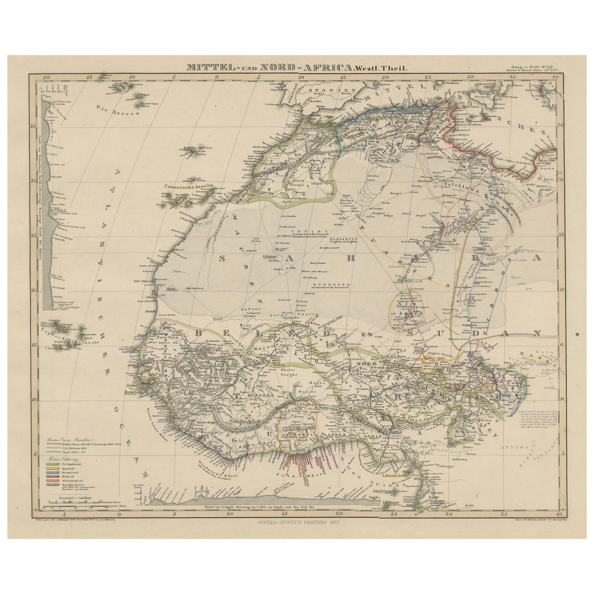
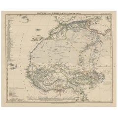
Antique Map of West and Central Africa – Stieler Atlas, Justus Perthes 1857
Located in Langweer, NL
Antique Map of West and Central Africa – Stieler Atlas, Justus Perthes 1857
This finely engraved map titled "Mittel- und Nord-Africa. Westl. Theil." was published in 1857 by Justus ...
Category
Antique Mid-19th Century German Maps
Materials
Paper
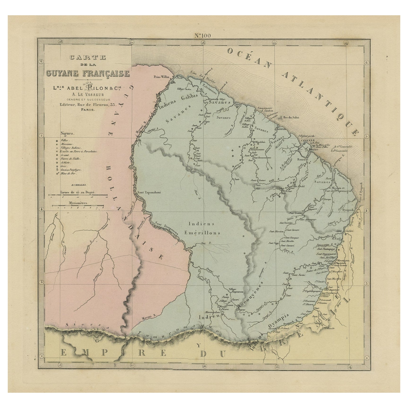
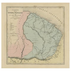
Antique Engraved Map with Original Hand Colour of French Guiana, 1876
Located in Langweer, NL
The 1876 map of French Guiana from the "Grand Atlas Départemental de la France de L'Algérie et des colonies" by H. Fisquet, published by A. Le Vasseur in Paris, is a significant piec...
Category
Antique Late 19th Century Maps
Materials
Paper
$268 Sale Price
20% Off
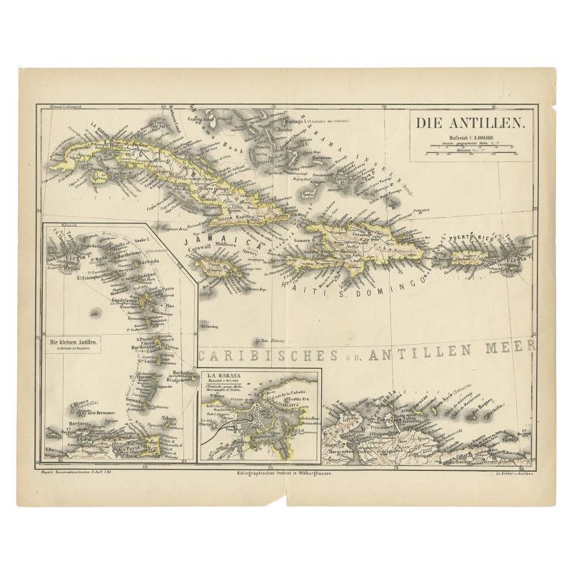
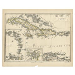
Antique Map of the Antilles by Meyer, 1878
Located in Langweer, NL
Antique map titled 'Die Antillen'. Old map of the Antilles, it shows Jamaica, Puerto Rico, the Bahamas and Cuba. With inset maps of the Lesser Antilles and Havana. This map originate...
Category
Antique 19th Century Maps
Materials
Paper
$81 Sale Price
20% Off
You May Also Like
Original Antique Map of Central America / Florida, Arrowsmith, 1820
Located in St Annes, Lancashire
Great map of Central America.
Drawn under the direction of Arrowsmith.
Copper-plate engraving.
Published by Longman, Hurst, Rees, Orme and Brown, 1820
Unframed.
Category
Antique 1820s English Maps
Materials
Paper

South America, Eastern Part. Century Atlas antique vintage map
Located in Melbourne, Victoria
'The Century Atlas. South America. Eastern Part'
Original antique map, 1903.
Inset map 'Rio de Janeiro and Vicinity'.
Central fold as issued. Map name and number printed on the rev...
Category
Early 20th Century Victorian More Prints
Materials
Lithograph

South America, North-West Part. Century Atlas antique vintage map
Located in Melbourne, Victoria
'The Century Atlas. South America, North-West Part'
Original antique map, 1903.
Central fold as issued. Map name and number printed on the reverse corners.
Sheet 40cm by 29.5cm.
Category
Early 20th Century Victorian More Prints
Materials
Lithograph

Original Antique Decorative Map of South America-West Coast, Fullarton, C.1870
Located in St Annes, Lancashire
Great map of Chili, Peru and part of Bolivia
Wonderful figural border
From the celebrated Royal Illustrated Atlas
Lithograph. Original color.
Published by Fullarton, Edi...
Category
Antique 1870s Scottish Maps
Materials
Paper

The Netherlands (Holland), Belgium and Luxemburg. Century Atlas antique map
Located in Melbourne, Victoria
'The Century Atlas. The Netherlands (Holland), Belgium and Luxemburg.'
Original antique map, 1903.
Inset maps of 'Amsterdam' and 'Brussels'.
Central fold as issued. Map name and num...
Category
Early 20th Century Victorian More Prints
Materials
Lithograph

Extremely Large Hand-Drawn Manuscript Map of Surinam, 1830, History of Slavery
Located in Amsterdam, NL
A unique large hand-drawn map of Surinam by Albrecht Helmut Hiemcke (German, 1760-1839)
?
'Colonie Surinaame', 1830
A large hand-drawn and coloured map of the colony of Suri...
Category
Antique Mid-19th Century Surinamer Maps
Materials
Paper
