Items Similar to Antique Map of Eastern Europe – Russia, Ottoman Empire
Greece, 1868


Want more images or videos?
Request additional images or videos from the seller
1 of 10
Antique Map of Eastern Europe – Russia, Ottoman Empire
Greece, 1868
$466.73
£349.40
€390
CA$642.51
A$702.39
CHF 371.59
MX$8,405.20
NOK 4,728.01
SEK 4,328.01
DKK 2,971.32
About the Item
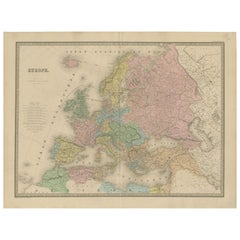
Antique Map of Eastern Europe – Russia, Ottoman Empire and Greece by Andriveau-Goujon, 1868
This detailed antique map titled “Carte de l’Europe Orientale, la Russie d’Europe, l’Empire Ottoman et la Grèce” was published in Paris in 1868 by E. Andriveau-Goujon. Issued as plate number 31 from the Atlas Universel, the map presents the eastern portion of the European continent at a time of significant geopolitical tension between the Russian and Ottoman Empires.
The map extends from the Gulf of Finland and the Baltic region in the north down to the northern part of the Mediterranean, including the Black Sea and parts of Asia Minor. It spans westward from present-day Poland, Hungary, and Austria, all the way east across Ukraine and into western Russia. The territories are hand-colored to distinguish the dominant empires and regions: the Russian Empire in green, the Ottoman-controlled Balkans in brown, and Greece in pale pink.
Major cities and trade centers are clearly labeled, including Saint Petersburg, Moscow, Kiev, Warsaw, Odessa, Bucharest, Constantinople (Istanbul), Athens, and Thessaloniki. Extensive road and river networks are finely engraved, and important geographic features such as the Carpathian and Balkan mountain ranges, the Danube River, and the Black Sea are prominently shown.
The map reflects a tense period in 19th-century Europe, with the weakening Ottoman grip on the Balkans and the growing influence of Russia in southeastern Europe. This was also a time of national awakenings and independence movements, particularly in the Balkans and among the Slavic peoples. The map offers valuable insight into the imperial boundaries and regional divisions just a decade before the Russo-Turkish War (1877–78) and the further fragmentation of Ottoman control in Europe.
Condition: Very good condition. Slight toning to edges and minimal foxing in margins. Strong plate impression with original pastel hand coloring. Original centerfold as issued. Plate number 31 at top right.
Framing tips: A dark wood or antique gold frame with an ivory mat is ideal. A pale green or rust-colored inner mat can subtly draw out the imperial colors and enhance the period look.
Technique: Engraving with original hand coloring
Maker: E. Andriveau-Goujon, Paris, 1868
- Dimensions:Height: 27.64 in (70.2 cm)Width: 20.91 in (53.1 cm)Depth: 0.01 in (0.2 mm)
- Materials and Techniques:Paper,Engraved
- Place of Origin:
- Period:
- Date of Manufacture:1868
- Condition:Condition: Very good condition. Slight toning to edges and minimal foxing in margins. Strong plate impression with original pastel hand coloring. Original centerfold as issued. Plate number 31 at top right.
- Seller Location:Langweer, NL
- Reference Number:Seller: BG-14099-101stDibs: LU3054346185562
About the Seller
5.0
Recognized Seller
These prestigious sellers are industry leaders and represent the highest echelon for item quality and design.
Platinum Seller
Premium sellers with a 4.7+ rating and 24-hour response times
Established in 2009
1stDibs seller since 2017
2,792 sales on 1stDibs
Typical response time: <1 hour
- ShippingRetrieving quote...Shipping from: Langweer, Netherlands
- Return Policy
More From This Seller
View AllAntique Map of Russia in Europe, 1842
Located in Langweer, NL
Antique map titled 'Carte de la Russie d'Europe'. Map of Russia in Europe. This map originates from 'Atlas universel de géographie ancienne et moderne (....
Category
Antique 19th Century Maps
Materials
Paper

$228 Sale Price
20% Off
Antique Map of Russia in Europe by Levasseur,
1875
Located in Langweer, NL
Antique map titled 'Carte générale de la Russie d'Europe (..)'. Large map of Russia in Europe. This map originates from 'Atlas de Géographie Moderne Physique et Politique' by A. Leva...
Category
Antique Late 19th Century Maps
Materials
Paper

$335 Sale Price
20% Off
Antique Map of Russia
in Europe
by W.
A.K. Johnston, circa 1850
By W.
A.K. Johnston
Located in Langweer, NL
Antique Map: Russia in Europe by W. & A.K. Johnston, Circa 1850
This highly detailed antique map, titled *Russia in Europe,* was created by the esteemed Scottish cartographers W. ...
Category
Antique Mid-19th Century Maps
Materials
Paper

$229 Sale Price
34% Off
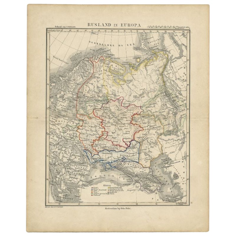
Antique Map of Russia in Europe by Petri, c.1873
Located in Langweer, NL
Antique map titled 'Rusland in Europa'. Old map depicting Russia in Europe. This map originates from 'School-Atlas van alle Deelen der Aarde'. Artists and Engravers: Published by O. ...
Category
Antique 19th Century Maps
Materials
Paper
$92 Sale Price
20% Off
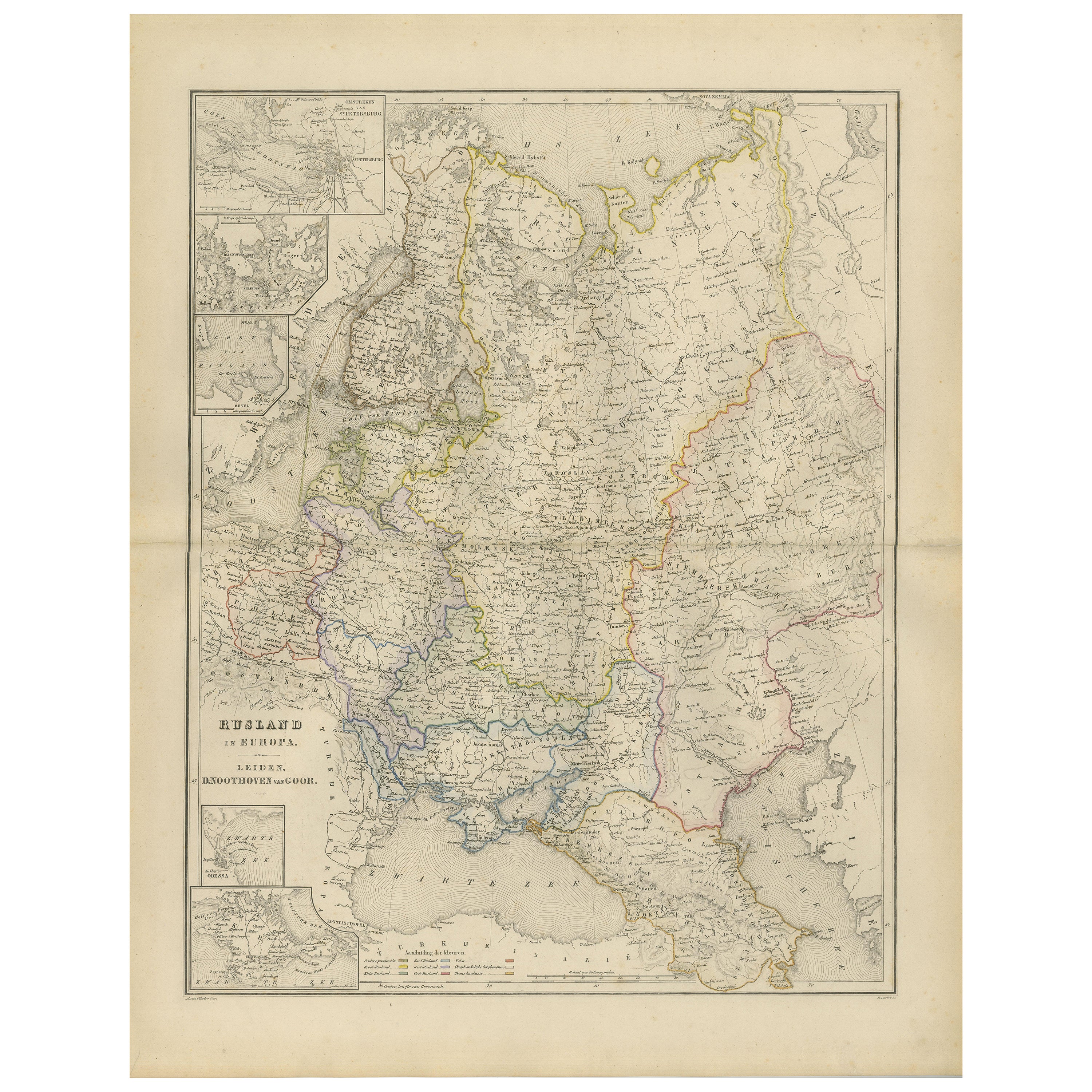
European Russia Map with Saint Petersburg Inset – Nieuwe Hand-Atlas, 1876
Located in Langweer, NL
European Russia Map with Saint Petersburg Inset – Nieuwe Hand-Atlas, 1876
This finely engraved 19th-century map titled “Rusland in Europa” presents the western portion of the Russia...
Category
Antique 1870s Dutch Maps
Materials
Paper
Antique Map of Europe – Political Divisions by Andriveau-Goujon, Paris 1861
Located in Langweer, NL
Antique Map of Europe – Political Divisions by Andriveau-Goujon, Paris 1861
This beautifully engraved and hand-colored antique map of Europe was published in 1861 by the Parisian ca...
Category
Antique Mid-19th Century French Maps
Materials
Paper
You May Also Like
1849 Map of "Europaische Russland",
Meyer Map of European Russia
, Ric. R017
Located in Norton, MA
1849 Map of
"Europaische Russland"
( Meyer Map of European Russia)
Ric.r017
A lovely map of European Russia dating to 1849 by Joseph Meyer. It covers the European portions of...
Category
Antique 19th Century Unknown Maps
Materials
Paper

Russia, Western and Southern Part. Century Atlas antique vintage map
Located in Melbourne, Victoria
'The Century Atlas. Russia, Western and Southern Part'
Original antique map, 1903.
Inset map tilted 'St Petersburg and Environs'.
Central fold as issued. Map name and number printe...
Category
Early 20th Century Victorian More Prints
Materials
Lithograph

Russia in Europe with Poland and Finland. Century Atlas antique vintage map
Located in Melbourne, Victoria
'The Century Atlas. Russia in Europe with Poland and Finland'
Original antique map, 1903.
Central fold as issued. Map name and number printed on the reverse corners.
Sheet 40cm by ...
Category
Early 20th Century Victorian More Prints
Materials
Lithograph

1853 Map of "Russia in Europe Including Poland" Ric.r016
Located in Norton, MA
Description
Russia in Europe incl. Poland by J Wyld c.1853
Hand coloured steel engraving
Dimension: Paper: 25 cm W x 33 cm H ; Sight: 22 cm W x 28 cm H
Condition: Good ...
Category
Antique 19th Century Unknown Maps
Materials
Paper

Austria-Hungary, Western Part. Century Atlas antique vintage map
Located in Melbourne, Victoria
'The Century Atlas. Austria-Hungary, Western Part'
Original antique map, 1903.
Central fold as issued. Map name and number printed on the reverse corners.
Sheet 40cm by 29.5cm.
Category
Early 20th Century Victorian More Prints
Materials
Lithograph

Map of Eastern Roman Empire -Vintage Offset Print - Early 20th Century
Located in Roma, IT
This map of Eastern Roman Empire is a vintage offset print realized in the early 20th Century.
The state of preservation of the artwork is aged with dif...
Category
Early 20th Century Figurative Prints
Materials
Offset

More Ways To Browse
1868 Furniture
Istanbul Antique
Antique French Ottoman
Eastern European Furniture
Eastern European Antiques
Pair Of Danish Chairs
Veneer Dining Tables
1970 Italian Armchair
Furniture Uk
House Of Denmark Table And Chairs
Louis Marble Top Side Table
Antique Russian Rugs
Baker Furniture By
For Kids
Sterling Silver Flatware Set Service For 12
Tufted Bar
Pair Of French Antique Armchairs
1970s Brass Glass Coffee Table