Items Similar to Antique Map of Eastern Germany, Bohemia, Moravia
Silesia – 1858

Video Loading
Want more images or videos?
Request additional images or videos from the seller
1 of 11
Antique Map of Eastern Germany, Bohemia, Moravia
Silesia – 1858
$524.30
£390.53
€440
CA$722.01
A$785.88
CHF 416.41
MX$9,451.46
NOK 5,294.58
SEK 4,851.89
DKK 3,352.51
About the Item
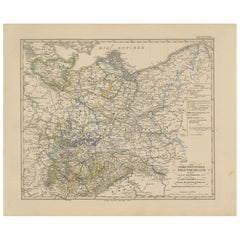
Antique Map of Eastern Germany, Bohemia, Moravia
Silesia – 1858
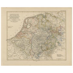
Detailed 19th-century engraved map titled "Östliches Deutschland mit Böhmen, Mähren und Schlesien" (Eastern Germany with Bohemia, Moravia, and Silesia), published by Justus Perthes in Gotha in 1858. This finely executed copperplate engraving presents a richly detailed view of the political and geographic landscape of Central Europe in the mid-19th century.
The map spans modern-day eastern Germany, the Czech Republic, and parts of southwestern Poland, highlighting the historic regions of Bohemia (Böhmen), Moravia (Mähren), and Silesia (Schlesien). Provincial and district boundaries are outlined in hand-applied colors, distinguishing the territories of Prussia, the Austrian Empire, and the German Confederation.
Major cities such as Prague, Breslau (Wrocław), Brünn (Brno), Olmütz (Olomouc), and Dresden are prominently marked, along with hundreds of towns, roads, rivers, and fortifications. The rich topographical engraving conveys the mountainous terrain of the Ore Mountains (Erzgebirge) and Sudetenland, and the forested interior of Bohemia.
An elevation profile at the bottom of the map illustrates the varying altitudes across the depicted regions, providing valuable context to the landscape. A detailed legend identifies political divisions, mountain ranges, and road categories, enhancing the map's function as a historical and geographical reference.
This map captures the complex political landscape of Central Europe in a time of rising nationalism and shifting allegiances—prior to the Austro-Prussian War of 1866 and long before the redrawing of borders after the world wars. It is a valuable and decorative piece for collectors interested in the history of the Habsburg Empire, Prussia, and Central European geography.
Condition report:
Very good condition. Some light toning to outer margins. Hand-coloring well preserved and crisp. No tears or repairs. Image clean and finely detailed. Please inspect closely.
Framing tips:
A classic dark wood frame (ebony or walnut) with a warm ivory or parchment mat would suit this map well. A fine red or gold accent line may enhance the borders of Bohemia and Silesia. Ideal for historical interiors, libraries, or academic collections.
Technique: Copperplate engraving with original hand-coloring
Maker: Justus Perthes, Gotha, 1858
- Dimensions:Height: 14.77 in (37.5 cm)Width: 17.88 in (45.4 cm)Depth: 0.01 in (0.2 mm)
- Materials and Techniques:Paper,Engraved
- Place of Origin:
- Period:
- Date of Manufacture:1858
- Condition:Very good condition. Some light toning to outer margins. Hand-coloring well preserved and crisp. No tears or repairs. Image clean and finely detailed. Please inspect closely.
- Seller Location:Langweer, NL
- Reference Number:Seller: BG-05552-311stDibs: LU3054346118242
About the Seller
5.0
Recognized Seller
These prestigious sellers are industry leaders and represent the highest echelon for item quality and design.
Platinum Seller
Premium sellers with a 4.7+ rating and 24-hour response times
Established in 2009
1stDibs seller since 2017
2,824 sales on 1stDibs
Typical response time: 1 hour
- ShippingRetrieving quote...Shipping from: Langweer, Netherlands
- Return Policy
More From This Seller
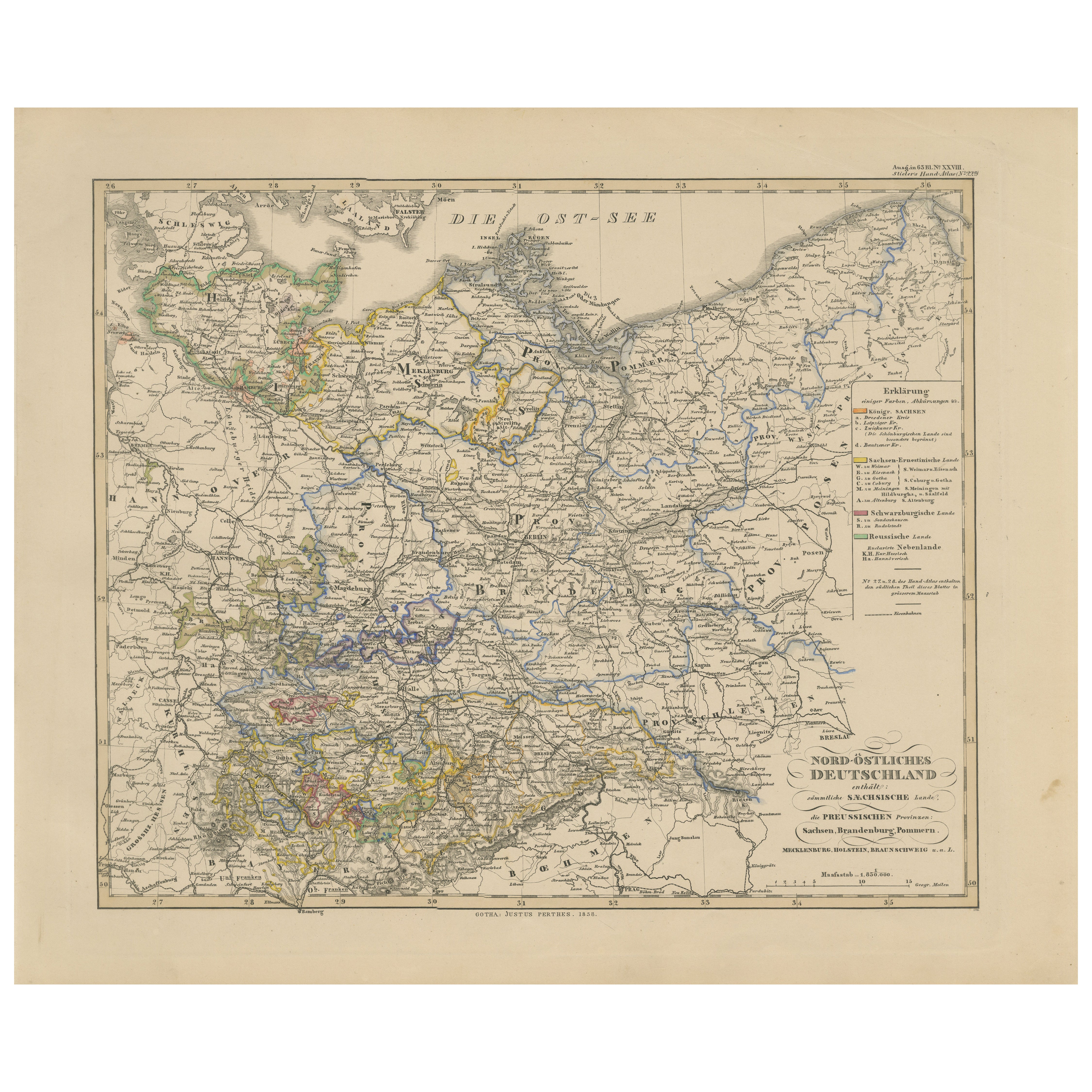
View AllAntique Map of Northeastern Germany – Saxon
Prussian States, 1858
Located in Langweer, NL
Antique Map of Northeastern Germany – Saxon & Prussian States, 1858
Detailed and finely engraved map titled "Nord-Östliches Deutschland enthaltend die Sächsischen Länder und die Pre...
Category
Antique Mid-19th Century German Maps
Materials
Paper
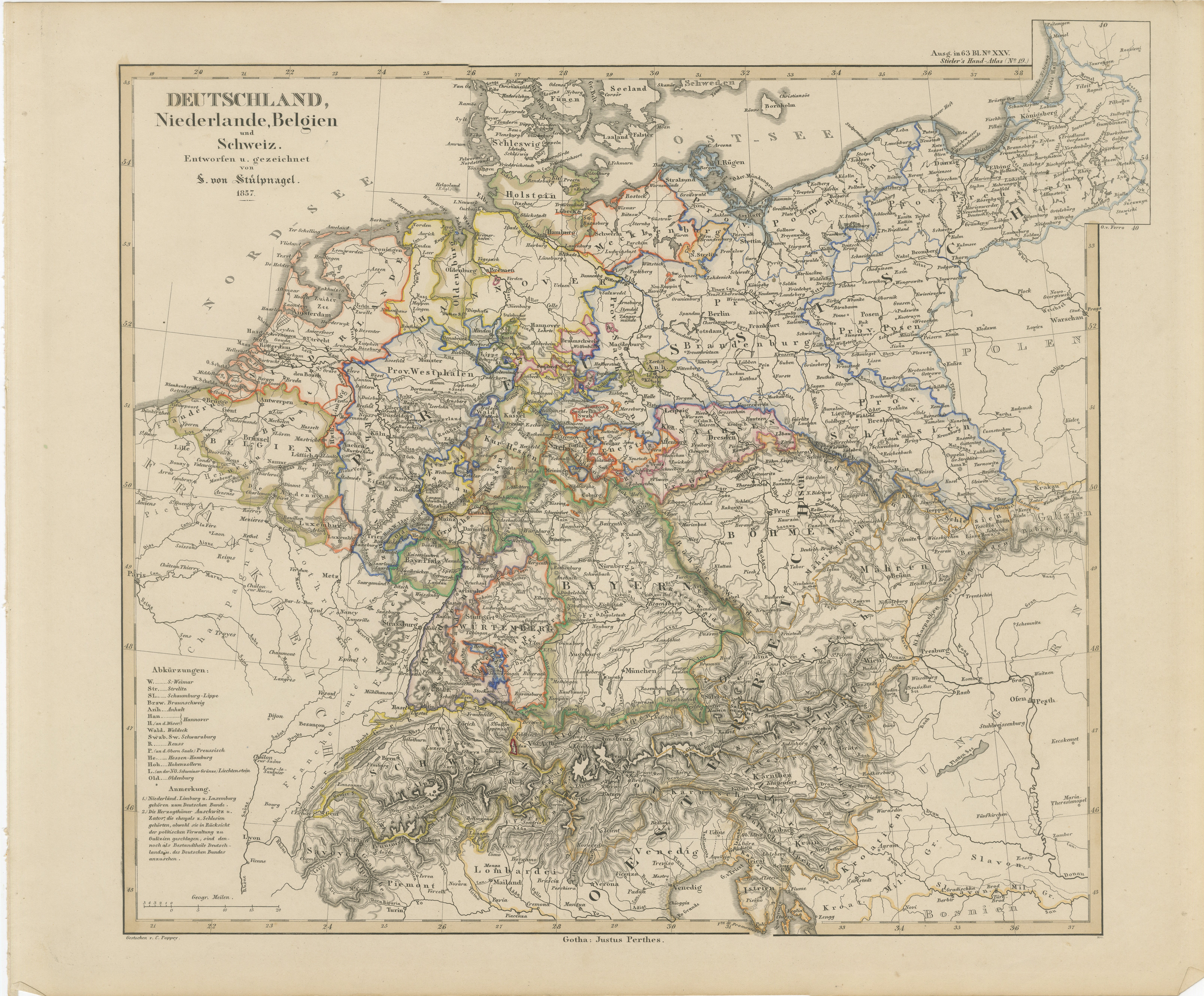
Antique Map of Germany, Netherlands, Belgium
Switzerland – Stülpnagel, 1857
Located in Langweer, NL
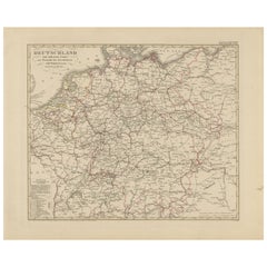
Antique Map of Germany, Netherlands, Belgium & Switzerland – Stülpnagel, 1857
Fine mid-19th century map of Central Europe titled "Deutschland, Niederlande, Belgien, Schweiz", drawn ...
Category
Antique Mid-19th Century German Maps
Materials
Paper

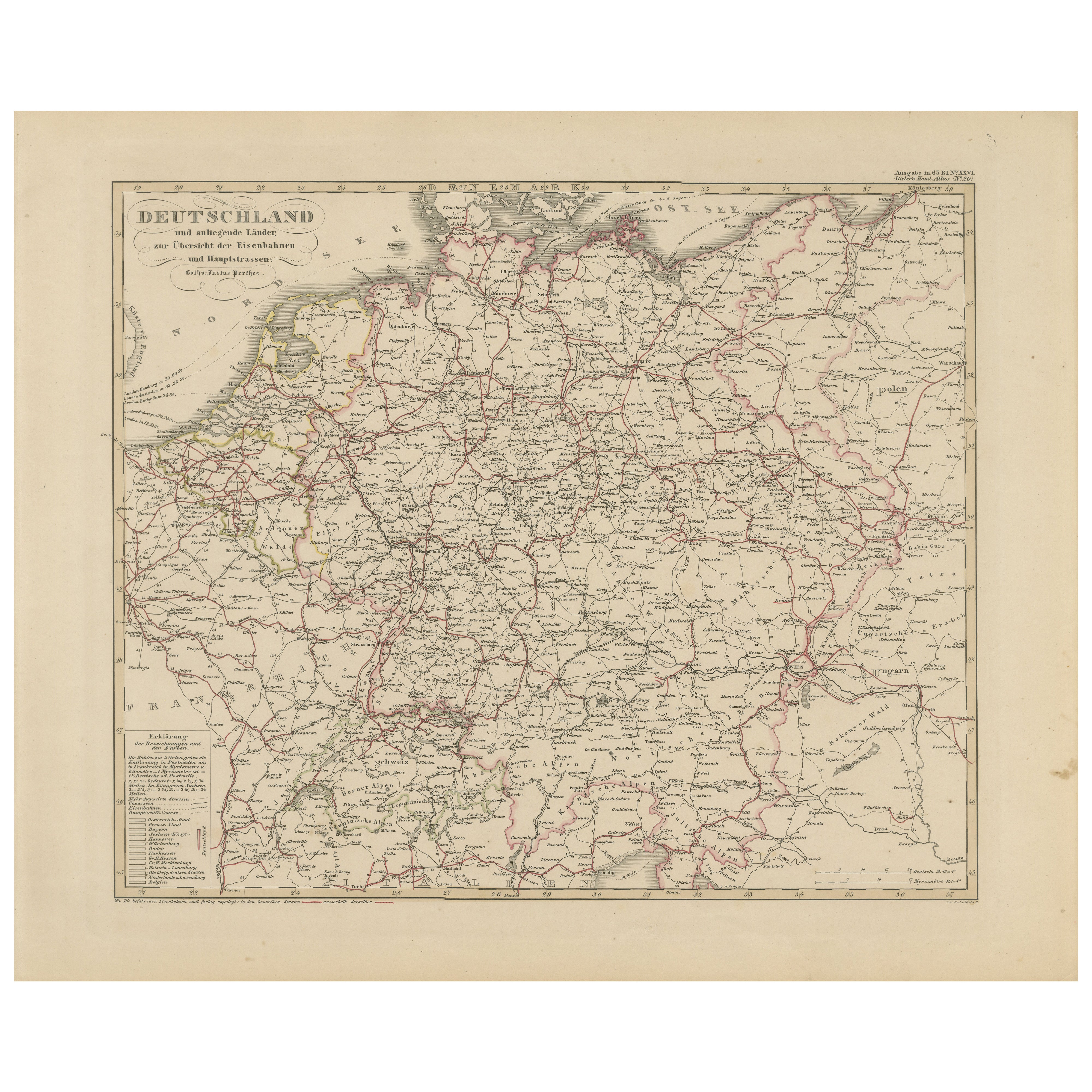
Antique Map of Germany
Railways – Transport Network Overview, 1857
Located in Langweer, NL
Antique Map of Germany & Railways – Transport Network Overview, 1857
Striking 19th-century map titled "Deutschland und angränzende Länder zur Übersicht der Eisenbahnen und Hauptstra...
Category
Antique Mid-19th Century German Maps
Materials
Paper
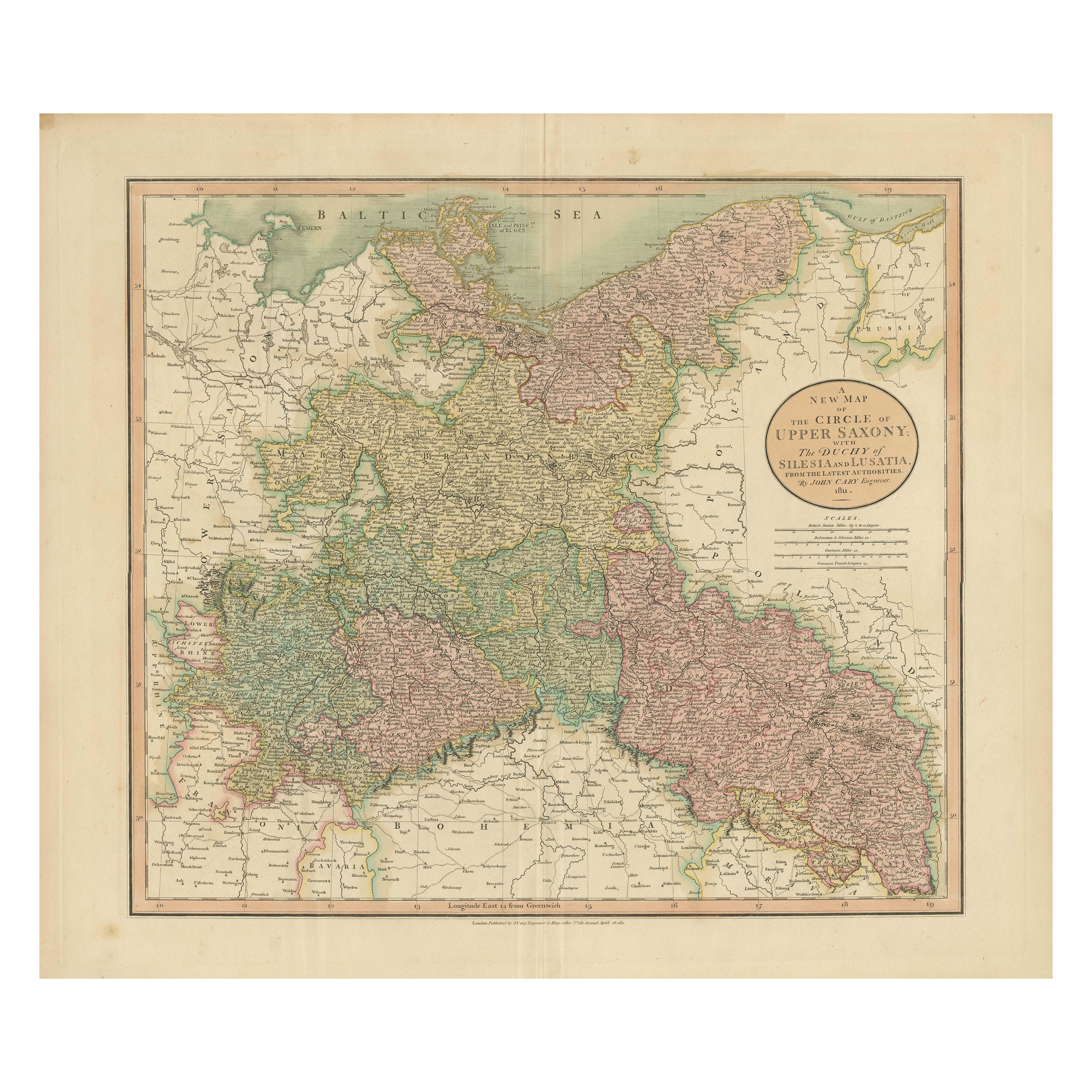
Antique Map of the Eastern Part of Germany, with Parts of Poland and Slovakia
Located in Langweer, NL
Antique map titled 'A New Map of the Circle of Upper Saxony: with the Duchy of Silesi and Lusatia, from the latest authorities'. Clear and accurate map of what is now the eastern par...
Category
Antique Early 19th Century Maps
Materials
Paper
$419 Sale Price
20% Off
Antique Map of Prussia, Hanover, Netherlands
Belgium – 1858
Located in Langweer, NL
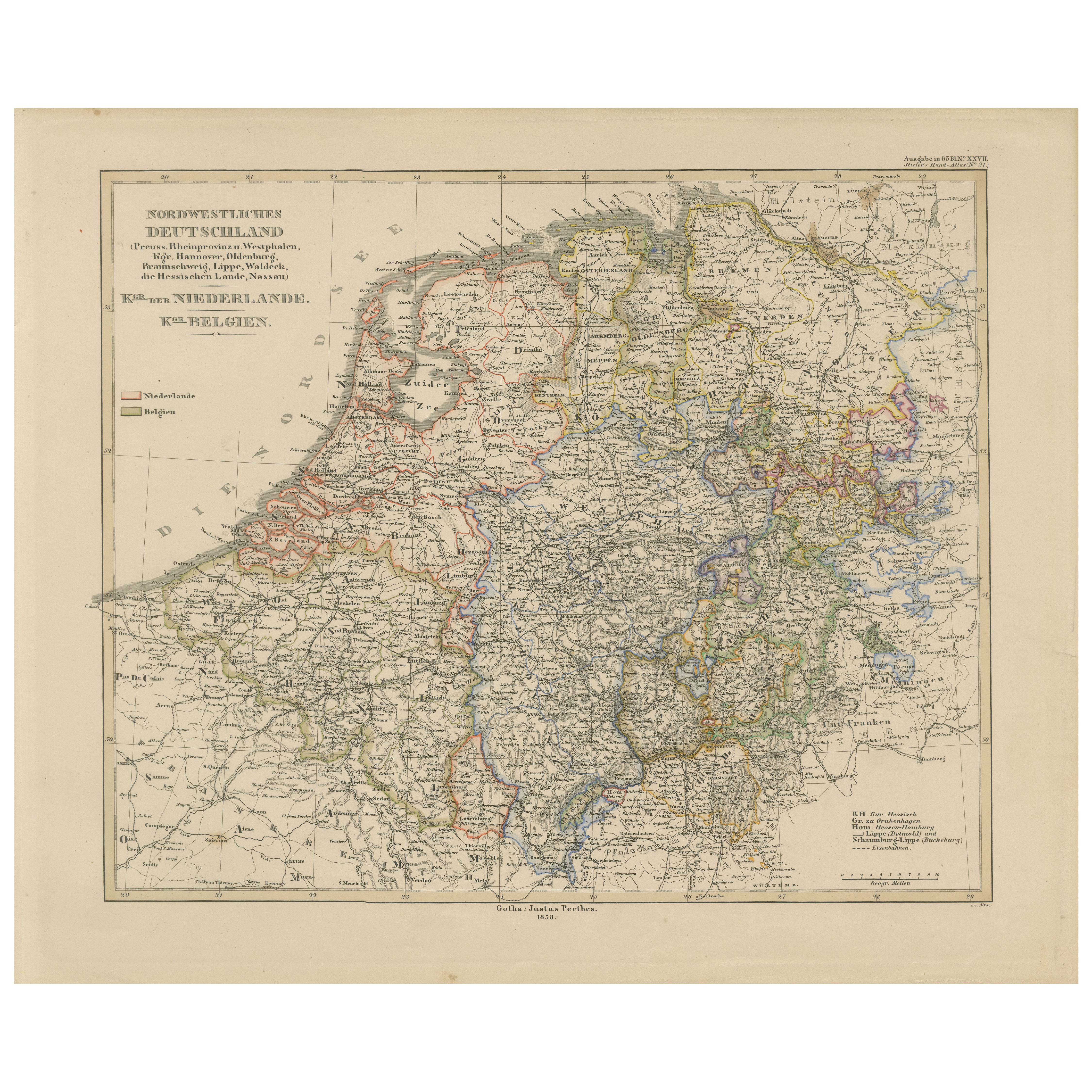
Antique Map of Northwestern Germany, Netherlands & Belgium – 1858
Detailed 19th-century engraved map titled "Nordwestliches Deutschland, Kgr. der Niederlande, Kgr. Belgien" (Northwe...
Category
Antique Mid-19th Century German Maps
Materials
Paper
Antique 1842 Map of Germany by Pierre M. Lapie, Mid-19th Century
Located in Langweer, NL
Antique map titled 'Carte de la Germanie Ancienne'. Map of Germany. This map originates from 'Atlas universel de géographie ancienne et moderne (..)' by...
Category
Antique Mid-19th Century French Maps
Materials
Paper

You May Also Like
1853 Map of "Russia in Europe Including Poland" Ric.r016
Located in Norton, MA
Description
Russia in Europe incl. Poland by J Wyld c.1853
Hand coloured steel engraving
Dimension: Paper: 25 cm W x 33 cm H ; Sight: 22 cm W x 28 cm H
Condition: Good ...
Category
Antique 19th Century Unknown Maps
Materials
Paper

German Empire, Northern Part. Century Atlas antique vintage map
Located in Melbourne, Victoria
'The Century Atlas. German Empire, Northern Part.'
Original antique map, 1903.
Central fold as issued. Map name and number printed on the reverse corne...
Category
Early 20th Century Victorian More Prints
Materials
Lithograph

German Empire, Southwestern Part. Century Atlas antique vintage map
Located in Melbourne, Victoria
'The Century Atlas. German Empire, Southwestern Part'
Original antique map, 1903.
Central fold as issued. Map name and number printed on the reverse co...
Category
Early 20th Century Victorian More Prints
Materials
Lithograph

Austria-Hungary, Western Part. Century Atlas antique vintage map
Located in Melbourne, Victoria
'The Century Atlas. Austria-Hungary, Western Part'
Original antique map, 1903.
Central fold as issued. Map name and number printed on the reverse corners.
Sheet 40cm by 29.5cm.
Category
Early 20th Century Victorian More Prints
Materials
Lithograph

Large Original Antique Map of Poland by Sidney Hall, 1847
Located in St Annes, Lancashire
Great map of Poland
Drawn and engraved by Sidney Hall
Steel engraving
Original colour outline
Published by A & C Black. 1847
Unframed
...
Category
Antique 1840s Scottish Maps
Materials
Paper

1849 Map of "Europaische Russland",
Meyer Map of European Russia
, Ric. R017
Located in Norton, MA
1849 Map of
"Europaische Russland"
( Meyer Map of European Russia)
Ric.r017
A lovely map of European Russia dating to 1849 by Joseph Meyer. It covers the European portions of...
Category
Antique 19th Century Unknown Maps
Materials
Paper

More Ways To Browse
Austrian Empire
Library Collection
Erzgebirge Antique
Beni Ourain Rugs
Glass Top Wood Base Coffee Tables
T Chair
Pair Of Danish Chairs
Veneer Dining Tables
1970 Italian Armchair
Furniture Uk
House Of Denmark Table And Chairs
Louis Marble Top Side Table
Antique Russian Rugs
Baker Furniture By
For Kids
Sterling Silver Flatware Set Service For 12
Tufted Bar
Pair Of French Antique Armchairs