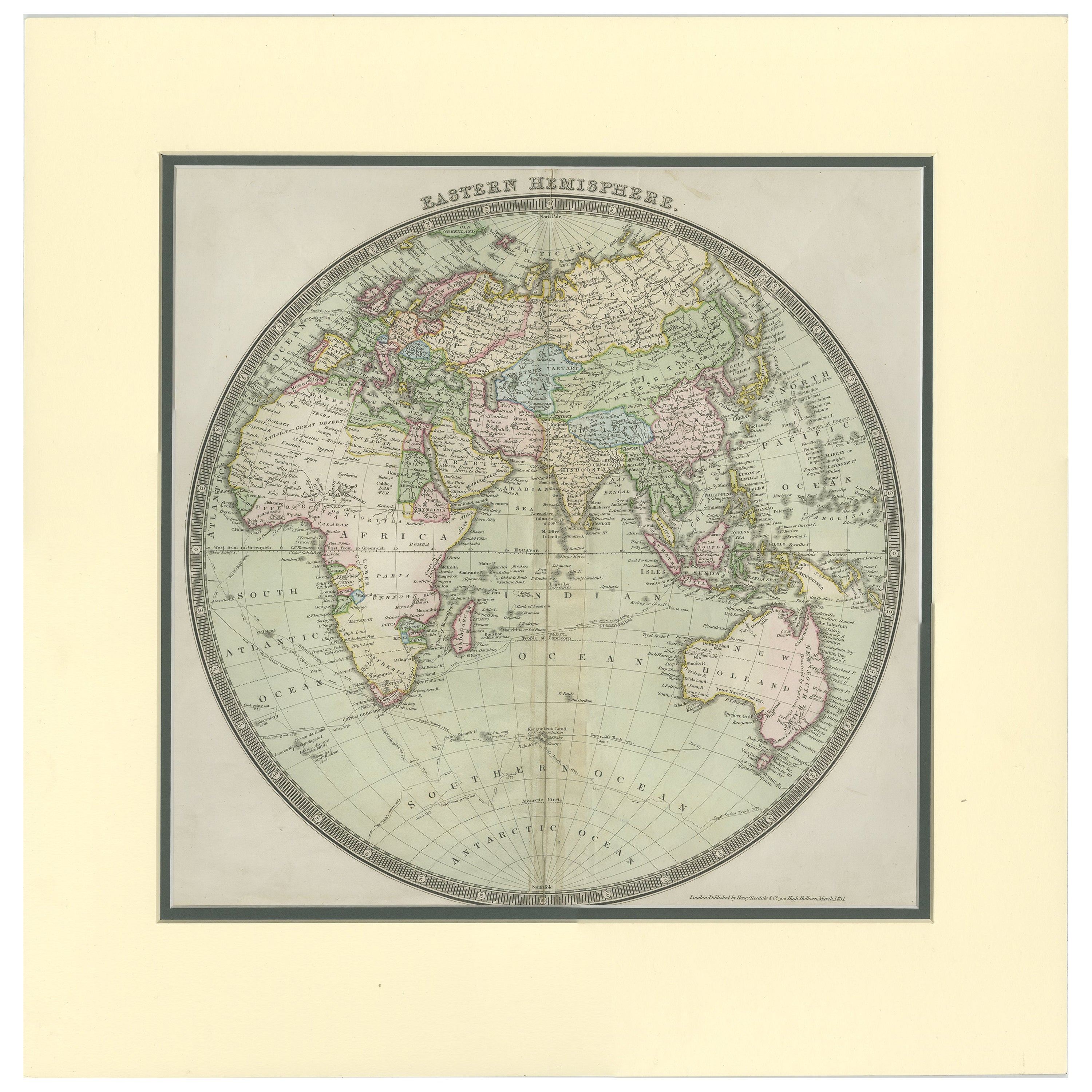
Items Similar to Antique Map of the Eastern Hemisphere by Lapie, France, circa 1830


Want more images or videos?
Request additional images or videos from the seller
1 of 10
Antique Map of the Eastern Hemisphere by Lapie, France, circa 1830
$189.85
£141.73
€160
CA$263.76
A$283.71
CHF 151.62
MX$3,344.12
NOK 1,911.60
SEK 1,747.57
DKK 1,219.38
About the Item
Antique Map of the Eastern Hemisphere by Lapie, France, circa 1830
This finely engraved and hand-colored antique map, titled Hémisphère de l'ancien continent (Eastern Hemisphere), was published in France around 1830 and is attributed to the eminent French cartographer Pierre Lapie or his son Alexandre Émile Lapie. The map presents a hemispherical projection of the "Old World," encompassing Europe, Asia, Africa, and parts of Oceania, including Australia (here labeled "Nouvelle Hollande").
The map reflects a European perspective on world geography during the early 19th century, a time when colonial empires were expanding, and cartographic knowledge was rapidly advancing. Borders are delineated in delicate outline color, highlighting the major empires and regions of the era, including the Ottoman Empire, Persia, China, and British-controlled India. Europe is rendered with precision, while Africa’s interior is still marked by notable blank spaces, reflecting the limited European exploration of the continent at that time.
Asia is boldly defined, with major regions such as Tartary, Siberia, Arabia, and Indostan labeled prominently. Southeast Asia includes well-documented island groups such as the Philippines, the Sunda Islands, and the Moluccas. Japan, labeled as "Japon," appears in a rudimentary but recognizable form. The mapping of Australia under the label "Nouvelle Hollande" reveals the transitional nomenclature before the widespread adoption of the name "Australia," suggesting a publication date prior to the 1840s.
The southern polar regions, labeled as "Terres Australes Antarctiques," remain speculative, as Antarctica had not yet been fully explored or confirmed. The map also features geographic lines including the equator, tropics, and the polar circle, along with ocean names and wind directions.
Published as part of an educational or geographical atlas series, this map is numbered “No. 5” in the upper left corner. The clarity of the engraving and the restrained yet elegant hand coloring make it a visually compelling artifact of Enlightenment and post-Enlightenment cartography.
Condition report:
Good condition with original hand color. Some scattered foxing mostly in the margins and a few faint spots within the image area. Wide margins and strong plate impression. No major tears or repairs.
Framing tips:
This map would benefit from an archival-quality mount with a soft cream or antique white mat to enhance the aged paper and subtle coloring. A simple gilt or black-and-gold neoclassical frame will complement its historical character. For best preservation, use UV-protective glazing.
- Dimensions:Height: 11.62 in (29.5 cm)Width: 16.42 in (41.7 cm)Depth: 0.01 in (0.2 mm)
- Materials and Techniques:
- Period:
- Date of Manufacture:circa 1830
- Condition:Good condition with original hand color. Some scattered foxing mostly in the margins and a few faint spots within the image area. Wide margins and strong plate impression. No major tears or repairs.
- Seller Location:Langweer, NL
- Reference Number:Seller: BG-13384-71stDibs: LU3054345054282
About the Seller
5.0
Recognized Seller
These prestigious sellers are industry leaders and represent the highest echelon for item quality and design.
Platinum Seller
Premium sellers with a 4.7+ rating and 24-hour response times
Established in 2009
1stDibs seller since 2017
2,836 sales on 1stDibs
Typical response time: 1 hour
- ShippingRetrieving quote...Shipping from: Langweer, Netherlands
- Return Policy
More From This Seller
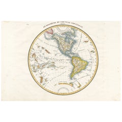
View AllAntique Map of the Western Hemisphere by Lapie, France, circa 1830
Located in Langweer, NL
Antique Map of the Western Hemisphere by Lapie, France, circa 1830
This beautifully engraved and delicately hand-colored map, titled Hémisphère du Nouveau Continent (Ouest), depict...
Category
Antique 1830s Maps
Materials
Paper
Antique Map of the Eastern Hemisphere by Wyld, 1842
Located in Langweer, NL
Antique map titled 'Eastern Hemisphere'. Large map depicting the continents Europe, Asia, Afrika and Australia.
Artists and Engravers: James Wyld (1812–1887) was a British geograph...
Category
Antique 19th Century Maps
Materials
Paper

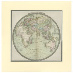
Antique Map of the Eastern Hemisphere by Teesdale,
1831
Located in Langweer, NL
Antique map titled 'Eastern Hemisphere'. Hemispherical map of eastern hemisphere showing tracks of the navigators James Cook and John Gore. Plate 1 fro...
Category
Antique Mid-19th Century Maps
Materials
Paper
$237 Sale Price
20% Off
Very Decorative Original Antique Map of the World, Published in France in c.1780
By Rigobert Bonne
Located in Langweer, NL
Antique map titled 'L'Ancien Monde Et Le Nouveau en Deux Hemispheres' - Double hemisphere map of the World, showing the contemporary geographical...
Category
Antique 18th Century French Maps
Materials
Paper

$548 Sale Price
40% Off
Antique Map of the Eastern Hemisphere by Wyld
1845
Located in Langweer, NL
Antique map titled 'Eastern Hemisphere'. Original antique map of the eastern hemisphere. This map originates from 'An Atlas of the World, Comprehending Separate Maps of its...
Category
Antique Mid-19th Century Maps
Materials
Paper

$332 Sale Price
20% Off
Original Engraved Antique Map of the World, Colorful and Decorative, C.1780
By Pierre François Tardieu
Located in Langweer, NL
Antique map titled 'Mappemonde en Deux Hemispheres ou l'on a Indique les Nouvelles Decouvertes' - This handsome double hemisphere map presents a ...
Category
Antique 18th Century Maps
Materials
Paper

$446 Sale Price
20% Off
You May Also Like
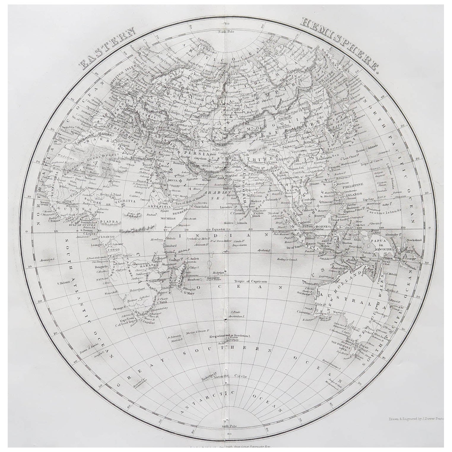
Original Antique Map of The Eastern Hemisphere by Dower, circa 1835
Located in St Annes, Lancashire
Nice map of the Eastern Hemisphere
Drawn and engraved by J.Dower
Published by Orr & Smith. C.1835
Unframed.
Free shipping
Category
Antique 1830s English Maps
Materials
Paper

Original Antique Map of The World by Dower, circa 1835
Located in St Annes, Lancashire
Nice map of the World
Drawn and engraved by J.Dower
Published by Orr & Smith. C.1835
Unframed.
Free shipping
Category
Antique 1830s English Maps
Materials
Paper

Original Antique Map of The Western Hemisphere by Dower, circa 1835
Located in St Annes, Lancashire
Nice map of the Western Hemisphere
Drawn and engraved by J.Dower
Published by Orr & Smith. C.1835
Unframed.
Free shipping
Category
Antique 1830s English Maps
Materials
Paper

Antique Map of Eastern Hemisphere from the collection of Thierry Despont
Located in New York, NY
Designed by Enrico Bonetti (E. Bonatti) and published by Francesco Vallardi Editore. Based on an earlier map by Evangelista Azzi (Ev. Azzi). Labeled as such at bottom edge of map.
T...
Category
Antique Late 19th Century Italian Maps
Materials
Canvas, Wood

Original Antique Map of The World by Thomas Clerk, 1817
Located in St Annes, Lancashire
Great map of The Eastern and Western Hemispheres
On 2 sheets
Copper-plate engraving
Drawn and engraved by Thomas Clerk, Edinburgh.
Published by Mackenzie And Dent, 1817
...
Category
Antique 1810s English Maps
Materials
Paper

Antique 1803 Italian Map of Asia Including China Indoneseia India
Located in Amsterdam, Noord Holland
Antique 1803 Italian Map of Asia Including China Indoneseia India
Very nice map of Asia. 1803.
Additional information:
Type: Map
Country of Manufacturing: Europe
Period: 19th centu...
Category
Antique 19th Century European Maps
Materials
Paper

$438 Sale Price
39% Off
More Ways To Browse
Philippines Antique
Japanese Labels
British Antique China
Round Table Base
Cream Soup
Early English Silver
James Bond
Paisley Rugs and Carpets
Antique Pagoda
Black And Chrome Lounge Chair
Ceramic 1960s Italy
Vintage 1930 Dining Room Set
Antique Brass And Copper
Antique Cow
Antique Harvest
Antique Victorian Dining Tables
Environment Furniture
Italian Plastic Chairs