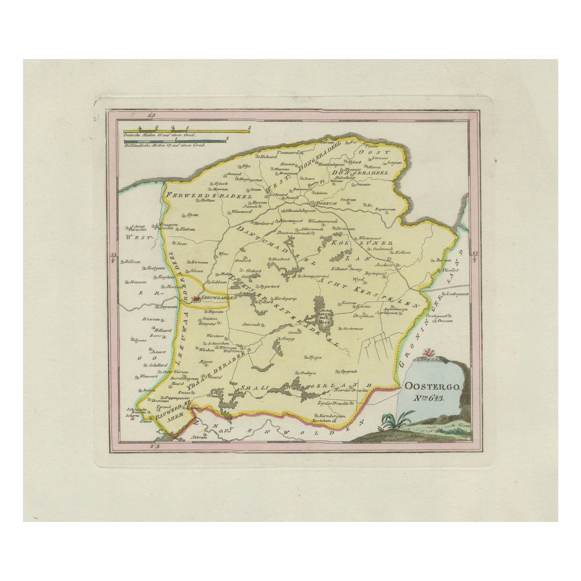
Items Similar to Antique Map of Eastern Oostergo, Friesland by von Reilly, 1791


Want more images or videos?
Request additional images or videos from the seller
1 of 11
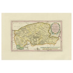
Antique Map of Eastern Oostergo, Friesland by von Reilly, 1791
$468.35
£346.88
€390
CA$640.68
A$697.26
CHF 369.61
MX$8,388.52
NOK 4,687.90
SEK 4,289.10
DKK 2,971.87
About the Item
Antique Map of Eastern Oostergo, Friesland by von Reilly, 1791
Original engraved map titled Der Provinz Oostergo sechs östliche Grietenyen No. 643, published in Vienna in 1791. This map shows the eastern districts of Oostergo in Friesland, with numerous villages, towns, waterways, and agricultural lands carefully engraved and highlighted with original hand coloring. The sheet is from Franz Joseph Johann von Reilly’s atlas Schauplatz der fünf Theile der Welt, engraved by Ignaz Alberti in Vienna, 1791.
Major settlements depicted include Kollum, Buitenpost, Augustinusga, Drogeham, Harkema, Twijzel, Twijzelerheide, Westergeest, Oudwoude, Burum, Lutjegast (just over the border in Groningen), Gerkesklooster, Stroobos, and Surhuizum. Smaller villages and parishes noted include Veenwouden (Feanwâlden), Kooten (Koatstertille area), Zwagerveen, Kuikhorne, Drogeham, Dantumawoude, Damwoude, Rinsumageest, Driesum, Broeksterwoude, Murmerwoude, Ee, Wetsens, and Engwierum. The map also shows waterways such as the Dokkumer Ee, polder divisions, and extensive reclaimed farmland.
This map offers a snapshot of the landscape of eastern Friesland at the close of the 18th century, when the area was shaped by agriculture, waterways, and local administration through grietenijen (districts). Its wealth of place names makes it particularly valuable for regional historians and genealogists.
The title cartouche in the lower right corner is framed with foliage, a characteristic design element of von Reilly’s atlas. With fine engraving and original hand color, the sheet is both a decorative and historical document of Friesland.
Condition report: Very good condition with light age toning. A small marginal water stain at the right edge, outside the printed area. Original hand coloring preserved. Blank verso.
Framing tips: A dark wood or ebonized frame with a cream or ivory mat will highlight the engraved detail and coloring. A thin green or ochre inner line can enhance the tones of the boundary coloring and the cartouche.
Technique: Engraving with original hand color
Maker: Franz Joseph Johann von Reilly, engraved by Ignaz Alberti, Vienna, 1791
- Dimensions:Height: 13.39 in (34 cm)Width: 20.08 in (51 cm)Depth: 0.01 in (0.2 mm)
- Materials and Techniques:Paper,Engraved
- Place of Origin:
- Period:
- Date of Manufacture:1791
- Condition:Condition report: Very good condition with light age toning. A small marginal water stain at the right edge, outside the printed area. Original hand coloring preserved. Blank verso.
- Seller Location:Langweer, NL
- Reference Number:Seller: BG-13229-151stDibs: LU3054346690562
About the Seller
5.0
Recognized Seller
These prestigious sellers are industry leaders and represent the highest echelon for item quality and design.
Platinum Seller
Premium sellers with a 4.7+ rating and 24-hour response times
Established in 2009
1stDibs seller since 2017
2,813 sales on 1stDibs
Typical response time: 1 hour
- ShippingRetrieving quote...Shipping from: Langweer, Netherlands
- Return Policy
More From This Seller
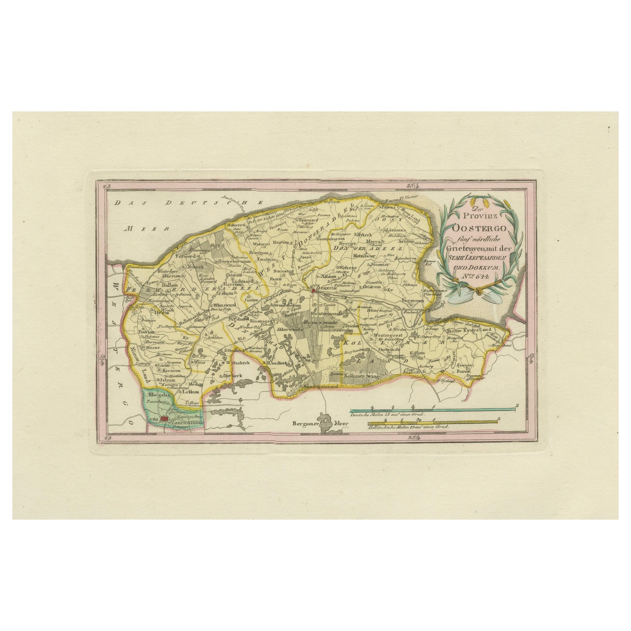
View AllAntique Map of Leeuwarden and Dokkum, Friesland by von Reilly, 1791
Located in Langweer, NL
Antique Map of Leeuwarden and Dokkum, Friesland by von Reilly, 1791
Original engraved map titled Der Provinz Oostergo fünf nördliche Grietenyen, mit der Stadt Leeuwarden und Dokkum ...
Category
Antique 18th Century Austrian Maps
Materials
Paper
Antique Map of Oostergo, Friesland by von Reilly, 1791
Located in Langweer, NL
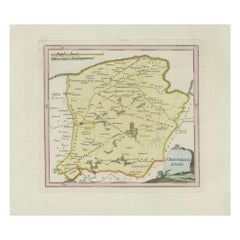
Antique Map of Oostergo, Friesland by von Reilly, 1791
Original engraved map titled 'Oostergo No. 643', published in Vienna in 1791. This map depicts the historic region of Oostergo...
Category
Antique 18th Century Austrian Maps
Materials
Paper
Antique Map of Friesland by Von Reilly, 1791
Located in Langweer, NL
Antique map titled 'Friesland'. Map of the province of Friesland, the Netherlands. This map orginates from 'Schauplatz der fünf Theile der Welt'. Artists and Engravers: Franz Joseph ...
Category
Antique 18th Century Austrian Maps
Materials
Paper

Antique Map of Southern Westergo, Friesland by von Reilly, 1791
Located in Langweer, NL
Antique Map of Southern Westergo, Friesland by von Reilly, 1791
Original engraved map titled Westergoo Norde, published in Vienna in 1791. This sheet depicts the southern and coasta...
Category
Antique 18th Century Austrian Maps
Materials
Paper
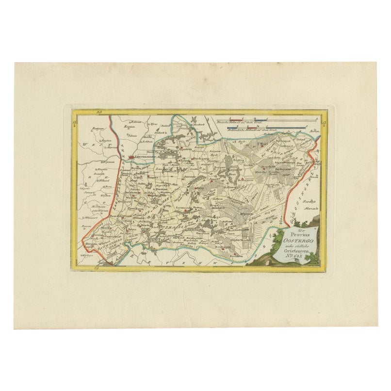
Antique Map of Oostergo by Von Reilly, 1791
Located in Langweer, NL
Antique map titled 'Der Provinz Oostergo sechs südliche Grietenyen'. Map of the Oostergo region, Friesland, the Netherlands. This map orginates from 'Schauplatz der fünf Theile der W...
Category
Antique 18th Century Maps
Materials
Paper

$151 Sale Price
20% Off
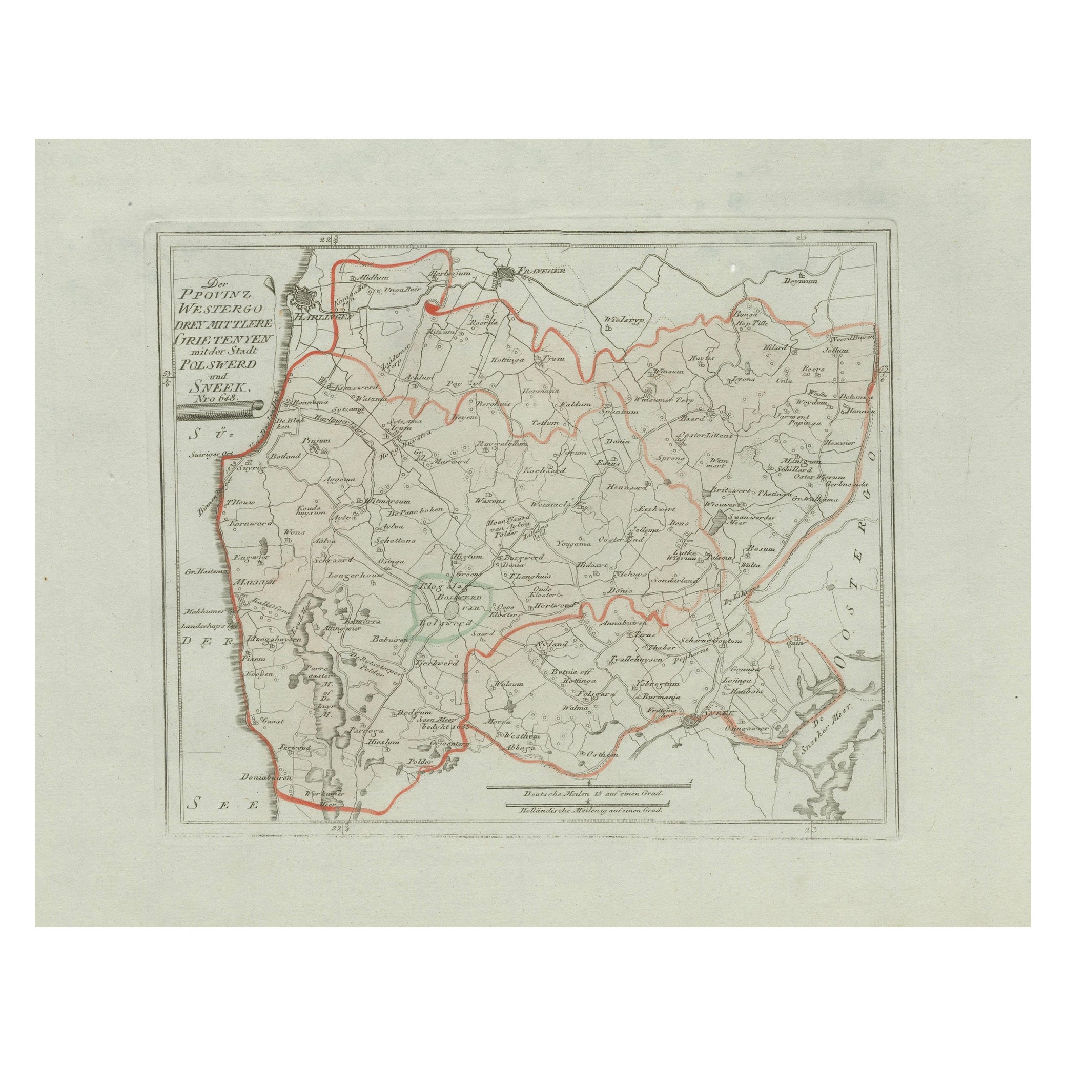
Antique Map of Sneek and Bolsward, Friesland – Dutch Provincial Map, 1791
Located in Langweer, NL
Antique Map of Sneek and Bolsward, Friesland by von Reilly, 1791
Original engraved map titled Der Provinz Westergo drey mittlere Grietenyen, mit der Stadt Bolsward und Sneek No. 641...
Category
Antique 18th Century Austrian Maps
Materials
Paper

You May Also Like
1752 Vaugoundy Map of Flanders : Belgium, France, and the Netherlands, Ric.a002
Located in Norton, MA
Large Vaugoundy Map of Flanders:
Belgium, France, and the Netherlands
Colored -1752
Ric.a002
Description: This is a 1752 Didier Robert de Vaugondy map of Flanders. The map de...
Category
Antique 17th Century Unknown Maps
Materials
Paper

Map Southern Scotland Thomas Conder Alex Hogg 1795
Located in BUNGAY, SUFFOLK
A new map of the southern part of Scotland containing the counties of Stirling, Lanerk, Renfrew, Linlithgow, Edinburgh, Peebles, Haddingtoun, Berwick, Selkirk, Roxburgh, Dumfries, Wigtoun, Kirkudbright & Air
Published by Alex Hogg at the Kings Arms...
Category
Antique 18th Century English Georgian Maps
Materials
Paper

1771 Bonne Map of Poitou, Touraine and Anjou, France, Ric.a015
Located in Norton, MA
1771 Bonne Map of Poitou,
Touraine and Anjou, France
Ric.a015
1771 Bonne map of Potiou, Touraine and Anjou entitled "Carte des Gouvernements D'Anjou et du Saumurois, de la Touraine, du Poitou,du Pays d'aunis, Saintonge?Angoumois,"
Carte des gouvernements d'Anjou et du Saumurois, de la Touraine, du Poitou, du Pays d'Aunis, Saintonge-Angoumois. Projettee et assujettie au ciel par M. Bonne, Hyd. du Roi. A Paris, Chez Lattre, rue St. Jacques a la Ville de Bord(ea)ux. Avec priv. du Roi. 1771. Arrivet inv. & sculp., Atlas moderne ou collection de cartes sur toutes...
Category
Antique 17th Century Unknown Maps
Materials
Paper

1839 Map of Karte Des "Russischen Reiches in Europa Und Asien" Ric.R0013
Located in Norton, MA
1839 map of Karte Des
"Russischen Reiches in Europa and Asien"
Ric.r013
Map of the European and Asian parts of Russian Empire. Karte der Russischen Reiches in Europa und Asien...
Category
Antique 19th Century Unknown Maps
Materials
Paper

18th Century Emanuel Bowen Map of County of York, c.1740
By Emanuel Bowen
Located in Royal Tunbridge Wells, Kent
Antique 18th century British rare and original Emanuel Bowen (1694-1767) map of the County of York divided into its Ridings and subdivided into wapontakes, mounted in solid wood fram...
Category
Antique Early 18th Century British Maps
Materials
Paper

1635 Willem Blaeu Map of Northern France"Comitatvs Bellovacvm" Ric.a08
Located in Norton, MA
1635 Willem Blaeu map of northern France, entitled.
"Comitatvs Bellovacvm Vernacule Beavvais,"
Colored
Ric.a008
“COMITATVS BELLOVACVM…” Amsterdam: W...
Category
Antique 17th Century Unknown Maps
Materials
Paper
