Items Similar to Antique Map of Egypt with Detailed Inset of the Nile Delta, ca. 1799


Video Loading
Want more images or videos?
Request additional images or videos from the seller
1 of 12
Antique Map of Egypt with Detailed Inset of the Nile Delta, ca. 1799
$550.19
£408.55
€460
CA$755.88
A$821.79
CHF 435.71
MX$9,851.16
NOK 5,537.69
SEK 5,073.28
DKK 3,506.68
About the Item
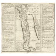
Antique Map of Egypt with Detailed Inset of the Nile Delta, ca. 1799
This finely engraved antique map titled Carte Physique et Politique de l’Égypte presents a detailed and scientifically informed view of Egypt during the Napoleonic period, created around the year An VII (1799) during the French Republic. The map was produced by E. Mentelle and P.G. Chanlaire, both prominent French geographers and contributors to the monumental Atlas National. It was published in Paris and includes two publisher addresses: P.G. Chanlaire, Rue Geoffroy-Langevin No. 528, and E. Mentelle, Galerie du Louvre No. 19.
The map captures Egypt in both its physical and political aspects, tracing the full course of the Nile River from Nubia in the south through Haute (Upper) and Basse (Lower) Egypt, all the way to its multiple mouths flowing into the Mediterranean Sea. A particularly notable feature is the large inset titled Carte Particulière et Détaillée du Delta, offering a highly detailed view of the Nile Delta region. It meticulously charts the branches of the river, canals, and numerous towns including Alexandria, Rosetta, Damietta, Mansourah, Belbeis, and Cairo (Le Caire).
Shaded relief and detailed line work represent the mountainous and desert regions such as the Grand Désert and Arabia Pétrée. The map also shows the Red Sea (Mer Rouge), the Gulf of Suez (Bahr el Kolzoum), and nearby islands such as the Isles de Tiran. Historical and ancient territorial names are included, such as Libye des Anciens, Bohheireh, Kallioubyeh, and Cherqyeh, blending classical geography with contemporary political divisions of the time.
Mentelle and Chanlaire’s collaboration reflects Enlightenment-era geographical scholarship and French strategic interests during Napoleon’s Egyptian campaign. The map includes several different measurement scales, such as ancient miles, Arab parasangs, and French geographic leagues, making it a precise and scholarly cartographic work.
Condition:
The map is in good condition for its age. It shows original folds as issued. There are minor signs of age including slight foxing and soft toning, mainly in the margins. The engraved lines remain crisp, and the original hand-coloring, particularly along the coastlines and water bodies, is well preserved.
Framing suggestion:
This map would look elegant in a simple wooden or gilt frame with a neutral archival mat in ivory or light beige to complement the subtle coloring. It is recommended to use UV-protective glass to preserve the paper and ink. Due to its layout and inset, a horizontal framing format is ideal.
- Dimensions:Height: 20.56 in (52.2 cm)Width: 25.6 in (65 cm)Depth: 0.01 in (0.2 mm)
- Materials and Techniques:Paper,Engraved
- Place of Origin:
- Period:
- Date of Manufacture:1802
- Condition:The map is in good condition for its age. It shows original folds as issued. There are minor signs of age including slight foxing and soft toning, mainly in the margins. The engraved lines remain crisp, the original hand-coloring well preserved.
- Seller Location:Langweer, NL
- Reference Number:Seller: BG-13769-411stDibs: LU3054345616602
About the Seller
5.0
Recognized Seller
These prestigious sellers are industry leaders and represent the highest echelon for item quality and design.
Platinum Seller
Premium sellers with a 4.7+ rating and 24-hour response times
Established in 2009
1stDibs seller since 2017
2,823 sales on 1stDibs
Typical response time: 1 hour
- ShippingRetrieving quote...Shipping from: Langweer, Netherlands
- Return Policy
More From This Seller
View AllAntique Map of The Nile, Egypt and the Red Sea by Bachiene, 1765
Located in Langweer, NL
Antique map titled 'De XIde Landkaart verbeeldende Egypte en de Woestyne der Schelf-Zee (..).' Map of Biblical Egypt and the Red Sea. With title cartouche, compass rose and scale. Th...
Category
Antique 18th Century Maps
Materials
Paper

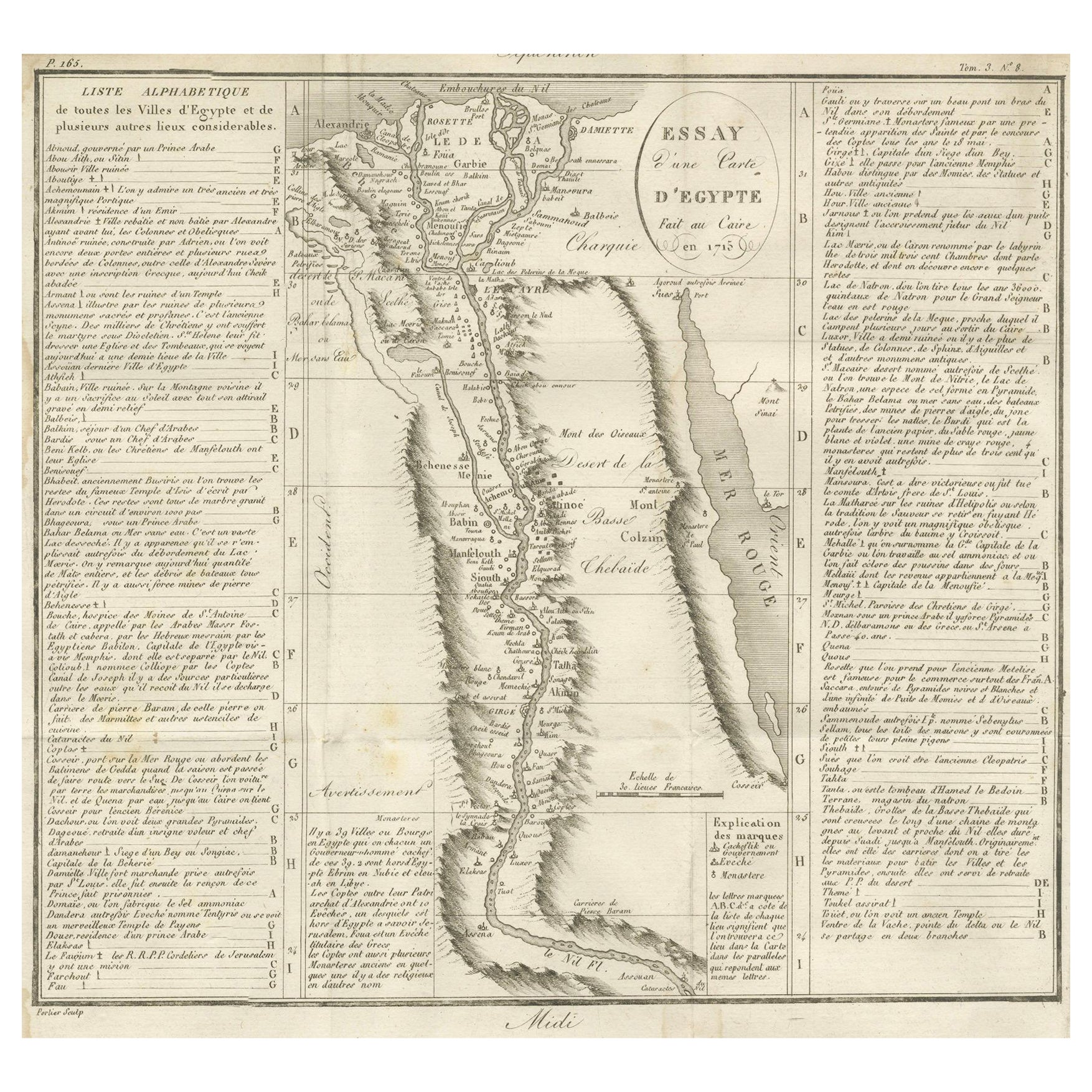
Antique Map of Egypt and the Nile Valley with City Index, 1715
Located in Langweer, NL
Antique map of Egypt, titled "Essay d'une Carte d'Égypte Fait au Caire en 1715".
This finely engraved map presents a detailed depiction of Egypt along the Nile River from the Medit...
Category
Antique Early 18th Century French Maps
Materials
Paper
Egypt
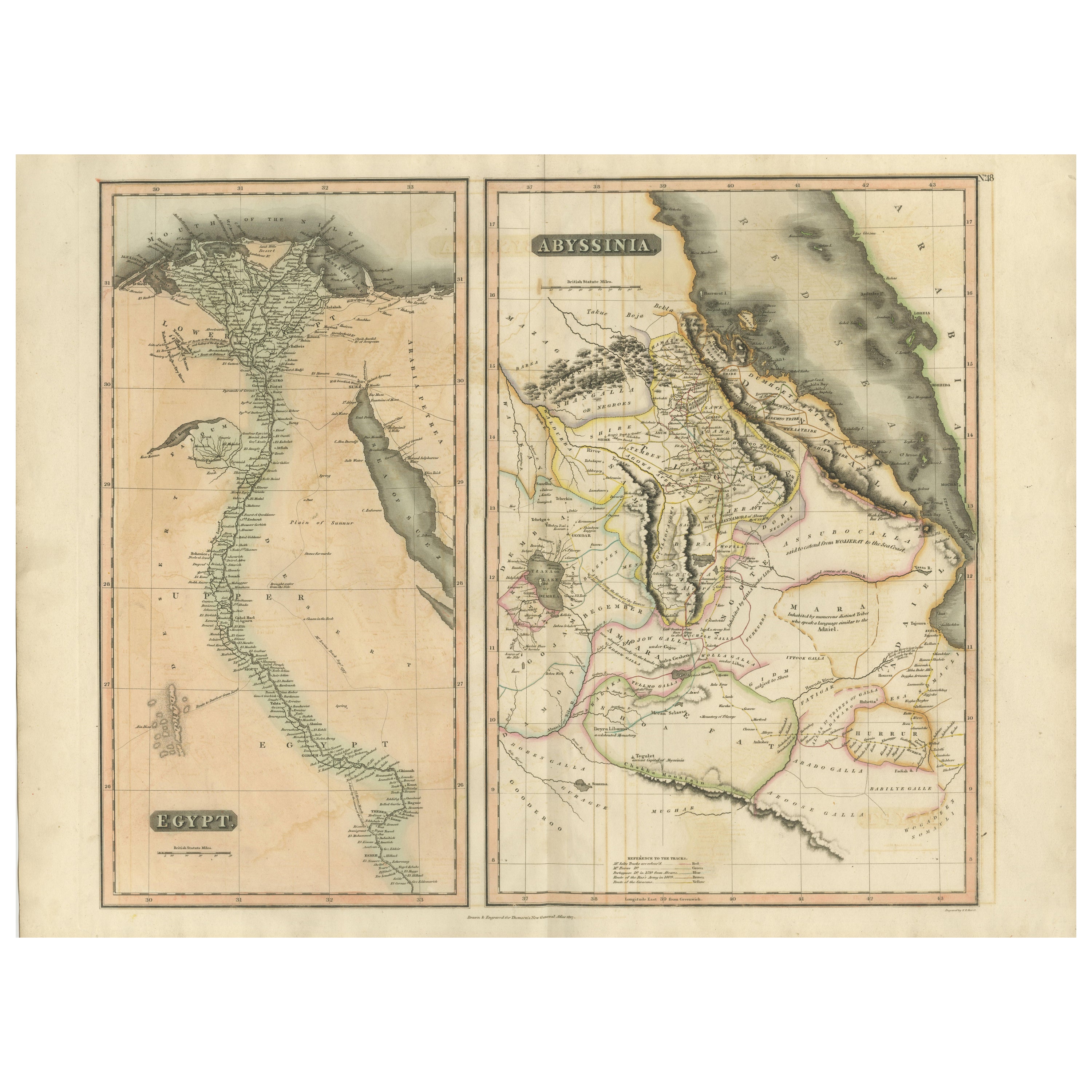
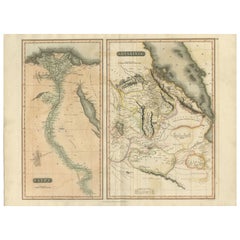
Abyssinia – Original Nile Valley and Horn of Africa Maps, c.1817
Located in Langweer, NL
Egypt & Abyssinia – Nile Valley and Horn of Africa Maps, c.1817–1820
This refined early 19th-century map composition presents two related geographic views of Northeast Africa: Egypt...
Category
Antique 1810s British Maps
Materials
Paper
Antique Map of Ancient Egypt Also Depicting the Nile River and Red Sea, 1845
Located in Langweer, NL
Antique map Egypt titled 'General Karte von Alt Aegypten von A.H. Brué'. Large map of Egypt also depicting the Nile river and Red Sea. Source unknown...
Category
Antique 19th Century Maps
Materials
Paper

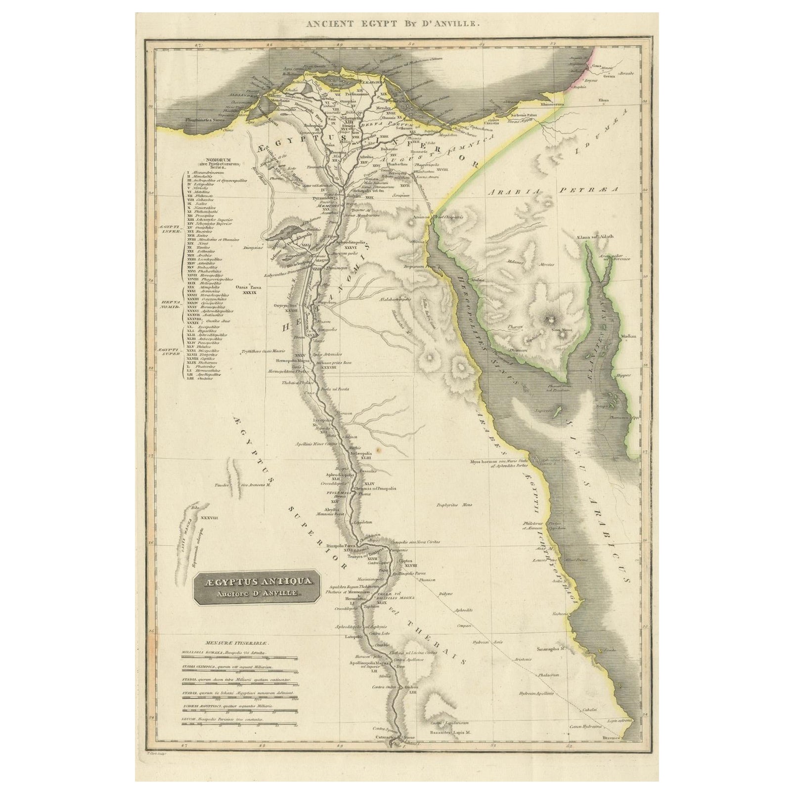
Ancient Egypt – Nile Valley Map by d’Anville, Classical Antiquity, c.1765
Located in Langweer, NL
Ancient Egypt – Nile Valley Map by d’Anville, Classical Antiquity, c.1765
This finely engraved map depicts Ancient Egypt as understood through classical sources, extending along the...
Category
Antique 1760s French Maps
Materials
Paper
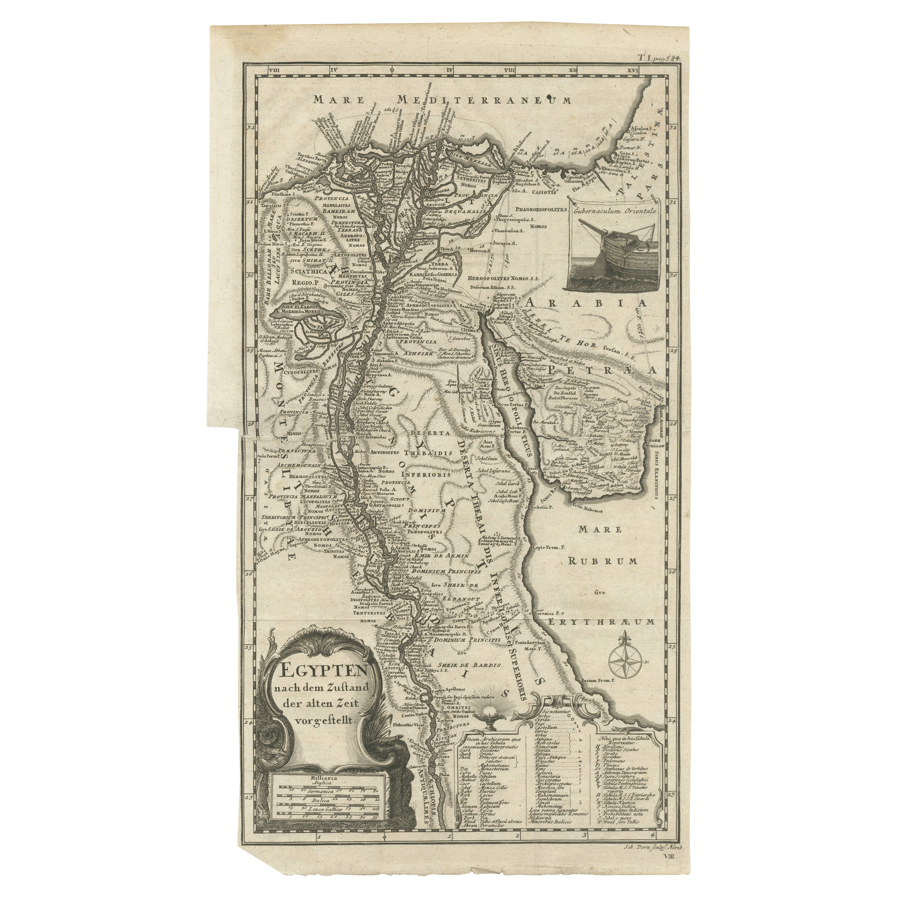
Antique Map of Egypt and the Nile River
Located in Langweer, NL
Antique map titled 'Egypten nach dem Zustand der alten Zeit vorgestellt'. This uncommon and richly detailed map of Egypt features hundreds of place names along the Nile. The Sinai Pe...
Category
Antique Mid-18th Century Maps
Materials
Paper
$325 Sale Price
20% Off
You May Also Like
Map of the Holy Land "Carte de la Syrie et de l
Egypte" by Pierre Lapie
By Pierre M. Lapie
Located in Alamo, CA
This is an early 19th century map of ancient Syria and Egypt entitled "Carte de la Syrie et de l'Egypte anciennes/dressée par M. Lapie, Colonel d'Etat M...
Category
1830s Landscape Prints
Materials
Engraving

Map of Nubia and Abissinia - Original Etching by Antonio Zatta - 1784
Located in Roma, IT
This Map of Nubia and Abissinia is an etching realized by Antonio Zatta in Venice in 1784.
The state of preservation of the artwork is good expect for the worn paper with some littl...
Category
1770s Landscape Prints
Materials
Etching

Original Antique Map of Ancient Greece, Achaia, Corinth, 1786
Located in St Annes, Lancashire
Great map of Ancient Greece. Showing the region of Thessaly, including Mount Olympus
Drawn by J.D. Barbie Du Bocage
Copper plate engraving by P.F Tardieu
Original hand color...
Category
Antique 1780s French Other Maps
Materials
Paper

Map of the Holy Land "Carte de la Syrie et de l
Egypte" by Pierre M. Lapie
By Pierre M. Lapie
Located in Alamo, CA
An early 19th century map of ancient Syria and Egypt entitled "Carte de la Syrie et de l'Egypte anciennes/dressée par M. Lapie, Colonel d'Etat Major, et...
Category
Antique Early 19th Century French Maps
Materials
Paper

$620 Sale Price
20% Off
Original Antique Map of Ancient Greece- Boeotia, Thebes, 1787
Located in St Annes, Lancashire
Great map of Ancient Greece. Showing the region of Boeotia, including Thebes
Drawn by J.D. Barbie Du Bocage
Copper plate engraving by P.F T...
Category
Antique 1780s French Other Maps
Materials
Paper

Large Original Antique Map of Morocco. Edward Weller, 1861
Located in St Annes, Lancashire
Great map of Morocco
Lithograph engraving by Edward Weller
Original colour
Published, 1861
Unframed
Good condition.
Category
Antique 1860s English Victorian Maps
Materials
Paper

More Ways To Browse
Napoleon Egypt
Antique Victorian Dining Tables
Italian Plastic Chairs
Black Crystal Glasses
French Mid Century Modern Rug
China Silk Rug
Chrome Glass Coffee Tables
Antique Italian Chairs
Antique Walnut Bar
Beni Ourain Rugs
French Iron And Glass Table
Glass Top Wood Base Coffee Tables
T Chair
Antique Silver Basket
Antique Walkers
Ebony Wood Furniture
Opalescent Glass
Pair Of Danish Chairs